.jpg/250px-La_Havel_à_Potsdam_(36928106751).jpg "Havel")
.jpg)
Community hub
Recent from talks
Contribute something
Nothing was collected or created yet.
Havel
View on Wikipedia
| Havel | |
|---|---|
.jpg) The Havel in Potsdam | |
 Rivers Havel (dark blue) and Rhin (turquoise) | |
 | |
| Location | |
| Country | Germany |
| Cities | |
| Physical characteristics | |
| Source | |
| • location | Ankershagen, Mecklenburg |
| • coordinates | 53°28′04″N 12°56′08″E / 53.467778°N 12.935556°E |
| • elevation | 65 m (213 ft) |
| Mouth | Elbe |
• location | Rühstädt-Gnevsdorf |
• coordinates | 52°54′30″N 11°52′38″E / 52.908333°N 11.877222°E |
• elevation | 22 m (72 ft) |
| Length | 324 km (201 miles) |
| Basin size | 23,858 km2 (9,212 sq mi) |
| Discharge | |
| • location | Havelberg |
| • average | 103 m3/s (3,600 cu ft/s) |
| • minimum | 18.8 m3/s (660 cu ft/s) |
| • maximum | 215 m3/s (7,600 cu ft/s) |
| Basin features | |
| Progression | Elbe→ North Sea |
| Tributaries | |
| • left | Woblitz, Briese, Tegeler Fließ, Spree, Nuthe, Plane, Buckau |
| • right | Rhin, Dosse |
The Havel (German: [ˈhaːfl̩] ⓘ)[1] is a river in northeastern Germany, flowing through the states of Mecklenburg-Vorpommern, Brandenburg, Berlin and Saxony-Anhalt. The 325-kilometre-long (202 mi) Havel is a right tributary of the Elbe. However, the direct distance from its source to its mouth is only 94 kilometres (58 mi). For much of its length, the Havel is navigable; it provides an important link in the waterway connections between the east and west of Germany, as well as beyond.
Source
[edit]The source of the Havel is located in the Mecklenburg Lake District, between Lake Müritz and the city of Neubrandenburg. There is no obvious visible source in the form of a spring, but the river originates in the lakes in the Diekenbruch near Ankershagen, close to and south-east of the watershed between the North and Baltic seas. From there the river initially flows southward, eventually joining the Elbe, which in turn flows into the North Sea. Every river north-east of it flows to the Baltic Sea. The river enters Brandenburg near the town of Fürstenberg. In its upper course and between Berlin and Brandenburg an der Havel the river forms several lakes.
The Havel's main tributary is the Spree, which joins the Havel in Spandau, a western borough of Berlin, and is longer and delivers more water than the Havel itself above the confluence. The second largest tributary is the Rhin, named in the Middle Ages by settlers from the lower Rhine. At the southern end of the Ruppiner See, weirs can distribute the waters of the Rhin either east- or westwards, rejoining the Havel in two places 67 kilometres (42 mi) apart along a straight line, and more than 160 kilometres (99 mi) apart along the course of the river.
The region around and north of the middle Havel is called the Havelland. It consists of sandy heights, sometimes called Ländchen, and low marshes, called luchs. A few kilometres of the river before its confluence with the Elbe near Havelberg are in the State of Saxony-Anhalt. Due to its minimal gradient it is susceptible to high waters in the Elbe.
Unless in extreme floods, if the dike of the Elbe is submerged, the discharge of the Havel is improved by the Gnevsdorfer Vorfluter (something like "Gnevsdorfer outfall"). By this canal, the mouth of the Havel, that naturally would be near Havelberg, is placed 11 km downstream. As the course of the Elbe has a higher gradient than the Havel, the water level of the Havel in Havelberg can be kept 1.4 metres below the Elbe (at the junction of the traverse communicating canal, protected by a lock).
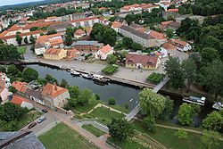
Towns along the river include: Fürstenberg, Zehdenick, Oranienburg, Berlin, Potsdam, Werder, Ketzin, Brandenburg, Premnitz, Rathenow and Havelberg.
History
[edit]In earlier Greek or Latin sources, such as Tacitus's Germania, the name of the river was also written as Habola, Habula, Havela. The river name Havel is related to German Haff, habe, hafen, MHG Hafen meaning port, harbor).[citation needed]
The Slavic people who later moved into the Havel area were referred to in German sources as Heveller (occasionally as Havolane).
Navigation
[edit]The Havel is navigable from the Mecklenburg Lake District to its confluence with the Elbe. Whilst its upper reaches carry little other than leisure traffic, further downstream it provides an important link in the German commercial waterway network, carrying traffic from the Rhine and the North Sea to Berlin and Poland.[2]
From a navigation perspective, the Havel can be split into four sections with somewhat different characteristics and different administrative arrangements.
Head of navigation to Liebenwalde
[edit]

The Havel is navigable to canoes and similar small craft from close to its source. Motor craft are prohibited above the first lock at Zwenzow, which links the Useriner See to the Großer Labussee. The stretch of the river between this lock and the junction with the Oder–Havel Canal is administered as part of the Obere–Havel–Wasserstraße, along with various connecting canals and waterways.[3][4]
From Zwenzow downstream to Liebenwalde is a distance of 92 kilometres (57 mi). In this distance the navigation passes through the lakes of Großer Labussee, Woblitzsee, Wangnitzsee, Großer Priepertsee, Ellbogensee, Ziernsee, Röblinsee, Baalensee, Schwedtsee and Stolpsee. It also descends through the locks at Wesenberg, Steinhavelmühle, Fürstenberg, Bredereiche, Regow, Zaaren, Schorfheide, Zehdenick, Bischofswerder and Liebenwalde.[3][4]
The Woblitzsee also gives access to the Kammer Canal, which allows vessels to reach Neustrelitz. The Ellbogensee links to the Müritz–Havel–Wasserstraße, which proceeds deeper into the Mecklenburg Lake District, eventually connecting with the Müritz–Elde–Wasserstraße. Other connected waterways are the Lychener Gewässer, the Templiner Gewässer and the Wentow Gewässer.[3]
Liebenwalde to Spandau
[edit]
The stretch of the river between the junction with the Oder–Havel Canal near Liebenwalde and the confluence with the Spree at Spandau is administered as part of the Havel–Oder–Wasserstraße, which also includes the Oder-Havel Canal. This stretch of the river forms part of the main inland waterway route from Germany to Poland and carries significant commercial traffic. This stretch of the river is 40 kilometres (25 mi) long, and the river descends through two locks at Lehnitz and Spandau.[5]
At Hennigsdorf, 30 kilometres (19 mi) downstream of Liebenwalde, the Havel Canal joins the river on the west bank. This canal connects to Paretz, on the Havel downstream, and was built in the 1950s to allow East German vessels to avoid the stretch of the river under the political control of West Berlin. Some 7 kilometres (4.3 mi) further downstream, the Berlin-Spandau Ship Canal joins the river on the east bank, providing a connection to central Berlin without passing through the lock at Spandau.[5]
A car ferry crosses the river between Hakenfelde and Konradshöhe, in the Berlin boroughs of Spandau and Reinickendorf respectively.
The last 10 kilometres (6 mi) of this stretch of the river, from Hennigsdorf, passes through a series of interconnected lakes, including the large Tegeler See. The river enters Berlin 6 kilometres (4 mi) before Spandau, having formed the boundary for the previous 4 kilometres (2.5 mi). During the partition of Germany, this formed the border between East Germany and West Berlin, and border control points were established for vessels navigating the river.[5]
Spandau to Plaue
[edit]
The stretch of the river between the confluence with the Spree at Spandau and the junction with the Elbe–Havel Canal at Plaue is administered as part of the Lower Havel–Waterway, which also includes the stretch of river downstream to the confluence with the Elbe. Between Spandau and Plaue, the river forms part of the main inland waterway route from the Rhine and the west of Germany; from Hamburg and the North Sea ports, to both Berlin and Poland. It thus carries a considerable amount of commercial traffic.[2]
South of Spandau, the river widens into a wide lake that extends, through some narrower areas, to Potsdam. On the east bank south of Spandau is the Grunewald with several beaches, among them the Großes Fenster (German pronunciation: [ˈɡʁoːsəs ˈfɛnstɐ] ⓘ; literally "Great Window") with an unobstructed view upriver, hence the name, followed by the island of Schwanenwerder and the large arm known as the Großer Wannsee. This part of the river can be very busy with leisure craft. The island of Pfaueninsel is also a feature of this stretch of the river. A public ferry crosses these waters between Wannsee and Kladow, carrying passengers and cyclists.[2]
The Teltow Canal joins the river from the east via the Griebnitzsee just before the city reaches the city of Potsdam, providing an alternative route to the Oder–Spree Canal avoiding central Berlin. The Griebnitz Canal provides a short cut for smaller vessels from the Griebnitzsee to the Großer Wannsee.[2]
At Potsdam the navigation splits into two channels. The Havel, here known as the Potsdamer Havel, takes a route southwest through Potsdam and the Templiner See to the Schwielowsee, then northwest to Paretz, whilst the Sacrow–Paretz Canal takes a shorter route due east to Paretz, saving some 13 kilometres (8.1 mi) compared to the 29-kilometre (18 mi) Potsdamer Havel. The Potsdamer Havel is crossed by the Kiewitt Ferry in Potsdam itself, and by the Caputh Ferry at the entrance to the Schweilowsee.[2]
.JPG)
At Paretz the two channels join up again, as does the Havel Canal from further upstream. Just downstream of Paretz, the river is crossed by the Ketzin Cable Ferry. At Brandenburg an der Havel, the navigation again splits into two routes. Commercial shipping descends through a lock into the Silo Canal that passes to the north of the city centre. Leisure craft pass through the centre of the city, using the short Brandenburg City Canal, a smaller lock, then a stretch of the river. Both routes rejoin in the linked lakes of Breitling See and Plauer See, which leads up to Plaue.[2]
Plaue to Havelberg
[edit]
Like the preceding stretch of the river, the stretch from Plaue to the confluence with the Elbe at Havelberg is administered as part of the Lower Havel–Waterway. Unlike the previous stretch, this stretch carries considerably less commercial traffic.
Vessels heading to or from the Rhine and the west of Germany take the Elbe–Havel Canal at Plaue. Whilst the lower reaches of the Havel provide the most direct route to Hamburg and the North Sea ports, variable water levels in the Elbe affect those in the lower Havel; together these can restrict navigation. A less direct, but more reliable route is available via the Elbe–Havel Canal, the Magdeburg Water Bridge, the Mittelland Canal and the Elbe Lateral Canal.[2]
This stretch of the river descends through locks at Bahnitz, Rathenow, Grütz, Garz and Havelberg. At Rathenow there are two channels, each with a lock. North of Plaue, the river is crossed by the Pritzerbe Ferry.[2]
Gallery
[edit]-
 Wentow channel in Zehdenick
 -
 Weir of Voss Channel in Liebenwalde-Bischofswerder
 -
 Lehnitz lock in Oranienburg
 -
 Alte Fahrt branch in Potsdam
 -

-

-
 Old harbour in Rathenow
 -
 Gnevsdorf outfall


,_Dom_vom_Wasser_aus.jpg)


See also
[edit]References
[edit]- ^ "Duden | Havel | Rechtschreibung, Bedeutung, Definition, Herkunft".
- ^ a b c d e f g h Sheffield, Barry (1995). Inland Waterways of Germany. St Ives: Imray Laurie Norie & Wilson. pp. 93–100. ISBN 0-85288-283-1.
- ^ a b c Sheffield, Barry (1995). Inland Waterways of Germany. St Ives: Imray Laurie Norie & Wilson. pp. 106–108. ISBN 0-85288-283-1.
- ^ a b "Hauptstrecken Abkürzungen" [Main route abbreviations] (in German). Wasser- und Schifffahrtsverwaltung des Bundes. Archived from the original on 19 July 2011. Retrieved 6 February 2011.
- ^ a b c Sheffield, Barry (1995). Inland Waterways of Germany. St Ives: Imray Laurie Norie & Wilson. pp. 100–103. ISBN 0-85288-283-1.
| International | |
|---|---|
| National | |
| Other | |
Havel
View on GrokipediaGeography
Source and Course
The Havel originates in the Mecklenburg Lake District (Mecklenburgische Seenplatte) within the state of Mecklenburg-Vorpommern, emerging from a network of glacial lakes and streams in the northeast sector of the Müritz National Park, specifically southeast of the Mühlensee near the village of Wustrow.[6][7] Unlike many rivers with a distinct spring, the Havel's upper course begins as an outflow from spring-fed lakes such as the Bornsee east of the Müritz, fed by minor tributaries including the Schwarzer Graben.[8][7] The source elevation is approximately 63 meters above sea level.[1] Over its total length of 334 kilometers, the Havel flows predominantly southward as a lowland river with a minimal gradient, descending about 41 meters to its mouth at 22 meters above sea level.[9][1][10] In its initial stages through Mecklenburg-Vorpommern, it traverses a chain of interconnected lakes—including the Mirow Lakes and the expansive Müritz—forming a braided, lake-dominated system typical of post-glacial terrain before consolidating into a more linear channel.[6][11] Entering Brandenburg, the river maintains a meandering path amid forests and wetlands, developing multiple branches and inland deltas that expand its effective waterway network.[12] The Havel skirts western Berlin, receiving the Spree River at Spandau and incorporating urban waterways through the city, after which it continues southwestward past Potsdam and Werder, forming broad floodplains.[11][13] Further downstream, it flows through Brandenburg an der Havel and Rathenow, characterized by regulated channels and low-velocity flow suited to navigation.[10] The river terminates as a right tributary of the Elbe at Havelberg, on the Brandenburg-Saxony-Anhalt border, where it contributes to the Elbe's discharge after navigating approximately 94 kilometers in direct linear distance despite its winding path.[11][14]Basin and Hydrology
The Havel drainage basin encompasses approximately 24,000 km² in northeastern Germany, predominantly within Brandenburg, with extensions into Mecklenburg-Vorpommern to the north, Berlin in the urban core, and Saxony-Anhalt near the confluence.[1] [15] The basin's morphology reflects post-glacial features, including extensive lakelands (e.g., the Mecklenburg Lake District upstream and the Havel River lowlands downstream) that account for roughly 10% of the area as standing waters, influencing infiltration and baseflow dynamics.[16] Major sub-basins include those of the Rhin and Dosse rivers to the north and the Spree to the east, which joins the Havel in Spandau, Berlin, contributing significantly to downstream flow volumes.[17] Hydrologically, the Havel spans 325 km from its source near Silz in the Mecklenburgische Seenplatte to its right-bank confluence with the Elbe at Havelberg, descending only about 80 meters in elevation, classifying it as a lowland river with minimal gradient (average 0.25 m/km).[1] [15] Mean annual discharge at the mouth averages 88.8 m³/s, derived from precipitation of 500–600 mm/year across the basin, with groundwater from glacial aquifers providing stable baseflow (up to 60% of total runoff in dry periods).[9] The flow regime exhibits moderate seasonality, peaking in late winter/early spring (February–April) due to snowmelt and reduced evapotranspiration, at 100–150 m³/s, and low flows in summer/autumn (below 50 m³/s), exacerbated by agricultural drainage and urban abstraction.[18] [19] Anthropogenic regulation via reservoirs, weirs, and the Spree-Havel canal system has attenuated natural variability, raising low flows by 20–30% while increasing flood risks during high-precipitation events, as evidenced by 1990s and 2013 inundations affecting floodplain retention.[15] The lower basin (ca. 3,830 km² from Plaue to the Elbe) features braided channels and wetlands that historically buffered peaks, though channelization has reduced this capacity by an estimated 40% since the 19th century.[20]History
Early Development and Medieval Modifications
The Havel River, originating in the Mecklenburg Lake District, initially developed as a natural glacial meltwater course following the Weichselian glaciation, with early human utilization tied to Slavic settlements from the 6th to 12th centuries AD, where fortifications and villages clustered along its banks and tributaries for defensive and subsistence purposes.[1] These pre-medieval patterns exploited the river's meandering sections and adjacent wetlands for fishing, agriculture, and transport, but lacked large-scale engineering, as evidenced by archaeological records of unchannelized waterways supporting dispersed Heveller tribal communities.[21] The onset of the High Middle Ages, coinciding with the Ostsiedlung (eastern colonization) around 1150–1300 AD, marked the river's first significant anthropogenic modifications, driven by German settlers establishing mills and settlements that required regulated water flows.[1] Mill dams proliferated along the middle and lower Havel, creating a cascade of impounded lakes that elevated regional water levels by approximately 1.5 meters between 1180 and 1250 AD, as reconstructed from sedimentary proxy data in peat and lake cores.[4] This hydraulic engineering, primarily for powering grain and fulling mills, transformed meandering riverine ecosystems into a series of dammed reservoirs, enhancing navigability for trade while altering groundwater dynamics and floodplain hydrology across the Berlin-Brandenburg region.[22] By the 13th century, these modifications facilitated urban growth, with foundations like Brandenburg an der Havel (first documented 1161 AD) leveraging the stabilized waterway for commerce in timber, salt, and grains, integrating the river into emerging feudal economies.[23] Bridges and fords, such as those at early crossing points, further structured traffic, though prone to seasonal flooding until dam reinforcements; prams (flat-bottomed barges) became standard for bulk transport, underscoring the river's pivot from local Slavic waterway to a vital artery of medieval Brandenburg.[24] Such interventions, while empirically boosting economic output through consistent milling and shipping, initiated long-term ecological shifts, including reduced flow velocities and expanded lacustrine habitats that persisted into later eras.[25]Industrial Era Engineering and Alterations
During the late 19th century, as industrial demands for reliable inland navigation grew in the Prussian province of Brandenburg, the Havel River underwent systematic regulation to improve shipping conditions, reduce meandering, and maintain navigable depths amid fluctuating water levels. These efforts primarily targeted the lower Havel, where natural braiding and sedimentation hindered barge traffic essential for transporting timber, grain, and industrial goods to Berlin and the Elbe. Initial modifications included the installation of groynes (Buhnen) and guide structures (Leitwerken) between 1875 and 1881 to narrow and stabilize the channel, directing flow to scour silt and prevent bank erosion.[20] A key project was the regulation of the Pichelsdorfer Havel section from 1878 to 1882, which involved straightening meanders and reinforcing banks with revetments to accommodate larger vessels amid rising commercial traffic. Concurrently, the Vorstadtschleuse (suburban lock) in Brandenburg an der Havel was constructed between 1881 and 1883, featuring a chamber approximately 60 meters long to manage water level differences and facilitate passage during low flows, marking one of the first modern locks on the river.[26] These works were driven by Prussian hydraulic engineering priorities, which emphasized flood control alongside navigation, though they often prioritized economic utility over ecological preservation.[11] Further alterations followed with the second regulation of the lower Havel from Plaue to Gnevsdorf between 1890 and 1896, extending channel improvements over 50 kilometers by adding more groynes, weirs, and barrages to regulate summer low water and enhance towpath efficiency for horse-drawn barges. Weirs and water gates were also installed across multiple sites to impound water for consistent depths, supporting the industrial-era shift toward steam-powered vessels by the 1890s.[26] These interventions, while boosting transport capacity—evidenced by increased barge traffic volumes documented in Prussian waterway records—reduced the river's natural meandering and floodplain connectivity, contributing to long-term hydrologic alterations.[1] Into the early 20th century, transitional industrial projects under the 1904 "Law for the Improvement of Flood and Shipping Conditions" (from 1904 to 1912) built additional locks and deepened segments, such as the Schleppzugschleuse near Potsdam completed in 1909, to integrate the Havel more fully into Germany's expanding canal network. These engineering feats reflected causal priorities of state-sponsored infrastructure to fuel industrialization, with verifiable outcomes including sustained navigation depths of 1.5 to 2 meters in regulated stretches, though at the cost of diminished riparian habitats.[11][27] Overall, 19th-century modifications transformed the Havel from a dynamic, braided lowland river into a more controlled waterway, aligning with broader European trends in river taming for economic gain.Navigation and Infrastructure
Waterway Segments and Connectivity
The Havel River's navigable portions are divided into three primary segments: the Upper Havel (Obere Havel), Middle Havel (Mittlere Havel), and Lower Havel (Untere Havel), reflecting variations in channel morphology, lake integrations, and administrative classifications as federal waterways.[11] The Lower Havel Waterway (Untere Havel-Wasserstraße, UHW), managed by the Federal Waterways and Shipping Administration (WSV), spans 148.43 kilometers from the Spree-Havel confluence at Berlin-Spandau (km 0) to the Elbe River mouth at Havelberg.[11] This segment features meandering river channels interspersed with lakes like the Tegeler See, Havelsee, and Großer Zernsee, alongside braided sections in the Havelland region that support diverse navigational conditions.[11] The Middle Havel, encompassing the area around Brandenburg an der Havel, integrates extensive lacustrine features such as the Plauer See (17.5 square kilometers) and Beetzsee (10 square kilometers), connected by multiple Havel arms and canals that facilitate intra-regional connectivity.[11] Upstream, the Upper Havel extends into Mecklenburg-Vorpommern, linking through shallower channels and smaller lakes to broader networks like the Müritz-Elde Waterway, though with limitations on vessel size due to narrower passages and lower depths.[28] Connectivity across segments is bolstered by strategic canal linkages, positioning the Havel as a central east-west corridor in Germany's inland navigation system. At Spandau, the UHW interfaces with the Spree River and Berlin-Spandau Shipping Canal, enabling access to Berlin's urban waterways and eastward extensions.[29] Westward, the Elbe-Havel Canal branches at Plaue See (near km 100 of UHW), providing a 56-kilometer direct route to the Elbe at Magdeburg and onward to the Mittelland Canal for Rhine connections.[30] Northeastward, the Havel-Oder Waterway (HOW), totaling 135 kilometers from Spandau to Friedrichsthal near the Polish border, incorporates the Oder-Havel Canal to link with the Oder River, supporting transboundary freight.[31] Bypasses enhance efficiency: the Sacrow-Paretzer Canal (km 20.11–32.59) shortcuts a 13.5-kilometer loop, while the Silokanal (km 56.23–61.48) offers alternative routing around shallow areas.[11] These integrations allow for unified Class IV to V navigation, with UHW upgrades targeting Class Vb parameters (vessels up to 110 meters long, 11.4 meters wide, 2.8 meters draft) to accommodate larger barges.[11]Locks, Canals, and Modern Upgrades
The Havel's navigation infrastructure includes multiple locks to overcome elevation differences and maintain consistent water levels across its waterways, particularly along the Untere Havel-Wasserstraße, which extends 148.43 km from the Spree confluence in Berlin-Spandau to Havelberg.[11] Prominent locks on this stretch feature chamber dimensions suited for commercial vessels, such as the Brandenburg Vorstadtschleuse at 170 m by 12.1 m, Rathenow Schleuse at 220 m by 15 m, and Havelberg Schleuse at 225 m by 20 m.[11] Additional locks include Schleuse Spandau at km 0.58 on the Havel-Oder-Wasserstraße, Schleuse Brandenburg at km 55.55, Schleuse Grütz at km 116.98, and Schleuse Garz at km 129.02 on the Untere Havel.[32] Connected canals enhance the Havel's role in Germany's inland waterway network, linking it to major rivers like the Elbe and Oder. The Elbe-Havel-Kanal joins the Havel to the Elbe, incorporating locks at Zerben and another site to manage three water levels.[33] The Oder-Havel-Kanal, spanning 83 km northeast of Berlin, facilitates direct navigation between the Havel and Oder rivers.[34] Further connections include the Sacrow-Paretzer-Kanal (13.5 km long, km 20.11–32.59) and Silokanal (km 56.23–61.48) along the Untere Havel, as well as the Havelkanal constructed in the 1950s to bypass Berlin.[11][35] Modern upgrades focus on expanding capacity and reliability, with the Untere Havel targeted for upgrade to West European Waterway Class Vb under project VDE 17, accommodating push convoys up to 185 m long, 11.4 m wide, and 2.8 m draft.[11] The Havel-Oder-Wasserstraße (HOW) is undergoing modernization, including a €65 million investment in 2021 for the E2/F2West summit section by WSA Oder-Havel to improve navigation conditions.[36] Construction of a new lock at Quitzöbel is in progress to replace outdated infrastructure, enhancing overall safety and efficiency.[32] These efforts align with federal initiatives to modernize inland waterways for larger vessels and sustained economic viability.[37]Ecology and Environmental Impacts
Natural Features and Biodiversity
The Havel River traverses a geomorphologically distinct landscape formed by ancient glacial meltwater drainage channels, resulting in a predominantly flat, sandy terrain punctuated by extensive floodplains, mires, and over 200 associated lakes and ponds along its course. This configuration fosters a network of interconnected wetlands, particularly in the Lower Havel, which represent the largest non-coastal wetland complex in western Central Europe. Naturally, the river exhibited dynamic characteristics including pronounced meanders, islands, sandbars, and siltation zones that contributed to periodic flooding and sediment deposition essential for floodplain fertility. The biodiversity of the Havel ecosystem is anchored in its riparian and aquatic habitats, featuring vegetation such as floodplain forests, riverine reeds, and peat-forming plants that stabilize banks and sequester carbon. These environments support over 1,100 threatened species, with notable avian diversity encompassing around 250 bird species, 150 of which breed in the region, including the Eurasian bittern (Botaurus stellaris) with approximately 25 breeding pairs and the black tern (Chlidonias niger) with 160-200 breeding pairs. Mammalian populations include reintroduced Eurasian beavers (Castor fiber) and otters (Lutra lutra), which benefit from restored wetland connectivity. Aquatic life thrives in the varied lotic and lentic waters, particularly in the Havel lakes near Berlin, where up to 30 fish species have been recorded, with Tegel Lake hosting 24 species adapted to both flowing and standing conditions, such as eurytopic and rheophilic forms.[38] The floodplains and mires further enhance habitat heterogeneity, promoting invertebrate and amphibian assemblages critical to the food web, though overall species richness reflects the interplay of natural hydrology and historical modifications. Protected under Ramsar Convention and Natura 2000 frameworks, these features underscore the Havel's ecological significance as a refuge for wetland-dependent biota.