


Community hub
Inuvialuit
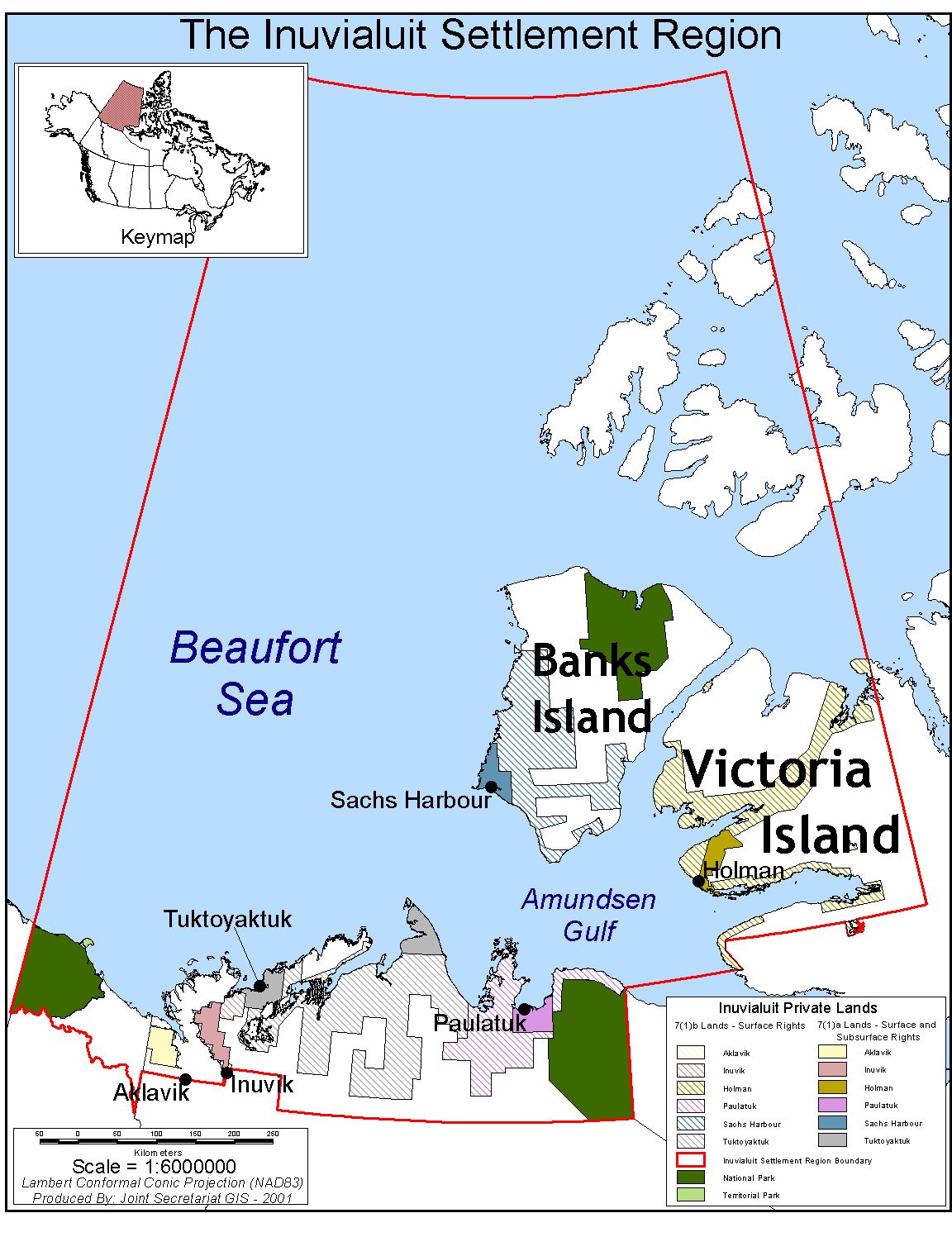
View on WikipediaThe Inuvialuit (sing. Inuvialuk; 'the real people'[5]) or Western Canadian Inuit are Inuit who live in the western Canadian Arctic region. They, like all other Inuit, are descendants of the Thule who migrated eastward from Alaska.[6] Their homeland – the Inuvialuit Settlement Region – covers the Arctic Ocean coastline area from the Alaskan border, east through the Beaufort Sea and beyond the Amundsen Gulf which includes some of the western Canadian Arctic Islands, as well as the inland community of Aklavik and part of Yukon.[7][8] The land was demarked in 1984 by the Inuvialuit Final Agreement.
Key Information


History and migration
[edit]

| Inu- ᐃᓄ- / nuna ᓄᓇ "person" / "land" | |
|---|---|
| Person | Inuvialuk |
| People | Inuvialuit |
| Language | Inuvialuktun |
| Country | Inuvialuit Nunangit (part of Inuit Nunangat) |
The Inuvialuit Settlement Region was primarily inhabited by Siglit Inuit until their numbers were decimated by the introduction of new diseases in the second half of the 19th century. Nunamiut, Alaskan Iñupiat, moved into traditional Siglit areas in the 1910s and 20s, enticed in part by renewed demand for furs from the Hudson's Bay Company and European markets. The Nunamiut who settled in the Siglit area became known as Uummarmiut. Originally, there was an intense dislike between the Siglit and the Uummarmiut, but these differences faded over the years, and the two aboriginal peoples intermarried. With improved healthcare and Nunatamiut intermarriage, the Inuvialuit now number approximately 3,100.[1][2]
In the 1930s, the Inuvialuit were involved in a Canadian government scheme to introduce reindeer herding as the primary economic driver of the Western Arctic. At tremendous expense, thousands of domesticated animals were herded from Alaska to the new Mackenzie Delta community of Reindeer Station. Indigenous Sámi people were brought from Norway to teach Inuvialuit men how to care for their own individual herds. However, the program was relatively unsuccessful, as it required a lonely lifestyle and was less lucrative than traditional hunting and trapping.[9]
The Inuvialuit Settlement Region Traditional Knowledge Report of 2006 identified additional naming characteristics. Those Inuvialuit who live in the west are called Ualinirmiut (Ualiniq) by the people of the east. The Inuvialuit who occupy the east are known as Kivaninmiut (Kivaliniq) by the people of the west.[10]
The Inuit of Ulukhaktok are neither Siglit nor Uummarmiut but are Copper Inuit and refer to themselves as Ulukhaktokmuit after Ulukhaktok, the native name for what used to be called Holman.
The proposed Mackenzie Valley Pipeline would have passed through both Inuvialuit and Gwichʼin territory before the abandonment of the project in 2017.
Language
[edit]The traditional language is known as Inuvialuktun and it is made up of three or four dialects. Uummarmiutun, spoken by the Uummarmiut of Aklavik and Inuvik, is an Iñupiaq dialect but is usually associated with Inuvialuktun. Sallirmiutun (formerly Siglitun) is spoken by the Siglit of Sachs Harbour, Paulatuk, Tuktoyaktuk and Inuvik. Kangiryuarmiutun is used by the Kangiryuarmiut of Ulukhaktok. Kangiryuarmiutun is essentially the same as Inuinnaqtun which is also used in the Nunavut communities of Kugluktuk, Bathurst Inlet and Cambridge Bay. Natsilingmiutut used by the Netsilik of Gjoa Haven, Taloyoak, Kugaaruk and Naujaat in Nunavut. Uummarmiutun, Siglitun and Inuinnaqtun (Kangiryuarmiutun) are all written using Latin script while Natsilingmiutut is written in Inuktitut syllabics.[3][11]
Culture
[edit]| Part of a series on |
| Indigenous peoples in Canada |
|---|
 |
 Indigenous North Americas Indigenous North Americas.svg) Canada portal Canada portal |
Kitigaaryuit is a former Inuvialuit settlement. It was the traditional territory of the Kitigaaryungmiut. The site, which is situated near the junction of the Mackenzie River's East Channel and Kugmallit Bay, encompasses the villages of Kitigaaryuk and Tchenerark, which are located on a small island, and the adjacent village of Kuugaatchiaq, located on the mainland to the west of the island.[12][13]
Herschel Island, which is uninhabited, is part of the ISR although in Yukon and was traditionally occupied and used by the Inuvialuit.[14] The island is an important part of Inuvialuit culture and the people still visit the island to hunt and fish.[14] At one time Herschel Island was inhabited by Paleo-Eskimo groups followed by Thule people, and finally the Inuvialuit, but in the latter half of the 20th century the population had migrated to government communities in the NWT.[14]
Tarium Niryutait, is a marine protected area (MPA) located in the coastal areas of the Yukon and Northwest Territories in Canada. It is located within the ISR and was the first Arctic MPA established in Canada. The MPA was established with the goal of protecting beluga whales and the biodiversity of other bird and fish species and their habitats.[15]
Year-round, Inuvialuit hunt caribou from the Cape Bathurst and Bluenose herds, and have also shared the Porcupine herd with the Gwichʼin. There has been some tension between the Inuvialuit and the Gwichʼin over caribou hunting.[16] Other activities are seasonal:[17]
- Spring: fishing, geese hunting, grizzly hunting
- Summer: whaling, fishing, gathering berries, roots and medicinal plants
- Autumn: fishing, sealing, geese hunting, and plant gathering
- Winter: fishing, sealing, polar bear hunting
Traditional Inuit games include:[18]
- akimuq: high kick game
- ayahaaq: string game
- iglukisaaq: juggling rocks
- mak: played by trying to make a person laugh
- napataak: darts; played with a wooden handle and sharp nail
Communities
[edit]
Inuvik, located on the East Channel of the Mackenzie Delta, approximately 100 km (62 mi) from the Arctic Ocean, is the region's administrative centre, home to the Inuvialuit Regional Corporation. The only other inland community, Aklavik, is located on the Peel Channel.
Hunting, fishing and trapping are the major economic activities of Paulatuk, in Amundsen Gulf's Darnley Bay, and Sachs Harbour, the only permanent settlement on Banks Island.
Tuktoyaktuk, formerly known as "Port Brabant",[19] is set on Kugmallit Bay, near the Mackenzie River Delta. It has the only deepwater port in the ISR.
Ulukhaktok, formerly known as "Holman", is located on the west coast of Victoria Island. Printmaking has taken over as the primary source of income in recent years.
| Community[20] | Traditional name[20] | Electoral district | Population (2021 Canadian census)[1][2] | ||||||||
|---|---|---|---|---|---|---|---|---|---|---|---|
| Total 2021 |
Total 2016 |
% change | Inuvialuit | % of total | First Nations | Métis | Multiple Indigenous[b] |
Non Indigenous | |||
| Aklavik | Akłarvik[c] | Mackenzie Delta | 536 | 590 | -9.2% | 320 | 59.7% | 130 | 25 | 15 | 45 |
| Inuvik | Inuuvik[d] | Boot Lake / Twin Lakes | 3,137 | 3,243 | -3.3% | 1,265 | 40.3% | 520 | 115 | 95 | 1,070 |
| Paulatuk | Paulatuuq[e] | Nunakput | 298 | 265 | 12.5% | 270 | 90.6% | 0 | 0 | 0 | 15 |
| Sachs Harbour | Ikaahuk[f] | Nunakput | 104 | 103 | 1.0% | 95 | 91.3% | 0 | 0 | 0 | 10 |
| Tuktoyaktuk | Tuktuujaqrtuuq[g] | Nunakput | 937 | 898 | 4.3% | 815 | 87% | 10 | 0 | 95 | 70 |
| Ulukhaktok | Ulukhaqtuuq[h] | Nunakput | 408 | 396 | 3.0% | 380 | 93.1% | 0 | 0 | 0 | 20 |
The area covered by the Inuvialuit Settlement Region is 435,000 km (270,000 mi), including 90,650 km2 (35,000 sq mi) of land and 12,980 km2 (5,010 sq mi) of subsurface mineral rights.[21] Aklavik (Aklavik First Nation, Ehdiitat Gwich'in Council) and Inuvik (Inuvik Native Band, Nihtat Gwich'in Council) are shared with the Gwichʼin people, who are represented by the Gwich'in Tribal Council.[22]
Notes
[edit]- ^ One of the official languages of the Northwest Territories.[4]
- ^ Includes Indigenous responses and those not included elsewhere.
- ^ Barrenground grizzly place
- ^ Place of man
- ^ Place of coal
- ^ Place to which you cross
- ^ Looks like a caribou. Formerly known as Port Brabant, it became the first community in Canada to reclaim its original name.[19]
- ^ Where there is material for ulus. Renamed from Holman on 1 April 2006
References
[edit]- ^ a b c "Census Profile, 2021 Census of Population Profile table - Aklavik, Paulatuk, Sachs Harbour, Tuktoyaktuk, Ulukhaktok, Hamlet (HAM) Northwest Territories [Census subdivision],". Statistics Canada. 2 August 2024. Retrieved 9 April 2025.
- ^ a b c "Census Profile, 2021 Census of Population Profile table - Inuvik, Town (T) Northwest Territories [Census subdivision]". Statistics Canada. 2 August 2024. Retrieved 9 April 2025.
- ^ a b "Inuvialuktun Dialects". Inuvialuit Regional Corporation. Retrieved 9 April 2025.
- ^ "Official Languages". Government of the Northwest Territories, Education, Culture and Employment. Retrieved 9 April 2025.
- ^ "Modern Inuvialuit Culture". Archived from the original on 2011-07-13. Retrieved 2012-06-01.
- ^ "The Thule". Archived from the original on 2014-12-13. Retrieved 2012-06-01.
- ^ Map of the Inuvialuit Settlement Region
- ^ Map of the Inuvialuit Settlement Region including communities
- ^ "1935 Reindeer Herding in the Northwest Territories". NWT Timeline. Prince of Wales Northern Heritage Centre. Retrieved 22 February 2021.
- ^ "Inuvialuit Settlement Region Traditional Knowledge Report" (PDF). ngps.nt.ca. August 2006. p. 45. Retrieved 2009-03-16.
- ^ Iñuvialuktun/Inuvialuktun/Inuinnaqtun / ᐃᓄᐃᓐᓇᖅᑐᓐ
- ^ Hart, Elisa (2015). "Kitigaaryuit (Kittigazuit)". The Canadian Encyclopedia. Archived from the original on 29 November 2021. Retrieved 29 November 2021.
- ^ Friesen, T. Max (2004). "Kitigaaryuit: A Portrait of the Mackenzie Inuit in the 1890s, Based on the Journals of Isaac O. Stringer". Arctic Anthropology. 41 (2): 222–237. doi:10.1353/arc.2011.0050. JSTOR 40316630. S2CID 163091888.
- ^ a b c Friesen, Max (1998). "Qikiqtaruk: Inuvialuit Archaeology on Herschel Island" (PDF). Government of Yukon - Heritage Branch. p. 2, 7, 19. ISBN 1550188046. Retrieved 9 April 2025.
- ^ "Tarium Niryutait Marine Protected Area (TN MPA)". www.dfo-mpo.gc.ca. Fisheries and Oceans Canada. 23 September 2019. Retrieved 2 June 2023.
- ^ "Gwich'in step up measures to protect Porcupine herd". CBC.ca. 2006-09-13. Retrieved 2007-07-23.
- ^ Inuvialuit Settlement Report (2006), p. 62
- ^ Inuvialuit Settlement Report (2006), p. 60
- ^ a b "Welcome to the Hamlet of Tuktoyaktuk Website". Retrieved 9 April 2025.
- ^ a b "Official NWT Community Names" (PDF). Education, Culture and Employment. Government of the Northwest Territories. Retrieved 9 April 2025.
- ^ "Concluding and Implementing Land Claim and Self-Government Agreements". Government of Northwest Territories. Retrieved 2 March 2018.
- ^ Gwich’in Tribal Council
External links
[edit]
- The Inuvialuit
- Inuvialuit Development Corporation
- Morrison, David. "Retracing an Archaeological Expedition. The Inuvialuit". Canadian Museum of Civilization Corporation.

| National | |
|---|---|
| Other | |

Inuvialuit
View on GrokipediaOrigins and Historical Development
Prehistoric Settlement and Migration Patterns
The direct ancestors of the Inuvialuit, part of the Thule culture (also termed proto-Inuit or Neo-Eskimo), emerged in coastal Alaska around 1000 CE and expanded eastward across the Arctic, arriving in the western Canadian Arctic, including the Mackenzie Delta and Amundsen Gulf regions, by approximately 1200 CE.[9] [10] This rapid migration followed marine mammal routes, particularly bowhead whales, and was enabled by technological superiority over preceding Paleo-Inuit groups like the Dorset culture, whose sparse occupations in the Mackenzie Delta dated back roughly 3000 years earlier but left limited archaeological traces due to coastal erosion and abandonment by around 1000 CE.[11] [2] Key sites, such as Cache Point in the Mackenzie Delta, reveal early Thule semi-subterranean winter houses, whalebone structures, and tool assemblages indicating year-round adaptation to coastal resources, contrasting with the more terrestrial focus of Dorset predecessors in the region.[12] Archaeological evidence from Thule sites across the Beaufort Sea coast and Mackenzie Delta documents settlement patterns tied to seasonal resource availability, with clusters of house pits near estuary mouths for spring whaling and interior sites for caribou procurement during migrations.[13] These patterns reflect a self-sustaining economy reliant on sea ice travel and hunting, supported by innovations like skin-covered umiaks for communal whale hunts, kayaks for individual seal pursuits, and toggling harpoons with stone or bone heads—technologies imported from Alaska and refined for western Arctic conditions, enabling exploitation of large marine mammals unavailable to earlier cultures.[14] Inuvialuit oral histories corroborate this, recounting ancestral groups' movements from Alaskan origins westward then eastward along whale migration paths, with periodic relocations driven by caribou herd fluctuations and beluga concentrations in delta channels, fostering distinct regional subgroups like the Siglit centered on the Mackenzie estuary.[2] [15] Unlike eastern Inuit migrations, which encountered denser Dorset holdouts and required further adaptation to open-water polynyas, Inuvialuit ancestral patterns emphasized stable coastal-riverine circuits in a relatively depopulated western Arctic, promoting continuity through climate-responsive mobility rather than large-scale displacement.[10] This empirical record of habitation, spanning semi-permanent villages and transient camps, underscores long-term environmental adaptation without evidence of overexploitation, as indicated by sustained faunal remains in middens from sites like those in the delta.[16]European Contact and Early Trade Dynamics
The first documented European contacts with the Inuvialuit occurred in the early to mid-19th century, primarily through indirect trade networks extending from Russian posts in Alaska, though direct interactions began with the arrival of American and Scottish whalers in the Beaufort Sea during the 1850s and intensified after the 1880s.[17][18] These whalers established seasonal shore stations, such as on Herschel Island by 1889, exchanging baleen, ivory, and furs for manufactured goods including firearms, metal tools, cloth, and tobacco, which initially enhanced hunting efficiency by enabling the harvest of larger game like bowhead whales and caribou.[19] However, this trade also facilitated overhunting of local resources, as rifles depleted caribou herds and intensified competition for fox furs, contributing to ecological strain in coastal territories.[20] By the early 20th century, the Hudson's Bay Company formalized fur trade dynamics with the Inuvialuit, establishing posts such as Aklavik in 1912 and Kittigazuit to capture white fox and muskrat pelts, drawing nomadic groups into semi-sedentary patterns around these fixed locations for reliable access to trade.[21][22] European goods like flour, tea, and ammunition altered traditional diets, fostering dependencies that reduced reliance on solely subsistence hunting and fishing while introducing nutritional shifts toward carbohydrate-heavy imports.[23] Contact precipitated severe demographic declines through introduced diseases, with epidemics of measles, influenza, and smallpox ravaging communities; a particularly devastating smallpox outbreak in 1902 caused high mortality rates, reducing the Inuvialuit population from an estimated 1,800 in the late 19th century to around 150 in affected Yukon North Slope areas by 1905, representing losses exceeding 90% in some locales due to lack of immunity.[20][24] These impacts, compounded by earlier outbreaks in 1868–1871 and 1900, shifted social structures toward smaller, post-centered bands, undermining traditional mobility and kinship networks without corresponding population recovery until mid-20th-century interventions.[20]Modern Era: Land Claims and Political Negotiations
In 1970, Inuvialuit leaders established the Committee for Original People's Entitlements (COPE) to represent their interests in land claims and resource rights in the western Arctic, distinct from other Indigenous groups in the Northwest Territories.[25] COPE's formation reflected a strategic decision to pursue separate negotiations rather than merging with the Dene and Métis claims under the broader Dene Nation framework, enabling focused assertion of Inuvialuit-specific entitlements over traditional territories.[26] Negotiations with the Government of Canada commenced following COPE's submission of a comprehensive land claim in 1977 on behalf of approximately 4,500 Inuvialuit, addressing historical federal delays in recognizing Aboriginal title amid resource development pressures. After a decade of talks, the Inuvialuit Final Agreement (IFA) was signed on June 5, 1984, marking the first comprehensive land claim settlement north of the 60th parallel.[27] The agreement provided fee simple title to roughly 91,000 square kilometers of land, including subsurface rights over 13,000 square kilometers, alongside financial compensation totaling $52 million paid over 14 years to support economic development.[28][29] The IFA secured preferential and exclusive wildlife harvesting rights for Inuvialuit across the Inuvialuit Settlement Region, subject to conservation measures co-managed through bodies like the Inuvialuit Game Council, countering prior assimilation-era disruptions such as residential schools that impacted a substantial share of Indigenous youth in the region.[30][31] Provisions for participation in resource revenue from non-renewable developments and capital transfers facilitated Inuvialuit-led initiatives, including the establishment of the Inuvialuit Regional Corporation to administer settlement benefits and promote self-reliance.[32] While federal negotiation tactics prolonged the process and required concessions on certain subsurface interests, the agreement's emphasis on Inuvialuit agency in wildlife and land management yielded long-term control over traditional practices and economic opportunities.[33]Language and Linguistic Heritage
Structure and Dialects of Inuvialuktun
Inuvialuktun is classified within the Inuit branch of the Eskimo-Aleut language family, which encompasses languages spoken across Arctic regions from Alaska to Greenland.[34] This branch shares common typological features with other Inuit varieties, including a phonological inventory typically comprising 15 consonants and three vowel qualities distinguished by length. Inuvialuktun consists of three primary dialects—Uummarmiutun, Kangiryuarmiutun, and Sallirmiutun—each associated with specific Inuvialuit communities in the western Canadian Arctic, such as those around Inuvik, Tuktoyaktuk, and Sachs Harbour.[3][35] These dialects exhibit phonological variations, including differences in sibilant pronunciation (e.g., s versus h sounds) and vowel shifts that distinguish them from eastern Inuit languages like Inuktitut.[36] Grammatically, Inuvialuktun is polysynthetic, incorporating roots, affixes, and incorporations into single complex words that convey entire propositions, a trait common to Eskimoan languages for efficient expression in oral traditions.[37] It employs an ergative-absolutive alignment, where subjects of transitive verbs take ergative case marking while subjects of intransitive verbs and objects of transitives remain in the absolutive.[38] The language features an extensive case system, with up to eight cases including locative, ablative, and allative forms that encode precise spatial relations, reflecting adaptations to Arctic navigation and hunting where directionality relative to sea ice and land is critical.[39] Historical documentation of Inuvialuktun began with 19th-century explorer records, such as those from whalers and missionaries who transcribed oral narratives, providing early lexical data tied to the environment.[40] Modern orthographic standardization emerged in the late 20th century, adopting a Roman-based script in the 1980s to facilitate literacy and distinguish it from syllabic systems used in eastern dialects; this system, refined through community consultations, uses digraphs like "ng" for velar nasals and "rl" for retroflex laterals.[41] Vocabulary reflects environmental specificity, with dozens of terms delineating snow and ice types—such as qanik for falling snow crystals and aput for snow on the ground—enabling nuanced descriptions of conditions essential for subsistence activities, though exact counts vary by dialect and documentation.[42][43]Current Usage, Revitalization Efforts, and Decline Factors
In the 2021 Canadian Census, 330 individuals reported the ability to speak Inuvialuktun, with 83.3% residing in the Inuvialuit Settlement Region of the Northwest Territories; this represents a small fraction of the approximately 5,000 Inuvialuit population, indicating low overall fluency estimated at around 10% who can speak any form of the language to varying degrees.[44][45] Fluency remains concentrated among elders in rural communities such as Tuktoyaktuk and Paulatuk, where daily use persists in informal settings, while younger generations in urban centers like Inuvik exhibit near-total attrition.[46] Historical data from the Inuvialuit Cultural Resource Centre suggest a steeper decline from higher proficiency levels in the 1970s, when intergenerational transmission was more intact prior to intensified external pressures.[47] Key factors contributing to the decline include the legacy of residential schools, which forcibly separated children from families and prohibited Inuvialuktun use, severing oral transmission chains that are essential for language acquisition in Inuit contexts.[48] This disruption compounded with the shift to a wage-based economy in the post-World War II era, where English proficiency became a prerequisite for employment in resource extraction and government roles, prioritizing economic adaptation over linguistic continuity.[49] Urban migration to hubs like Inuvik further eroded usage, as mixed-language environments and media exposure favored English, leading to passive comprehension among youth but rare active production; empirical patterns show retention rates up to twice as high in remote settlements versus urban areas, underscoring isolation's protective role against assimilation.[50] Revitalization initiatives, primarily led by the Inuvialuit Regional Corporation (IRC) through its Inuvialuit Cultural Centre established in 1998, focus on immersion programs, digital apps, and dialect-specific curricula for the three variants: Uummarmiutun, Kangiryuarmiutun, and Iñuvialuktun.[45][51] Federal funding supported a 2020 immersion pilot in NWT communities, aiming to integrate Inuvialuktun into early education, yet outcomes remain limited, with participation rates below 20% in targeted schools due to persistent gaps in parental fluency and competing demands from standard English curricula.[52] Debates persist on mandatory policies, such as requiring Inuvialuktun credits for graduation, with proponents citing modest gains in Nunavut's Inuktitut models but critics noting enforcement challenges and potential backlash in English-dominant job markets; IRC evaluations indicate apps and community workshops have boosted awareness but failed to reverse transmission breakdowns without broader familial reinforcement.[53]Traditional Culture and Social Organization
Subsistence Practices and Environmental Adaptation
The Inuvialuit have historically depended on a mixed subsistence economy centered on hunting marine mammals, caribou, and fish, adapted to the seasonal rhythms of the Western Canadian Arctic. Primary activities include beluga whaling in spring along the Beaufort Sea coast, caribou hunting during migrations, and trapping ringed seals year-round, supplemented by fishing for Arctic char and whitefish.[54][55] These pursuits supported small, mobile groups through seasonal relocation to hunting camps, such as those near the Mackenzie River delta for beluga harvests, enabling efficient resource exploitation amid ice breakup and animal movements.[56][20] Beluga whaling remains a cornerstone, with subsistence harvests averaging 96 whales annually in the Inuvialuit Settlement Region from 2000 to 2012, levels deemed sustainable under co-management agreements informed by traditional knowledge and scientific monitoring.[57] This practice traces back over 700 years without evidence of population depletion, as genetic and isotopic analyses of archaeological remains indicate stable foraging ecology and harvest impacts insufficient to alter beluga demographics significantly.[9] Caribou and seal hunting provided diversified protein sources, with seals targeted using harpoons from kayaks during open water seasons.[58][55] Environmental adaptations featured specialized technologies for Arctic extremes. Hunters employed skin-covered kayaks for agile pursuit of seals and umiaks—larger open boats—for communal whaling and transport, facilitating coastal navigation amid variable ice conditions.[59] Temporary snow domes (igloos) served as insulated shelters during travels, leveraging compacted snow's thermal resistance to maintain habitable interiors against sub-zero temperatures, comparable to modern insulation values.[60] Food caching in elevated platforms or buried pits preserved meats and fish through winter scarcity, preventing spoilage via permafrost refrigeration.[61] Pre-contact diets derived predominantly from animal sources, with marine mammals comprising a major portion—often exceeding 50% of caloric intake in coastal groups—yielding high omega-3 fatty acids essential for metabolic adaptation to cold and fat-based energy needs.[62][63] This nutritional profile, rich in eicosapentaenoic and docosahexaenoic acids from blubber and muktuk, supported population viability through efficient energy storage and cardiovascular resilience, as evidenced by ethnographic records and biochemical studies of traditional foods.[64][65] Diversification across species mitigated risks from environmental variability, underscoring causal links between habitat-specific strategies and long-term subsistence sustainability.[9]Kinship Systems, Governance, and Spiritual Beliefs
The Inuvialuit maintained a bilateral kinship system emphasizing extended family networks, with social organization revolving around small, autonomous kin-based bands of approximately 20-30 members who collaborated on subsistence activities like hunting and seasonal migrations.[18] These bands, often comprising multiple related households, promoted resource sharing and mutual aid crucial for survival in the harsh Arctic environment, with intermarriage extending ties to neighboring Inupiat and Gwich'in groups.[18] Customary adoption practices further reinforced these networks by redistributing children to ensure elder care and population stability.[66] Disputes within bands were addressed through informal consensus among members, prioritizing collective harmony over punitive measures or centralized authority.[18] Pre-contact governance lacked formal hierarchies or chiefs; instead, influence derived from skilled hunters and elders whose expertise in navigation, hunting techniques, and environmental knowledge guided group decisions during gatherings or crises.[18] This pragmatic leadership structure supported adaptive responses to resource variability without rigid power structures. Inuvialuit cosmology centered on an animistic worldview, where natural phenomena, animals, and landscapes were imbued with spirits influencing human affairs.[67] Shamans, known as angakkuq, functioned as mediators between the physical and spiritual realms, employing rituals for weather prediction, diagnosing and healing ailments linked to spirit disequilibrium, and averting taboos that could disrupt hunting success—roles corroborated by early 20th-century ethnographic observations of practices like the Dance of the Loons.[68] These activities emphasized causal mechanisms for environmental control rather than abstract mysticism, with shamans selected through demonstrated spiritual aptitude. Christianity's arrival via Anglican missions around 1907 prompted a transition, with initial baptisms recorded in 1909 on Herschel Island and broader conversions accelerating in the 1920s as missionaries integrated with communities.[23][18] This shift diminished shamanic authority by the mid-20th century, though traditional oral lore persisted for ethical instruction and cultural continuity alongside predominant Christian affiliation today.[68][18]Contemporary Communities and Demographics
Key Settlements and Population Distribution
The Inuvialuit Settlement Region (ISR) encompasses six primary communities: Inuvik, Tuktoyaktuk, Aklavik, Paulatuk, Sachs Harbour, and Ulukhaktok, spanning approximately 90,650 square kilometers in the western Canadian Arctic.[69] In the 2021 Census, the ISR's total population stood at 5,420, with 3,145 individuals self-identifying as Inuit, representing about 58% of residents and concentrated primarily in the smaller coastal and island settlements. Approximately 60% of Inuvialuit beneficiaries reside within the ISR, reflecting a geographic focus amid broader beneficiary distribution across Canada.[70] Key demographic metrics highlight a youthful profile, with roughly 30% of the Inuvialuit population under age 15, consistent with broader Inuit trends of higher fertility rates and lower median ages compared to the Canadian average.[71] Gender distribution remains relatively balanced, with near parity across age groups in census data. Community compositions vary: Inuvik, the regional hub with a 2021 population of 3,243, features a mixed demographic including about 40% Inuvialuit alongside non-Indigenous and other Indigenous groups.[72] [73] Tuktoyaktuk (population 981) is predominantly Inuvialuit, exceeding 80% Inuit identity, while Aklavik (656) blends Inuvialuit with Gwich'in First Nations.[74] Smaller settlements like Paulatuk (294), Sachs Harbour (118), and Ulukhaktok (415) maintain higher proportions of Inuvialuit residents, often over 90%, preserving more homogeneous ethnic distributions.[74]| Community | Total Population (2021 Census) | Primary Composition Notes |
|---|---|---|
| Inuvik | 3,243 | Mixed; ~40% Inuvialuit, diverse Indigenous and non-Indigenous[72] |
| Tuktoyaktuk | 981 | Predominantly Inuvialuit (>80%)[74] |
| Aklavik | 656 | Mixed Inuvialuit and Gwich'in[72] |
| Paulatuk | 294 | Majority Inuvialuit[74] |
| Sachs Harbour | 118 | Majority Inuvialuit[74] |
| Ulukhaktok | 415 | Majority Inuvialuit[74] |