Hubbry Logo
Loch ArkaigLoch ArkaigMain
Open search
Loch Arkaig
Community hub
Loch Arkaig
logo
8 pages, 0 posts
0 subscribers
Be the first to start a discussion here.
Loch Arkaig
Loch Arkaig
from Wikipedia

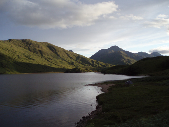
Loch Arkaig (Scottish Gaelic: Loch Airceig) is a body of freshwater in Lochaber, Scotland, to the west of the Great Glen. It is approximately 12 miles (19 kilometres) in length and lies 140 feet (43 metres) above sea level, and the maximum depth is around 300 feet (90 metres). The loch is among the last remaining fragments of the Caledonian pinewood, which is native to the UK.[1]

Key Information

The main tributaries are the Dessarry and the Pean, which flow through the glens of the same names, falling into the loch at the extreme west end, by the settlement of Strathan. The mountains of Lochaber lie to the north, and the Forest of Locheil to the south. The outflow is through the River Arkaig at the extreme southeast of the loch, which flows eastwards 1+38 miles (2.2 kilometres) to Loch Lochy, passing Achnacarry.

Two small islands lie at the eastern end of the loch, the larger of which, Island Columbkill, or Eilean Loch Airceig, is the site of a ruined chapel dedicated to St Columba which is the former burial ground of the Camerons of Locheil. A road from the Great Glen follows the north shore of the loch to Strathan where paths lead on to Knoydart, Glenfinnan and Loch Morar.

The River Arkaig flows from the eastern end of Loch Arkaig.

In 1746, Jacobite funds were said to have been hidden here (see Loch Arkaig treasure).

In common with a number of other Scottish lochs, Loch Arkaig was at one time supposed to be the home of a water horse. James Harris, 3rd Earl of Malmesbury and twice foreign minister during Queen Victoria's reign, recorded in his Memoirs of an Ex-Minister:

"October 3rd, 1857. This morning my stalker and his boy gave me an account of a mysterious creature, which they say exists in Loch Arkaig, and which they call the Lake-Horse. It is the same animal of which one has occasionally read accounts in newspapers as having been seen in the Highland lochs, and of the existence of which in Loch Assynt the late Lord Ellesmere wrote an interesting article, but hitherto the story has always been looked upon as fabulous. I am now, however, nearly persuaded of its truth. My stalker, John Stuart, at Achnacarry, has seen it twice, and both times at sunrise on a bright sunny day, when there was not a ripple on the water. The creature was basking on the surface; he only saw the head and hind quarters, proving that its back was hollow, which is not the shape of any fish or of a seal. Its head resembled that of a horse.... The Highlanders are very superstitious about this creature. They are convinced that there is never more than one in existence at the same time, and I believe they think it has something diabolical in its nature, for when I said I wished I could get within shot of it, my stalker observed very gravely: 'Perhaps your Lordship's gun would miss fire.'"[2]

References

[edit]
[edit]
Revisions and contributorsEdit on WikipediaRead on Wikipedia
from Grokipedia
Loch Arkaig is a large, deep freshwater loch in the district of the , extending approximately 12 miles (19 km) in an east-west direction and reaching a maximum depth of around 300 feet (90 m), situated 140 feet (43 m) above . Located about 10 miles (16 km) north of Fort William and west of the , it is a glacial feature flanked by ancient Caledonian forests, native broadleaf woodlands, and steep mountains that rise dramatically on both shores. The loch's surrounding landscape forms part of Scotland's Atlantic rainforest zone, characterized by wet, wild terrain that supports a diverse array of habitats including moorland, freshwater lochs, and remnant native pinewoods covering over 1,000 hectares. This environment is home to iconic wildlife such as golden eagles, white-tailed sea eagles, ospreys (with nesting sites monitored via live cameras from March to September), pine martens, red squirrels, otters, badgers, red deer, and wild boar, alongside rare species like the chequered skipper butterfly, azure hawker dragonfly, and specialized lichens and bryophytes such as ostrich plume moss and lungwort. Conservation efforts, led by organizations like the Woodland Trust since their 2016 acquisition of key forest areas, focus on restoring native Scots pine, oak, birch, and other species while removing non-native conifers planted in the mid-20th century, ensuring protection during bird breeding seasons from April to August. Historically, Loch Arkaig holds significance in Jacobite lore, particularly as a refuge for Prince Charles Edward Stuart following the in 1746, when he reportedly wandered the area and French-supplied gold intended for the Jacobite cause was allegedly hidden nearby, with treasures rumored to remain undiscovered. The loch was once enveloped by expansive oak and pine forests that supported local clans like the Camerons of Lochiel, whose burial ground lies on a ruined islet, and a fort was constructed near Kinlocharkaig in the to control the region. In the , the area saw impacts from use, including a 1942 fire during training that destroyed native trees, followed by plantations that are now being reversed to revive the . Today, the loch offers limited public access via minor roads from the A82 near , with permitted from 15 March to 6 October, emphasizing its role as a remote, protected natural and cultural treasure.

Geography

Location and Dimensions

Loch Arkaig is situated in the Highland region of Lochaber, Scotland, within the Great Glen area of the Western Highlands. Its central coordinates are approximately 56.966°N 5.134°W. The loch lies in a remote, rugged landscape, extending westward from near the eastern end of Loch Lochy. The loch measures about 19 km (12 miles) in length and is oriented roughly east-west along a narrow, elongated valley. It has a surface area of approximately 16 km² (6.2 sq mi). At an elevation of 43 m (141 ft) above sea level, Loch Arkaig is relatively low-lying for a Highland freshwater body. Historical bathymetrical surveys, including the comprehensive effort by Sir John Murray and Laurence Pullar as part of the Bathymetrical Survey of the Fresh-Water Lochs of Scotland, reveal a deep, irregular basin typical of glaciated terrain. The maximum depth reaches 109.4 m (359 ft), with an average depth of 46.5 m (153 ft), indicating a steep-sided profile that steepens toward the western end. Loch Arkaig originated as a post-Ice Age glacial feature, carved by erosive action of ice sheets during the Pleistocene, particularly the Devensian glaciation, which scoured pre-existing valleys in the Western Highlands to form deep, linear basins like this .

Hydrology

Loch Arkaig receives its primary inflows from the River Dessary, which drains Glen Dessary to the north, and the River Pean, which drains Glen Pean to the south; both rivers converge and enter the loch at its western end near Strathan. The River Dessary flows westerly for approximately 10 km through rugged terrain before joining the Pean. These inflows contribute to the loch's role as a key component in the regional watershed, channeling precipitation and runoff from the surrounding uplands. The loch's outflow occurs via the River Arkaig, which exits at the eastern end and flows eastward for about 3 km into Loch Lochy, part of the broader Lochy catchment system. This drainage pattern integrates Loch Arkaig into the network's hydrological framework, facilitating water movement toward the northeast. Loch Arkaig exhibits low , characteristic of many Highland freshwater bodies, supporting its oligotrophic nature with nutrient-poor, clear waters that maintain high transparency. Recent assessments by the Scottish Environment Protection Agency classify the loch at high ecological status, indicating minimal impairment from nutrients or pollutants and robust overall water quality. Water levels in Loch Arkaig fluctuate seasonally due to the high rainfall typical of Scotland's wet western , with elevated during autumn and winter leading to higher inflows and potential flooding risks. The loch's glacial origins provide depth that buffers extreme variations, promoting hydrological stability despite these climatic influences.

Surrounding Landscape

Loch Arkaig is nestled within a dramatic Highland landscape of the region, where steep mountains rise directly from the water's edge, interspersed with ancient woodlands and expansive moorlands. The loch's shores are framed by the mountainous terrain of to the north and the Forest of Locheil and Loch Arkaig Pine Forest to the south, creating a rugged terrain that transitions from dense tree cover to open, heather-clad hills. This mix of coniferous and broadleaf woodlands climbs the slopes of surrounding peaks, while boggy moorlands dominate higher elevations, contributing to a wild, glacially sculpted environment. The north shore follows a narrow, designated as the B8005, which extends approximately 19 kilometers from the hamlet of at the eastern end to the smaller settlement of Strathan at the western end. This road, branching off the A82 trunk road near , provides the primary access route and continues beyond Strathan via paths linking to and , facilitating exploration of the broader area. Flanked by birch woodlands and the undulating edges of the Forest of Locheil, the north shore offers views across to the more remote southern hills, with the terrain gradually ascending into the moorland-backed mountains of . In contrast, the south shore is largely inaccessible by road and remains one of the most remote sections of the loch, characterized by thickly forested slopes that give way to steep, grassy moorlands rising to elevations of around 500 meters. The southern part of the Loch Arkaig Pine Forest, including the Gusach block, borders this side and merges with open heath, providing informal tracks for foot access toward the Knoydart peninsula from the western reaches near Strathan. These southern forests, part of the ancient Caledonian pinewood remnants, border the wild, roadless expanse of Knoydart, enhancing the area's sense of isolation amid the encircling Lochaber peaks. The overall Loch Arkaig Pine Forest encompasses over 1,000 hectares divided into the Glen Mallie block on the north and the Gusach block on the south. Human presence in the landscape is minimal, limited to scattered hamlets such as —home to the historic Achnacarry Estate—and the tiny roadside community of Strathan, both situated along the north shore road. The loch's eastern approach lies in close proximity to the Commando Memorial, a prominent stone monument overlooking and the start of the B8005, which serves as a key gateway and viewpoint for the surrounding terrain. These features underscore the blend of natural remoteness and subtle human imprints in an otherwise untamed Highland setting.

Ecology

Flora

The flora of Loch Arkaig is dominated by fragments of native Caledonian pinewood, representing one of the United Kingdom's most significant remnants of this ancient forest type, which once covered much of the Scottish Highlands. These woodlands, covering over 1,000 hectares, feature open stands of Scots pine (Pinus sylvestris) as the primary canopy species, interspersed with broadleaved trees such as birch (Betula spp.), rowan (Sorbus aucuparia), and oak (Quercus petraea and Q. robur). The in these pinewoods is characterized by ericaceous shrubs and herbaceous plants adapted to acidic, nutrient-poor soils, including blaeberry (), heather (Calluna vulgaris), and various mosses that form dense carpets on the forest floor. Due to the region's high rainfall—exceeding 2,000 mm annually—the area supports elements of , with diverse lichens, ferns, and bryophytes (mosses and liverworts) epiphytically colonizing tree trunks, branches, and rocks. Species such as the lichen Usnea spp. and bryophytes like thrive in these moist, shaded microhabitats, contributing to the ecosystem's . These woodlands extend up the mountainsides on both shores of the loch, creating a continuous band of from the water's edge to elevations over 300 meters, though many fragments remain inaccessible except by boat due to the rugged terrain and remoteness. The Gusach woodland on the shore exemplifies this inaccessibility, preserving pristine stands with minimal human disturbance. This distribution fosters a mosaic of habitats that supports a range of associated .

Fauna

Loch Arkaig supports a diverse array of , largely dependent on its ancient Caledonian pinewood and surrounding mixed woodlands, which provide essential cover, food sources, and breeding sites for resident and migratory species. The loch is particularly renowned for its birdlife, including breeding pairs of ospreys (Pandion haliaetus) that have nested in the area since 2017 and are monitored via a live operated by the since 2017. Other notable raptors include white-tailed sea eagles (Haliaeetus albicilla) and golden eagles (Aquila chrysaetos), which nest in the pine forests and hunt over the water. Ground-dwelling birds such as (Tetrao tetrix) thrive in the open woodland edges, while common redstarts (Phoenicurus phoenicurus) arrive as spring migrants to breed in the mixed woodlands alongside species like wood warblers (Phylloscopus sibilatrix) and tree pipits (Anthus trivialis). Mammalian residents include red squirrels (Sciurus vulgaris), which rely on the pine seeds, and elusive pine martens (Martes martes) that den in tree hollows. Badgers (Meles meles) forage in the , while otters (Lutra lutra) frequent the loch shores and inflows. (Cervus elaphus) visit primarily in winter, drawn to the sheltered valleys, and a reclusive population of (Sus scrofa), descended from feral pigs, roams the forests. Sightings of the endangered (Felis silvestris) are possible but unconfirmed in the area. Aquatic life centers on salmonids, with Atlantic salmon (Salmo salar) ascending the River Arkaig inflows for spawning and brown trout (Salmo trutta), including large ferox strains, inhabiting the loch's depths. These fish form a key part of the , supporting piscivorous birds and sustaining invertebrate populations like aquatic larvae. Several bat species, including common pipistrelles (Pipistrellus pipistrellus), utilize the woodlands for roosting and foraging on insects. The surrounding clearings host butterflies such as the chequered skipper (Carterocephalus palaemon) and small pearl-bordered fritillary (Boloria selene), alongside dragonflies like the azure hawker (Aeshna caerulea). Over 900 insect species have been recorded, including wood ants (Formica spp.) and longhorn beetles, which underpin the ecosystem's .

History

Pre-Modern Period

The region surrounding Loch Arkaig shows evidence of early medieval Christian activity, particularly through the ruins of a dedicated to St Columba on Eilean Chalum Cille (also known as Island Columbkill), an islet near the loch's head. These remains, consisting of stone foundations and associated features, indicate a site of religious significance dating to the early medieval period. Loch Arkaig and its environs held strong historical ties to , a West Highland clan whose territories in the encompassed the loch's western shores, including Glen Loy and adjacent glens. , situated on the loch's northeastern bank, served as the longstanding seat of the Cameron chiefs, reinforcing the clan's influence over the area from at least the medieval era onward. Prior to the 18th century, the loch and its surrounding glens sustained pre-industrial livelihoods centered on fishing, forestry, and small-scale agriculture. Local inhabitants relied on the loch for trout and other freshwater fish, supporting subsistence needs in this remote Highland setting. The dense native woodlands of oak, pine, birch, and alder along the shores provided timber for construction and fuel, while the fertile lower slopes of the glens accommodated pastoral grazing and limited crop cultivation. Archaeological evidence highlights ancient human activity, including trackways and abandoned that underscore settlement patterns before widespread clearances. Sunken holloways and paths, such as those near the western end of the , facilitated movement and herding across the rugged terrain. The of Ard Nois, now reduced to moss-covered ruined walls amid former pasture and , exemplifies these early communities, with structures suggesting occupation tied to agricultural and forestry pursuits.

Jacobite Era

During the , Loch Arkaig became a pivotal site in the aftermath of the on April 16, 1746, when French aid in the form of arrived to support the faltering cause. In late April 1746, two French ships, the Bellona and Mars, landed approximately 35,000 (valued at around £35,000 sterling) at on the west coast of , along with arms and supplies. This shipment, dispatched by King , was intended to finance Jacobite resistance and aid fleeing supporters, but much of it was transported inland and concealed near the shores of Loch Arkaig by John Murray of Broughton, a key Jacobite secretary who had been entrusted with its distribution. Murray buried the bulk of the treasure in several locations around the loch to evade government forces, though losses occurred immediately: around 800 were stolen during unloading, and Murray himself disbursed or misappropriated portions, including 4,200 given to various chiefs and 3,000 taken for personal use. Prince , the Young Pretender, passed through the Loch Arkaig area multiple times during his five-month flight from government pursuers after Culloden. On April 17, 1746, he rode via the loch from to Glenpean, seeking refuge among loyal supporters, before continuing on foot to Glen Morar. He returned to the vicinity in May 1746, staying near Corradale while aides like Donald MacLeod attempted to retrieve funds from Murray at Loch Arkaig, though unsuccessfully at first. By August, the prince sheltered at the loch for several days, meeting allies such as Lochgarry and Cameron of Clunes, and in September 1746, he reached Glencamger at the head of Loch Arkaig to rendezvous with Ewen Macpherson of , who had assumed control of the treasure's management after Murray's capture and defection. From there, proceeded to Borradale and escaped to France on September 19, taking 3,000 with him. Local Highland clans, particularly the Camerons under and the Macphersons led by , played central roles in safeguarding the area and the gold, providing shelter and logistics despite severe reprisals from Hanoverian forces. recovered and administered much of the remaining treasure, distributing about 24,000 by 1755 to support exiled Jacobites, including payments to the Lochiel family for their losses, though he personally expended 6,700 on relief efforts. Although all funds were ultimately accounted for, the concealment and partial losses contributed to economic hardships for the clans, as the funds were meant to rebuild estates forfeited after the rising; this led to disputes in the , such as between and the Cameron family. These events fueled persistent myths of , though documented recoveries confirmed substantial portions were used for Jacobite survival rather than lost entirely.

Folklore

Water Horse Legend

The each-uisge, or , is a central figure in the surrounding Loch Arkaig, depicted as a malevolent shape-shifting spirit that inhabits the loch's dark waters. Unlike the more playful associated with rivers, the each-uisge typically appears as a handsome horse with in its mane, enticing riders to mount it before galloping into the depths to drown and devour them, skin and bones alike. This creature is said to possess strength and adhesive skin that prevents escape once contact is made, embodying the dangers of the isolated Highland lochs. Historical accounts of the Loch Arkaig date back to at least the mid-19th century, when James Howard Harris, 3rd Earl of Malmesbury, recorded in his memoirs on October 3, 1857, that locals believed in water kelpies and described a emerging from the loch to devour people. During , when the surrounding area was used for Commando training, reports emerged from soldiers who observed a large, dark, horse-headed form moving swiftly through the water, nearly colliding with their boats; these incidents were later recounted by veterans to Loch Ness researcher Tim Dinsdale, fueling speculation that the creature's appearances were intensified by wartime activity and restricted access. Embedded in broader traditions, the Loch Arkaig legend reflects the cultural reverence and fear of deep, remote bodies of water, where the loch's maximum depth of over 100 meters (328 feet) and surrounding dense forests amplified tales of hidden perils and otherworldly guardians. Such myths served as cautionary narratives in Highland communities, warning against straying near hazardous waters. In contemporary interpretations, sightings of the are largely dismissed by skeptics as misidentifications of common wildlife like otters or seals, optical illusions from floating logs or waves, or, in historical contexts like WWII, actual training maneuvers mistaken for events. Despite scientific explanations, the legend endures in local and , preserving Loch Arkaig's mystique as a shared motif with other Scottish .

Treasure Myths

The legend of the Loch Arkaig treasure centers on a hoard of French coins, known as louis d'ors, dispatched to aid the Jacobite cause and allegedly buried in the dense pine forests surrounding the loch following the defeat at Culloden in April 1746. Consisting of up to seven wooden caskets containing approximately 15,000 coins—valued at around £35,000 at the time, equivalent to several million pounds today—the treasure was landed by French ships near Loch nan Uamh and transported inland for safekeeping by figures such as Dr. Archibald Cameron, who concealed portions near Callich Burn and in Glen Mallie. Intended to fund the escape of Jacobite supporters to sympathetic European nations, much of the vanished amid accusations of , with only small amounts documented as distributed or smuggled out, such as £6,000 taken to in 1748 by Donald Macpherson of Breachachie and Charles Selby. Prominent Jacobite leader Alastair Ruadh MacDonell of , known as " the Spy" for his dual role as informant, was deeply involved in the treasure's saga and rumored to have appropriated a share for personal use, including 1,200 louis d'ors alongside his kinsman Lochgarry in 1749. Disputes over the hoard fueled bitter rivalries, with accusing MacDonell of forgery and theft before his execution in 1753, while MacDonell countered by reporting Cameron's own withdrawals of 6,000 louis d'ors. These claims persisted through generations, leading to legal summonses against custodians like Euan Macpherson of in 1765, where his family defended the distribution of funds, and extending to protracted litigation among claimants until at least 1822, as heirs sought validation of their entitlements in Scottish courts. Alleged burial sites focused on secluded spots like the woods a mile and a half south of the loch's head near Kinlocharkaig or Achnacarry Castle, prompting unverified digs throughout the 19th and 20th centuries, including reports of scattered gold coins unearthed in the 1850s per records, though no major cache was confirmed. The treasure myth has profoundly influenced Scottish cultural narratives, romanticizing the Jacobite era's valor and betrayal in such as Nigel Tranter's 1969 novel Gold for Prince Charlie, which dramatizes the 's concealment, and inspiring modern expeditions like explorer Ashley Cowie's 2016 geophysical surveys around Loch Arkaig. In 2020, amateur archaeologists uncovered a small Jacobite-era of 215 balls, coins, and gilt buttons near a ruined croft in the area, but no significant cache. It embodies the broader allure of Jacobite romance, blending historical loss with tales of hidden fortune and clan loyalty. To this day, as of 2025, no verified discovery of the primary treasure has occurred, sustaining the legend through community initiatives like the Trust's Loch Arkaig Treasure Trail, a 7.5-mile path in the pine forest that guides visitors to interpretive sculptures evoking the caskets' hiding spots and the era's myths.

Conservation

Pine Forest Management

In 2016, the Woodland Trust acquired Loch Arkaig Pine Forest from Forest Enterprise Scotland under the National Forest Land Scheme, in partnership with Arkaig Community Forest, a local charity that co-manages the site to support community involvement in conservation. This acquisition encompassed approximately 1,045 hectares of ancient Caledonian pinewood, with the Woodland Trust holding the majority ownership and committing significant funding for restoration, including a £4 million program supported by public donations and grants. Restoration efforts have focused on enhancing native woodland through targeted planting of species such as Scots pine, oak, birch, rowan, hazel, aspen, alder, and juniper to bolster the forest's ecological structure. Invasive non-native trees, including larch and lodgepole pine, are being systematically removed from areas like Glen Mallie (2021–2026) and Gusach (2022–2025) to allow native regeneration, with ongoing control of sapling establishment required every five years. In June 2025, the Woodland Trust launched a volunteer program to engage the public in conservation activities, supporting the restoration of this Caledonian pinewood. Since around 2020, these activities have aligned with broader temperate rainforest initiatives in the region, emphasizing the site's role within Scotland's Atlantic rainforest zone to promote mosses, liverworts, and associated habitats. Key challenges include deer browsing, which hinders young tree survival and necessitates protective fencing around restoration zones like Glen Mallie and Gusach to exclude herbivores. Climate change exacerbates these issues by altering regeneration patterns and increasing vulnerability to pests and in Scotland's native pinewoods. Achievements include expanded woodland cover through natural regeneration and planting, with over 2,500 acres under active management contributing to habitat connectivity. Monitoring efforts utilize motion-sensitive wildlife cameras to document species interactions and forest health, alongside a live osprey nest camera operational since 2017 that aids public engagement and ecological assessment.

Wildlife Protection Efforts

The has implemented a dedicated monitoring and protection program at Loch Arkaig Pine Forest, featuring live webcams installed on artificial nesting platforms to observe breeding pairs without human disturbance. These solar-powered cameras, operational since 2017 and funded by the People's Postcode Lottery, allow remote viewing to minimize site visits and enforce anti-disturbance zones around nests during the breeding season. Mammal conservation efforts focus on protecting through habitat management and population monitoring. The area serves as a key reserve for red squirrels, supported by the Woodland Trust's broader initiatives to suppress invasive grey squirrels via the natural predation of recovering pine marten populations, which wildlife cameras regularly track in the forest. populations, which can impact understory vegetation and other wildlife, are managed through and surveys to maintain sustainable levels as outlined in the Clunes and Loch Arkaig Plan by Forestry and Land Scotland. Additional protections target birds and aquatic species integral to the loch's ecosystem. The habitat supports the ongoing reintroduction of white-tailed sea eagles across , with Loch Arkaig providing suitable nesting and foraging grounds monitored under regional raptor conservation frameworks. Otter populations benefit from regular habitat surveys conducted as part of plans, identifying key sites along the loch's shores to avoid disturbance during development activities. Fishing regulations enforced by local boards include a bag limit of three per angler, with a minimum size of 10 inches and mandatory catch-and-release for and sea trout to sustain aquatic biodiversity. These wildlife initiatives are embedded within larger conservation frameworks, including the Saving Scotland's Rainforest project led by the Woodland Trust and partners, which restores temperate rainforest habitats to enhance overall animal diversity. The Loch Arkaig Pine Forest was designated as one of Scotland's inaugural Nature30 sites in 2025 by NatureScot, integrating protected areas like Sites of Special Scientific Interest to prioritize biodiversity recovery. These efforts align briefly with complementary forest restoration to bolster faunal habitats without overlapping flora-focused interventions.

Recreation

Access and Trails

Loch Arkaig is primarily accessed by road from via the B8004 from the Commando Memorial on the A82 just north of , leading to before continuing as a (partly B8005) along the north shore for approximately 12 miles, featuring passing places to accommodate oncoming traffic on its narrow and winding route. This road provides the main entry point to the loch's eastern end, with parking available at sites like the Chia-aig car park, though visitors should be prepared for potential obstacles such as fallen trees due to weather events. Public transport options to the area are limited, with bus services from Fort William to Spean Bridge operated by Shiel Buses (routes 41 and 43) and , taking about 16 minutes with fares varying (increased in October 2025; check operators for current prices). ScotRail trains also operate frequently on this route, taking approximately 12 minutes with fares starting from around £5 (as of 2025; check current prices). From Spean Bridge, further travel to the loch requires a , , or , as no direct public services extend along the north shore road. Key walking trails focus on the loch's southern and eastern shores, offering paths through and . The south shore path from the Chia-aig car park to Invermallie covers about 5.5 miles one way, following an undulating track that passes through mixed pine forest and open heath before becoming boggy near the bothy by the River Mallie. At the eastern end, a short, easy trail leads from the same car park to the Chia-aig Falls, accessible within minutes and suitable for most visitors despite occasional rough or wet sections. Boat access is available for exploring remote areas, particularly the shore, through private launches or guided charters, often arranged for or estate purposes, as the terrain lacks extensive footpaths.

Activities and Tourism

Loch Arkaig offers a range of water-based activities that appeal to visitors seeking serene outdoor experiences in the . Canoeing is particularly popular, with guided tours lasting approximately 2.5 hours available through local operators, allowing paddlers to explore the loch's calm waters amid stunning and mountain scenery. fishing is another draw, where anglers can target using permits obtained from the lochside via an system or online through platforms like FishPal. On land, hiking provides opportunities to discover natural features such as waterfalls and remote bothies. Trails lead to sites like Eas Chia-aig waterfall at the loch's eastern end, offering scenic views and photo opportunities at cascading waters. Visitors can also hike to Invermallie bothy, a traditional Highland shelter reachable via a woodland track along the lochside, providing a glimpse into remote mountain life. Wildlife watching enhances these outings, with the Woodland Trust's osprey cam offering live and virtual tours of nesting birds in the surrounding pine forest, attracting bird enthusiasts year-round. Seasonal attractions add variety to visits. In spring, the area sees , including ospreys returning to nest, drawing ornithologists to observe the spectacle. Autumn brings opportunities for guided tours in the vicinity, appealing to those interested in Highland wildlife and stalking traditions. Summer visits to the Allt Mhuic reserve on the loch's north shore allow for butterfly spotting, particularly the rare chequered skipper, in a designated habitat managed for conservation. Tourism at Loch Arkaig remains low-key, shaped by its remote location, which limits large-scale development while preserving its wild character. This approach supports the local economy through visits to community-managed forests like those under Arkaig Community Forest, where contributes to habitat restoration efforts and sustains nearby communities in .

References

Add your contribution
Related Hubs
User Avatar
No comments yet.