Community hub
Recent from talks
Knowledge base stats:
Talk channels stats:
Members stats:
Masirah Island
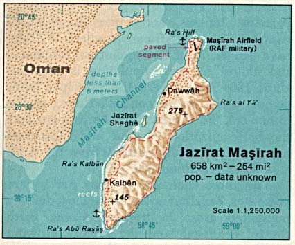
Masirah Island (Arabic: جَزِيْرَة مَصِيْرَة, romanized: Jazīrat Maṣīrah), also referred to as Mazeira Island, is an island off the east coast of mainland Oman in the Arabian Sea, and the largest island of the country. Administratively, it forms one of the five provinces (Wilayah, plural Wilayat) of the Ash Sharqiyah South Governorate, namely Wilāyat Maṣīrah (Arabic: وِلَايَة مَصِيْرَة); previously it was a province of the Ash Sharqiyah Region.
Masirah is 95 km (59 miles) long north–south, between 12 and 14 km (7.5 and 8.7 miles) wide, with an area of about 649 km2, and a population estimated at 12,000 in 12 villages mainly in the north of the island (9,292 as of the census of 2003, of which were 2,311 foreigners). It is divided from the mainland by the Masirah Channel. Most of the island's interior is deserted, with access to the island possible by ferry on National Ferries Company (NFC) or smaller privately owned ferries for cars and passengers. Salam Air also flies to Masirah weekly.
The principal village of Wilayat Masirah is Raʾs-Ḥilf (Arabic: رَأْس حِلْف) in the northern part of the island. It contains a Royal Air Force of Oman air base and a fish factory, as well as a few small towns. Previously, the BBC had a relay facility consisting of both HF and MF broadcasting transmitters stationed there. The main industries are fishing and traditional textile manufacturing. Formerly, traditional shipbuilding was important.
Located about 19 km (12 miles) off the east side of Barr al Hikman, the island is generally hilly, especially on its east side. The hills along the east side of the island are separated from the island coast by a narrow sandy plain; they run nearly its entire length. A steep plateau stands in the middle of the range on the northeast side of the island. Along the west side of the island, there are a few low hills separated from the east range by an extensive sandy plain marked by several hillocks:
The rugged terrain of the island and surrounding rough coastline has led to the appearance of many wrecked dhows on the beaches of the island, most of them well preserved by the salt water and intense heat. On 21 September 1835, the USS Peacock grounded on a coral reef.
The ocean bottom environment surrounding Masirah is hostile as the majority of the area is covered in either sand or hard rock. There is a swift current flowing through the area with a very sharp halocline visible on the surface of the ocean. The water depth nearby is around 10 m and is not conducive to side-scan sonar searches due to the shallow water and choppy surface conditions. Despite the poor quality ocean bottom, the area is very productive with marine fisheries, and any hard objects (barrels, engines) are immediately colonised by local fauna.
During summer there is normally a constant strong wind which is ideal for kite and windsurfers. Big waves are a result of the wind on the sea side and is so also attractive for wave surfers. Kite and windsurfers can pick spots around the island according to their skill and what conditions they prefer. On 5–6 June 2007, 7000 people on the island were forced to temporarily leave their homes due to the high storm waves produced by the powerful Cyclone Gonu, the strongest to hit the Persian Gulf region in 60 years.
The island is an important hatching ground for loggerhead sea turtles, similar in importance to the beaches at Ras al Hadd and nearby Ras al-Jinz as a hatching ground for green sea turtles. A critically endangered local population of humpback whales also migrate in the waters surrounding the island and Masirah gulf. The island has been designated an Important Bird Area (IBA) by BirdLife International because it supports many species of waders and seabirds, as well as Egyptian vultures.
Hub AI
Masirah Island AI simulator
(@Masirah Island_simulator)
Masirah Island
Masirah Island (Arabic: جَزِيْرَة مَصِيْرَة, romanized: Jazīrat Maṣīrah), also referred to as Mazeira Island, is an island off the east coast of mainland Oman in the Arabian Sea, and the largest island of the country. Administratively, it forms one of the five provinces (Wilayah, plural Wilayat) of the Ash Sharqiyah South Governorate, namely Wilāyat Maṣīrah (Arabic: وِلَايَة مَصِيْرَة); previously it was a province of the Ash Sharqiyah Region.
Masirah is 95 km (59 miles) long north–south, between 12 and 14 km (7.5 and 8.7 miles) wide, with an area of about 649 km2, and a population estimated at 12,000 in 12 villages mainly in the north of the island (9,292 as of the census of 2003, of which were 2,311 foreigners). It is divided from the mainland by the Masirah Channel. Most of the island's interior is deserted, with access to the island possible by ferry on National Ferries Company (NFC) or smaller privately owned ferries for cars and passengers. Salam Air also flies to Masirah weekly.
The principal village of Wilayat Masirah is Raʾs-Ḥilf (Arabic: رَأْس حِلْف) in the northern part of the island. It contains a Royal Air Force of Oman air base and a fish factory, as well as a few small towns. Previously, the BBC had a relay facility consisting of both HF and MF broadcasting transmitters stationed there. The main industries are fishing and traditional textile manufacturing. Formerly, traditional shipbuilding was important.
Located about 19 km (12 miles) off the east side of Barr al Hikman, the island is generally hilly, especially on its east side. The hills along the east side of the island are separated from the island coast by a narrow sandy plain; they run nearly its entire length. A steep plateau stands in the middle of the range on the northeast side of the island. Along the west side of the island, there are a few low hills separated from the east range by an extensive sandy plain marked by several hillocks:
The rugged terrain of the island and surrounding rough coastline has led to the appearance of many wrecked dhows on the beaches of the island, most of them well preserved by the salt water and intense heat. On 21 September 1835, the USS Peacock grounded on a coral reef.
The ocean bottom environment surrounding Masirah is hostile as the majority of the area is covered in either sand or hard rock. There is a swift current flowing through the area with a very sharp halocline visible on the surface of the ocean. The water depth nearby is around 10 m and is not conducive to side-scan sonar searches due to the shallow water and choppy surface conditions. Despite the poor quality ocean bottom, the area is very productive with marine fisheries, and any hard objects (barrels, engines) are immediately colonised by local fauna.
During summer there is normally a constant strong wind which is ideal for kite and windsurfers. Big waves are a result of the wind on the sea side and is so also attractive for wave surfers. Kite and windsurfers can pick spots around the island according to their skill and what conditions they prefer. On 5–6 June 2007, 7000 people on the island were forced to temporarily leave their homes due to the high storm waves produced by the powerful Cyclone Gonu, the strongest to hit the Persian Gulf region in 60 years.
The island is an important hatching ground for loggerhead sea turtles, similar in importance to the beaches at Ras al Hadd and nearby Ras al-Jinz as a hatching ground for green sea turtles. A critically endangered local population of humpback whales also migrate in the waters surrounding the island and Masirah gulf. The island has been designated an Important Bird Area (IBA) by BirdLife International because it supports many species of waders and seabirds, as well as Egyptian vultures.