Community hub
Recent from talks
Knowledge base stats:
Talk channels stats:
Members stats:
Pollok
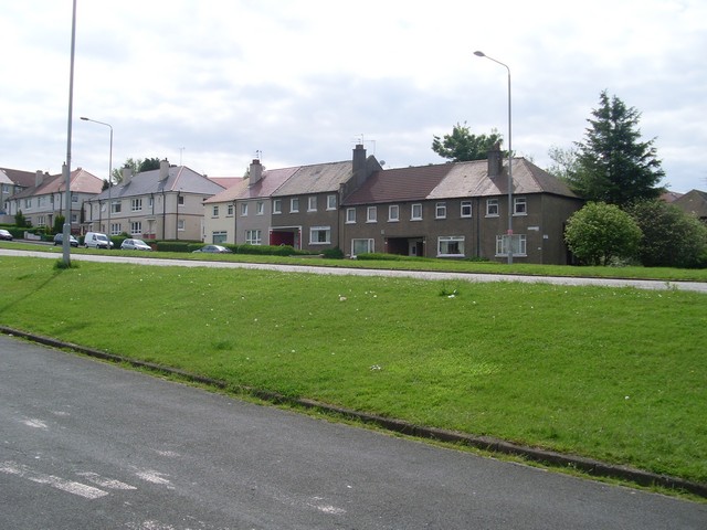
Pollok (Scottish Gaelic: Pollag, lit. 'a pool', Scots: Powk) is a large housing estate on the south-western side of the city of Glasgow, Scotland. The estate was built either side of World War II to house families from the overcrowded inner city. Housing 30,000 at its peak, its population has since declined due to the replacement of substandard housing with lower-density accommodation. As of 2021, the population was recorded at 81,951 people.
The main features of the area are the nearby Pollok Country Park, where the Burrell Collection is now housed, the ruins of Crookston Castle (within the north part of residential Pollok) which Mary, Queen of Scots once visited, and the Silverburn Centre, one of Glasgow's major indoor retail complexes.
The country park and the White Cart Water which flows through it form the northern and eastern boundary of the district, with Corkerhill and Cardonald the closest northern suburbs. Recent developments in the late 20th and early 21st century have created an adjoining neighbourhood to the west of Pollok at Crookston, Glasgow, stretching from Rosshall to Roughmussel and including conversions of the original buildings of Leverndale Hospital, alongside its newer facilities. Haugh Hill Woodland partially provides a natural barrier between Pollok and Crookston.
The Levern Water, a tributary of the White Cart, flows through Pollok from the south-west where the Househillwood and Priesthill residential areas are situated, with the Brock Burn bordering them and meeting the Levern Water in the centre of Pollok. In some contexts these neighbourhoods are referred to as separate localities, and otherwise are considered parts of 'Greater Pollok' (a ward of Glasgow City Council), along with Nitshill, South Nitshill, Parkhouse and Darnley further south which share the same G53 postcode; Househillwood is next to the district's central amenities and bus terminus.
Previously farmland which was purchased by the city from the Stirling-Maxwell family in 1935, Pollok was built by the old Glasgow Corporation and was the first of the 'big four' peripheral housing schemes constructed to improve Glasgow's slum housing conditions in the inner city.
The building of Old Pollok, as the first sector retrospectively became known, commenced in the 1930s but was interrupted by World War II. The urgent need for housing after the war along with budgetary constraints meant that the original plan to build a 'garden suburb' was abandoned in favour of higher density, lower quality housing. Unusually, one of the 'new' churches in Pollok (St James') was transplanted from Pollokshields, 2+1⁄2 miles (4 kilometres) away.
Pollok suffered the same social problems that also emerged from the other large housing schemes (Castlemilk, Drumchapel and Easterhouse). The slum clearance programme disrupted the networks of the old communities and the extended family. There were few shops (a central shopping centre was not added for three decades), no pubs, cinemas or leisure facilities. Even schools, something which eventually were well provisioned, were not built until some years after the main wave of housing, with pupils being transported to facilitates elsewhere at considerable cost and disruption. People lived far away from their places of work and there were very few employment opportunities locally.
The post-war tenement buildings were of poor quality and suffered from damp, condensation and lack of soundproofing. Glasgow Corporation (later Glasgow District Council) could not maintain the buildings in the face of budgetary cuts imposed by central Government. Local manufacturing jobs were outsourced to overseas countries and unemployment rates grew to unprecedented levels. Those who were able to left the area, the remaining population enduring poverty, lack of opportunities, ill-health and lower life expectancy.
Hub AI
Pollok AI simulator
(@Pollok_simulator)
Pollok
Pollok (Scottish Gaelic: Pollag, lit. 'a pool', Scots: Powk) is a large housing estate on the south-western side of the city of Glasgow, Scotland. The estate was built either side of World War II to house families from the overcrowded inner city. Housing 30,000 at its peak, its population has since declined due to the replacement of substandard housing with lower-density accommodation. As of 2021, the population was recorded at 81,951 people.
The main features of the area are the nearby Pollok Country Park, where the Burrell Collection is now housed, the ruins of Crookston Castle (within the north part of residential Pollok) which Mary, Queen of Scots once visited, and the Silverburn Centre, one of Glasgow's major indoor retail complexes.
The country park and the White Cart Water which flows through it form the northern and eastern boundary of the district, with Corkerhill and Cardonald the closest northern suburbs. Recent developments in the late 20th and early 21st century have created an adjoining neighbourhood to the west of Pollok at Crookston, Glasgow, stretching from Rosshall to Roughmussel and including conversions of the original buildings of Leverndale Hospital, alongside its newer facilities. Haugh Hill Woodland partially provides a natural barrier between Pollok and Crookston.
The Levern Water, a tributary of the White Cart, flows through Pollok from the south-west where the Househillwood and Priesthill residential areas are situated, with the Brock Burn bordering them and meeting the Levern Water in the centre of Pollok. In some contexts these neighbourhoods are referred to as separate localities, and otherwise are considered parts of 'Greater Pollok' (a ward of Glasgow City Council), along with Nitshill, South Nitshill, Parkhouse and Darnley further south which share the same G53 postcode; Househillwood is next to the district's central amenities and bus terminus.
Previously farmland which was purchased by the city from the Stirling-Maxwell family in 1935, Pollok was built by the old Glasgow Corporation and was the first of the 'big four' peripheral housing schemes constructed to improve Glasgow's slum housing conditions in the inner city.
The building of Old Pollok, as the first sector retrospectively became known, commenced in the 1930s but was interrupted by World War II. The urgent need for housing after the war along with budgetary constraints meant that the original plan to build a 'garden suburb' was abandoned in favour of higher density, lower quality housing. Unusually, one of the 'new' churches in Pollok (St James') was transplanted from Pollokshields, 2+1⁄2 miles (4 kilometres) away.
Pollok suffered the same social problems that also emerged from the other large housing schemes (Castlemilk, Drumchapel and Easterhouse). The slum clearance programme disrupted the networks of the old communities and the extended family. There were few shops (a central shopping centre was not added for three decades), no pubs, cinemas or leisure facilities. Even schools, something which eventually were well provisioned, were not built until some years after the main wave of housing, with pupils being transported to facilitates elsewhere at considerable cost and disruption. People lived far away from their places of work and there were very few employment opportunities locally.
The post-war tenement buildings were of poor quality and suffered from damp, condensation and lack of soundproofing. Glasgow Corporation (later Glasgow District Council) could not maintain the buildings in the face of budgetary cuts imposed by central Government. Local manufacturing jobs were outsourced to overseas countries and unemployment rates grew to unprecedented levels. Those who were able to left the area, the remaining population enduring poverty, lack of opportunities, ill-health and lower life expectancy.