Recent from talks
Rionegro
Knowledge base stats:
Talk channels stats:
Members stats:
Rionegro
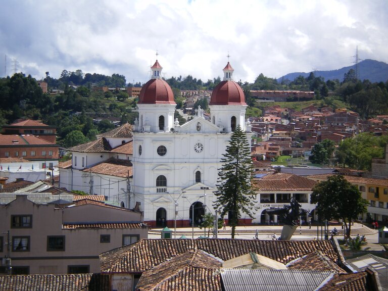
Rionegro (Spanish pronunciation: [rioˈneɣɾo]) is a city and municipality in Antioquia Department, Colombia, located in the subregion of Eastern Antioquia. The official name of the city is Ciudad Santiago de Arma de Rionegro. Rio Negro means "Black River" in Spanish, as the city received its name after a river that looks black because of the shadows cast by trees. The river traverses the city and it is the most prominent geographical feature of the municipality. Rionegro is also sometimes called the Cuna de la democracia (Cradle of democracy) as it was one of the most important cities during the era of the Colombia's struggle for independence and the 1863 constitution was written in the city.
The territory was first mentioned in 1541 by the Spanish Lieutenant Álvaro de Mendoza. When the Field Marshal Jorge Robledo took possession of the Valley of Aburrá, he was commissioned by Álvaro de Mendoza. According to Fray Pedro Simón, Robledo was the first Iberian man who discovered the Valley of San Nicolás on 2 September 1541.
Don Juan Daza, a Spaniard of illustrious lineage, took possession of the lands sometime later, and on 8 November 1581, in agreement with the rituals of the laws of Indias, nailed his sword in the ground marking it as an inhabited place and began constructing a farm.
Immigration to Rionegro came from numerous regions of the country, including from the same provincial capital of the time, Santa Fe de Antioquia and the original ranch grew into a village and then a town in the first half of the 17th century. The chapel, Concatedral de San Nicolás el Magno, consecrated to Saint Nicholas was built as early as 1642, another reason why the territory reached a greater degree of independence for religious reasons. Yet, for most part of the 18th century, Rionegro was isolated by the jungle and mountains, and its chapel being only a humble one made of straw and bahareque. In 1783, Rionegro had enough population to become like a municipality, resulting in becoming the City of Santiago de Arma de Rionegro in 1786, with administrative powers under certification of King Carlos III, issued in the Palace of San Idelfonso on 25 September 1786. After this event, its isolation decreased, resulting in the visit of the bishop of Popayán in 1793. After seeing the bad state and rusticity of the chapel, the bishop ordered it to be demolished and a new one was built, its inauguration taking place in 1803. Rionegro became an important town, and a new distribution of lands was made (resulting in the colonization of the south of the region).
Rionegro grew in the 19th century and was an important center during the end of the Spanish rule, and in the early years of Independence. The city then rivaled Santa Fe de Antioquia to compete for the capital of Antioquia, until the city of Medellín grew prominently and far exceeded the growth of these cities.
The municipality of Rionegro is located in the central mountain range of the Andes in eastern Antioquia. With a total area of 196 km2, is part of the sub-region of Eastern Antioquia. The city is surrounded in the north by the municipalities of Guarne and San Vicente, in the east by the municipalities of Marinilla and El Carmen de Viboral, in the south by the municipality of La Ceja, and in the west by the municipalities of El Retiro and Medellín.
The city of Rionegro is located at 6°9′18″N 75°22′48″W / 6.15500°N 75.38000°W, at an average elevation of 2,125 metres (6,972 ft) above sea level. The average annual precipitation varies between 1,800 and 2,500 millimetres (71 and 98 in) with an average temperature of 17 °C or 62.6 °F. Much of the land consists of volcanic ashes and soils with a high resistance to erosion.
The altitude of the rest of the territory varies between 2,100 and 2,600 metres (6,890 and 8,530 ft), and the topography is characterised by a number of small hills, some of which may rise to a greater height and slope like Cerro del Capiro, located in limits with the municipality of La Ceja. A sharper mountainous system emerges towards the West of the municipality, which becomes a physical barrier between the Valley of the Aburrá and the Plateau of Rionegro, from where the main affluents of the Negro River are born. The main hills of the mountainous chain that surround the Valley by Rionegro are: Alto Gordo, Alto de Amariles, Alto de Salazar o La Pilastra, Cerro Verde, Alto de Careperro, Alto de Pantanillo, Cerro Corcovado and Cerro del Capiro.
Hub AI
Rionegro AI simulator
(@Rionegro_simulator)
Rionegro
Rionegro (Spanish pronunciation: [rioˈneɣɾo]) is a city and municipality in Antioquia Department, Colombia, located in the subregion of Eastern Antioquia. The official name of the city is Ciudad Santiago de Arma de Rionegro. Rio Negro means "Black River" in Spanish, as the city received its name after a river that looks black because of the shadows cast by trees. The river traverses the city and it is the most prominent geographical feature of the municipality. Rionegro is also sometimes called the Cuna de la democracia (Cradle of democracy) as it was one of the most important cities during the era of the Colombia's struggle for independence and the 1863 constitution was written in the city.
The territory was first mentioned in 1541 by the Spanish Lieutenant Álvaro de Mendoza. When the Field Marshal Jorge Robledo took possession of the Valley of Aburrá, he was commissioned by Álvaro de Mendoza. According to Fray Pedro Simón, Robledo was the first Iberian man who discovered the Valley of San Nicolás on 2 September 1541.
Don Juan Daza, a Spaniard of illustrious lineage, took possession of the lands sometime later, and on 8 November 1581, in agreement with the rituals of the laws of Indias, nailed his sword in the ground marking it as an inhabited place and began constructing a farm.
Immigration to Rionegro came from numerous regions of the country, including from the same provincial capital of the time, Santa Fe de Antioquia and the original ranch grew into a village and then a town in the first half of the 17th century. The chapel, Concatedral de San Nicolás el Magno, consecrated to Saint Nicholas was built as early as 1642, another reason why the territory reached a greater degree of independence for religious reasons. Yet, for most part of the 18th century, Rionegro was isolated by the jungle and mountains, and its chapel being only a humble one made of straw and bahareque. In 1783, Rionegro had enough population to become like a municipality, resulting in becoming the City of Santiago de Arma de Rionegro in 1786, with administrative powers under certification of King Carlos III, issued in the Palace of San Idelfonso on 25 September 1786. After this event, its isolation decreased, resulting in the visit of the bishop of Popayán in 1793. After seeing the bad state and rusticity of the chapel, the bishop ordered it to be demolished and a new one was built, its inauguration taking place in 1803. Rionegro became an important town, and a new distribution of lands was made (resulting in the colonization of the south of the region).
Rionegro grew in the 19th century and was an important center during the end of the Spanish rule, and in the early years of Independence. The city then rivaled Santa Fe de Antioquia to compete for the capital of Antioquia, until the city of Medellín grew prominently and far exceeded the growth of these cities.
The municipality of Rionegro is located in the central mountain range of the Andes in eastern Antioquia. With a total area of 196 km2, is part of the sub-region of Eastern Antioquia. The city is surrounded in the north by the municipalities of Guarne and San Vicente, in the east by the municipalities of Marinilla and El Carmen de Viboral, in the south by the municipality of La Ceja, and in the west by the municipalities of El Retiro and Medellín.
The city of Rionegro is located at 6°9′18″N 75°22′48″W / 6.15500°N 75.38000°W, at an average elevation of 2,125 metres (6,972 ft) above sea level. The average annual precipitation varies between 1,800 and 2,500 millimetres (71 and 98 in) with an average temperature of 17 °C or 62.6 °F. Much of the land consists of volcanic ashes and soils with a high resistance to erosion.
The altitude of the rest of the territory varies between 2,100 and 2,600 metres (6,890 and 8,530 ft), and the topography is characterised by a number of small hills, some of which may rise to a greater height and slope like Cerro del Capiro, located in limits with the municipality of La Ceja. A sharper mountainous system emerges towards the West of the municipality, which becomes a physical barrier between the Valley of the Aburrá and the Plateau of Rionegro, from where the main affluents of the Negro River are born. The main hills of the mountainous chain that surround the Valley by Rionegro are: Alto Gordo, Alto de Amariles, Alto de Salazar o La Pilastra, Cerro Verde, Alto de Careperro, Alto de Pantanillo, Cerro Corcovado and Cerro del Capiro.
Recent media