Hubbry Logo
Dry lakeDry lakeMain
Open search
Dry lake
Community hub
Dry lake
logo
8 pages, 0 posts
0 subscribers
Be the first to start a discussion here.
Dry lake
Dry lake
from Wikipedia
The Salar de Uyuni, in Bolivia, the world's largest salt flat

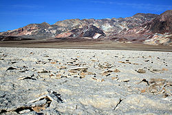
A dry lake bed, also known as a playa (/ˈpl-ə/), is a basin or depression that formerly contained a standing surface water body, which disappears when evaporation processes exceed recharge. If the floor of a dry lake is covered by deposits of alkaline compounds, it is known as an alkali flat. If covered with salt, it is known as a salt flat.

Terminology

[edit]

If its basin is primarily salt, then a dry lake bed is called a salt pan, pan, or salt flat (the latter being a remnant of a salt lake). Hardpan is the dry terminus of an internally drained basin in a dry climate, a designation typically used in the Great Basin of the western United States.[citation needed]

The Chott el Djerid in Tunisia

Another term for dry lake bed is playa. The Spanish word playa (pronounced [ˈplaʝa]) literally means "beach". Dry lakes are known by this name in some parts of Mexico and the western United States. This term is used e.g. on the Llano Estacado and other parts of the Southern High Plains and is commonly used to address paleolake sediments in the Sahara like Lake Ptolemy.

Namak Lake, Iran

In South America, the usual term for a dry lake bed is salar or salina, Spanish for salt pan.

Pan is the term used in most of South Africa. These may include the small round highveld pans, typical of the Chrissiesmeer area, to the extensive pans of the Northern Cape province.

Terms used in Australia include salt pans (where evaporite minerals are present) and clay pans.[1]

In Arabic, a salt flat is called a sabkha (also spelled sabkhah, subkha or sebkha) or shott (chott). In Central Asia, a similar "cracked mud" salt flat is known as a takyr. In Iran salt flats are called kavir.

Formation

[edit]
Sailing stone in Racetrack Playa

A dry lake is formed when water from rain or other sources, like intersection with a water table, flows into a dry depression in the landscape, creating a pond or lake. If the total annual evaporation rate exceeds the total annual inflow, the depression will eventually become dry again, forming a dry lake. Salts originally dissolved in the water precipitate out and are left behind, gradually building up over time. A dry lake appears as a flat bed of clay, generally encrusted with precipitated salts. These evaporite minerals are a concentration of weathering products such as sodium carbonate, borax, and other salts. In deserts, a dry lake may be found in an area ringed by bajadas.

Dry lakes are typically formed in semi-arid to arid regions of the world. The largest concentration of dry lakes (nearly 22,000) is in the southern High Plains of Texas and eastern New Mexico.[citation needed] Most dry lakes are small. However, Salar de Uyuni in Bolivia, near Potosí, the largest salt flat in the world, comprises 4,085 square miles (10,582 square km).[2]

Many dry lakes contain shallow water during the rainy season, especially during wet years. If the layer of water is thin and is moved around the dry lake bed by wind, an exceedingly hard and smooth surface may develop. Thicker layers of water may result in a "cracked-mud" surface and teepee structure desiccation features. If there is very little water, dunes can form.

The Racetrack Playa, located in Death Valley, California, features a geological phenomenon known as "sailing stones" that leave "racetrack" imprints as they slowly move across the surface without human or animal intervention. These rocks have been recently filmed in motion by the Scripps Institution of Oceanography at the University of California, San Diego and are due to a perfect coincidence of events. First, the playa has to fill with water, which must be deep enough to form floating ice during winter, but still shallow enough that the rocks are exposed. When the temperature drops at night, this pond freezes into thin sheets of "windowpane" ice, which then must be thick enough to maintain strength, but thin enough to move freely. Finally, when the sun comes out, the ice melts and cracks into floating panels; these are blown across the playa by light winds, propelling the rocks in front of them.[3] The stones only move once every two or three years and most tracks last for three or four years.[4]

Ecology

[edit]

While a dry lake bed is itself typically devoid of vegetation, they are commonly ringed by shadscale, saltbrush and other salt-tolerant plants that provide critical winter fodder for livestock and other herbivores.

Playa in southwest Idaho, home to a number of rare species that occur nowhere else including Lepidium davisii (Davis' peppergrass) and Branchinecta raptor - a recently discovered giant fairy shrimp.

In southwest Idaho and parts of Nevada and Utah there are a number of rare species that occur nowhere else but in the inhospitable environment of seasonally flooded playas. A new species of giant fairy shrimp was found in 2006. Although a large predatory species, it evaded detection because of the murkiness of the playa's water caused by winds and a fine clay load. This shrimp species is able to regenerate using tiny undetectable cysts that can remain in a dry lake bed for years until conditions are optimum for hatching.[5]

Lepidium davisii is another rare species, a perennial plant whose habitat is restricted to playas in southern Idaho and northern Nevada.[6]

Far from major rivers or lakes, playas are often the only water available to wildlife in the desert. Antelope and other wildlife gather there after rainstorms to drink.

Threats to dry lakes include pollution from concentrated animal feeding operations such as cattle feedlots and dairies. Results are erosion; fertilizer, pesticide and sediment runoff from farms; and overgrazing.[6] A non-native shrub that has been used for rangeland restoration in the west, Kochia prostrata, also poses a significant threat to playas and their associated rare species, as it capable of crowding out native vegetation and draining a playa's standing water because of its root growth.

Human use

[edit]
The Mosaic Company chemical plant processes brines from Searles Dry Lake to make such products as trona

The extremely flat, smooth, and hard surfaces of dry lake beds make them ideal for fast motor vehicles and motorcycles. Large-sized dry lakes are excellent spots for pursuing land speed records, as the smoothness of the surface allows low-clearance vehicles to travel very fast without any risk of disruption by surface irregularities, and the path traveled has no obstacles to avoid. The dry lake beds at Bonneville Salt Flats in Utah and Black Rock Desert in Nevada have both been used for setting land speed records. Lake Eyre and Lake Gairdner in South Australia have also been used for various land speed record attempts. Dry lake beds that rarely fill with water are sometimes used as locations for air bases for similar reasons. Examples include Groom Lake at Area 51 in Nevada and Edwards Air Force Base (known initially as Muroc Dry Lake) in California.

Satellite view of a lithium brine extraction field in the Salar de Uyuni, Bolivia

Brines from the subsurface of dry lakes are often exploited for valuable minerals in solution. See, for example, Searles Dry Lake and Lithium resources.

Under United States law, a "playa lake" may be considered isolated wetlands and may be eligible to enroll in the new wetlands component of the Conservation Reserve Program, enacted in the 2002 farm bill (P.L. 107–171, Sec. 2101).[7]

The Burning Man yearly event takes place in a playa in the Black Rock Desert in western Nevada every year.

Fangfang Yao et al (2023),[8] at the University of Virginia reported that more than half of the world's large lakes are drying up. They assessed almost 2,000 large lakes using satellite measurements combined with climate and hydrological models. They found that unsustainable human use, changes in rainfall and run-off, sedimentation, and rising temperatures have driven lake levels down globally, with 53% of lakes showing a decline from 1992 to 2020.[9]

[edit]

See also

[edit]

References

[edit]

Bibliography

[edit]
Revisions and contributorsEdit on WikipediaRead on Wikipedia
from Grokipedia
A dry lake, also known as a playa, is a flat, vegetation-free depression at the bottom of an undrained basin in arid or semi-arid regions, where a temporary lake forms during periods of heavy rainfall or but dries out due to high rates exceeding inflow. These features are typically underlain by layers of fine-grained clay, , , and soluble salts, resulting in a cracked, often salt-encrusted surface when dry. Dry lakes play a critical role in local by recharging aquifers, such as the in the U.S. High Plains, and serve as ephemeral wetlands supporting . Dry lakes form in endorheic (closed) basins, where topographic barriers like fault lines, lava flows, or alluvial fans prevent water from draining to the ocean, causing sediments to accumulate through wave action and thin water sheets during wet phases. Geologically, they are common indicators of past pluvial (wet) climates, formed during the (approximately 21,000 years ago) when larger lakes flooded these basins, with many in the drying up around 8,000 years ago. Globally, they occur in environments, including the largest salt flat, in , which spans over 4,000 square miles and contains vast reserves. Ecologically, dry lakes are vital habitats for migratory birds, waterfowl, amphibians, and during their brief wet periods, providing breeding and grounds in otherwise barren landscapes; for instance, the High Plains host about 19,300 playas that support up to 300,000 wintering geese and recharge up to 95% of local water. However, they can also contribute to environmental challenges, such as generating mineral dust during windstorms that impacts air quality and human health. Notable U.S. examples include in California's , covering 60 square miles, and in , used for land speed records due to their flat, hard-packed surfaces.

Terminology and Definition

Core Definition

A dry lake, also known as a playa, is a flat, dry basin or depression typically located at the lowest point of an undrained or , where surface water periodically accumulates but evaporates rapidly, leaving behind a barren, vegetation-free expanse for most of the year. This occurs in arid and semi-arid environments where rates greatly exceed and any inflow from surrounding drainage areas, resulting in the basin remaining predominantly dry. The surface often consists of fine sediments, salts, or evaporites deposited from the temporary water bodies. Dry lakes are the dry beds of ephemeral lakes, which fill temporarily during wet periods but lack outlets, leading to complete and minimal biotic cover when dry. They differ from permanent lakes, which sustain water levels year-round through consistent inflows like rivers or that balance and outflow. Unlike salt marshes, which are coastal intertidal zones dominated by salt-tolerant and influenced by , dry lakes form in inland, closed basins without tidal or persistent vegetative cover. These features are commonly situated in endorheic basins, lacking outlets to oceans or major rivers, and vary widely in scale—from small playas spanning mere hectares to expansive salt flats covering thousands of square kilometers, such as California's Owens Dry Lake, which once exceeded 280 square kilometers when inundated. The recognition of dry lakes as distinct geomorphic features emerged in the 19th century through systematic geological surveys of the American Southwest, where explorers documented these arid landforms during expeditions mapping the region's and terrain. Early accounts from surveys like those conducted by the U.S. Geological Survey in the 1870s highlighted their role in understanding desert basin dynamics.

Synonyms and Regional Variations

Dry lakes are referred to by a variety of synonyms that reflect their appearance and environmental context, with "playa" being a prominent term originating from the Spanish word for "" or "shore," commonly used in North American to describe flat, basin-like depressions that periodically hold . Other widespread English-language synonyms include "salt pan," which emphasizes saline crusts formed by , and "alkali flat," highlighting the presence of alkaline minerals in the sediment. The term "," borrowed from سَبْخَة (sabkha), meaning a salt-encrusted flat, is frequently applied to coastal or near-coastal variants in the , often denoting areas influenced by tidal or evaporation. Regional terminology further diversifies the , adapting to local languages and landscapes. In Andean , "salar"—derived from Spanish "sal" (salt) combined with the infinitive suffix "-ar," indicating a salt-producing flat—is the standard term for large, hypersaline dry lake beds, such as those in and . North African deserts employ "chott" or "shott," a French adaptation of the شَطّ (shaṭṭ), originally meaning "river bank" or "coast," to describe shallow, saline depressions that dry seasonally. In Iranian deserts, "kavir," borrowed from Persian کَوِیر (kavīr) signifying a or barren plain, refers to vast, cracked mudflats with deposits. These terms often trace their etymological roots to indigenous or colonial languages that capture observations of the local environment, such as the flat, expansive nature resembling shores or banks where water once gathered before evaporating. For instance, the Spanish "playa" evolved from Latin "plaga," denoting a broad region or shore, reflecting early European explorers' impressions of these features in arid terrains. Similarly, Arabic-derived terms like and chott stem from Semitic roots associated with flat, low-lying areas prone to salinization, underscoring centuries of regional environmental knowledge. Persian "kavir" similarly evokes desolate, salt-impregnated expanses observed in Central Asian arid zones. Terminology also varies based on levels, distinguishing between non-saline or fresh- dry beds—often called "clay pans" or "hardpans" for their compacted, mud-dominated surfaces—and hypersaline pans, which are termed "salt flats" or "salars" due to their crystalline layers. This distinction highlights how linguistic choices encode differences in chemistry and composition, with fresher variants lacking the mineral crusts characteristic of their saline counterparts.

Formation and Geology

Geological Processes

Dry lakes, also known as playas, primarily form through tectonic processes that create closed basins incapable of external drainage. Tectonic subsidence, often associated with extensional faulting in rift zones or basin-and-range provinces, generates depressions where sediment accumulates over time, trapping water and sediments from surrounding highlands. For instance, in the Basin and Range Province of the western United States, normal faulting has produced asymmetric valleys with subsiding floors, such as those in Death Valley, allowing ancient water bodies to fill and deposit layers of clay, silt, and sand. Volcanic activity can also contribute by producing lava flows that dam preexisting drainages or form caldera-like depressions, further isolating basins and promoting sediment buildup from episodic flooding. These closed basins operate as endorheic systems, characterized by internal drainage where and runoff collect without outflow , leading to progressive concentration of dissolved salts. In such basins, water inflows from streams or exceed only temporarily, resulting in solute accumulation as minerals precipitate upon . This dynamic fosters the development of evaporites, including and , which layer onto the accumulating sediments and alter basin by increasing and reducing permeability. The evaporative drying process follows as intensifies, initiating lake shrinkage through sustained water loss that outpaces replenishment. As levels drop, finer sediments settle in the basin center via or shallow wave action, while salts crystallize along shrinking shorelines, eventually forming a desiccated surface with polygonal cracks and efflorescent crusts. This sequence culminates in a flat, barren playa floor, where repeated wetting and drying cycles further compact sediments and enhance crust durability. Climatic shifts can accelerate this drying, but the underlying geological isolation dictates the basin's vulnerability. Many dry lakes trace their origins to the Pleistocene epoch, when lakes filled endorheic basins during wetter glacial periods, only to desiccate amid post-glacial warming around 8,000 to 13,000 years ago. Examples include ancient Lake Mojave in the , which left behind sediment stacks and shoreline features as it evaporated following the . These timelines highlight how tectonic stability preserved basins while climatic transitions drove the final drying.

Climatic and Hydrological Factors

Dry lakes, also known as playas or closed-basin lakes, form and persist in arid and semiarid environments where annual precipitation is typically less than 250 mm, allowing evaporation to dominate the water balance. In these regions, potential evaporation rates significantly exceed precipitation, often by a factor of 5 to 25 times, leading to net water loss and the eventual desiccation of any standing water. This climatic imbalance is essential for maintaining the dry surface characteristic of these features, as closed basins lack outlets for water to escape, concentrating the effects of aridity. The hydrological cycle of dry lakes involves episodic inputs of followed by rapid loss, driven by the irregularity of arid rainfall patterns. Rare but intense storms or seasonal floods fill the basin, creating temporary shallow lakes that may last from days to months, depending on the volume of inflow and basin size. Once filled, high temperatures and low humidity accelerate evaporation, often drying the lake within weeks; for example, in the , playas like can hold up to 3 meters of briefly before desiccating into cracked, salt-encrusted flats. This intermittent wetting and drying cycle shapes the lake bed's morphology without sustained hydrologic outflow. Global atmospheric circulation patterns play a key role in creating the arid conditions conducive to dry lake formation, particularly through subtropical high-pressure systems and rain shadows. Subtropical highs, centered around 30° , promote descending air that inhibits cloud formation and precipitation, fostering vast desert regions where closed basins dominate. Rain shadows exacerbate this aridity on the leeward sides of mountain ranges, such as the Sierra Nevada in , where moist Pacific air is blocked, resulting in basins like those in the that host numerous dry lakes. Variability in dry lake characteristics arises from geographic position, with continental interiors experiencing more extreme aridity compared to coastal settings. Inland dry lakes, such as those in the Australian outback or the U.S. , rely solely on sporadic rainfall and runoff, with minimal additional moisture sources, leading to prolonged dry periods. In contrast, coastal dry lakes or sabkhas, like those along the Arabian Gulf or in the Namib Desert, benefit from and marine aerosols that provide supplementary , occasionally mitigating rates despite low rainfall. This fog-driven moisture sustains subtle hydrologic differences, allowing for thinner salt crusts or intermittent seepage in coastal sabkhas.

Physical Characteristics

Surface Morphology

Dry lakes, also known as playas, typically feature expansive, flat beds that result from the leveling action of standing water during periodic flooding, creating surfaces with minimal topographic relief, often on the order of centimeters per kilometer. These beds are composed of fine-grained sediments such as clay and , which upon form distinctive polygonal crack patterns due to shrinkage from evaporative drying. For instance, in the , giant polygonal fissures can extend several meters deep, reflecting contraction of underlying sediments. The boundaries of dry lake surfaces often include surrounding mudflats, alluvial fans, or sand dunes that demarcate the transition from the central basin to adjacent . Central zones tend to be the flattest and most desiccated, while peripheral areas may exhibit sloped annuli or gentler gradients where sediment deposition varies. In the Sabzevar Playa of northeastern , for example, the surface divides into a marginal clay pan, a central puffy ground, and a western salt-encrusted zone, illustrating zonal differentiation influenced by and . Surface conditions fluctuate with ; after , the beds become muddy and may support sparse temporarily before hardening into durable crusts during arid periods. These crusts, often porous and irregular, form protective layers that stabilize the surface until subsequent wetting dissolves them. Sediment layers in dry lakes generally accumulate to depths of 1 to 10 meters, with basin sizes ranging from about 1 km² for small playas to over 10,000 km² for large ones, such as the in .

Mineral Composition

Dry lakes, also known as playas, accumulate minerals through the concentration of dissolved salts in episodic floodwaters that evaporate under arid conditions. The primary minerals include halides such as (NaCl), sulfates like (CaSO₄·2H₂O), and carbonates including (Na₂CO₃·NaHCO₃·2H₂O), which form due to the hypersaline nature of the brines, often reaching salt contents of 10-30% by weight in the sediments. typically dominates the composition in many deposits, comprising the bulk of the soluble fraction, while and appear in significant quantities in alkaline settings. Mineral zonation is common, with inner basin cores exhibiting higher salinity and more soluble evaporites like halite, contrasting with outer margins that preserve fresher sediments rich in carbonates such as calcite and dolomite. This pattern arises from differential evaporation rates and brine flow, concentrating sodium and chloride inward while calcium and magnesium precipitate peripherally. Some dry lake basins show enrichment in trace elements, including boron as borates (e.g., borax, Na₂B₄O₇·10H₂O) and lithium, particularly in closed hydrological systems where repeated evaporation cycles amplify their concentrations from inflowing groundwater or volcanic sources. These minerals form layered deposits through sequential precipitation as brine salinity increases during evaporation: less soluble compounds like gypsum deposit first, followed by halite and then more exotic phases like trona in highly concentrated solutions. This process creates varved sequences or surface crusts, with individual layers ranging from millimeters to centimeters thick and cumulative deposits reaching up to 1 meter or more in persistent arid environments. The of dry lakes is characterized by alkaline conditions, with pH typically ranging from 8 to 10, favoring the of minerals over more acidic counterparts. Analytical methods such as X-ray diffraction (XRD) are routinely employed to identify and quantify these evaporites, providing diffraction patterns that distinguish crystal structures of , , and with high precision.

Ecology and Biodiversity

Adapted Flora and Fauna

Dry lakes, characterized by their intermittent flooding and extreme salinity, support a specialized array of halophytic plants that have evolved mechanisms to tolerate high salt concentrations and aridity. Saltbush species in the genus Atriplex, such as Atriplex lentiformis, dominate the margins of dry lake beds, where their succulent leaves store water and reduce transpiration losses, enabling survival in saline, low-moisture soils. Pickleweed (Salicornia spp. and Allenrolfea occidentalis) forms dense mats on exposed lake beds, featuring jointed, fleshy stems that accumulate salts in vacuoles while maintaining photosynthesis during brief wet periods. Alkali grass (Puccinellia spp., including Puccinellia distans) thrives in the alkaline fringes, with adaptations like salt-excreting glands on leaves that prevent ion toxicity and allow growth in soils with electrical conductivities exceeding 20 dS/m. Invertebrates and microorganisms exhibit remarkable resilience to desiccation and hypersalinity in dry lake environments. (Artemia salina) produce dormant cysts that withstand complete drying and extreme salinities up to 300 g/L, hatching rapidly when water returns to the playa. Fairy shrimp (Branchinecta spp.) employ similar cyst-based dormancy, with eggs surviving burial in salt crusts for years until triggered by rainfall, allowing populations to recolonize ephemeral pools. bacteria, such as halophilic in the genera Haloarchaea, colonize the salt crusts, using osmoprotectants like to maintain cellular integrity amid desiccation and UV exposure. Vertebrate species are less common but include rarities adapted to the transient conditions of dry lakes. Burrowing owls (Athene cunicularia) nest along the vegetated edges of dry lakes, excavating burrows in friable soils for protection from predators and heat, while foraging on that emerge during wet phases. Life cycle strategies in dry lake biota emphasize and opportunistic to exploit unpredictable . Many , including halophytes and , rely on or egg banks in the , where propagules enter physiological to endure years of until cues like moisture break quiescence. During inundation, rapid occurs, as seen in algal blooms and fairy shrimp that complete generations in 2-week cycles, maximizing before resumes.

Ecological Roles and Threats

Dry lakes, also known as playas, play significant roles in arid and semi-arid ecosystems by facilitating during episodic wet periods, when infiltrates through clay-lined basins into underlying aquifers such as the Ogallala. This process is particularly vital in regions like the Southern High Plains, where unaltered playas can recharge aquifers at rates exceeding 3 inches per year, supporting long-term water storage and regional . Additionally, dry lakes serve as corridors for migratory birds, providing essential staging and feeding grounds along key flyways in ; for instance, saline playas in the support millions of waterfowl and shorebirds, including over 99% of the continent's Eared Grebes during migration. Sediments in these closed-basin systems also contribute to , with extant closed-basin lakes globally storing approximately 80.56 petagrams of organic carbon, acting as long-term sinks that link surface and geological carbon cycles. Natural threats to dry lakes primarily arise from wind erosion, which generates dust storms that degrade regional air quality by releasing fine particulate matter into the atmosphere. In drying salt lakes, such as exposed playas in the Great Basin, these events transport toxic dust laden with salts, heavy metals, and pathogens, exacerbating respiratory health risks and reducing visibility over vast distances. Anthropogenic pressures compound these issues, with groundwater overpumping leading to permanent drying of playas; for example, excessive extraction from the Ogallala Aquifer has caused numerous playa lakes along New Mexico's eastern border to desiccate entirely, disrupting recharge and habitat functions. Invasive species like tamarisk (Tamarix spp.) further alter local hydrology by accessing deep groundwater through extensive root systems and consuming high volumes of water, which lowers water tables and crowds out native vegetation in riparian zones adjacent to playas. Climate change amplifies these threats through increased aridity, with projections indicating reduced and surface water availability in southwestern U.S. aquifers, including those sustaining playa ecosystems. In arid regions, models forecast heightened evaporative demand and drier conditions, potentially shrinking lake and areas by up to 50% in vulnerable basins by 2100 under high-emission scenarios, thereby diminishing playa inundation frequency and ecological connectivity. These shifts, driven by anthropogenic warming, threaten the overall resilience of dry lake ecosystems by intensifying cycles and altering patterns.

Human Interactions

Uses and Exploitation

Dry lakes provide expansive, flat surfaces that have been utilized for transportation purposes, particularly as improvised runways for due to their smooth, hard-packed terrain. During , in served as a key training site for pilots flying P-38 Lightning fighters, B-24 Liberator bombers, and B-25 Mitchell bombers, with facilities established along its shores to support military aviation operations. In motorsports, dry lakes like the in have become iconic venues for land speed record attempts, leveraging their vast, level expanses for high-velocity runs. Events at Bonneville have facilitated numerous records across vehicle classes, with ongoing competitions in the 2020s setting new benchmarks, such as motorcycles reaching over 236 km/h in 2025. Resource extraction from dry lakes focuses on valuable minerals concentrated through evaporation processes, with operations targeting soda ash, borax, and emerging lithium deposits. At in , mining has produced borax since 1873 via surface extraction and brine processing, alongside soda ash derived from carbonated lake brines. Similarly, borax and soda ash are recovered from through historical and ongoing mineral harvesting techniques. For lithium, the in hosts the world's largest known reserves, exceeding 21 million tons, with pilot extraction methods like direct lithium extraction from brines poised to contribute significantly to global supply as production scales in the mid-2020s. Cultural events also capitalize on the open, transient nature of dry lake surfaces for temporary gatherings. The annual festival, held on the playa in , transforms the flat, alkaline lakebed into a site for art installations, performances, and community activities, drawing tens of thousands of participants each year since relocating there in 1990.

Hazards and Conservation Efforts

Dry lake beds pose several physical hazards to humans venturing onto their surfaces. After rainfall, the otherwise parched playa can transform into a sticky, mudflat-like expanse where vehicles and pedestrians may become trapped in quicksand-like conditions, as observed in drought-affected reservoirs where exposed sediments retain moisture unevenly. Extreme heat on the exposed lake bed surfaces exacerbates these risks, with ground temperatures often exceeding 66°C (150°F) during summer months, leading to heat stress and burns for those without proper protection. Additionally, the fine particulate matter from wind-eroded sediments creates significant dust inhalation risks; for instance, at Owens (Dry) Lake, these particles, laden with alkaline compounds and mining residues, can cause respiratory irritation, bloody noses, and exacerbated conditions like asthma in nearby communities. Similar dust from the Great Salt Lake playa has been shown to trigger pro-inflammatory responses in lung cells via oxidative stress and receptor activation. Conservation efforts for dry lakes emphasize their status as ephemeral wetlands, with several sites protected under the on Wetlands to safeguard and hydrological functions during wet periods. For example, Owens Dry Lake has undergone restoration through targeted water diversions from the , creating shallow flooding across 48.6 square miles to mitigate dust storms and revive habitats, as part of the largest air quality mitigation program in the United States. These interventions, initiated following legal mandates in the 1990s, have successfully reduced particulate matter emissions by stabilizing the playa surface. Modern conservation strategies address emerging threats from resource extraction, including post-2023 regulatory frameworks for near dry lake formations to curb depletion. The 2023 for the Thacker Pass Lithium Mine Project, approved by the , incorporates groundwater monitoring and mitigation measures to limit drawdown in adjacent basins, responding to concerns over long-term hydrological impacts. on exposed beds is tracked using satellite remote sensing; at Owens Dry Lake, Landsat imagery analyzes surface wetting and stability to optimize dust control, enabling timely adjustments to flooding regimes. Indigenous communities play a vital role in dry lake conservation through collaborative management, particularly for cultural sites. In the Owens Valley, the Big Pine Paiute Tribe partners with state agencies to integrate traditional ecological knowledge into restoration planning, helping to protect sacred landscapes affected by historical water diversions. Local tribes, including the Owens Valley Paiute, have nominated and had portions of Owens Lake listed on the National Register of Historic Places in 2025, emphasizing its enduring cultural significance and advocating for co-stewardship to preserve archaeological and spiritual resources.

Global Examples and Significance

Prominent Dry Lakes

in stands as the world's largest dry lake, spanning over 10,000 square kilometers in the high plateau at an elevation of 3,653 meters. This vast salt flat formed as a remnant of ancient Pleistocene lakes, such as Lago Minchin and Lago Tauca, with significant drying occurring around 40,000 years ago during lake level fluctuations between 26,000 and 12,000 years before present. During the rainy season, a shallow layer of water accumulates on the salt crust, creating a striking mirror-like reflection of the sky that can extend across much of the flat's surface. The in northwestern , , historically covered approximately 46 square miles (119 km²), though the intact has shrunk to about 35 square miles (91 km²) as of 2025 due to environmental changes and human impacts, forming a remnant of the ancient Lake Bonneville that once occupied over one-third of the state between 32,000 and 10,000 years ago. This endorheic basin's , up to 5 feet thick in places, provides a uniquely flat and hard surface that has hosted land speed record attempts since , when Teddy Tetzlaff unofficially reached 141.73 miles per hour in a . Subsequent events, including official world records set by figures like Sir in at 301.13 miles per hour, have solidified its role as a premier site for high-speed vehicle testing. Efforts to mitigate this decline include the Bureau of Land Management's Salt Laydown Project, which redistributes to rebuild the . Etosha Pan in northern encompasses about 4,730 square kilometers within , representing one of Africa's largest salt pans and a key feature of the Cuvelai-Etosha Basin. Typically dry, the pan intermittently fills with water during wet seasons from seasonal rainfall and upstream rivers, transforming the saline expanse into a temporary that attracts large concentrations of , including migratory birds like and pelicans, as well as herbivores drawn to the surrounding greening grasslands. This periodic inundation supports diverse game species year-round through adjacent perennial springs but peaks in ecological activity during these moist phases. Lake Eyre, also known as Kati Thanda, in is the largest dry lake in , with a surface area of 9,700 square kilometers, situated 15 meters below sea level in the vast . As an endorheic terminal lake, it remains mostly dry but receives smaller floodwaters every few years from distant rainfall in the basin's river systems, such as the and Diamantina River, leading to partial fillings that briefly expand its watery extent and stimulate brief bursts of aquatic life. These infrequent inundations highlight the lake's dependence on episodic monsoon-driven flows across the arid interior.

Cultural and Economic Importance

Dry lakes, also known as playas, hold profound cultural significance for many , particularly in arid regions of the American Southwest, where they are viewed as remnants of ancient wetlands that sustained life during wetter climatic periods. Tribal representatives from various Native American groups have shared extensive of these features, describing them as places tied to ancestral histories and ecological memory, evoking times when large lakes and marshes supported diverse ecosystems and human communities. For the Tribe, water sources in dry landscapes, including seasonal playas, are considered sacred, guiding migrations and symbolizing life-giving forces essential to their spiritual and cultural practices. These landforms also facilitated ancient and historical trade networks, serving as flat, hard-packed surfaces ideal for travel across otherwise rugged terrain. In the region, Native American trade routes traversed dry lake beds to exchange goods such as shells, salt, and , with sites like those near Lago Saco in acting as key trading villages. Later, in the 19th century, the mail route crossed numerous dry lake beds in , including playas between Sand Springs and Simpson Pass, enabling rapid transit over vast expanses despite the challenging, waterless conditions. Economically, dry lakes are increasingly vital for lithium extraction from brine deposits, particularly in salt flats or salars, which supply a critical for batteries and storage. In the United States, potential lithium recovery from such sources could require investments of $10 to $12 billion to meet rising demand, supporting a projected global market exceeding $70 billion by 2030. This emerging sector underscores the economic transformation of arid regions, with salars like Bolivia's representing vast untapped reserves essential for the energy transition. Tourism draws visitors to unique dry lake phenomena, such as the of in Death Valley , where rocks up to 700 pounds leave long trails across the flat surface, captivating scientists and adventurers alike. A 2014 study revealed that these movements occur when thin ice sheets form on shallow water pools during winter nights, then break into panels pushed by light winds (4–5 m/s) on sunny days, propelling rocks at speeds of 2–5 m/min and creating visible tracks as water recedes. This remote site, accessible only by rough dirt roads, attracts thousands annually, boosting local economies through guided tours and park fees while highlighting the geological wonders of dry lakes. Historically, dry lakes fueled mining booms that shaped regional development, notably the borax industry in California's during the late 19th and early 20th centuries. Discoveries in the at sites like Furnace Creek led to operations such as the Harmony Borax Works, where refined was hauled by famous 20-mule teams across 165 miles of desert, sparking economic growth and temporary boomtowns. By the early 1900s, similar deposits around in the sustained further booms, employing hundreds in extracting and related minerals from the evaporite-rich basins, which became synonymous with industrial ingenuity in harsh environments.

References

Add your contribution
Related Hubs
User Avatar
No comments yet.