
Community hub
Recent from talks
Contribute something
Nothing was collected or created yet.
Scheldt
View on WikipediaThis article needs additional citations for verification. (August 2018) |
| Scheldt | |
|---|---|
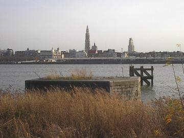
 The Scheldt in Antwerp | |
 Course of the Scheldt | |
   | |
 | |
| Native name | |
| Location | |
| Countries |
|
| Physical characteristics | |
| Source | |
| • location | France |
| • elevation | 97 m (318 ft) |
| Mouth | |
• location | North Sea |
• coordinates | 51°25′51″N 3°31′44″E / 51.43083°N 3.52889°E |
| Length | 360 km (220 mi) |
| Basin size | 21,863 km2 (8,441 sq mi) |
| Discharge | |
| • average | 104 m3/s (3,700 cu ft/s) |
| Official name | Schorren van de Beneden Schelde |
| Designated | 4 March 1986 |
| Reference no. | 327[1] |
| Official name | Westerschelde & Saeftinghe |
| Designated | 9 April 1995 |
| Reference no. | 748[2] |
| Official name | Vallées de la Scarpe et de l'Escaut |
| Designated | 2 February 2020 |
| Reference no. | 2405[3] |
The Scheldt (/ʃɛlt, skɛlt/ SHELT, SKELT; French: Escaut [ɛsko] ⓘ; Dutch: Schelde [ˈsxɛldə] ⓘ) is a 435-kilometre-long (270 mi)[4] river that flows through northern France, western Belgium, and the southwestern part of the Netherlands, with its mouth at the North Sea. Its name is derived from an adjective corresponding to Old English sċeald ("shallow"), Modern English shoal, Low German schol, West Frisian skol, and obsolete Swedish skäll ("thin").[citation needed]
Course
[edit]The headwaters of the Scheldt are in Gouy, in the Aisne department of northern France. It flows north through Cambrai and Valenciennes, and enters Belgium near Tournai. Ghent developed at the confluence of the Lys, one of its main tributaries, and the Scheldt, which then turns east. Near Antwerp, the largest city on its banks, the Scheldt flows west into the Netherlands toward the North Sea.[citation needed]
Originally there were two branches from that point: the Oosterschelde (Eastern Scheldt); and the Westerschelde (Western Scheldt). In the 19th century, however, the Dutch built a dyke that cuts the river off from its eastern (northern) branch and connects Zuid-Beveland with the mainland (North Brabant). Today the river continues into the Westerschelde estuary only, passing Terneuzen to reach the North Sea between Breskens in Zeelandic Flanders and Vlissingen (Flushing) on Walcheren.[citation needed]
The Scheldt is an important waterway, and has been made navigable from its mouth up to Cambrai. Above Cambrai, the Canal de Saint-Quentin follows its course. The port of Antwerp, the second-largest in Europe, developed on its banks. Several canals (including the Scheldt-Rhine Canal connecting Antwerp to Rotterdam, the Albert Canal connecting it to Liège and the Brussel-Scheldt, Brussels and Brussels-Charleroi canals connecting it to Charleroi via Brussels) connect the Scheldt with the basins of the Rhine, Meuse, and Seine rivers, and with the industrial areas around Brussels, Liège, Lille, Dunkirk, and Mons.[citation needed]
The Scheldt flows through the following departments of France, provinces of Belgium, provinces of the Netherlands, and towns:[citation needed]
- Aisne (F): Gouy
- Nord (F): Cambrai, Denain, Valenciennes
- Hainaut (B): Tournai
- West Flanders (B): Avelgem
- East Flanders (B): Oudenaarde, Ghent, Dendermonde, Temse
- Antwerp (B): Antwerp
- Zeeland (NL): Hulst, Terneuzen, Sluis, Vlissingen
History
[edit]


The Scheldt estuary has always had considerable commercial and strategic importance. Called Scaldis in Roman times, it was important for the shipping lanes to Roman Britain. Nehalennia was venerated at its mouth. The Franks took control over the region about the year 260 and at first interfered with the Roman supply routes as pirates. Later they became allies of the Romans. With the various divisions of the Frankish Empire in the 9th century, the Scheldt eventually became the border between the Western and Eastern parts of the Empire, which later became France and the Holy Roman Empire.[citation needed]
This status quo remained intact, at least on paper, until 1528, but by then, both the County of Flanders on the western bank and Zeeland and the Duchy of Brabant on the east were part of the Habsburg possessions of the Seventeen Provinces. Antwerp was the most prominent harbour in Western Europe. After this city fell back under Spanish control in 1585, the Dutch Republic took control of Zeelandic Flanders, a strip of land on the left bank, and closed the Scheldt for shipping. That shifted the trade to the ports of Amsterdam and Middelburg and seriously crippled Antwerp, an important and traumatic element in the history of relations between the Netherlands and what was to become Belgium.[citation needed]
Access to the river was the subject of the brief Kettle War of 1784, and during the French Revolution shortly afterwards, the river was reopened in 1792. Once Belgium had claimed its independence from the Netherlands in 1830, the treaty of the Scheldt determined that the river should remain accessible to ships heading for Belgian ports. Nevertheless, the Dutch government would demand a toll from passing vessels until 16 July 1863.[5]
The Question of the Scheldt, a study providing "a history of the international legal arrangements governing the Western Scheldt", was prepared for the use of British negotiators at the Treaty of Versailles in 1919.[6]
In the Second World War, the Scheldt estuary once again became a contested area. Despite Allied control of Antwerp, German forces still occupied fortified positions in September 1944 throughout the Scheldt estuary west and north, preventing any Allied shipping from reaching the port. In the Battle of the Scheldt, the Canadian First Army successfully cleared the area, allowing supply convoys direct access to the port of Antwerp by November 1944.[7]
Tributaries and sub-tributaries
[edit]
- Western Scheldt or Honte (Vlissingen)
- Schijn (Antwerp)
- Rupel (Rupelmonde)
- Nete (Rumst)
- Kleine Nete (Lier)
- Aa (Grobbendonk)
- Wamp (Kasterlee)
- Grote Nete (Lier)
- Wimp (Herenthout)
- Molse Nete (Geel)
- Laak (Westerlo)
- Kleine Nete (Lier)
- Dijle (Rumst)
- Zenne (Mechelen)
- Maalbeek (Grimbergen)
- Woluwe (Vilvoorde)
- Maalbeek (Schaerbeek)
- Molenbeek (Brussels-Laeken)
- Neerpedebeek (Anderlecht-Neerpede)
- Zuun (Sint-Pieters-Leeuw-Zuun)
- Geleytsbeek (Drogenbos)
- Linkebeek (Drogenbos)
- Molenbeek (Lot)
- Senette (Tubize)
- Vrouwvliet (Mechelen) [further upstream named Grote Beek, Meerloop, Raambeek, Zwartwaterbeek, Boeimeer]
- Demer (Rotselaar)
- Voer (Leuven)
- IJse (Huldenberg-Neerijse)
- Nethen (Grez-Doiceau-Nethen)
- Laan (Huldenberg-Terlanen-Sint-Agatha-Rode)
- Zilverbeek (Rixensart-Genval)
- Thyle (Ottignies-Louvain-la-Neuve)
- Zenne (Mechelen)
- Nete (Rumst)
- Durme (Temse)
- Molenbeek (Wichelen)
- Dender (Dendermonde)
- Mark (Lessines-Twee-Akren)
- Ruisseau d'Ancre (Lessines)
- Zulle (Ath)
- Eastern Dender (Ath)
- Western Dender (Ath)
- Molenbeek-Ter Erpenbeek (Hofstade)
- Lys/Leie (Ghent)
- Zwalm (Zwalm)
- Rone (Kluisbergen)
- Scarpe (Mortagne-du-Nord)[8]
- Haine (Condé-sur-l'Escaut)
- Trouille (Mons-Jeumont)
- Hogneau of Honneau (Condé-sur-l'Escaut)
- Honelle (Quiévrain)
- Aunelle (..)
- Grande Honelle (..)
- Petite Honelle (..)
- Honelle (Quiévrain)
- Rhonelle (Valenciennes)
- Écaillon (Thiant)[8]
- Selle (Denain)[8]
- Torrent d'Esnes
- Sensée (Bouchain)[8]
- Hirondelle (..)
- Erclin (Iwuy)
- Eauette (Marcoing)
Navigation
[edit]
Canalisation from Cambrai down to Valenciennes was completed in 1788. Napoleon saw the benefits of linking Paris to Belgium and accelerated completion of the Canal de Saint-Quentin to the south. The locks were deepened and doubled, as coal became the essential commodity of the industrial revolution. Upgrading downstream from Bouchain was started in the 1960s in both France and Flanders, but the waterway is still not fully compliant with European standards. All the locks on the high-capacity section are being doubled by European Class Vb size locks, 185 by 12 m (607 by 39 ft), as part of the overall European Seine-Scheldt waterway project.[9] The Pont des Trous, a listed fortified bridge in Tournai that has already been substantially modified, will again be raised to provide the necessary dimensions, including an air draught of 7.10 m (23 ft 4 in).[citation needed]
The 13 km section between Cambrai (connection with Canal de Saint-Quentin) and Hordain (connection with Canal de la Sensée) is only navigable for small ships (péniche) and has 5 locks.[10]
See also
[edit]- Scheldt–Rhine Canal
- Striene which was the main stem of the river until 1421, it flowed northwards.
- Zeeschelde
- Zwalm (River)
References
[edit]- ^ "Schorren van de Beneden Schelde". Ramsar Sites Information Service. Retrieved 25 April 2018.
- ^ "Westerschelde & Saeftinghe". Ramsar Sites Information Service. Retrieved 25 April 2018.
- ^ "Vallées de la Scarpe et de l'Escaut". Ramsar Sites Information Service. Retrieved 3 February 2020.
- ^ "VNSC Communicatie : vraagbaak voor alles op, rond en in de Schelde" (in Dutch). Retrieved 2014-06-03.
- ^ "Avalon Project - Belgian-American Diplomacy - Convention for the Extinguishment of the Scheldt Dues: July 20, 1863". avalon.law.yale.edu. Retrieved 2023-05-18.
- ^ Prothero, G W (1920). Question of the Scheldt. Peace handbooks. London: H.M. Stationery Office. Retrieved 2014-06-03.
- ^ Zuehlke, Mark (2009). Terrible Victory: First Canadian Army and the Scheldt Estuary Campaign: September 13 - November 6, 1944. Douglas & McIntyre. p. 460. ISBN 978-1771620307.
- ^ a b c d Sandre. "Fiche cours d'eau - L'Escaut Canalisée (E---004-)".
- ^ Edwards-May, David (2010). Inland Waterways of France. St Ives, Cambs., UK: Imray. p. 84. ISBN 978-1-846230-14-1.
- ^ Fluviacarte, Escaut (à petit gabarit)
External links
[edit]- Water basin of the Scheldt
- www.scheldenet.nl
- ScheldeMonitor; Research studies and monitoring activities
- Deltaworks; Flood protection works in Scheldt Delta
- International Scheldt Commission
- Scaldit - Interreg IV B NWE project for a safer and cleaner Scheldt River Basin District (FR - BE (Walloon Region - Brussels Cap. Region - Flemish Region) - NL)
- River Escaut with maps and details of places, ports and moorings, by the author of Inland Waterways of France, Imray
- Navigation details for 80 French rivers and canals (French waterways website section)
 Texts on Wikisource:
- "Scheldt". Collier's New Encyclopedia. 1921.
- "Scheldt". Encyclopædia Britannica (11th ed.). 1911.
- "Scheldt". The Nuttall Encyclopædia. 1907.
- Paget-Tyrell Memorandum of August 7, 1916, Section 6 (Belgium and the Scheldt)
| International | |
|---|---|
| National | |
| Geographic | |
| Other | |
Scheldt
View on GrokipediaPhysical Geography
Course and Basin
The Scheldt originates near the village of Gouy in the Aisne department of northern France, at an elevation of approximately 95 meters above sea level. From its source, the river flows generally northward, initially through the French departments of Aisne and Nord for a distance of about 84 kilometers. It then crosses into Belgium near Brunehaut in the province of Hainaut.[7][8][9] Throughout Belgium, the Scheldt traverses the provinces of Hainaut, Namur, West Flanders, East Flanders, and Antwerp over roughly 200 kilometers, passing major cities including Tournai, Ghent, and Antwerp. The river's total length is 355 kilometers, with a minimal gradient resulting in a total elevation drop of less than 100 meters to sea level. Upon entering the Netherlands in Zeeland province, it transitions into a tidal estuary known as the Western Scheldt, which bifurcates and discharges into the North Sea near Vlissingen, south of the Rhine-Meuse delta.[10][11][12] The Scheldt basin covers an area of approximately 22,000 square kilometers, spanning northern France, western Belgium, and southwestern Netherlands, with the majority (over 75%) in Belgium. This densely populated drainage area, home to about 10 million inhabitants, features low-lying plains, polders, and urban-industrial zones, contributing to the river's role as a key hydrological and economic corridor in northwest Europe.[13][10][14]Hydrology and Discharge
The Scheldt exhibits a pluvial hydrological regime typical of its temperate oceanic climate, where discharge is predominantly rainfall-driven across its basin of 21,863 km², distributed as 12% in France, 66% in Belgium, and 22% in the Netherlands. The long-term average annual discharge, recorded at Schelle (90 km upstream from the mouth) over the period 1949–1986, stands at 104 m³/s, equivalent to roughly 3.3 billion m³ of freshwater input yearly. This relatively modest flow, compared to larger European rivers like the Rhine, underscores the Scheldt's vulnerability to seasonal fluctuations and human interventions such as canalization and polder drainage, which have altered natural flow paths and increased flood risks in low-gradient plains.[15][16] Seasonal discharge variations are pronounced, with winter averages reaching 180 m³/s due to higher precipitation and reduced evapotranspiration, occasionally surging to exceptional peaks of 600 m³/s during pluvial floods from autumn through spring. Summer flows drop sharply to an average of 60 m³/s, with minima as low as 20 m³/s amid drier conditions and higher agricultural abstraction, straining water availability for navigation, ecology, and dilution of pollutants. These patterns reflect the basin's rainfed nature, with limited snowmelt contribution and groundwater baseflow providing some buffering, though overall recharge averages 235 mm/year, concentrated in winter. Flood regimes show shorter return intervals for smaller sub-basins (<250 km²), necessitating hourly monitoring for accurate prediction, while low-flow periods amplify tidal saltwater intrusion up to Ghent.[15][16][17] The estuary's hydrology is heavily tide-dominated, as riverine discharge constitutes only a fraction of the tidal prism—tidal ranges amplify from 3.8 m at Vlissingen to 5.0–5.24 m at Schelle and Antwerp, with velocities up to 1.3 m/s—leading to well-mixed conditions and residence times of 2–3 months for freshwater. This dynamic supports sediment transport and nutrient cycling but poses challenges for salinity management and ecosystem stability, particularly under projected climate shifts toward drier summers and intensified winter floods. Management by bodies like the International Scheldt Commission focuses on balancing these flows through reservoirs, dredging, and cross-border monitoring to mitigate extremes.[15][16]Tributaries
The Scheldt receives its primary tributaries in the French and Belgian portions of its basin, where the river flows through agricultural and urbanized lowlands before transitioning to a tidal estuary downstream. These inflows augment the Scheldt's average discharge of 115 m³/s and introduce sediments and pollutants from industrialized catchments in northern France and Wallonia-Flanders.[7] [9] Upstream, in northern France, the Sensée and Scarpe join from the left bank near the Belgian border; the Scarpe, measuring 102 km in length, confluences at Mortagne-du-Nord after draining the Artois region's chalky plateaus and coal-mining areas around Douai and Arras.[18] [9] Further downstream in Belgium, the Haine enters from the right bank near Condé-sur-l'Escaut, channeling runoff from the Borinage industrial basin. The Lys (Leie), another major left-bank tributary originating in Pas-de-Calais, joins at Ghent, contributing flows from textile and agricultural lands straddling the French-Belgian border.[9] In the middle reaches, the Dender (Dendre) merges from the right near Dendermonde, draining central Belgium's sandy soils and urban centers like Aalst. Near the estuarine transition, the Durme enters from the left at Temse, while the Rupel—a short (12 km) right-bank channel formed by the confluence of the Dijle (including the Zenne) and Nete (with its Grote and Kleine branches)—joins at Rupelmonde, delivering tidal-influenced waters from Brussels and the Kempen plateau. These lower tributaries experience saltwater intrusion up to Ghent-Terneuzen Canal distances, complicating hydrology.[7] [9]| Major Tributary | Bank | Approximate Confluence Location | Key Drainage Features |
|---|---|---|---|
| Sensée | Left | Bouchain area, France | Artois lowlands |
| Scarpe | Left | Mortagne-du-Nord, France | Pas-de-Calais mining basin (102 km length)[18] |
| Haine | Right | Condé-sur-l'Escaut, Belgium | Borinage industry |
| Lys (Leie) | Left | Ghent, Belgium | Franco-Belgian plains |
| Dender | Right | Dendermonde, Belgium | Flemish sandy soils |
| Durme | Left | Temse, Belgium | Tidal arm-like flow |
| Rupel | Right | Rupelmonde, Belgium | Brussels-Kempen via Dijle/Zenne/Nete (tidal)[7] |
Historical Development
Pre-Modern Period
The Scheldt, known as Scaldis to the Romans, originated north of Saint-Quentin in northern France and flowed approximately 350 kilometers northward through the province of Gallia Belgica, passing key settlements including Cambray (Camaracum), Tournai (Turnacum), and the site of modern Antwerp before emptying into the North Sea.[19] A Roman bridge at Escautpont (Pons Scaldis) linked Bavay (Bagacum) and Tournai, underscoring the river's infrastructural role in regional connectivity.[19] Julius Caesar referenced the Scaldis in his Commentarii de Bello Gallico, describing a possible minor branch joining the Meuse in spring 53 BCE and his defeat of the Nervii tribe at the Sabis River—a Scheldt tributary—in summer 57 BCE.[19] During the Roman era, the Scheldt functioned as a primary estuary for trade, particularly via its eastern branch as mapped by Ptolemy, enabling the transport of goods to Britain, England, France, and Germany; sanctuaries to the goddess Nehalennia at sites near Colijnsplaat (possibly ancient Ganuenta) and Domburg highlight its maritime religious significance.[19] Export commodities from inland areas, including the Dutch River region, were shipped from Scheldt estuary ports between 150 and 250 CE, reflecting sustained economic exploitation amid environmental adaptations like salt production along the Flemish coastal plain.[20] [21] After the fall of Roman authority, the Franks incorporated the Scheldt into their territories during the Merovingian period, with the river's western estuary gaining prominence due to sea breaches.[19] The 843 Treaty of Verdun established the Scheldt as the demarcation line between the Western Frankish kingdom (precursor to France) and the Eastern Frankish kingdom (precursor to Germany), influencing subsequent political divisions in the Low Countries.[22] By the 9th century, the County of Flanders emerged under figures like Baldwin Iron Arm, with the Scheldt serving as a natural eastern and northern frontier encompassing southern Zeeland and facilitating urban development along its banks following the cessation of Viking incursions around the 10th century.[23] [24] Settlements like Antwerp, strategically positioned on the river, saw early fortification with a Frankish castle (the Steen) in the 9th century, enhancing control over trade routes.[25] Ghent and other Flemish centers along the Scheldt and its tributary the Lys grew into economic hubs by the high Middle Ages, leveraging the waterway for grain distribution from northern France and local commerce in textiles and peat, though silting and flooding posed ongoing challenges to navigation.[26] [27] By the 12th century, regular shipping of cargo and passengers along the Antwerp stretch of the Scheldt evidenced the river's deepening integration into medieval European trade networks.[28]Navigation Rights and Interstate Conflicts
Following Belgium's declaration of independence in 1830, the Netherlands retained control over the Western Scheldt estuary and imposed restrictions on navigation, effectively blockading access to the port of Antwerp and severely limiting Belgian maritime trade.[5][29] This measure, rooted in Dutch strategic interests to protect Rotterdam's commerce, prompted international diplomatic pressure, culminating in the Treaty of London signed on 19 April 1839 by Belgium, the Netherlands, and major European powers including Britain, France, Prussia, Austria, and Russia.[30] The treaty recognized Belgian sovereignty while annexing a "Statute of Navigation of the Scheldt," which guaranteed freedom of navigation for all flags on the river and its mouths, subject to police regulations agreed bilaterally; however, it preserved Dutch rights to levy tolls on non-Dutch-bound vessels passing through the estuary.[31][32] The toll regime, yielding significant revenue—approximately 2.8 million francs annually for the Netherlands by 1863—remained a point of friction, as it disadvantaged Antwerp's competitiveness.[33] Belgium negotiated its redemption through a commercial treaty and convention signed on 12 May 1863, under which Belgium paid a lump sum equivalent to 37 years of tolls (around 100 million francs), leading to formal abolition on 16 July 1863 and unrestricted navigation thereafter.[34][6] This resolution aligned with broader European trends toward liberalizing riverine trade but did not eliminate underlying tensions over estuary governance. Subsequent interstate disputes focused on deepening the navigational channel to accommodate larger vessels for Antwerp, conflicting with Dutch concerns over sedimentation, flood risks, and ecology in the shared transboundary waters.[35] A prominent 21st-century conflict emerged in the early 2000s over the Sigma Plan, Belgium's flood defense initiative requiring estuary dredging; the Netherlands demanded compensatory nature restoration, proposing to inundate the 300-hectare Hedwige Polder to offset habitat loss under EU environmental directives.[36] Flemish officials contested the polder's suitability and scale, viewing it as disproportionate and politically motivated to hinder Belgian port expansion, leading to heightened bilateral friction until a 2014 compromise favored partial depoldering alternatives and deepened channels without full flooding.[35] These episodes underscored persistent asymmetries, with upstream Belgian interests prioritizing economic access against downstream Dutch sovereignty over the estuary mouth, fostering frameworks like the 2005 Scheldt Commission treaties for joint management.[37]Industrial Era and Modern Treaties
The persistence of Dutch tolls on the Western Scheldt following the 1839 Treaty of Separation between Belgium and the Netherlands constrained Antwerp's maritime access, limiting the port's capacity to support burgeoning industrial activities such as coal imports for steam-powered factories and exports of manufactured goods during the mid-19th century.[38] These duties, which generated revenues for Dutch barrier forts but imposed annual costs exceeding 2.8 million francs on Belgium by 1863, exacerbated economic tensions amid rapid urbanization and mechanization in the Low Countries.[33] Diplomatic efforts culminated in the May 12, 1863, treaty between Belgium and the Netherlands, under which Belgium compensated the Netherlands with a capital sum for the perpetual abolition of Scheldt tolls, thereby establishing unrestricted navigation rights.[34] This was ratified through a multilateral convention signed on July 16, 1863, in Brussels by representatives of multiple European powers, addressing legacy claims from earlier toll arrangements and formalizing the end of fiscal barriers after over two centuries.[39] The removal of these impediments directly accelerated Antwerp's industrial expansion, with shipping volumes surging and enabling the port to handle increased traffic in raw materials and products critical to Belgium's metallurgical and chemical sectors by the 1870s.[6][40] In the 20th century, interstate agreements shifted toward infrastructure and environmental coordination. The 1960 treaty between Belgium and the Netherlands facilitated improvements to the Ghent-Terneuzen Canal, enhancing connectivity for industrial transport while respecting Scheldt navigation protocols.[32] Addressing pollution from upstream industrial discharges, the 1994 Convention on the Protection of the Scheldt—signed by France, the Netherlands, and Belgium's Flemish and Walloon regions—established joint monitoring and remediation frameworks to mitigate contaminants affecting the estuary's water quality.[37] Contemporary treaties emphasize sustainable estuary management amid competing demands for deepened navigation channels, habitat restoration, and flood defense. The bilateral Long Term Vision for the Scheldt Estuary, negotiated between Dutch and Flemish authorities from 1999 to 2001, integrated these priorities through scenario-based planning, setting targets for morphological stability, biodiversity enhancement, and port accessibility; it was endorsed by both governments in February 2001 and underpins subsequent projects like the Sigma Plan for resilient infrastructure.[35][41] This framework has fostered cooperation, reducing historical disputes over dredging and siltation by prioritizing evidence-based, multi-objective governance.[42]Military Significance in World Wars
The Scheldt River's estuary provided Antwerp with direct maritime access, rendering the city a critical fortress and port during World War I, as its capture by German forces in early October 1914 threatened Allied control over nearby Channel ports essential for British supply lines.[43] [44] Belgian defenders, supported by British Royal Naval Division troops under Winston Churchill's initiative, prolonged the siege from September 28 to October 10, 1914, allowing the Belgian field army to retreat northward and avoiding encirclement, though Antwerp ultimately fell on October 9, enabling German advances toward the coast.[43] The river's navigable lower course also factored into Dutch neutrality policies, with the Netherlands closing the Scheldt to belligerent shipping upon Britain's entry into the war on August 4, 1914, to safeguard its territory.[45] In World War II, the Scheldt's military significance peaked during the Battle of the Scheldt from October 2 to November 8, 1944, when Allied forces, primarily the First Canadian Army under Lieutenant-General Guy Simonds, fought to clear German fortifications and mines obstructing the estuary's 50-mile approach to Antwerp, captured intact by British forces on September 4, 1944.[46] [47] Prior delays in prioritizing the estuary—due to Montgomery's focus on Arnhem—left Allied logistics reliant on distant Normandy beaches, handling only 7,000 tons of supplies daily against a needed 26,000, risking stalled advances into Germany.[48] The campaign involved amphibious assaults on Walcheren Island (Operation Infatuate), clearing the Breskens pocket across the Leopold Canal, and securing South Beveland, against entrenched German 15th Army units employing dikes, flooded polders, and artillery; Canadian casualties exceeded 6,000 of the total 12,873 Allied losses, with 10,000 Germans killed or captured.[46] [47] Clearing the Scheldt on November 28, 1944, after naval sweeps removed 270 mines and buoys, opened Antwerp to unrestricted shipping by December, boosting throughput to 23,000 tons daily by war's end and shortening supply routes by 200 miles, decisively sustaining the Allied push across the Rhine in 1945.[46] [48] German V-2 rocket attacks on Antwerp from October 1944 onward targeted the port's emerging role, launching over 1,100 missiles and causing 4,000 civilian deaths, underscoring the estuary's logistical primacy.[49]Navigation and Economic Role
Navigability and Infrastructure
The Scheldt estuary enables navigation for oceangoing vessels from the North Sea approximately 160 km inland to Antwerp and Ghent, with the tidal Upper Sea Scheldt supporting CEMT Class IV inland vessels between these ports.[50] The Western Scheldt channel is maintained through regular dredging to counteract sedimentation, providing a tide-independent draft of 13.1 meters and up to 16 meters at high tide for access to Antwerp.[28] [51] Downstream sections feature a navigable channel width of around 180 meters and depth exceeding 8 meters at low tide near the Rupel confluence, widening toward the sea.[52] Key infrastructure includes large sea locks in the Port of Antwerp, such as the Berendrecht Lock (commissioned 1989) and Zandvliet Lock (1967), among the world's largest, facilitating vessel transfer between tidal estuary and inland docks.[53] The renovated Royers Lock, with dimensions of 235 meters in length, 36 meters in width, and 6.41 meters in depth, integrates into the Scheldt-Rupel linkage for enhanced throughput.[54] Upstream, the Ghent-Terneuzen Canal connects Ghent to the Western Scheldt at Terneuzen, where a new sea lock—fully operational since August 1, 2025—improves flow for ships transitioning between the canal's still water level and the estuary's tidal range of about 4 meters.[55] [56] Enlargement initiatives, including channel deepening and widening, address capacity limits and sediment disposal, as outlined in the Third Enlargement Program, to sustain post-Panamax vessel access amid growing trade volumes.[51] Flemish authorities conduct hydrographic surveys up to the Wintam lock to ensure safe passage, while transboundary coordination manages the estuary's macro-tidal dynamics and average depths tapering from 14 meters at the mouth to 7 meters near Ghent.[52][57]Major Ports and Trade Volumes
The Port of Antwerp, situated on the Scheldt River approximately 88 kilometers from the North Sea, serves as the primary maritime gateway for Belgium and handles a diverse range of cargo including containers, liquid and dry bulk, and breakbulk. In 2024, the Port of Antwerp-Bruges, which encompasses Antwerp's Scheldt facilities, reported a total cargo throughput of 278 million tonnes, marking a 2.3% increase from 271 million tonnes in 2023. Container handling reached 13.5 million twenty-foot equivalent units (TEUs) for the year.[58][59] Downstream on the Scheldt estuary, the North Sea Port complex integrates facilities at Ghent in Belgium—connected via the Ghent-Terneuzen Canal—and Vlissingen and Terneuzen in the Netherlands. This port authority recorded 66.3 million tonnes of seaborne cargo transshipment in 2024, a 0.7% rise from the previous year, with emphasis on bulk commodities such as agri-products, chemicals, and construction materials. Inland navigation volumes within North Sea Port exceeded seaborne figures, supporting regional distribution.[60][61]| Port | Location | 2024 Cargo Throughput (million tonnes) | Key Cargo Types |
|---|---|---|---|
| Antwerp (Port of Antwerp-Bruges) | Scheldt River, Belgium | 278 (total authority; majority Scheldt-based) | Containers, liquid bulk, dry bulk |
| North Sea Port (Ghent, Vlissingen, Terneuzen) | Scheldt Estuary, Belgium/Netherlands | 66.3 (seaborne) | Bulk, agri, chemicals |
Dredging Operations and Engineering Challenges
The Scheldt estuary, characterized by strong tidal influences and fine sediment influx from both marine and fluvial sources, requires extensive dredging to maintain navigable depths for commercial shipping to ports like Antwerp. Sedimentation rates, driven by ebb-flood channel dynamics and historical deepening interventions, necessitate annual maintenance dredging volumes averaging 14 million cubic meters, primarily using trailing suction hopper dredgers (TSHD) to remove sand (150-200 microns in Dutch sectors) and mud-sand mixtures in Belgian reaches.[63] [64] Operations have been continuous since the 1930s, conducted year-round by contractors such as DEME Group under Flemish and Dutch authorities, with dredged material increasingly reused within the tidal system—such as in flood channels or deep sections—to preserve morphological equilibrium and mitigate erosion.[63] [65] Major deepening projects, including the third enlargement of the Western Scheldt fairway completed in 2010, have sustained a minimum channel depth of 14.5 meters below Lowest Astronomical Tide (LAT), enabling access for post-Panamax vessels, but at the cost of escalated maintenance volumes from under 0.5 million cubic meters per year pre-1950 to 7-10 million cubic meters annually thereafter.[66] [64] These capital works, totaling around 7.7 million cubic meters of excavation in the 2010 phase, incorporated engineering measures like shoal creation for ecological enhancement alongside widened channels to accommodate larger drafts.[67] Sediment management strategies, informed by long-term bathymetric data from 1955-2020, emphasize balancing import-export budgets to counteract net erosion in deepened sections, with disposal now favoring in-estuary placement over offshore dumping to stabilize ebb-flood channel systems.[68] [69] Engineering challenges stem from the estuary's macrotidal regime, where peak currents exceed 2 m/s, complicating precise dredging amid dense traffic and variable sediment mobility, particularly at sills like Hansweert requiring 2-3 million cubic meters annually.[70] Busy navigation routes with sharp bends and migratory shoals demand real-time hydrographic surveys and adaptive strategies to prevent channel infilling, while anthropogenic deepenings have amplified tidal penetration, increasing upstream erosion by up to 7 meters in the Lower Sea Scheldt over five decades.[71] [72] Future projections indicate sea-level rise could elevate dredging demands by promoting shoal collapse and bank retreat, potentially raising upstream volumes despite overall estuarine sediment trapping efficiencies of 20-25%.[73] [74] To address environmental pressures in Natura 2000 zones, innovations like the LNG-fueled TSHD Scheldt River (7,950 m³ capacity, commissioned 2017) enable lower-emission operations, marking Flanders' first such maintenance campaign in 2021, though scaling sustainable disposal remains constrained by tidal resilience limits.[75][63]Ecology and Environmental Management
Estuarine Ecosystem Dynamics
The Scheldt estuary, spanning roughly 160 km from Ghent in Belgium to the North Sea mouth in the Netherlands, functions as a tide-dominated, partially mixed system where freshwater discharge from the Scheldt River interacts with strong tidal currents, creating a pronounced salinity gradient from oligohaline upstream conditions (salinity <5) to euhaline at the seaward Western Scheldt (salinity >30).[76] Tidal amplitudes average 4-5 meters, driving semi-diurnal cycles that resuspend sediments and maintain high turbidity levels (often exceeding 50 mg/L suspended particulate matter), which limit light penetration to the upper water column and constrain phytoplankton blooms primarily to spring and summer periods.[77] This turbidity dynamics influences benthic-pelagic coupling, with intertidal mudflats and marshes—covering about 70 km² in the Western Scheldt—serving as key zones for sediment deposition and organic matter processing.[65] Biologically, the estuary supports high productivity through nutrient-rich freshwater inflows, fostering diverse communities including phytoplankton dominated by diatoms and flagellates, zooplankton such as copepods, and macrobenthic invertebrates like polychaetes and bivalves adapted to fluctuating salinities and oxygen levels.[78] Fish species, including juveniles of North Sea commercially important taxa (e.g., sole, plaice), utilize the estuary as a nursery ground, with migratory patterns tied to tidal flushing that exports larvae seaward.[76] Avian biodiversity peaks during migration, with over 100 bird species foraging on intertidal prey, though the system's heterotrophic nature—indicated by net CO₂ efflux of approximately 0.5-1 mol C m⁻² year⁻¹—relies on allochthonous organic carbon inputs exceeding local primary production.[79] Biogeochemically, nutrient cycling is intensified by tidal mixing and anaerobic sediment processes, with denitrification removing up to 200-300 mmol N m⁻² year⁻¹ in tidal marshes, mitigating eutrophication despite upstream phosphorus and nitrogen loads averaging 10,000 tonnes N and 1,500 tonnes P annually.[15] Carbon dynamics reflect heterotrophy, as bacterial respiration consumes riverine dissolved organic carbon, leading to supersaturation of CO₂ and undersaturation of O₂ in deeper waters during low-flow periods.[80] These processes are modulated by morphological features like six recurrent channel-flat cells in the Western Scheldt, which stabilize habitat patches amid erosion-accretion cycles driven by discharge variations (mean 120 m³/s, ranging 20-500 m³/s).[81]Pollution Sources and Remediation Efforts
The Scheldt River and its estuary have been heavily polluted by industrial discharges, including heavy metals and persistent organic pollutants originating from transboundary fluxes in northern France and chemical plants near Antwerp, such as those releasing per- and polyfluoroalkyl substances (PFAS).[82][83] Agricultural runoff contributes nutrients and pesticides, exacerbating eutrophication, while urban and livestock activities introduce faecal contaminants due to the basin's high population density and intensive farming.[84][85] Recent incidents, such as a September 2024 spill from a starch processing facility that killed up to 10 tonnes of fish, highlight ongoing point-source risks from industrial operations.[86] Persistent contaminants like polychlorinated biphenyls (PCBs) and mercury remain elevated in sediments and biota, with PCB concentrations in mussels and fish posing risks for human consumption and top predators, despite reductions in some water-column metals.[87][88] Plastic debris, including microplastics, enters via tributaries and wastewater, with the estuary serving as a conduit to the North Sea, compounded by anoxic conditions that promote toxin methylation.[89] These pollutants exceed environmental quality standards in parts of the estuary, threatening biodiversity and requiring ongoing monitoring.[90] Remediation efforts center on the Sigma Plan, launched in 1977 by Belgium to integrate flood protection with ecological restoration, including dike reinforcements, controlled flooding on 20,000 hectares, and creation of 2,000 hectares of tidal marshes to enhance natural pollutant filtration and habitat recovery.[91][92] The plan has restored river dynamics, allowing tidal influences to aid sediment processing and biodiversity, with projects like alluvial forest regeneration in tributaries.[93] International cooperation under the Scheldt River Basin Management Plan (2022-2027) coordinates Belgium, the Netherlands, and France to achieve good ecological status, addressing nutrient loads, chemical standards, and flood risks through wastewater treatment upgrades and agricultural best practices.[94] Targeted initiatives, such as the INSPIRE pilot project involving VITO, VLIZ, and River Cleanup, deploy technologies for plastic detection and removal, while Upper Scheldt restorations focus on water quality via habitat reconnection and pollution source controls.[95][96] Despite progress, transboundary enforcement challenges and legacy sediments persist, necessitating sustained monitoring and adaptive measures.[97]Conservation Policies and Interstate Disputes
The Sigma Plan, launched by the Flemish government in 1977 following severe flooding, integrates flood protection with ecological restoration along the Scheldt and its tributaries, safeguarding approximately 20,000 hectares through dike reinforcements, controlled floodplains, and habitat creation measures projected for completion by 2030.[91] [98] Updated in the 2000s, the plan emphasizes restoring natural tidal dynamics to enhance biodiversity, including tidal marsh rehabilitation for species preservation and resilience against sea-level rise, aligning with EU directives on habitats and birds.[99] [100] At the international level, the International Scheldt Commission (ISC), established in 1994 under the Agreement on the Protection of the Scheldt signed by France, Belgium, and the Netherlands, coordinates transboundary efforts for water quality monitoring, pollution control, and sustainable basin management across the 22,000 km² district.[101] [102] The ISC facilitates data exchange on groundwater and surface water, flood risk mitigation, and ecosystem restoration, with six contracting parties—including Flanders, Wallonia, and Brussels—implementing joint actions to reduce nutrient loads and improve ecological status as required by the EU Water Framework Directive.[103] [104] Interstate disputes have historically centered on balancing navigational deepening in the Dutch Western Scheldt estuary—which risks tidal amplification and habitat disruption in upstream Flemish reaches—with conservation imperatives, leading to protracted negotiations exemplified by the 35-year development of controlled flood areas in Kruibeke, Bazel, and Rupelmonde.[105] [106] A notable flashpoint involved the Hedwige and Prospect polders, where Dutch proposals in the 2000s to flood these areas as ecological compensation for port expansions clashed with Belgian concerns over sovereignty and flood dynamics, ultimately resulting in scaled-back depoldering under bilateral accords by 2014.[107] Divergent governance approaches persist, with Dutch policies prioritizing navigational access and Flemish strategies emphasizing integrated flood-ecology measures, necessitating ongoing ISC mediation to align against shared threats like pollution from upstream French tributaries.[108] [109] Despite these frictions, cooperative frameworks have reduced overt conflicts, fostering joint remediation of legacy contaminants and habitat targets, though enforcement gaps in upstream pollution controls occasionally strain relations.[97]References
- https://www.coastalwiki.org/wiki/Portal:THESEUS/Scheldt_estuary