Hubbry Logo
BidasoaBidasoaMain
Open search
Bidasoa
Community hub
Bidasoa
logo
8 pages, 0 posts
0 subscribers
Be the first to start a discussion here.
Bidasoa
Bidasoa
from Wikipedia
Bidasoa
The Bidasoa in Spain
Location
Countries
Physical characteristics
Source 
 • locationWestern Pyrenees
Mouth 
 • location
Bay of Biscay
 • coordinates
43°22′22″N 1°47′31″W / 43.37278°N 1.79194°W / 43.37278; -1.79194
Length66 km (41 mi)[1]
Basin size705 km2 (272 sq mi)[1]
Discharge 
 • average24.7 m3/s (870 cu ft/s)

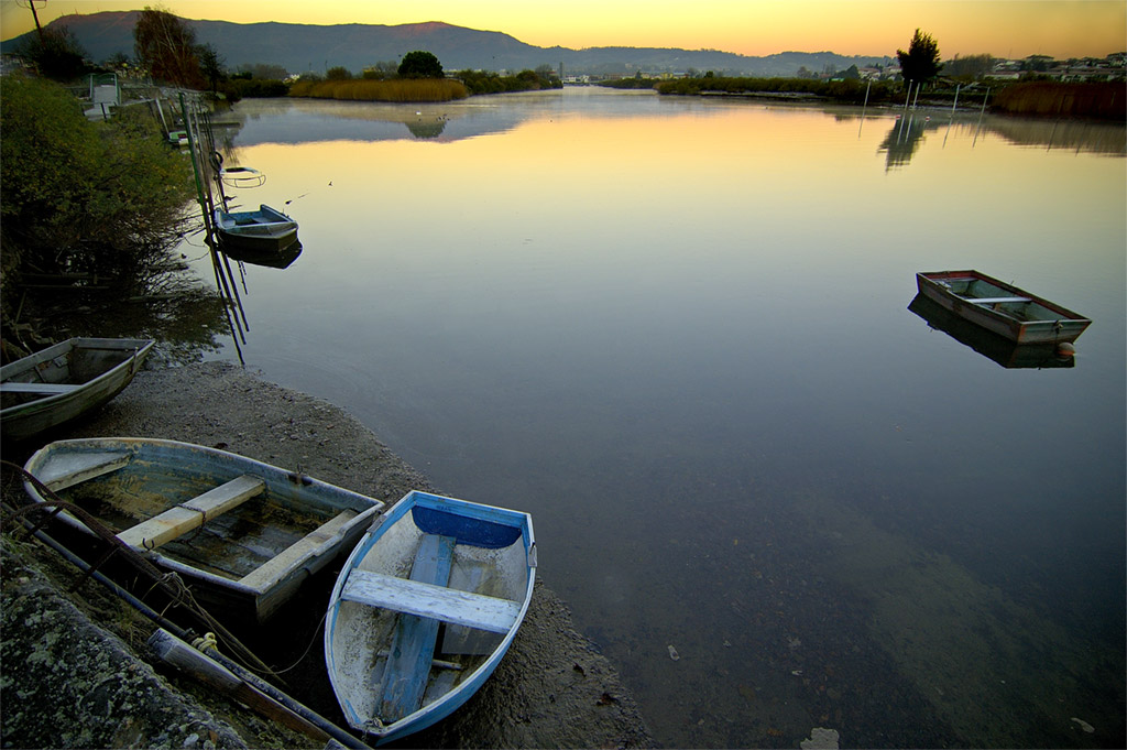
The Bidasoa (Basque: [bi'd̪as̺oa]; Spanish: [biða'soa]; French: Bidassoa,[2] pronounced [bidasɔa]) is a river in the Basque Country of northern Spain and southern France that runs largely south to north. Named as such downstream of the village of Oronoz-Mugairi (municipality of Baztan) in the province of Navarre, the river actually results from the merger of several streams near the village Erratzu, with the stream Baztan that rises at the north-eastern side of the mount Autza (1,306 m) being considered the source of the Bidasoa. It joins the Cantabrian Sea (Bay of Biscay) between the towns of Hendaye and Hondarribia.

The airport, Txingudi, the SNCF facilities in Hendaye, Irun in the distance and the Santiago Bridge spanning the borderline

The river is best known for establishing the borderline at its lower tract.[3] This stretch is crossed not only by aircraft at low height but by important European communication axes, namely AP8 E5 E80 - E70 A63 (motorway, connection at the Biriatu toll), main roads N1 - N10 (connection at the roundabout of Saizar by the river) and major French and Spanish railway networks,[3]Renfe and SNCF. Besides these major lines, other regional ones cross it too, e.g. regional railway EuskoTren (terminus in Hendaye)[3] and another double bridge (pedestrians/vehicles) joining the towns on the border, i.e. the historical Santiago Bridge (Way of St. James). At this stage of the river, urban landscape prevails (built-up area).

Before pouring its waters into the ocean, it forms a bay called Txingudi located between these towns and Irun,[3] the site being designated Wetland of International Importance in 2002, with a total area of 1.28 km2 (0.49 sq mi). The banks of Hondarribia hold the minor San Sebastian Airport serving domestic flights[3] and currently mired in controversy over its lengthening and upgrading scheme.

Pronunciation and etymology

[edit]

The river comprises an area of linguistic contact, so it is pronounced differently depending on the language, namely [biˈd̪as̺oa] in Basque, [biðaˈsoa] in Spanish, and [bi'dasoa] in French. Linguistic and historic research point to the name stemming from Latin phrase "Via ad Oiassonem" (later corrupting into Basque "Bidasoa") on account of the road that linked at Roman times Basque town Pompaelo with Oiasso, which may have run along the river.

Course of the river and tributaries

[edit]
The Bidasoa at Elizondo

The Bidasoa flows through much of its 66 km (41 mi) length over Navarrese territory, except for the last 10 km (6.2 mi), where it establishes the borderline between France and Spain, as well as the boundary between the Basque provinces of Gipuzkoa and Labourd. In line with the distribution of the river's length, the bulk of its watershed's area lies on Navarre (684 km2 or 264 sq mi). The basin holds 105 permanent streams and rivers that number 497 km (309 mi), the region being drenched in rains regularly. The Navarrese side of the basin (rural landscape) is inhabited by 22,000 inhabitants. 70% of its population have the sewage treated before spilling to the river.

But for the first 15-odd kilometres, the river clings to the north to south disposition of other neighbouring rivers of Gipuzkoa joining the Bay of Biscay, e.g. Urumea, Oria, etc. Strengthened by the waters harvested from the sides of the pass of Belate, downstream of Doneztebe the river heads north and crosses the town of Bera at the north end of Navarre before entering Gipuzkoa at Endarlatsa. From the town of Doneztebe on, the main road N-121 runs along till the roundabout across the river from the toll of Biriatu by the AP-8 (motorway). Next comes the quarter Behobia and the major towns on the shores of the estuary.

The main tributaries of the Bidasoa are the minor rivers Zeberia (length 10.80 km (6.71 mi)), Ezkurra (20.90 km (12.99 mi)), Latsa (11.10 km (6.90 mi)) and Endara (9.90 km (6.15 mi)). Additionally, further small rivers and streams feed the Bidasoa all along.

Fishing and environmental challenges

[edit]
Aerial view of the Bidasoa's mouth and Txingudi
Cohaya on the Bidassoa (in Spain) by Edward Hawke Locker in 1824, published in the work Views in Spain
Bidassoa confluence in Fontarrabie, in 1843 by Eugène de Malbos

The Navarrese tract of the river is a preferred destination for fishing enthusiasts, the river being home to several native fish species, namely eel (Anguilla anguilla), salmon (Salmo palar), trout (Salmo trutta), bullhead (Cottus gobio), Barbatula barbatula, Phoxinus phoxinus, gudgeon (Gobio lozanoi), sea lamprey (Petromyzon marinus), allis shad (Alosa alosa), flounder (Platichthys flesus) and grey mullet (Chelon labrosus), some of them declared endangered species and highly interesting (especially bullhead and salmon).[4] Moreover, a species of the Ebro, Chondrostoma miegii, has been introduced in the last 30–40 years on the lower tract of the Bidasoa, thereafter extending gradually upstream.

As a result, overfishing has become a major problem for the river's fauna, with special pressure put on salmon migrating upstream to spawn. They do not make it to their goal and die before spawning, either falling prey to fishers' bait or an inability to overcome hydroelectric power stations (128 over all the course) and the 114 related dams, since 63% of them prevent migratory fish from achieving their purpose. Schemes by the Regional Government of Navarre are underway with a view to handling the issue.

See also

[edit]

Footnotes

[edit]

References

[edit]
Revisions and contributorsEdit on WikipediaRead on Wikipedia
from Grokipedia
The Bidasoa is a river originating in the of northern , where the Izpegui and Iztauz streams converge near the village of Erratzu, and extending approximately 66 kilometres northward to its mouth at the Bay of Txingudi, which opens into the . Flowing predominantly through the Spanish region of for most of its course, the Bidasoa delineates the international boundary between and France along its final 10 kilometres, separating the towns of and Hondarribia from . This border-forming stretch holds historical prominence due to the 1659 , which established condominium over () in the river's estuary, alternating sovereignty between and every six months—a unique arrangement symbolizing Franco-Spanish reconciliation after prolonged conflict. The river's valley supports local , , and recreational activities such as , while its estuarine contributes to in the Txingudi wetlands, though subject to tidal influences and cross-border management. No major engineering feats like large dams mar its natural flow, preserving its role as a relatively unaltered transboundary .

Geography

Location and Course

The Bidasoa is a river in the Basque Country that originates in the western Pyrenees mountains of Navarre, Spain, and flows predominantly northward for 66 kilometers, discharging into the Bay of Txingudi near the border with France. Its source lies in the Astaté area near the village of Erratzu, formed by the confluence of the Izpegui and Iztauz streams at an elevation of approximately 800 meters. The river's upper course traverses the Baztan Valley, passing through municipalities such as Elizondo, where it is also known locally as the Baztan River before adopting the name Bidasoa downstream. It continues through Navarrese territory, including areas around Sunbilla and Leizalde, before entering the province of near . For most of its length, the Bidasoa remains within Spanish borders, but its final 10 kilometers mark the international boundary between and , separating from . The river empties into the Bay of Txingudi at 43°22′22″N 1°47′31″W, forming an shared by both countries.

Basin and Tributaries

The Bidasoa River basin covers an area of 710 km², predominantly in the Spanish region of , with minor extensions into province and the . The basin's perimeter measures 153 km, enclosing a rugged in the western foothills characterized by steep slopes and high annual precipitation exceeding 1,500 mm in upper areas. This supports a dense network of waterways, including the main 75.4 km channel and 477.2 km of tributaries, totaling 552.5 km of river courses. Key tributaries contribute significantly to the Bidasoa's flow, with the Ezkurra River recognized as the primary one by discharge volume, joining near Doneztebe-Santesteban after receiving inputs from the Ezpelura. Other notable left-bank tributaries include the Latsa, Tximista, Ezpelura, Txaruta, and Zeberia rivers, which drain sub-basins in the Baztan Valley and surrounding highlands. Right-bank affluents such as the Endara and Onin further augment the system, with recent dam removals on the Onin enhancing connectivity for migratory species like . These streams originate from elevations up to 710 m at the Bidasoa's headwaters near Erratzu, where the Izpegui and Iztauz unite to form the initial Baztan segment.

Hydrology

Flow Regime and Discharge

The Bidasoa River displays a hydrological regime typical of northern Iberian Atlantic basins, where discharge is predominantly influenced by rather than , resulting in pronounced seasonal and interannual variability. The basin's , with annual rainfall averaging 1,500–2,000 mm, drives higher flows during the wetter autumn and winter months (), when monthly average discharges can reach 40 m³/s, contrasted by summer minima around 10 m³/s due to reduced and increased . The long-term average annual discharge, measured near the at gauging stations such as Endarlatsa or Legasa, is approximately 24–25 m³/s, reflecting a specific runoff of about 35 L/s/km² over the 710 km² basin. Instantaneous peak flows during extreme events, such as storms, have exceeded 1,400 m³/s, as recorded in December 1993 at Endarlaza, while low-flow conditions can drop to 3 m³/s during prolonged dry spells. Limited regulation from upstream reservoirs, such as those at Arteaga or Leizalde, moderates but does not fully alter the natural variability, preserving the river's flashy response to rainfall events; however, abstractions for and urban use in the lower basin reduce effective discharge by an estimated 10–15% below unregulated levels. This regime supports migratory fish species like but poses flood risks in the transboundary , where tidal influences interact with fluvial peaks.

Climate Influences

The Bidasoa River's is predominantly influenced by its pluvial-oceanic regime, driven by the humid Atlantic climate of the Basque region, where is the primary control on discharge variability. Annual rainfall in the basin averages 1,700–1,900 mm, with higher values in upstream areas exceeding 1,900 mm and the portion recording 1,869 mm per year, contributing approximately 78 hm³ of water annually to that sub-basin. This abundant, year-round peaks in autumn and winter—particularly —leading to elevated runoff and flood-prone high flows, as evidenced by historical events like those in , , and triggered by intense seasonal storms exceeding 100 mm in a day. Seasonal discharge patterns reflect these climatic drivers, with mean monthly flows ranging from minima of about 9 m³/s in summer to maxima over 150 m³/s during winter peaks, yielding an annual average of 24.7 m³/s across the 710 km² basin. Lower summer discharges result from reduced rainfall combined with higher under mild oceanic temperatures (typically 10–15°C annually in lowland areas), which diminish effective runoff without significant nival contributions given the river's modest (source at 710 m). Prolonged dry spells and elevated temperatures exacerbate low flows, as observed in 2022 when minimal reduced the river to critically low levels, increasing stagnation and ecological stress. The specific discharge of around 39.4 l/s/km² in the section underscores the basin's high hydrological yield from , though variability amplifies flood risks during intense frontal systems common to the region's westerly winds.

Name and Etymology

Linguistic Origins

The name Bidasoa derives from the Latin phrase via ad Oiassonem, translating to "the road to Oiasso," referencing the ancient Vasconian of Oiasso near the river's at present-day and Hondarribia. This etymology reflects the river's role as a key access route during Roman times, with the Latin form evolving through phonetic corruption into medieval Basque Bidasso or Bidasoa. Linguistic analyses trace the transformation via intermediate forms like Bidassoa in French and Bidasoa in Spanish and Basque, preserving the directional sense tied to the historic path leading to the settlement. While the core origin links to Roman nomenclature, some interpretations incorporate Basque elements, such as bide ("path" or "way") as a prefix, potentially reinforcing the "route" in the pre-Roman substrate of the region. However, no direct pre-Latin Basque attestation exists for the full name, and the Oiassonem component aligns with Aquitanian personal names and toponyms documented in Roman sources, indicating Vasconic roots predating Latin overlay. This hybrid formation underscores the linguistic layering in the Basque Country, where indigenous non-Indo-European terms interacted with imperial Latin influences from the CE onward.

Historical Naming Variations

The Bidasoa River's name exhibits variations primarily reflecting linguistic and orthographic differences across Basque, Spanish, and French usage, with consistent attestation from at least the . In Basque and Spanish contexts, the standard form Bidasoa (or Río Bidasoa) predominates, denoting the waterway from its entry into province downstream to the Bay of Txingudi. The upstream segment, originating in , has historically been designated the Baztán River until it assumes the Bidasoa name near Oronoz-Mugairi. French-language references employ Bidassoa, as seen in diplomatic and navigational documents, including mid-20th-century international agreements regulating and on the river, which fall under the jurisdiction of the vessel's originating country. Earlier historical records, compiled by the (Royal Academy of the ), document orthographic shifts such as vidasoa for a along the river (attested 1768–1862) and bidassoa in a French-designated quartier (1756–1815), alongside the modern bidasoa by 1857. These variations underscore the river's role as a Franco-Spanish , where bilingual administrative practices influenced spelling without altering the core . No distinct medieval or ancient riverine name is attested independently of its etymological ties to nearby Roman settlements, though post-Roman corruptions stabilized the form by the .

History

Ancient and Medieval Periods

The region encompassing the Bidasoa River was settled by pre-Roman peoples, including the , whose presence is attested from the AD in Roman records of Basque-area cities. During the Roman period, beginning around the AD, the area hosted operations, as evidenced by geochemical and micropalaeontological signatures of lead ratios matching Roman-era Iberian districts. Archaeological findings include remnants of a on (known anciently as Pausoa, meaning "passage" in Basque), indicating the river's role in early infrastructure for trade and military movement along the coast. The river's name likely originates from the Latin "Via ad Oiassonem," referring to a leading to Oiasso, a Vascon-Roman at the Bidasoa near modern , underscoring Roman integration of local Basque routes for commerce. In the early medieval period, following the fall of the , the Bidasoa area fell under Visigothic influence but retained Basque autonomy amid fragmented control by , , and later Muslim incursions from 711 AD onward. By the 9th century, the valley integrated into the emerging , founded circa 824 AD under Iñigo Arista, where it provided vital maritime access via the estuary, distinguishing Navarre from landlocked inland realms. Navarrese kings fortified border towns like Vera de Bidasoa as defensive outposts against French and Castilian incursions, leveraging the river's strategic position. In 1200 AD, Navarre risked permanent loss of sea outlet when seized and Alava, constricting Bidasoa access and prompting fortified responses in the valley. Medieval governance included feudal assemblies, such as the Baztan Valley's of medieval origin, which administered communal lands and customs in the Bidasoa-Baztan area, preserving Basque legal traditions amid monarchical shifts.

Establishment as International Border

The Bidasoa River's role as an international border between and was formalized by the , signed on November 7, 1659, which concluded the Franco-Spanish War that had raged since 1635. This agreement delineated the frontier along the summits of the from the to the , with the Bidasoa designated as the boundary line in its lower reaches, separating Spanish from French (now part of ). The treaty's border provisions resolved longstanding ambiguities in the western , where prior divisions—such as the 1512–1527 partition of the Kingdom of Navarre between Castile and —had left fluid territorial claims without precise demarcation. Negotiations culminated on , a small in the Bidasoa's midstream near its mouth, chosen for its neutral position equidistant from the of and the French town of . The island's selection underscored the treaty's diplomatic symbolism, as it lay beyond entrenched positions on either bank. Article 42 of the treaty explicitly traced the western border segment along the Bidasoa from the sea upstream to the foothills, integrating natural features like the river to minimize future disputes while ceding territories such as to France in exchange for Spanish retention of areas south of the Bidasoa. This riverine alignment leveraged the Bidasoa's consistent south-to-north flow and estuarine geography for enforceability. Subsequent surveys and minor adjustments, including the 1856 Treaty of , refined demarcation points along the Bidasoa but preserved its core status as the divide, with customs posts and fortifications erected soon after 1659 to assert . The establishment marked a shift from feudal overlordships to absolutist state borders, prioritizing geographic stability over ethnic or linguistic continuities in the Basque-crossing valley.

Modern Developments and Conflicts

During Francisco Franco's dictatorship (1939–1975), the Bidasoa border was militarized on the Spanish side, with guards stationed every 100 meters along the river to prevent unauthorized entries and enforce isolation from France. The Basque separatist group ETA, active from 1959 to 2018, utilized the Bidasoa region as an escape route, with local mugalari—smugglers experienced in navigating the river and surrounding terrain—guiding militants across into France, where sanctuary was initially available until French authorities intensified cooperation with Spain in the 1980s. Spain's accession to the in 1995 eliminated routine frontier checks, reducing overt border tensions but not eliminating illicit activities. Since 2018, French restrictions on migrant entries have prompted irregular crossings of the Bidasoa by sub-Saharan African migrants evading Spanish policies, leading to at least 10 deaths in 2018–2019 and further fatalities thereafter, including seven drownings between April 2021 and October 2021 from attempts to swim or wade the river between and . Contemporary smuggling networks, building on historical cross-border trade, now facilitate amid these migration flows, complicating Franco-Spanish coordination despite shared EU frameworks.

Border and Political Significance

Pheasant Island and Sovereignty Alternation

, situated in the Bidasoa River between the French municipality of and the Spanish municipality of , spans approximately 2,000 square meters and remains uninhabited. As the world's smallest , it operates under joint Franco-Spanish , with administrative control alternating semiannually to symbolize perpetual peace following historical border disputes. The arrangement originated with the , signed on November 7, 1659, on the neutral to conclude the and delineate the as the primary border, with the Bidasoa River marking the western endpoint. Negotiators selected the island for its equidistant position, avoiding territorial concessions during talks led by for and Luis Méndez de Haro for . The treaty explicitly provided for alternating sovereignty, starting with Spanish control, to prevent unilateral claims and reinforce mutual recognition of the border. In 1660, on June 5 and 6, King Louis XIV of and King met on the island to ratify the treaty and arrange the marriage of Louis to Philip's daughter, , further cementing the peace. Under the protocol, sovereignty transfers from to on and reverts to Spain on February 1 annually, with holding from August through January and from February through July. These handovers occur without in modern times, often documented administratively between local authorities, as the island hosts no residents, infrastructure, or economic activity. Public access is restricted to preserve its status, though occasional maintenance or historical commemorations allow brief visits by officials. An erected in 1861 commemorates the 1659 treaty and 1660 royal meeting, standing as the island's sole notable feature amid overgrown vegetation. This unique arrangement underscores the treaty's enduring emphasis on symbolic equity over practical division, with no recorded disputes over implementation since 1659, reflecting stable bilateral relations along the Bidasoa sector. Despite its irrelevance to contemporary border management—handled via cooperation—the alternation persists as a vestige of 17th-century , occasionally highlighted in diplomatic exchanges.

Cross-Border Management and Cooperation

The Bidasoa River's role as a transboundary is managed through bilateral mechanisms established by and , primarily the Comisión Técnica Mixta del Bidasoa, an advisory organ under the International Commission of the . Created via a protocol signed on December 14, 1978, and effective from March 1, 1979, this commission handles technical coordination on hydraulic works, water utilization, pollution prevention, and border maintenance along the river. Its activities include periodic meetings to resolve disputes over infrastructure and resource allocation, ensuring equitable use amid shared ecological pressures. Complementing this, a 2006 Administrative Agreement on Water Management governs the basin's transboundary aspects, with a co-chaired by the French Ministry of Ecological Transition and Spain's Ministry for the Ecological Transition and Demographic Challenge. This framework supports joint monitoring of , flood risk assessment, and implementation of the , addressing the Bidasoa as a sub-basin linking France's Adour-Garonne and Spain's Norte I . Cooperation has intensified since 2010, incorporating data exchange on hydrological modeling and restoration efforts to mitigate upstream dam impacts. Local-level collaboration focuses on the Lower Bidasoa area, where the 1998 Bidasoa-Txingudi consortium unites the municipalities of and Hondarribia (Spain) with (France) for integrated planning around Txingudi Bay. This intermunicipal body advances joint initiatives in environmental conservation, transport infrastructure, and , such as shared and promotion, funded partly through EU programs. Despite achievements in mobility and cultural exchanges, persistent challenges include aligning regulatory frameworks and securing sustained financing, as noted in evaluations of cross-border efficacy.

Role in Conflicts and Migration

The Bidasoa River has served as a strategic frontier in several military engagements due to its position as the France-Spain border. During the Peninsular War, Allied forces under Arthur Wellesley, Duke of Wellington, crossed the river on October 7, 1813, in the Battle of the Bidassoa, overrunning French defensive lines along the coast and Pyrenees crest to invade southwestern France; this maneuver involved approximately 70,000 troops advancing against 35,000 French defenders, resulting in around 1,600 French casualties compared to 600 Allied losses. Earlier, in the 1808-1813 Napoleonic occupation of Spain, French armies transited the Bidasoa crossing in October 1807 as part of their invasion, initially received as allies but soon viewed as occupiers by local populations. The nearby Battle of San Marcial, fought on August 31, 1813, along the Bidasoa near Irun, pitted up to 40,000 combatants in a Spanish defense against French assaults, marking a key repulsion that contributed to the broader Allied campaign. The river's border role extended to earlier conflicts, such as the , where French-Navarrese forces captured Fuenterrabia (modern Hondarribia) at the Bidasoa's mouth in September 1521, leveraging the waterway for amphibious approaches before Spanish counteroffensives reclaimed the town. Under Francisco Franco's dictatorship from 1939 to 1975, the Bidasoa was heavily fortified with sentries positioned every 100 meters to prevent unauthorized crossings, reflecting its use as a barrier against escapes and amid post-Civil War isolation. In contemporary times, the Bidasoa has become a conduit for irregular migration, particularly since 2020, as migrants from and sub-Saharan regions attempt northward passage from to France amid tightened Schengen controls. By August 2021, over 4,100 undocumented crossings were recorded that year, with methods including foot, vehicle, and increasingly hazardous swims across the shallow but swift river, driven by French pushbacks and profiling at formal posts. At least 11 migrants drowned in such attempts between 2021 and 2023, including a documented case on August 8, 2021, near , underscoring risks from currents and poor visibility despite the river's average 20-50 meter width. Local NGOs estimate up to 30 arrivals daily seeking transit, often from former French colonies, highlighting the Bidasoa's shift from military frontline to a perilous migration route within the EU's internal borders.

Ecology and Biodiversity

Native Flora and Fauna

The Bidasoa River basin supports a diverse array of native riparian and wetland flora, dominated by deciduous woodlands and marsh vegetation adapted to its Atlantic climate and varying hydrology. In the upper valley, particularly within the Señorío de Bertiz Natural Park, mixed forests feature beech (Fagus sylvatica), Atlantic oak (Quercus robur), and European ash (Fraxinus excelsior), alongside understory species that contribute to soil stabilization and habitat connectivity. Riparian zones are characterized by alder (Alnus glutinosa) galleries, which play a key role in erosion control, nutrient cycling, and maintaining ecological balance along the riverbanks. In the lower estuary at Txingudi Bay, halophytic and emergent wetland plants prevail, including common reed (Phragmites australis) beds and salt-tolerant species in tidal marshes, forming critical buffers against sedimentation and supporting transitional habitats between freshwater and marine environments. Native fauna in the Bidasoa ecosystem reflects its position as a migratory corridor and wetland refuge, with semi-aquatic mammals such as the (Lutra lutra) and (Mustela lutreola) inhabiting riparian corridors for foraging and shelter, though both face pressures from . Avian diversity is pronounced, especially in Txingudi wetlands, where breeding and wintering species include the (Ardea cinerea), (Alcedo atthis), (Cinclus cinclus), (Anas platyrhynchos), and (Motacilla cinerea), alongside rarer breeders like the aquatic warbler (Acrocephalus paludicola) and common spoonbill (Platalea leucorodia). Forested upper reaches host all seven Iberian woodpecker species, underscoring the valley's role in preserving woodland . Native fish assemblages feature (Salmo salar) and (Salmo trutta), which migrate through the river for spawning, though populations have declined due to barriers and exploitation. Reptiles, including pond turtles and water snakes adapted to riparian edges, further enhance the , linking aquatic and terrestrial components.

Salmon and Trout Populations

The Bidasoa River supports populations of (Salmo salar) and (Salmo trutta), both native salmonids integral to the basin's ecology. returns have fluctuated, with historical estimates of 250–500 adults annually in the Navarra section, though recent monitoring indicates variability and overall low abundance. In 2019, a minimum of 441 adults ascended the river, comprising 78% one-sea-winter (1SW) individuals and 22% multi-sea-winter (MSW), with a of approximately 2 males per female and an estimated 563,889 eggs produced by females. By 2022, counts dropped to 90 adults (36 females), recovering somewhat to 308 adults (71 females) in 2023, yet remaining in a critical below the favorable limit of 700 spawners but above the critical threshold of 150. Juvenile densities in 2019 averaged 10.04 individuals per 100 m², classified as moderate, with stable adult trends around 400–450 in prior years but declines in average size (10% length reduction and 29% weight loss for 1SW salmon since the 1990s). Brown trout populations in the Bidasoa exhibit both riverine (potamodromous) and sea-run (anadromous) forms, with the latter contributing to migratory dynamics. Over a 25-year monitoring period, restoration efforts—including enhancements and barrier removals—have positively influenced and riverine abundances, though specific density metrics vary by site. In the Baztan-Bidasoa basin, adult densities remain medium, positioning it among Navarra's better-conditioned waters alongside the Oria-Urumea system, with recent improvements enabling limited catch-and-release after prior restrictions. Annual surveys in Navarra, including 2019 assessments at sites like Elbete, track size structures and overall status, revealing resilience compared to amid shared pressures such as flow and variability. Both species face anthropogenic threats, but populations show greater vulnerability due to higher mortality and straying rates, with genetic studies indicating local adaptations in Iberian rivers like the Bidasoa. Conservation measures, including repopulation of over 94,000 alevins and three removals by 2019, aim to bolster connectivity and reproductive success for these salmonids.

Environmental Management

Dam and Barrier Impacts

The Bidasoa River basin features numerous small-scale , weirs (azudes), and barriers, primarily associated with historical water mills, , and minor hydroelectric operations, which have fragmented the longitudinal connectivity of the . These structures obstruct the natural flow of water, sediments, and biota, leading to altered hydrological regimes that reduce peak flows during floods and stabilize base flows, thereby diminishing the river's dynamic variability essential for . Prior to extensive removal efforts, such barriers rendered significant portions of the upstream basin inaccessible, with estimates indicating that up to 500 water use permits were linked to obsolete obstacles impacting over 100 kilometers of river length. Ecological impacts are pronounced on migratory fish, particularly (Salmo salar) and (Salmo trutta), whose anadromous life cycles require unobstructed access to spawning grounds. Dams and weirs create migration delays, increased mortality from entrainment in turbines or failed passage attempts, and habitat isolation, contributing to population declines; for instance, pre-restoration barriers blocked from reaching key tributaries, exacerbating fragmentation effects compounded by flow alterations and elevated water temperatures downstream. Research on the Bidasoa demonstrates that these obstacles reduce juvenile smolt outmigration success and adult upstream passage, with modeling showing delays that heighten predation risks and energy expenditure, ultimately limiting reproductive output. (Anguilla anguilla) populations face similar barriers to catadromous migration, further straining in this transboundary . Sediment trapping by reservoirs behind has led to downstream and channel incision, degrading gravel bed habitats critical for redds (spawning nests), while upstream impoundments promote and altered cycling, fostering proliferation over native riparian . These anthropogenic pressures, documented in basin management plans, have historically prevented the Bidasoa from achieving good ecological status under the EU , with barriers cited as primary drivers of biotic integrity loss. Although some barriers provide localized flood control benefits, empirical studies prioritize their removal for restoring natural processes, as evidenced by post-demolition increases in accessibility and habitat reconnection in treated reaches.

Pollution Control and Restoration Efforts

The Bidasoa and river basin faced substantial from industrial effluents and untreated urban until the late 1990s, contributing to degraded and with such as lead, , and . control measures, including the construction of plants and comprehensive infrastructure, were implemented across the Basque Country and Navarra regions starting in the late 20th century, aligning with directives on urban . These interventions reduced point-source discharges significantly, fostering a sustained trend observable in and metrics, with now classified as a minor stressor in most Bidasoa stretches. Post-mitigation restoration initiatives have emphasized physical habitat reconnection and ecological recovery to address legacy impacts. The EU-funded IrekiBAI project (2015–2020), coordinated by the Provincial Council with partners including Navarra's water agency and totaling €3 million in budget (of which €1.8 million from ), targeted the Bidasoa basin among shared transboundary rivers, removing 10 obsolete barriers to migration, enabling passage at two additional structures, demolishing spanning over 7 km, and rehabilitating 1.5 hectares of derelict industrial land into naturalized riparian zones. This effort substantially improved overall ecological status, enhancing connectivity for diadromous species like (Salmo salar) and (Salmo trutta) in Natura 2000-designated sites such as Río Bidasoa (ES2200014). Key actions included the 2016 demolition of the San Martín (Bera) Dam—the third barrier, measuring 2.85 m high and 102.84 m long—as part of a series of three removals conducted between 2014 and 2016 to restore longitudinal connectivity and dynamics. These measures have yielded positive short- to medium-term responses in populations, with monitoring over 25 years indicating improved riverine densities attributable to barrier elimination, though full benefits require sustained management amid variable hydrological conditions. Further removals in Bidasoa tributaries, completed by 2022, and planned passes underscore ongoing bilateral cooperation between and to bolster resilience against residual anthropogenic pressures.

Human Utilization

Economic Activities

The economy of the Bidasoa valley centers on and rearing, which maintain a strong traditional presence alongside emerging sectors like and services. Local production includes talos (corn tortillas), fresh curd, and , the latter protected by a designation of origin that underscores the region's heritage of in mountainous pastures. These activities support small-scale operations, though the valley has experienced de-agriculturalization trends, with a shift toward diversified in and industry concentrated in towns like Bera and Elizondo. Tourism plays an increasingly vital role, driven by the valley's natural landscapes, greenways, and cross-border appeal, fostering rural accommodations, active pursuits such as and along the river, and gastronomic experiences tied to local produce. The Bidasoa Greenway, repurposed from disused rail infrastructure, exemplifies infrastructure that draws visitors for low-impact recreation without overburdening the environment. Proximity to France enhances this sector through consolidated holiday destinations emphasizing and eco-tourism, though population stagnation limits broader growth. Recreational fishing for (Salmo salar) and (Salmo trutta) provides seasonal economic contributions, regulated under strict permits to aid species recovery; approximately 400 adult salmon return annually to spawn, supporting tourism amid ongoing restoration. Historical cross-border commerce, including along the river until the late , has evolved into legal trade facilitated by the valley's strategic location, with public initiatives like Bidasoa Activa promoting job generation and industrial parks.

Cultural and Recreational Uses

The Bidasoa River supports a range of recreational water sports, including , canoeing, and stand-up (SUP), with popular descent routes spanning approximately 7.5 kilometers from Endarlatza to Behobia or , typically lasting 2.5 to 3 hours and suitable for intermediate participants. These activities allow participants to navigate mild rapids while observing the river's border-crossing landscape between and . Recreational fishing targets species such as and in designated areas, drawing anglers to the river's upper and middle reaches, though regulated by seasonal quotas and licenses to sustain populations. Land-based pursuits include and along riverside paths, such as those in the Txingudi Bay area, which connect to broader trails offering views of wetlands and migratory bird habitats. Picnicking, , and informal swimming occur at accessible spots like natural pools, enhancing the river's appeal for casual leisure amid its ecological setting. Culturally, the Bidasoa demarcates the France-Spain border and hosts (Île des Faisans), a tiny landform in its that alternates sovereignty between the two nations every six months under the 1659 , symbolizing diplomatic reconciliation and rarely accessible to the public except during select historical commemorations. The river's valley preserves Basque linguistic and traditional elements, with its name possibly deriving from the Basque "bide" (path) linked to ancient settlements like Oiasso, integrating into regional heritage trails that highlight Navarrese and Gipuzkoan customs. Cross-border ferries from to Hondarribia facilitate cultural tourism, enabling visits to fortified sites and festivals that underscore the river's role in shared Franco-Basque identity.

References

Add your contribution
Related Hubs
User Avatar
No comments yet.