Hubbry Logo
Sirena DeepSirena DeepMain
Open search
Sirena Deep
Community hub
Sirena Deep
logo
8 pages, 0 posts
0 subscribers
Be the first to start a discussion here.
Sirena Deep
Sirena Deep
from Wikipedia

12°3.924′N 144°34.868′E / 12.065400°N 144.581133°E / 12.065400; 144.581133

Location of the Mariana Trench in the western Pacific Ocean
GEBCO 2019 bathymetry of the Challenger Deep and Sirena Deep.
(a) Mariana Trench multibeam bathymetry data gridded at 75 m acquired on‐board the DSSV Pressure Drop overtop the GEBCO 2019 source grid (as shown in Figure 1) and the complete GEBCO 2019 grid with hillshade. EM 124 black contours at 500 m intervals, GEBCO 2019 grey contours at 1,000 m intervals. The white circle indicates the deepest point and submersible dive location, the white triangle indicates the submersible dive location from Sirena Deep, the red spot was the deepest point derived by van Haren et al., (2017).
(b) Challenger Deep.
(c) Sirena Deep.
Bathymetric cross sections A’–A” and B’–B” over Challenger Deep and Sirena Deep displayed in (d) and (e), respectively.

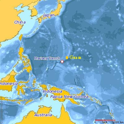
The Sirena Deep, originally named the HMRG Deep, was discovered in 1997[1][2] by a team of scientists from Hawaii.[2] Its directly measured depth of 10,714 m (35,151 ft) is third only to the Challenger Deep and Horizon Deep, currently the deepest known directly measured places in the ocean.[3][4][5] It lies along the Mariana Trench, 200 kilometers to the east of the Challenger Deep and 145 km south of Guam.[1][2]

Formation

[edit]

The Sirena Deep was most probably formed, not through transform fault motion as previously thought, but through a north-south convergence of the Caroline plate and the Pacific plate, in which the Caroline plate is subducting.[3] A group of scientists have hypothesized that the great depth of the Mariana Trench, the Challenger Deep, and the Sirena Deep is due to a tear in the subducting Caroline plate, causing deformation of the Pacific plate above.[3] This tear would be located to the south of Guam, the same location of the deepest portion of the Mariana Trench.[3] The tear would lead to unusual regional tectonics, another possible reason for the extreme depth.[3] Scientists were alerted to the presence of the tear by the depth of strike-slip earthquakes, which were occurring too deep for them to be in the overriding plate.

The Sirena Deep lies at the intersection of the East Santa Rosa Bank Fault and a trench axis south of Guam.[3]

History

[edit]

Discovery

[edit]

In 1997, the Hawaiʻi Mapping Research Group (HMRG) conducted a detailed sonar survey of the seafloor around Guam, discovering what is believed to be the second or third deepest[4][5][6] location in the world's oceans; its existence was confirmed in 2001 and it was temporarily named HMRG Deep.[2][6] In the same research mission, scientists found previously undiscovered faults, landslides, and mud volcanoes.[2]

The data that confirmed the discovery were collected using the HAWAII MR1 mapping system. This mapping system has the ability to record both bathymetry and sidescan data at the same time. The two vessels that this system was used on were RIV Moana Wave in 1997 and RIV Melville in 2001.[3]

Renaming

[edit]

After a competition was held in 2009 by Patricia Fryer, her doctoral student Sam Hulme, and Linda Tatreau to rename the HMRG Deep,[6] the new name of Sirena Deep was chosen. Students from Guam and the Northern Mariana Islands ages 18 and younger competed,[6][7] with the winning name being suggested by Jermaine Sanders (aged 16) and John Meno (aged 14). The new name references the Guam folk-tale of Sirena, a young girl turned into half fish because of her disobedience.[8] The new name will now appear on geologic and bathymetric maps.

Crewed descent

[edit]
Deep Submersible Support Vessel DSSV Pressure Drop and DSV Limiting Factor at its stern

On 7 May 2019 Victor Vescovo (Pilot) and Alan Jamieson (Chief Scientist) made the first crewed descent to the bottom of the Sirena Deep in the Deep-Submergence Vehicle Limiting Factor (a Triton 36000/2 model submersible) and measured a depth of 10,714 m (35,151 ft) ±10 m (33 ft) by direct CTD pressure measurements. This descent occurred just after descending four times to the bottom of the nearby Challenger Deep. Work focused on geological, biological and video survey and collection in the Mariana Trench basin. They spent 176 minutes on the bottom of the Sirena Deep and the deepest piece of mantle rock ever recovered from the surface of the western slope of the Mariana Trench was collected.[9][10] The Mariana Trench and the operating area was surveyed by the support ship, the Deep Submersible Support Vessel DSSV Pressure Drop, with a Kongsberg SIMRAD EM124 multibeam echosounder system. The gathered data will be donated to the GEBCO Seabed 2030 initiative.[11][12] The dive was part of the Five Deeps Expedition. The objective of this expedition was to thoroughly map and visit the deepest points of all five of the world's oceans by the end of September 2019, which was achieved.[13][14]

References

[edit]
[edit]
Revisions and contributorsEdit on WikipediaRead on Wikipedia
from Grokipedia
Sirena Deep is a profound depression within the in the western , situated approximately 90 miles (145 km) south of and about 200 kilometers (124 miles) northeast of . It plunges to a depth of roughly 10,700 meters (35,100 feet), classifying it among the deepest known sites on Earth's surface. Originally referred to as HMRG Deep—named after the Mapping Research Group—the feature was first identified in 1997 during bathymetric surveys conducted by University of scientists. It was later renamed Sirena Deep, evoking the mythical sirens of the sea, and has since become a key target for deep-sea research due to its extreme conditions, including pressures exceeding 1,000 times that at and near-freezing temperatures. Explorations of Sirena Deep have revealed a surprisingly resilient hadal adapted to such harsh environments. In 2011, researchers using remotely operated vehicles discovered giant xenophyophore amoebas, some up to 10 centimeters across, thriving at depths of 10,641 meters on the floor. A 2014 Schmidt Ocean Institute expedition collected amphipods—scavenging crustaceans—at around 10,500 meters, noting their swarms and unique biochemical adaptations like high concentrations of N-oxide (TMAO) to counteract hydrostatic . Further dives, including those from the 2019 Five Deeps Expedition reaching 10,780 meters and the 2021 Caladan Oceanic Expedition, have documented additional , such as worms and sea cucumbers, underscoring the 's role in studying life's limits under extreme . These findings highlight Sirena Deep's importance for advancing knowledge in geosciences, , and potential analogs.

Location and Physical Characteristics

Coordinates and Dimensions

Sirena Deep is situated at 12°3.924′N 144°34.868′E along the in the western . This position places it approximately 145 km south of and about 200 km northeast of , within the broader arc of the trench. The deepest point in Sirena Deep has been measured at 10,714 meters ±10 meters below , based on the first precise manned submersible dive conducted during the Five Deeps Expedition on May 7, 2019, piloted by with Dr. Alan Jamieson as chief scientist. This measurement confirms it as one of the deepest known locations on , surpassing earlier estimates from multibeam surveys. Sirena Deep is characterized by steep surrounding walls that contribute to its isolated bathymetric profile. It is located at the intersection of the East Santa Rosa Bank Fault and the axis, where tectonic interactions create this pronounced topographic feature.

Comparison to Other Depths

Sirena Deep ranks as the third deepest known point in Earth's oceans, with a measured depth of 10,714 meters, surpassed only by in the and Horizon Deep in the . This positioning underscores its extreme status among features, where pressures exceed 1,000 atmospheres and conditions challenge exploration technologies. Compared to , located approximately 200 kilometers to the west, Sirena Deep is 214 meters shallower, with Challenger reaching 10,928 meters during the same 2019 expedition. Both sites lie within the , sharing similar subduction-driven morphology but differing in local bathymetric relief; Sirena's floor features steeper walls and more pronounced talus slopes. In contrast, Horizon Deep, the second deepest point at 10,823 meters in the , exceeds Sirena Deep by 109 meters, highlighting subtle variations in trench axis depths across the Pacific subduction system.
Deepest PointLocationDepth (m)Source
10,928Five Deeps Expedition (2019)
Horizon Deep10,823Five Deeps Expedition (2019)
10,714Five Deeps Expedition (2019)
Sirena Deep forms part of the cluster of ultra-deep sites concentrated along the , where the five deepest ocean trenches—Mariana, Tonga-Kermadec, Philippine, Izu-Bonin, and Kuril-Kamchatka—account for the planet's most profound abyssal features due to intense tectonic convergence. This regional dominance illustrates how plate boundary dynamics amplify hadal depths, with the majority of points exceeding 10,000 meters confined to this seismically active belt.

Geological Formation

Tectonic Processes

The Sirena Deep is situated within the southern segment of the , a major zone where the Pacific Plate is primarily subducting westward beneath the overriding Philippine Sea Plate, including the Mariana microplate. This features oblique subduction, with the adjacent Caroline Plate also contributing to the regional dynamics through north-south oriented convergence and partial involvement in the process along the southern margin. The convergence rate varies between approximately 2 and 8 cm per year, driving the ongoing deformation that maintains the trench's structure. The extreme depth of Sirena Deep, reaching over 10,800 meters, arises from enhanced incision facilitated by a possible tear or slab window in the subducting Pacific Plate slab, which allows for greater rollback and steepening of the downgoing lithosphere. This tectonic feature, observed in the southern Mariana system, results from weak plate coupling over a narrow zone (about 50 km wide), contrasting with broader coupling in the central trench, and permits deeper penetration into the mantle. The slab tear, located near 144°E longitude, releases stress and promotes localized extension in the overriding plate, exacerbating the depth. Such mechanisms are part of the broader subduction dynamics that have sculpted the trench over more than 50 million years, since the initiation of Izu-Bonin-Mariana arc volcanism in the Eocene. Associated with these processes are nearby back-arc spreading in the Mariana Trough, where extension at rates of about 1.6 cm per year forms new behind the , and the development of the volcanic Mariana arc, including islands formed by rising from the subducting slab. These features highlight the active of the region, where hydration of the overriding mantle and slab dehydration contribute to and . The intersection with the East Santa Rosa Bank Fault may influence local stress regimes, but the primary depth control remains the subduction-induced .

Unique Features

One of the most distinctive geological aspects of Sirena Deep is the direct exposure of material at the seafloor, manifested as serpentinized . This , formed through the hydration and alteration of by hydrothermal fluids, indicates tectonic exhumation processes that bring deep-seated materials to the . Samples of intensely serpentinized , showing crystals altered to and iddingsite, were retrieved during dives, revealing mesh and hourglass textures typical of low-temperature serpentinization. During the 2019 Five Deeps Expedition, the first manned descent to Sirena Deep's floor included geological sampling efforts that further documented these exposures, enhancing prior observations from multibeam mapping and ROV surveys. Fault-related structures are prominent at Sirena Deep, where the trench axis intersects the East Santa Rosa Bank Fault, creating prominent scarps and a rugged that exposes fractured . These fault scarps, visible in high-resolution bathymetric data, facilitate the delivery of debris from the to the inner slope and may channel fluids responsible for serpentinization. Evidence of possible hydrothermal activity remnants includes veins of and within the , as well as chimneys composed of , , and , suggesting past low-temperature alkaline venting associated with mantle hydration. Such features underscore the site's role as a window into subduction-related , potentially influenced by a tear in the subducting slab. The characteristics at Sirena Deep consist of a thin layer of draping over the fractured ultramafic bedrock, with analyses of retrieved s showing biogenic silica from radiolarians and diatoms mixed with minor terrigenous input. This sparse cover, often less than a few centimeters thick in places, highlights the erosive and dynamic of the hadal environment, where tectonic activity limits sediment accumulation. The presence of ultramafic rocks like serpentinized also points to potential concentrations of rare earth elements, as these lithologies in settings can host accessory minerals enriched in such critical resources, though detailed assays remain pending further study.

Exploration History

Initial Discovery and Mapping

The Sirena Deep, initially known as the HMRG Deep, was first identified in 1997 during a seafloor mapping survey conducted by the Hawaii Mapping Research Group (HMRG) aboard the R/V Moana Wave in the Mariana Trench. Using the HAWAII MR1 seafloor mapping system, which combined sidescan sonar and digital bathymetry capabilities with swath widths up to 25 km, the team generated high-resolution imagery and data revealing a profound depression at approximately 10,732 m depth near coordinates 12°3.924′N, 144°34.868′E. This discovery highlighted structural complexities at the trench's western edge, including fault intersections contributing to extreme depths. A follow-up multibeam survey in 2001 aboard the R/V Melville refined the profile of the HMRG Deep, confirming its status as one of the 's deepest features with an estimated depth of around 10,677 m based on subsequent pressure-calibrated measurements and . These efforts produced detailed 16-m pixel sidescan grids and 100-m pixel maps, essential for delineating the site's topography and integrating into broader oceanographic analyses. The HMRG's datasets from these surveys were incorporated into global ocean floor compilations, enhancing models of morphology and dynamics. In 2009, the feature was renamed Sirena Deep to honor local marine heritage, though the original HMRG designation persists in some scientific contexts.

Renaming and Recognition

Originally known as HMRG Deep, after the Hawaiʻi Mapping Research Group that identified it during surveys from 1997 to 2001, the feature was renamed Sirena Deep following a 2009 competition organized by marine geologist Dr. Patricia Fryer of the , along with her doctoral student Sam Hulme and educator Linda Tatreau. The contest invited submissions from students aged 18 and younger in and the of the (CNMI) to propose a culturally resonant name, emphasizing the site's connection to local heritage. The winning entry, "Sirena Deep," was submitted by Jermaine Sanders, aged 16, and John Meno, aged 14, both from . The name draws from Chamorro folklore, where Sirena is a legendary figure—a young woman transformed into a mermaid-like siren as punishment for disobedience, often depicted as a guardian of the sea symbolizing the profound mysteries and allure of the ocean depths. This tale, rooted in Spanish colonial influences on Chamorro oral traditions from the late 1700s and documented in sources like the 1978 I Tetehnan manuscript, highlights themes of respect for nature and familial bonds. By selecting this name, the promoted educational outreach, engaging youth in ocean science and preserving indigenous narratives tied to the Mariana Archipelago's maritime identity. The renamed Sirena Deep gained official recognition in scientific shortly thereafter, appearing in international bathymetric charts and gazetteers, including those of the General Bathymetric Chart of the Oceans (GEBCO), which standardizes undersea feature names through its Sub-Committee on Undersea Feature Names (SCUFN). This adoption in integrated the culturally informed name into global oceanographic resources, ensuring its use in and mapping while honoring local heritage. The process underscored broader efforts to incorporate Pacific Islander perspectives in marine science, fostering involvement in and conservation.

Deep-Sea Descents and Research Missions

The first crewed descent to Sirena Deep occurred on May 7, 2019, as part of the Five Deeps Expedition, when explorer piloted the DSV Limiting Factor submersible with marine biologist Alan Jamieson as chief scientist, reaching a depth of 10,780 meters and confirming the site's extreme hadal conditions. This dive marked the inaugural human visit to the depression, enabling direct observations of the seafloor and collection of geological data in an environment previously accessible only via remote methods. The mission utilized the submersible's titanium pressure hull and advanced imaging systems to document the barren, sediment-covered landscape under immense pressure exceeding 1,000 atmospheres. Prior unmanned missions laid foundational knowledge for these crewed efforts, including expeditions by the in 2011 that deployed deep-sea cameras and landers to Sirena Deep, capturing imagery of xenophyophores—the largest known single-celled organisms—at depths up to 10,641 meters. These remotely operated systems, rather than traditional ROVs, provided the first in-situ visual evidence of benthic life in the of Sirena Deep, highlighting the site's potential for protistan diversity despite extreme isolation. Building on this, Jamieson's team conducted additional lander deployments during the 2019 Five Deeps Expedition, targeting biological sampling at full ocean depth to assess faunal assemblages and environmental parameters like oxygen levels and temperature. Sample collections from these 2019 missions included mantle-derived rock fragments and sediment grabs recovered via the 's manipulator arms, analyzed for insights into subduction zone and serpentinization processes. These specimens, gathered in collaboration with geologist Patrick Fryer, contributed high-resolution bathymetric data and physical samples to the GEBCO Seabed 2030 initiative, advancing global ocean floor mapping efforts by integrating multibeam sonar surveys from the support vessel . In 2025, the Ocean Exploration Trust's E/V Nautilus conducted expeditions in the Mariana region, including NA172 (June 2–28), which focused on mapping and ROV surveys of deep-sea habitats around Guam, the Federated States of Micronesia, and the Solomon Islands using advanced sonars and the Orpheus AUV. These operations supported the U.S. National Strategy for Ocean Mapping, Exploration, and Characterization, emphasizing non-invasive acoustic surveys to refine hadal feature delineations without direct descents.

Biological Discoveries

Observed Organisms

During a expedition to the , researchers documented the deepest known occurrences of xenophyophores, giant single-celled belonging to the genus Stannophyllum, exceeding 10 cm in diameter at depths of 10,641 meters in Sirena Deep. These organisms, observed via remotely operated vehicle imagery, feed primarily on organic detritus that settles from surface waters, forming a critical link in the hadal by aggregating and processing particulate matter on the seafloor. In , high-resolution from a lander deployment revealed filamentous structures resembling bacterial communities on rocky outcrops in Sirena Deep at approximately 10,677 meters, suggesting the presence of chemosynthetic microbial mats potentially sustained by geochemical energy sources such as and seeps. These prokaryotic assemblages indicate active in an environment devoid of , where chemical gradients drive . Amphipods of the species Hirondellea gigas have been collected from Sirena Deep using baited lander traps during expeditions, including samples obtained in 2014, demonstrating their role as dominant tolerant to pressures exceeding 1,000 atmospheres. Potential nematodes, observed in sediment traps and as parasites within amphipod hosts from similar hadal collections in the , further contribute to the diversity. Organisms in Sirena Deep exhibit remarkable adaptations to ultrahigh , including barophilic enzymes that maintain functionality under hydrostatic forces up to 110 MPa. Additionally, these life forms display characteristically slow metabolic rates, enabling in a nutrient-scarce environment where organic input is minimal and temperatures hover near 1-2°C.

Ecological Implications

The discovery of high microbial abundance in the hadal sediments of Sirena Deep, part of the , underscores a profile dominated by chemosynthetic processes rather than surface-derived . Observations at depths exceeding 10,600 meters reveal filamentous microbial mats potentially sustained by serpentinization of ultramafic rocks, producing and as energy sources for chemolithoautotrophic communities. These findings highlight how funnels limited organic inputs, favoring microbial ecosystems adapted to oligotrophic conditions over traditional photosynthetic chains. A 2023 study further revealed differences in bacterial assembly and network stability between Sirena Deep and , suggesting depth-specific adaptations in microbial communities. Life in Sirena Deep serves as a terrestrial analog for potential extraterrestrial habitats, particularly the subsurface oceans beneath icy moons like Europa, where sunlight is absent and drives . Xenophyophores, giant single-celled observed at depths up to 10,641 meters in the region, exemplify resilient extremophiles that thrive in high-pressure, low-oxygen settings by aggregating sediments and concentrating nutrients, mirroring models for life on Europa. Their ability to grow to sizes exceeding 10 centimeters while maintaining unicellular structure offers insights into how large, simple organisms could persist in isolated, chemically fueled environments, informing astrobiological searches for in similar subsurface realms. Emerging evidence points to Sirena Deep as a sink for anthropogenic pollutants, with microplastic debris accumulating and entering local food webs, potentially disrupting trophic dynamics. Amphipods collected from hadal depths in the Mariana Trench, including sites near Sirena Deep, contained synthetic particles in 72% of individuals, transferring contaminants like polychlorinated biphenyls through the ecosystem and bioaccumulating in higher trophic levels. Regional studies confirm plastic concentrations rivaling those in heavily polluted coastal areas, posing risks to microbial and macrofaunal health in these fragile, slow-recovering communities. Despite these insights, significant research gaps persist in quantifying biomass and trophic interactions at Sirena Deep, necessitating expanded use of remotely operated vehicles (ROVs) and autonomous underwater vehicles (AUVs) for non-invasive sampling. Current data remain sparse due to technological challenges in accessing depths over 10,000 meters, limiting understanding of energy flow and community resilience in hadal ecosystems. Future missions should prioritize integrated surveys to map these structures, addressing how chemosynthetic bases and pollution interact to shape long-term ecological stability.

Significance and Current Issues

Scientific Value

Sirena Deep, as the third-deepest known point in the ocean at 10,714 meters, offers unparalleled access to extreme high-pressure environments within the zone, enabling sampling of subducted materials that reveal processes of mantle hydration and lithospheric . Observations from dives have identified and outcrops at the seafloor, providing rare samples of altered mantle rocks that inform models of , where and sediments are returned to 's interior, influencing global geochemical cycles. These exposures highlight hydration mechanisms in the subducting Pacific plate, which facilitate fluid release and mantle wedge serpentinization, key to understanding the dynamic exchange between surface and deep reservoirs. The trench dynamics at Sirena Deep contribute significantly to seismic and research by elucidating earthquake generation and carbon cycling under extreme conditions. Dehydration of the subducting slab triggers intermediate-depth earthquakes (50–300 km), with seismic data from the region aiding predictions of seismic hazards in non-accretionary margins like the Mariana system. Additionally, hadal trenches serve as major depocenters for organic carbon and sediments, trapping particulate matter from events like currents triggered by earthquakes, which supports models of long-term and its role in global . This recycling of volatiles, estimated at 1–2 km³/year of in global subduction zones including the Mariana system, modulates mantle composition and influences surface over geological timescales. Exploration of Sirena Deep has driven innovations in deep-sea technology, particularly through repeated dives by the submersible during the 2019 Five Deeps Expedition, which reached depths exceeding 10,000 meters multiple times without structural failure. This titanium-hulled vehicle, certified for full-ocean-depth operations, has advanced the design of pressure-resistant submersibles, enabling safer, more frequent access to hadal zones and broadening geophysical sampling capabilities across global trenches. High-resolution bathymetric mapping of Sirena Deep in 2019, using multibeam sonar during expeditions, has provided critical data contributions to the Seabed 2030 initiative, which aims for complete high-resolution coverage of the global ocean floor by 2030. These datasets enhance understanding of trench morphology and support integrated geophysical models, with the Mariana region's contributions underscoring the value of targeted surveys in achieving comprehensive oceanographic knowledge.

Conservation and Human Activities

Sirena Deep is encompassed within the Marianas Trench Marine National Monument, a protected area spanning approximately 95,216 square miles of submerged lands and waters in the western Pacific Ocean, established by Presidential Proclamation on January 6, 2009, to safeguard unique deep-sea ecosystems including the trench's deepest features. The monument is cooperatively managed by the U.S. Fish and Wildlife Service (FWS), the National Oceanic and Atmospheric Administration (NOAA), and local authorities in the Commonwealth of the Northern Mariana Islands, with FWS overseeing the Mariana Trench National Wildlife Refuge unit that includes Sirena Deep to ensure the preservation of its geologic, biological, and cultural resources. On the international front, the Marianas Trench Marine National Monument, incorporating Sirena Deep as the third-deepest known point in the ocean, was nominated to UNESCO's Tentative List for World Heritage status in 2017, recognizing its outstanding universal value for representing extreme deep-ocean environments and biodiversity hotspots that merit global protection. This tentative listing underscores collaborative efforts to highlight the site's ecological integrity amid growing awareness of deep-sea vulnerabilities. Potential threats to Sirena Deep include emerging deep-sea activities targeting polymetallic nodules rich in metals like , , and , primarily in the Pacific's Clarion-Clipperton Zone but with exploratory interest expanding to adjacent seamounts and abyssal areas near the Mariana region, which could generate sediment plumes and disrupt marine food webs affecting ecosystems. In November 2025, reports indicated U.S. administration interest in Pacific seafloor areas near the Marianas , raising concerns among scientists and Indigenous leaders about risks to fisheries and . Although no active operations currently target the monument's core areas, the monument's framework prohibits extractive activities to mitigate such risks. In 2025, a commercial entity proposed a service to scatter human ashes above within the , prompting FWS to issue a compatibility determination. Public comments were solicited through July 26, 2025, after which the final determination, signed on August 11, 2025, deemed the activity compatible with refuge conservation objectives, such as minimizing human disturbance to sensitive deep-sea habitats.

References

Add your contribution
Related Hubs
User Avatar
No comments yet.