
Community hub
Recent from talks
Contribute something
Nothing was collected or created yet.
Tuting
View on Wikipedia

Key Information


Tuting is a town and headquarters of an eponymous circle in the Upper Siang district in Arunachal Pradesh, India. It is situated on the bank of Siang river (Brahmaputra) at a distance of 34 km (21 mi) south of Line of Actual Control and 170 km (110 mi) north of Yingkiong.[1][2] Tuting is the center of an assembly constituency, and also home to an Indian Military headquarters.[citation needed] The border area reports frequent incursion attempts by the Chinese People's Liberation Army, including an attempt to construct a road in Indian territory.[3][2]
Location
[edit]Gelling is located on the 2,000-kilometre-long (1,200 mi) proposed Mago-Thingbu to Vijaynagar Arunachal Pradesh Frontier Highway along the McMahon Line,[4][5][6][7] alignment map of which can be seen here and here.[8] Around 35 km (22 mi) upstream is Gelling, the last India village before the Indo-Tibet border.[9] Tsangpo river (Brahmaputra) enters here from Tibet and natives know it as the Tsang Chu, downstream of here it is called the Siang river and Bramhaputra in Assam.[2]
Administration
[edit]Tuting-Yingkiong is one of the Arunachal Pradesh Legislative Assembly. Tuting town is under the administration of an (ADC) Additional Deputy Commissioner.[10][11] Tuting town is the head office of the ADC.[10]
Culture
[edit]Tuting is populated by Adi tribe who are the indigenous inhabitants but small population of other neighbouring tribes like Memba and Khamba are also settled in this town nowadays.[10]
In Gelling circle in northern reaches of Tuting, Memba people are indigenous tribe who follow Nyingma Mahayana Buddhism whose key festivals of Losar, Torgya, Dhruba and Tsobum are celebrated by performing Bardo Chham animal-mask folk dance at gonpas.[2]
Tourism
[edit]Gelling, with three-hour foot track to Indo-China border, is a tourist attraction which has Dampo Tso lake, 300-foot (91 m) tall Sibe-Re waterfall at Bishing, remnants of now defunct Kapangla Pass between Tibet and India, and Inspection Bungalow at Gelling for stay. Trekking and scenery.[2]
Transport
[edit]Highway
[edit]Tuting is connected to Yingkiong and Pasighat in the south and until ITBF office at Gelling in the north on the LAC via the Pasighat-Aalo-Tuting-Gelling strategic India-China Border Roads.
Tuting Airport
[edit]Tuting AGL is an Advanced Landing Ground airstrip of Indian Airforce.
Map
[edit]-
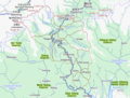 Upper Siang district with Tuting circle and Tuting

See also
[edit]| Leadership | |||||||||||||||||||||||||||||||||||||||||||||||||||||
|---|---|---|---|---|---|---|---|---|---|---|---|---|---|---|---|---|---|---|---|---|---|---|---|---|---|---|---|---|---|---|---|---|---|---|---|---|---|---|---|---|---|---|---|---|---|---|---|---|---|---|---|---|---|
| Components & commands |
| ||||||||||||||||||||||||||||||||||||||||||||||||||||
| Military academies |
| ||||||||||||||||||||||||||||||||||||||||||||||||||||
| Insignia | |||||||||||||||||||||||||||||||||||||||||||||||||||||
| History & future | |||||||||||||||||||||||||||||||||||||||||||||||||||||
| Other | |||||||||||||||||||||||||||||||||||||||||||||||||||||
References
[edit]- ^ Town. "Tuting". Times of India Travel. Retrieved 23 March 2019.
- ^ a b c d e "Place of interest | District Upper Siang, Government of Arunachal Pradesh". Retrieved 7 February 2021.
- ^ "Chinese road-building team entered 1km inside Arunachal, sent back by Indian Army: Sources". The Times of India. Retrieved 24 December 2018.
- ^ Dipak Kumar Dash. "Top officials to meet to expedite road building along China border". The Times of India. Retrieved 27 October 2014.
- ^ "Narendra Modi government to provide funds for restoration of damaged highways". Daily News and Analysis. Retrieved 27 October 2014.
- ^ Ankit Panda. "Indian Government Plans Highway Along Disputed China Border". thediplomat.com. Retrieved 27 October 2014.
- ^ "Govt planning road along McMohan line in Arunachal Pradesh: Kiren Rijiju". Mint. Retrieved 26 October 2014.
- ^ Ajay Banerjee. "China warns India against paving road in Arunachal". The Tribune. India. Retrieved 26 October 2014.
- ^ "Gelling". Government of Arunachal Pradesh. Retrieved 17 June 2021.
- ^ a b c "Districts Officials". Arunachal Pradesh, Official State Portal. Retrieved 23 March 2019.
- ^ "Subdivision & Blocks | District Upper Siang, Government of Arunachal Pradesh". Retrieved 23 March 2019.
Places adjacent to Tuting | ||||||||||||||||
|---|---|---|---|---|---|---|---|---|---|---|---|---|---|---|---|---|
| ||||||||||||||||
Tuting
View on GrokipediaGeography
Location and Topography
Tuting lies in the Upper Siang district of Arunachal Pradesh, northeastern India, at coordinates approximately 28°59′N 94°54′E.[6] The town is positioned along the banks of the Siang River, the upper course of the Brahmaputra, which originates from the Himalayas and flows southward through steep valleys in the region.[7] At an elevation of roughly 860 meters above sea level, Tuting occupies a site in the eastern Himalayan foothills, characterized by rugged terrain with steep gradients and narrow riverine gorges.[8] The surrounding landscape includes densely forested hills transitioning from subtropical broadleaf to coniferous zones at higher altitudes, contributing to high biodiversity in the area.[9] Proximate to the McMahon Line, the de facto boundary delineating the India-China frontier, Tuting sits about 34 kilometers south of the Line of Actual Control, in a strategically sensitive border zone marked by high mountain ridges and passes.[10] The Siang River and its tributaries have sculpted the local topography, forming alluvial plains prone to seasonal flooding from monsoon rains and glacial melt, which deposit sediments and influence erosion patterns across the valley floors.[11]Climate and Environment
Tuting exhibits a subtropical highland climate characterized by significant seasonal variations, with heavy monsoon rainfall exceeding 2,000 mm annually, primarily from June to September, driven by the region's orographic effects from the Himalayan foothills and proximity to the Tibetan Plateau. Winters from December to February are mild, with average temperatures ranging from 5°C to 15°C, while summers from May to August see highs of 20°C to 30°C, moderated by the town's elevation of approximately 1,240 meters.[12][13] The surrounding environment supports rich biodiversity, including endemic flora such as orchids and rhododendrons, alongside diverse fauna like rare butterflies (e.g., newly recorded species in Upper Siang), birds (e.g., Green Cochoa, Black-chinned Yuhina), and mammals in nearby areas like Mouling National Park. This ecological wealth stems from altitudinal gradients and forested valleys, positioning Upper Siang as a biodiversity hotspot in the Eastern Himalayas with high plant endemism.[14][15][16] Shifting cultivation, known locally as jhum, practiced by indigenous communities, contributes to deforestation and soil erosion, with Upper Siang districts experiencing a 75% rise in deforestation rates between 2017 and 2019 compared to prior baselines. Conservation efforts face challenges from proposed hydropower projects, such as the Siang Upper Multipurpose Project, which have sparked opposition over potential biodiversity loss and riverine ecosystem disruption, though proponents cite energy security needs.[17][18][19] The region lies in the seismically active Tidding-Tuting Suture Zone within the Eastern Himalayan Syntaxis, where tectonic convergence of the Indian and Eurasian plates generates frequent low- to moderate-magnitude earthquakes, increasing vulnerability to landslides exacerbated by steep topography and heavy rains. Historical events, including intensified seismic activity in 2017, have triggered widespread landslides along the Siang River, underscoring the area's high geohazard risk.[20][21]History
Pre-Colonial and Colonial Era
The Memba tribe, the primary indigenous inhabitants of Tuting and surrounding areas in Upper Siang, maintain oral traditions tracing their origins to migrations from Tibetan highland regions several centuries ago, establishing semi-nomadic settlements along the Siang River valley focused on pastoralism, shifting cultivation, and yak herding.[22] Adi subtribes, including Paadam groups, also settled in the vicinity, with folk histories recounting southward movements from northern origins, possibly Tibetan or Burmese borderlands, leading to territorial boundaries like the Sikut River separating Adi from Memba domains near Tuting Ngeying.[23] These communities operated largely autonomously, with economies centered on subsistence agriculture, hunting, and barter exchanges, including salt, wool, and medicinal herbs transported via established caravan routes connecting the Siang valley to Tibetan markets across passes like those near Gelling.[24] British colonial interest in the northeastern frontier emerged in the mid-19th century amid concerns over Russian and Chinese expansion, prompting exploratory expeditions into the Abor (Adi) hills, though Tuting's remote, high-altitude terrain limited penetration beyond forward posts. By the early 20th century, agreements with local tribes in 1912–1913 formalized the Inner Line policy, designating areas like Upper Siang as buffer zones with nominal oversight rather than direct administration.[25] The 1914 Simla Convention resulted in the McMahon Line demarcation, positioning Tuting firmly within British India's de facto territory by aligning the border along the Himalayan crest, though enforcement remained sporadic due to rugged access and tribal resistance to external authority.[26] Throughout the colonial period, Tuting's tribal societies retained self-sufficiency, with cross-border trade persisting informally despite British efforts to regulate frontier commerce and curb Tibetan influence, reflecting the limited infrastructural or governance imprint in such isolated locales until India's 1947 independence.[27]Post-Independence Developments
Following India's independence in 1947, the frontier tracts including Tuting fell under the North-East Frontier Agency (NEFA), with full administrative control established by 1954 to manage the region's tribal areas amid geopolitical sensitivities.[28] NEFA underwent reorganization, transitioning to the Union Territory of [Arunachal Pradesh](/page/Arunachal Pradesh) on January 20, 1972, and attaining statehood on February 20, 1987, which formalized Tuting's place within the expanding administrative framework of Upper Siang district, where it serves as headquarters of the Tuting circle.[29][1] The 1962 Sino-Indian War profoundly affected the area, as Chinese forces advanced along the Gelling-Tuting axis, reaching Tuting and occupying nearby positions, which revealed critical gaps in Indian forward defenses and infrastructure, leading to a unilateral Chinese withdrawal after initial gains.[30] This incursion, penetrating deep into NEFA territories, accelerated post-war efforts to fortify border outposts and improve logistical access, underscoring Tuting's frontline role in India's northeastern defenses.[30] Subsequent developments emphasized strategic infrastructure, with the Trans-Arunachal Highway (TAH), a 1,811 km route incorporating National Highway 13, extended post-2010s to link Tuting and Upper Siang, enhancing military mobility and civilian connectivity in response to ongoing border dynamics rather than solely economic drivers.[31] These initiatives, including road upgrades under the Border Roads Organisation, addressed the rugged terrain's challenges, with segments nearing completion by 2025 to integrate remote circles like Tuting into broader networks.[32]Administration and Demographics
Governance Structure
Tuting functions as the administrative headquarters of Tuting Circle and sub-division within Upper Siang district, Arunachal Pradesh, operating under the district's overarching framework headed by the Deputy Commissioner in Yingkiong.[33] The sub-division is led by an Additional Deputy Commissioner (ADC), assisted by a Circle Officer responsible for coordinating developmental activities, law and order, and implementation of central and state policies in the border region.[33] This structure ensures alignment with Indian federalism, where district-level coordination integrates local inputs for infrastructure and welfare initiatives. At the grassroots level, governance relies on Gram Panchayats, which manage village affairs including resource allocation and community welfare under the Arunachal Pradesh Panchayat Raj Act.[34] Examples include the Old Tuting-Purung-Ongkong Gram Panchayat, which oversees multiple villages and facilitates schemes such as rural employment generation and housing programs, though implementation faces challenges due to remote terrain and limited connectivity.[35] Electorally, Tuting forms part of the Tuting-Yingkiong Assembly constituency (No. 34) in the Arunachal Pradesh Legislative Assembly, with the broader district falling under the Arunachal East Lok Sabha constituency.[36] In the April 2024 state elections, Bharatiya Janata Party candidate Alo Libang won the seat, securing 6,095 votes (53.76% of total polled), reflecting active participation in a region where voter turnout supports representation of tribal interests at state and national levels.[37] Tribal customary institutions, including village councils dominated by Memba and Khamba communities, play an advisory role in decision-making, complementing formal administration by preserving traditional laws on land and dispute resolution, though without the autonomous powers granted under the Sixth Schedule of the Indian Constitution. Arunachal Pradesh, including Upper Siang, operates under state-specific mechanisms for tribal welfare rather than Sixth Schedule provisions, despite ongoing demands for inclusion to bolster local self-governance.[38]Population and Ethnic Composition
The population of Tuting circle in Upper Siang district stood at 5,207 as per the 2011 Indian census, entirely rural with no urban component, reflecting the remote, high-altitude terrain that limits settlement density to approximately 5 persons per square kilometer across the broader district.[39][40] Sex ratio in the district hovered at 888-891 females per 1,000 males, indicative of patterns common in Arunachal Pradesh's tribal areas where male out-migration for labor occasionally skews figures, though Tuting's isolation curtails such outflows.[1] Literacy rates in Upper Siang registered at 59.94% overall, with male literacy at around 66% and female at 53%, falling below the state average of 65.38% due to geographic barriers to schooling and reliance on subsistence activities over formal education.[41][42] Ethnically, Tuting's inhabitants are overwhelmingly indigenous Scheduled Tribes, comprising over 80% of the district's populace, with dominant groups including sub-tribes of the Adi (such as Padam and Minyong, speakers of Tani languages within the Tibeto-Burman family), Memba (practicing yak herding and following Tibetan-influenced Buddhism), and smaller pockets of Idu Mishmi, whose dialects reflect migratory ties to Tibetan and Burmese linguistic stocks.[43] Adi groups form the numerical core in the Siang valley extensions, while Memba presence intensifies near Tuting's border proximity to Bhutan and Tibet, fostering a mosaic of pastoral and swidden agricultural practices; Idu Mishmi contributions add hunting-foraging elements in peripheral hilly zones.[43] Linguistic diversity persists with Adi dialects predominant alongside Memba and Mishmi variants, showing limited penetration of Hindi or English owing to low literacy and endogamous community structures.[44] Migration remains minimal and seasonal, primarily involving Memba herders traversing high pastures for yak grazing, with scant permanent influx from India's plains due to restricted access under Inner Line Permit regulations and the predominance of indigenous land tenure systems that preserve tribal majorities against external settlement claims.[43] This insularity underscores Tuting's demographic stability, where population growth tracks Arunachal's decadal rate of about 22% from 2001-2011, though precise post-2011 projections for the circle are unavailable amid delayed census updates.[45]Economy
Primary Sectors
Agriculture remains the dominant primary sector in Tuting, a circle within Upper Siang district, where jhum (shifting) cultivation predominates as the primary method of farming among the Adi tribal population. This practice involves clearing forest patches for temporary fields, cultivating crops such as millet, rice (paddy), maize, and vegetables without synthetic fertilizers or pesticides, reflecting organic traditions.[1] Jhum fields support multiple cropping systems, enhancing biodiversity and nutrient diversity, though yields are constrained by the 5-10 year fallow cycles required for soil regeneration.[46] It engages the majority of the local workforce, consistent with state-level data showing agriculture and allied activities absorbing over 60% of rural employment in Arunachal Pradesh, with district-specific reliance even higher due to limited alternatives.[47] Forestry contributes supplementary income through extraction of timber, non-timber forest products, and medicinal plants, integral to the district's economy amid dense subtropical and temperate forests. Livestock rearing complements agriculture, focusing on indigenous breeds like mithun (Bos frontalis) for cultural and economic value, alongside yaks in higher altitudes and smaller animals for subsistence. These activities yield limited marketable surplus, with trade confined to local barter or rudimentary markets. Hydropower holds untapped potential along the Siyom River, which traverses Tuting's vicinity, with proposals like the Siang Upper and Siyom projects aiming to harness the basin's flow for generation capacities exceeding 1,000 MW each. However, exploitation remains minimal as of 2023, hampered by ecological risks including deforestation, biodiversity loss, soil erosion, landslides, and seismic vulnerabilities in this earthquake-prone Himalayan zone, alongside community opposition to displacement.[48][49] Overall, primary sectors in Tuting underscore underdevelopment, with Upper Siang district contributing only 2.69% to Arunachal Pradesh's gross state domestic product in 2021-22, far below state averages driven by services and construction elsewhere, reflecting subsistence-level outputs and infrastructural isolation. Per capita net district domestic product lags behind the state's ₹190,212 figure for 2022-23, exacerbating poverty despite resource abundance.[50]Infrastructure and Development Initiatives
The Government of India has implemented the Vibrant Villages Programme (VVP) in Tuting to foster infrastructure growth and economic resilience in this border area, with initiatives emphasizing sustainable facilities to reduce outmigration and support livelihoods. Launched in 2022, the programme has driven upgrades in Tuting, including enhancements to community infrastructure, as part of broader efforts to integrate remote villages into national development frameworks motivated by strategic border stabilization needs.[4] In April 2024, the Indian Army executed infrastructure projects under Operation Sadbhavana in Tuting, focusing on essential upgrades such as Anganwadi centers and veterinary facilities to bolster local self-sufficiency, with these efforts yielding measurable improvements in service delivery amid security-driven priorities.[51][52] District-level inspections in September 2025 by the Upper Siang Deputy Commissioner further assessed ongoing development works, identifying gaps in facilities while noting progress tied to central funding allocations.[53][54] Hydropower development represents a core initiative, with the proposed Upper Siang Multipurpose Storage Project (USMSP) targeting 11,000 MW capacity on the Siang River to generate power and regulate flows, primarily as a counter to China's upstream Medog dam, which poses flood risks. In September 2025, the central government and Arunachal Pradesh signed an MoU for a Siang region development package, providing pre-investment funding exceeding ₹10,000 crore for surveys and preparatory works, though progress has been slowed by environmental impact assessments and local opposition over potential submersion of over 25 villages.[55][56][57] These delays highlight tensions between ecological safeguards and geopolitical imperatives, as the project's reservoir of approximately 9 billion cubic meters is deemed essential for water security.[58] To address youth unemployment and skill gaps, state-level programs have been extended to Upper Siang, including vocational training under schemes like Kaushal Vikas Yojana, which provided on-the-job placements to over 1,000 trainees statewide by mid-2025, indirectly benefiting Tuting through defense-linked employment opportunities from VVP and military projects.[59] Per capita income in Arunachal Pradesh's border districts remains below the national average at around ₹1,50,000 annually as of 2023-24, but VVP-related jobs have contributed to incremental gains, estimated at 5-10% yearly in similar remote areas via infrastructure-linked hiring.[60] These efforts prioritize causal drivers like enhanced employability over migration, though quantifiable district-specific data remains limited due to sparse tracking.[61]Culture
Indigenous Communities
The indigenous communities of Tuting primarily comprise the Memba and Adi tribes, both exhibiting clan-based social organizations rooted in patrilineal descent and exogamous marriage practices within clans.[62][63] Among the Memba, who trace origins to Tibetan-Burman groups, society emphasizes patriarchal authority, patrilocality, and tribal endogamy, with clans serving as core units for identity and resource allocation in the high-altitude terrain.[62] The Adi, a dominant group in Upper Siang, similarly structure families patrilineally, with extended households centered on male lineage heads who oversee inheritance and land use.[63][64] Daily life revolves around cooperative labor and customary governance, with gender roles delineating responsibilities in subsistence activities. Adi women predominantly manage weaving, bamboo crafting for household items like baskets and mats, and supplemental agricultural tasks such as millet cultivation and foraging, while men handle hunting, heavier field clearing, and external trade.[63] Memba households follow parallel divisions, with women contributing to yak herding support and textile production integral to ritual attire, reflecting adaptations to the region's forested valleys.[22] Community decisions occur through assemblies like the Adi Kebang, a village council comprising adult males and select elders that adjudicates disputes, enforces norms, and allocates communal resources via consensus, embodying a pre-colonial democratic ethos resilient to external influences.[65][66] Memba equivalents draw on monastic oversight intertwined with lay councils for resolving intra-clan matters.[67] Religious beliefs shape social cohesion, with Memba communities adhering to the Nyingmapa school of Tibetan Buddhism, incorporating animistic elements in local rituals honoring mountain spirits alongside monastic vows.[67] Adi groups maintain Donyi-Polo, an indigenous faith venerating celestial bodies and ancestral spirits through shaman-led rites, though some clans show syncretic shifts toward Christianity or Hinduism amid modernization pressures.[64] Health and education face persistent hurdles due to Tuting's remote border location, exacerbating disparities for scheduled tribe populations. National Family Health Survey-5 data for Arunachal Pradesh indicate that among scheduled tribes, only 72.3% of children aged 6-17 attend school regularly, with dropout rates climbing above 20% in rural districts like Upper Siang owing to inadequate infrastructure, seasonal migration for labor, and limited teacher presence.[68] Malnutrition affects 28.5% of tribal children under five in the state, linked to food insecurity and sparse healthcare access, where primary health centers in areas like Tuting report immunization coverage below 60% for routine vaccines as of 2021.[68][69] These challenges persist despite targeted interventions, as geographic isolation hampers sustained service delivery.[70]Traditions and Festivals
The Adi tribe in Tuting observes the Solung festival annually in September-October, a harvest celebration tied to the completion of paddy transplantation and invoking agricultural prosperity through rituals, communal dances like Ponung, and the erection of the symbolic Yele Solung pole. These practices, rooted in animistic beliefs, include animal sacrifices and prayers to deities for protection against pests and favorable weather, reflecting the community's dependence on shifting cultivation cycles in the Siang valley.[5] The Memba community, adherents of Tibetan Vajrayana Buddhism, marks Losar—the Tibetan New Year—in February-March with monastery-centered observances featuring ritual prayers, butter lamp lightings, and feasts of traditional dishes like thukpa, emphasizing renewal and communal harmony amid the winter transition to spring.[71] This festival underscores the Memba migration from Tibet and their integration of Buddhist cosmology with local highland ecology, including offerings for livestock health before seasonal herding resumes.[5] Preserved traditions encompass oral epics recounting ancestral migrations and nature spirits, alongside artisanal crafts such as intricately woven cane helmets and bamboo implements used in rituals, which demonstrate adaptation to forested environments while resisting erosion from external influences like infrastructure development.[5] Military outposts introduce occasional syncretic elements, such as shared feasts during festivals, yet core practices remain intact, prioritizing tribal autonomy over assimilation.[5]Strategic Importance
Geopolitical Context
Tuting occupies a strategically sensitive position in Upper Siang district, Arunachal Pradesh, situated approximately 34 kilometers south of the Line of Actual Control (LAC) and astride the McMahon Line, which India upholds as the de jure border with China pursuant to the 1914 Simla Convention between British India and Tibet. China rejects the convention's legitimacy, viewing the McMahon Line as an invalid colonial imposition and claiming Tuting and surrounding areas as integral to "South Tibet" (Zangnan), historically linked to the Tibetan plateau under Qing Dynasty suzerainty, a narrative India counters with evidence of Tibetan autonomy and post-1914 administrative continuity south of the line.[72][73][74] The 1962 Sino-Indian War crystallized these competing claims, as Chinese forces advanced across the McMahon Line into Arunachal Pradesh, including sectors near Tuting, before withdrawing unilaterally to pre-war positions in November 1962, an action India interprets as tacit acknowledgment of its territorial integrity while China frames it as a temporary measure amid logistical constraints. This outcome, coupled with India's establishment of the North-East Frontier Agency (NEFA) in 1954 to formalize administration over frontier tracts, underscores empirical sovereignty through sustained governance, census enumerations, and electoral processes predating statehood in 1987.[75] Underlying the dispute are resource imperatives, with Tuting's proximity to the Siang River—a major Brahmaputra tributary—offering vast hydropower potential estimated at over 10,000 MW in the Upper Siang basin alone, alongside untapped mineral reserves like dolomite and graphite prevalent in Arunachal Pradesh, fueling external contestation beyond historical assertions. Border ambiguities trace to uneven colonial demarcation, yet India's infrastructure investments, such as road networks linking Tuting to Pasighat since the 1960s, concretize de facto control against narratives of undivided Tibetan heritage propagated by Beijing.[76][77]Border Tensions and Indian Response
Following the 1962 Sino-Indian War, which saw Chinese forces briefly occupy parts of Arunachal Pradesh including areas near Tuting, periodic incursions by People's Liberation Army (PLA) patrols have persisted along the Line of Actual Control (LAC) in Upper Siang district.[78] In December 2017, a Chinese road construction team advanced approximately 1 kilometer into Indian territory near Bishing village in the Tuting sector, deploying machinery before retreating after Indian forces seized equipment; China subsequently agreed to halt the activity during bilateral talks.[78] [79] Similar probes occurred in nearby Tuting and Asaphila areas during 2017-2018, amid broader PLA efforts resembling "salami-slicing" tactics—gradual territorial encroachments rejected by India as violations of established patrol norms.[80] Into the 2020s, PLA patrols near Tuting and Upper Siang have raised risks of Galwan Valley-style clashes, with India reporting around 300 annual transgressions across the eastern LAC, though specific Tuting incidents remain limited post-2018 disengagement.[81] Chinese assertions over Tuting, framed as part of "Zangnan" or South Tibet, rely primarily on post-1950s claims tied to Tibet's incorporation, rejecting the 1914 McMahon Line without pre-existing effective control or mutual recognition beyond suzerainty debates; these lack robust historical documentation predating modern boundary disputes.[72] Indian officials and analyses attribute such actions to aggressive expansionism rather than legitimate reclamation, emphasizing causal deterrence through enhanced presence over provocation.[82] India's countermeasures include forward deployments by the Indian Army and Indo-Tibetan Border Police in Upper Siang, bolstering deterrence against advances.[83] The Border Roads Organisation (BRO) has prioritized connectivity upgrades in Arunachal, enabling rapid troop mobility and reducing vulnerability to salami-slicing, with projects like strategic highway enhancements serving as empirical counters to China's infrastructure buildup rather than escalatory moves.[84] In August 2025, the Indian Army conducted outreach in Tuting, engaging local youth and educators to underscore operational readiness and successes in border management, reflecting integrated civil-military efforts to sustain local support amid tensions.[85] These steps have contributed to smoother patrols in some sectors and de-escalations, validating infrastructure's role in stabilizing the LAC.[81]Tourism
Natural and Cultural Attractions
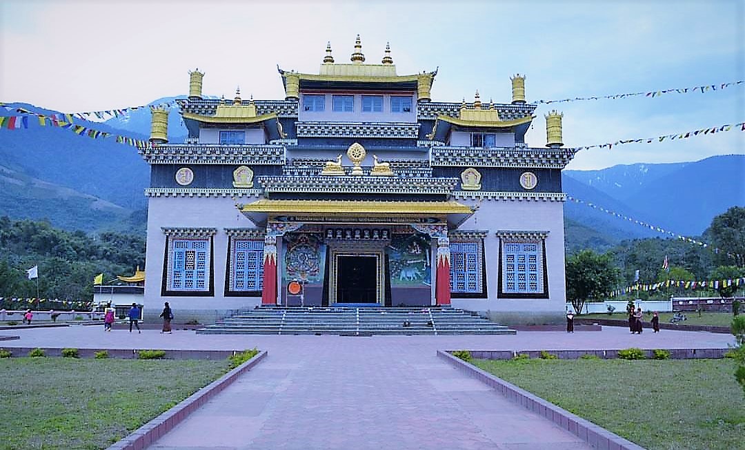
Tuting's natural landscape centers on the Siang River, a major tributary of the Brahmaputra, where the town lies along its banks amid Himalayan foothills and dense subtropical forests. The river features gorges and rapids suitable for advanced rafting expeditions, with stretches of intense whitewater extending from Tuting southward.[86][87] Surrounding mountains rise sharply, supporting diverse flora and fauna, including opportunities for wildlife observation in nearby habitats. Trekking routes, such as the multi-day path from Tuting to Singha, traverse the Pemako region, revealing varied ecosystems from riverine valleys to forested ridges.[88] Culturally, Tuting forms part of the Gelling-Tuting-Singa triangle, recognized as the Pemako Zone in Tibetan Buddhist tradition, characterized by scattered lama hamlets and monasteries integrated into the terrain. Sites like the Pema Moni Monastery house traditional artifacts and golden Buddha statues, reflecting the area's spiritual heritage influenced by cross-border Tibetan practices. Local Adi tribal communities maintain villages with vernacular architecture, including elevated longhouses, and periodic markets displaying woven textiles and bamboo crafts, though access remains restricted and visitor numbers are low due to the town's border proximity and underdeveloped infrastructure.[5][89] The pristine, low-impact environment appeals to eco-conscious trekkers seeking solitude, contrasted by basic amenities limited to rudimentary lodging and guides.[90]