
Community hub
Recent from talks
Contribute something
Nothing was collected or created yet.
Waitomo
View on Wikipedia
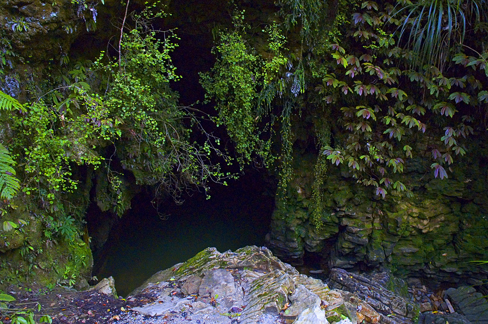
Waitomo, officially Waitomo Caves,[4] is a rural community in the King Country region of New Zealand's North Island. There are several solutional cave systems in the area around the village, which are popular tourist attractions. Restaurants and accommodation are centred in the village to serve visiting tourists.
Key Information


The word Waitomo comes from the Māori language: wai meaning water and tomo meaning a doline or sinkhole; it can thus be translated to be "water passing through a hole".[5] The caves are formed in Oligocene limestone.[6]
The historic Waitomo Caves Hotel is located in Waitomo Caves village.[7]
History
[edit]Māori lived in the Waitomo Caves area in the eighteenth and nineteenth centuries. Opapaka Pā to the east of the village was occupied by Ngāti Hia in the 1700s.[8] One of the first two explorers of the Waitomo Glowworm Cave in 1887 was Tane Tinorau, who lived nearby and knew the entrance to the cave as a good spot for catching eels.[9] Naturalist William Smith described seeing an abandoned Māori village or 'kāinga' of raupō huts across the valley near a lake, while he was travelling between the accommodation at Waitomo Caves and the Ruakuri Cave in 1906.[10]
The village of Waitomo Caves is named for the hundreds of caves present in the spectacular karst landscape. The limestone landscape of the Waitomo District area has been the centre of increasingly popular commercial caving tourism since before 1900, initially mostly consisting of impromptu trips guided by local Māori. The Waitomo Glowworm Cave near Waitomo Caves was nationalised by the Crown[11] and managed as a tourism attraction from 1904 onwards.[12] At this time tourists would set out for the Waitomo Glowworm Cave from Otorohanga or Hangatiki railway stations which had been opened in the 1880s. A 1915 guide said, "[The cave] is reached by railway to Hangatiki, thence 6 miles by coach along a good road".[13] There was tourist accommodation at Hangatiki in the early 1900s,[14] and by 1904 accommodation and a store had been built at Waitomo Caves.[15][16] In 1909 the government built a hotel, and the village gradually developed to support increasing tourism to the caves in the area.
The Waitomo Caves Museum provides information about the karst landscape, caves and caving and the history of the area.
Caves
[edit]
There are many caves in the Waitomo Caves area, but some are on private land or only accessible to cavers rather than tourists.[17] One example is Gardner's Gut at the Ruakuri Scenic Reserve. This is the largest cave system in the North Island, and it is used by caving clubs for beginner caving experience.
Companies specialise in leading tourists through some of the limestone caves of the area, which are noted for their stalactite and stalagmite displays and for the presence of glowworms (the fungus gnat Arachnocampa luminosa) in caves with streams running through them. Cave tours range from easily accessible areas with hundreds of tourists per hour in the peak season, to activities such as blackwater rafting and crawls into cave systems, which are only seen by a few tourists each day.[18] Tourist caves include:
- Waitomo Glowworm Cave: first explored in 1887, and famous for its Glowworm Grotto, where tourists glide through the dark on a boat under a canopy of glowworms.
- Ruakuri Cave: opened to the public from 1904 until 1988, when it was closed due to a legal and financial dispute. It reopened in 2005.[19] Ruakuri Cave is accessed via a spiral ramp and is wheelchair-accessible.[9] It also has glowworms. Blackwater rafting, abseiling and other adventure activities also take place in Ruakuri Cave.[9]
- Aranui Cave: found by accident in 1910 when Te Ruruku Aranui was out hunting and his dog fell down a hole.[9][20] Aranui Cave has no stream through it and no glowworms, but it is notable for its delicate stalactites and stalagmites in many colours.
- Mangawhitikau Cave and Spirit Cave (Te Ana o te Atua): a few kilometres south of Waitomo Caves. Both caves were opened to tourists in 1994, but access to Spirit Cave was temporarily lost around 1999 when the land it was on was sold. After negotiations and installation of lighting and paths, Spirit Cave reopened to the public in 2006.[21] Mangawhitikau Cave is noted for its glowworms, while the Spirit Cave has interesting speleothems and fossil moa bones.[22] Spirit Cave was visited in 1849 by military surgeon Arthur Thomson, who wrote a report about the cave and its moa bones in 1854 for the Edinburgh Philosophical Journal.[21][23]
- Piripiri Cave: a publicly accessible cave that is free to visit, 29 km west of Waitomo Caves in a Department of Conservation Scenic Reserve.[24]
In 2004, around 400,000 visitors entered caves in the area,[12] and a visit to Waitomo Caves made number 14 on a list of 101 "Kiwi must-do's" in a New Zealand Automobile Association poll of over 20,000 motorists published in 2007.[25]
Walks
[edit]The Waitomo Walkway runs through the valley of the Waitomo Stream (a tributary of the Waipā River) for 3.3 km (2.1 mi) from the village to the Ruakuri Scenic Reserve.[26] At the reserve the Ruakuri Walk leads through short caves to the Ruakuri Natural Bridge.[27] The Opapaka Pā walk to the east of the village was a short track through native forest and up to the site of a former pā, but it closed due to a large slip.[8]
The Mangapohue Natural Bridge is located 26 km to the west of Waitomo Caves. A short track lets visitors explore the area around the double arch, a remnant of a cave system that has disintegrated.[9][24]
Te Araroa, a national long distance walkway, passes through Waitomo. The section from Mt Pirongia joins the Waitomo Walkway to enter the village.[28] The 17.5 km (10.9 mi) section to Te Kūiti goes over Mangapu River suspension bridge and through Pehitawa kahikatea forest.[29]
Demographics
[edit]Hangatiki statistical area, which includes the settlement of Waitomo, covers 326.46 km2 (126.05 sq mi).[30] It had an estimated population of 1,390 as of June 2024,[31] with a population density of 4.3 people per km2.
| Year | Pop. | ±% p.a. |
|---|---|---|
| 2006 | 1,059 | — |
| 2013 | 1,101 | +0.56% |
| 2018 | 1,185 | +1.48% |
| 2023 | 1,254 | +1.14% |
| Source: [32][33] | ||
Hangatiki had a population of 1,254 in the 2023 New Zealand census, an increase of 69 people (5.8%) since the 2018 census, and an increase of 153 people (13.9%) since the 2013 census. There were 642 males, 609 females, and 3 people of other genders in 477 dwellings.[34] 2.4% of people identified as LGBTIQ+. The median age was 44.4 years (compared with 38.1 years nationally). There were 204 people (16.3%) aged under 15 years, 237 (18.9%) aged 15 to 29, 573 (45.7%) aged 30 to 64, and 240 (19.1%) aged 65 or older.[32]
People could identify as more than one ethnicity. The results were 73.7% European (Pākehā); 37.8% Māori; 1.4% Pasifika; 2.6% Asian; 0.7% Middle Eastern, Latin American and African New Zealanders (MELAA); and 3.8% other, which includes people giving their ethnicity as "New Zealander". English was spoken by 96.9%, Māori by 10.3%, Samoan by 0.2%, and other languages by 4.3%. No language could be spoken by 1.9% (e.g. too young to talk). New Zealand Sign Language was known by 0.5%. The percentage of people born overseas was 11.7, compared with 28.8% nationally.[32]
Religious affiliations were 28.5% Christian, 0.2% Islam, 3.6% Māori religious beliefs, 0.5% New Age, and 0.5% other religions. People who answered that they had no religion were 59.6%, and 6.9% of people did not answer the census question.[32]
Of those at least 15 years old, 174 (16.6%) people had a bachelor's or higher degree, 603 (57.4%) had a post-high school certificate or diploma, and 285 (27.1%) people exclusively held high school qualifications. The median income was $39,900, compared with $41,500 nationally. 81 people (7.7%) earned over $100,000 compared to 12.1% nationally. The employment status of those at least 15 was 558 (53.1%) full-time, 144 (13.7%) part-time, and 21 (2.0%) unemployed.[32]
Marae
[edit]The community has a number of marae, affiliated with Ngāti Maniapoto hapū:[35][36]
- Kaputuhi Marae is affiliated with the hapū of Ngāti Matakore, Pare te Kawa, Ngāti Peehi and Rōrā.
- Te Kauae Marae and Te Kauae o Niu Tereni meeting house are affiliated with the hapū of Huiao, Ngāti Kinohaku, Ngāti Peehi and Ngāti Te Kanawa.
- Te Korapatu Marae is affiliated with the hapū of Peehi and Te Kanawa.
- Pohatuiri Marae is affiliated with the hapū of Uekaha.
- Tokikapu Marae and Matua a Iwi meeting house are affiliated with the hapū of Ruapuha, Te Kanawa and Uekaha.[37]
Education
[edit]Waitomo Caves School is a co-educational state primary school,[38][39] with a roll of 31 as of July 2025.[40][41] It opened in 1910.[42]
See also
[edit]References
[edit]- ^ "2025 Triennial Elections Declaration of Result" (PDF). Electionz. Retrieved 22 October 2025.
- ^ "Taranaki-King Country - Official Result". Electoral Commission. Retrieved 8 March 2025.
- ^ "Hauraki-Waikato – Official Result". New Zealand Electoral Commission. Retrieved 27 February 2025.
- ^ "Place name detail: Waitomo Caves". New Zealand Gazetteer. Land Information New Zealand. Retrieved 23 June 2025.
- ^ "Waitomo Caves". Encyclopedia of New Zealand (1966).
- ^ "The Geological History of New Zealand". Archived from the original on 19 September 2016. Retrieved 16 May 2014.
- ^ "Search the List | Waitomo Hotel | Heritage New Zealand". www.heritage.org.nz. Retrieved 4 August 2021.
- ^ a b "Opapaka Pā Walk". www.doc.govt.nz. Retrieved 3 July 2025.
- ^ a b c d e Bain, Brydie Walker (2013). New Zealand's Waitomo Caves: Time, water, light. Waitomo Caves, New Zealand: A Great Backyard. ISBN 9780473227746.
- ^ Smith, W. W. (27 September 1912). "Ruakura and Waitomo Caves". Taranaki Herald.
- ^ Evans, Kate (May–June 2017). "Rock Stars". New Zealand Geographic.
The Scenery Preservation Act of 1903 gave the government far-reaching powers to forcibly purchase land, and in 1904 the Waitomo Glowworm Cave was the first place to be nationalised. The landowners were awarded £625 in compensation
- ^ a b Caving tourism (from Te Ara: The Encyclopedia of New Zealand)
- ^ Bradbury, E E (1915). The Raglan and Kawhia Districts. Waikato University library: Bradbury. p. 85.
- ^ "Local and general news". New Zealand Herald. 14 July 1905.
- ^ "In the King Country". Waikato Times. 25 July 1904.
- ^ "Local and general". Waikato Times.
[...] there is an excellent accommodation house, quite near the caves, kept by Mrs de Bourbel.
- ^ Hobson, Daphne. "Waitomo Caves". [New Zealand Speleological Bulletin] (100): 585–602.
- ^ "Waitomo Caves Tours". Trip Advisor. Retrieved 5 May 2025.
- ^ "Prime Minister to re-open spectacular Ruakuri Cave" (Press release). 26 July 2005.
- ^ "Aranui Cave". King Country Chronicle. 11 February 1911.
- ^ a b Chandler, Peter; Chandler, Libby (October 2012). "Spellbound Glowworm and Cave Tours" (PDF). ACKMA Journal (88): 8–11.
- ^ "Spellbound Glowworm Cave". Spellbound Glowworm Cave Tours. Retrieved 3 July 2025.
- ^ Thomson, Arthur S. (1854). "Description of two caves in the North Island of New Zealand, in which were found bones of the large extinct wingless bird, called by the Natives, Moa,and by Naturalists, Diornis; with some general observations on this genus of birds.". The Edinburgh New Philosophical Journal. Edinburgh, Scotland: A. and C. Black. pp. 272–275.
- ^ a b Public caves of New Zealand: A guide to New Zealand's publicly-accessible caves (PDF). Waitomo Caves, New Zealand: New Zealand Speleological Society. November 2023. pp. 13–15. ISSN 2357-2213.
- ^ Dye, Stuart (10 February 2007). "Peaks, sounds, parks and islands tops in Kiwi eyes". The New Zealand Herald. Retrieved 1 December 2011.
- ^ "Waitomo Walkway". www.doc.govt.nz. Department of Conservation. Retrieved 4 February 2017.
- ^ "Ruakuri Walk". www.doc.govt.nz. Department of Conservation. Retrieved 4 February 2017.
- ^ "Pirongia to Waitomo:Te Araroa – New Zealand's Trail – Waikato / King Country". www.teararoa.org.nz. Archived from the original on 23 January 2020. Retrieved 4 February 2017.
- ^ "Pehitawa Track:Te Araroa – New Zealand's Trail – Waikato / King Country". www.teararoa.org.nz. Archived from the original on 23 January 2020. Retrieved 4 February 2017.
- ^ "Stats NZ Geographic Data Service". Statistical Area 2 2023 (generalised). Retrieved 5 May 2025.
- ^ "Aotearoa Data Explorer". Statistics New Zealand. Retrieved 26 October 2024.
- ^ a b c d e "Totals by topic for individuals, (RC, TALB, UR, SA3, SA2, Ward, Health), 2013, 2018, and 2023 Censuses". Stats NZ – Tatauranga Aotearoa – Aotearoa Data Explorer. Hangatiki (187100). Retrieved 3 October 2024.
- ^ "Statistical area 1 dataset for 2018 Census". Statistics New Zealand. March 2020. Hangatiki (187100). 2018 Census place summary: Hangatiki
- ^ "Totals by topic for dwellings, (RC, TALB, UR, SA3, SA2, Ward, Health), 2013, 2018, and 2023 Censuses". Stats NZ – Tatauranga Aotearoa – Aotearoa Data Explorer. Retrieved 3 October 2024.
- ^ "Te Kāhui Māngai directory". tkm.govt.nz. Te Puni Kōkiri.
- ^ "Māori Maps". maorimaps.com. Te Potiki National Trust.
- ^ "Tainui Maniapoto - Hapū and Marae". Te Puni Kōkiri. Archived from the original on 21 January 2020. Retrieved 9 December 2019.
- ^ "Waitomo Caves School Official School Website". waitomocaves.school.nz.
- ^ "Waitomo Caves School Ministry of Education School Profile". educationcounts.govt.nz. Ministry of Education.
- ^ "New Zealand Schools Directory". New Zealand Ministry of Education. Retrieved 1 July 2025.
- ^ "Waitomo Caves School Education Review Office Report". ero.govt.nz. Education Review Office.
- ^ Waitomo Caves School (1960). "Waitomo Caves schools golden jubilee: history of Waitomo Caves School and district, 1910-1960".
External links
[edit]- Waitomo Caves area in Episode 4 "Caves" of BBC's Planet Earth.
- Waitomo Caves Museum & Discovery Centre
Waitomo
View on GrokipediaGeography
Location and Landscape
Waitomo District is a predominantly rural territorial authority in the Waikato region of New Zealand's North Island, within the King Country area. It lies approximately 80 km south of Hamilton and 200 km south of Auckland, with its administrative center at Te Kuiti. The district covers 3,546 km², bordered by the Tasman Sea to the west and neighboring districts including Ōtorohanga, Taupō, Ruapehu, and New Plymouth.[3] The landscape is dominated by karst terrain, primarily formed from Oligocene-age limestone deposits of the Te Kuiti Group, which cover extensive areas around Te Kuiti and Waitomo.[5] This karst features solutional cave systems developed through prolonged water dissolution and erosion over millions of years, creating underground networks and surface features like sinkholes and streams.[6] The Waitomo Stream, a key waterway in the area, flows as a tributary of the Waipā River, contributing to the region's hydrological dynamics.[7]Climate and Environment
Waitomo District experiences a temperate maritime climate characteristic of New Zealand's North Island, influenced by westerly winds and proximity to the Tasman Sea.[8] Annual rainfall averages 1,473 mm, with the highest precipitation occurring during the winter months of May and June, while summer months see the lowest levels. Temperatures are mild, with average summer temperatures of 18.5°C and winter averages of 9.5°C, accompanied by moderate humidity levels and occasional frost in cooler periods.[3] The region's natural environment supports diverse native flora and fauna, particularly within its podocarp-broadleaf forests that dominate the surrounding hills and valleys. These forests feature prominent podocarp species such as rimu (Dacrydium cupressinum) and kahikatea (Dacrycarpus dacrydioides), alongside broadleaf trees, understorey ferns, and mosses adapted to the damp conditions.[9] Cave ecosystems host unique bioluminescent species, including the glowworm Arachnocampa luminosa, which thrives in the dark, humid subterranean habitats and plays a key role in controlling insect populations by luring prey with its light.[10] Environmental conservation in Waitomo is actively managed by the Department of Conservation (DOC) to protect these sensitive karst landscapes and ecosystems from tourism-related pressures. Efforts focus on monitoring and mitigating impacts such as condensation corrosion in cave formations, caused by human-induced humidity changes, through visitor limits, ventilation controls, and partnerships with local operators to ensure sustainable access.[11][12]History
Māori Settlement and Early Exploration
The Waitomo region forms part of the traditional territory of Ngāti Maniapoto, a Tainui iwi whose ancestors arrived in Aotearoa New Zealand aboard the Tainui waka around 1300 AD, with migrations extending inland along river valleys such as the Waipā to establish settlements in the area by the 17th century.[13] The ancestor Maniapoto himself is linked to the limestone caves of Waitomo, where he resided in his later years, underscoring the iwi's deep historical ties to the landscape as part of broader Tainui migration routes from coastal landing sites like Kāwhia.[14] These routes facilitated travel, trade, and resource use across the Waikato-Waitomo area long before European contact.[15] The name "Waitomo" derives from te reo Māori terms "wai," meaning water, and "tomo," referring to a hole or shaft, evoking the distinctive feature of rivers vanishing into subterranean passages through the region's karst formations.[2] For Māori, the caves held profound practical and spiritual value, serving as temporary shelters during journeys and sources of resources like birds, fish, and native plants used for food and medicine.[16][17] Spiritually, many were designated wahi tapu—sacred sites employed for burials and adorned with pictographs—infused with legends of taniwha as protective guardians of underground realms, or tales of discovery, such as the young hunter whose dog fell into what became known as Ruakuri Cave, meaning "den of dogs."[18] These sites were approached with reverence, rarely entered without purpose, reflecting a holistic cultural connection to the natural environment unbound by commercialization.[16] In 1887, the Glowworm Caves received their first documented exploration when Ngāti Maniapoto chief Tāne Tinorau and English surveyor Fred Mace ventured into the system on a flax raft illuminated by candles, uncovering the ethereal display of bioluminescent glowworms along the ceiling.[19][20] This expedition, building on longstanding Māori knowledge of the caves' entrances, provided the earliest recorded access to their inner depths.European Arrival and Tourism Development
European exploration of the Waitomo region intensified in the late 19th century through surveys conducted by government officials, which facilitated land acquisitions and the formal mapping of its cave systems. The 1887 expedition by English surveyor Fred Mace and local Māori chief Tāne Tinorau marked a pivotal shift from indigenous knowledge to colonial documentation, leading to increased interest in the area's natural formations and subsequent land surveys that supported European settlement and resource assessment in the King Country region.[19] Following the 1887 exploration, the Waitomo Glowworm Caves were opened to the public in 1889 by Tāne Tinorau and his wife Huti, who guided early tourists through the site for a modest fee, sparking initial tourism growth. Visitor numbers rose steadily, prompting government intervention to protect the caves from overuse; in 1906, under the Scenery Preservation Act of 1903, the administration of the caves was nationalized by the New Zealand government, marking one of its first such acquisitions to ensure preservation and controlled access. In 1989, the cave and surrounding land were returned to the descendants of Tāne Tinorau and Huti, who entered into a lease arrangement with the government for ongoing management and tourism operations.[19][21][22][19] To accommodate the influx of visitors, the Waitomo Caves Hotel was constructed in 1908 by the Tourist and Health Resorts Department, providing essential lodging and establishing Waitomo as a formalized tourist destination.[19][21][22] Infrastructure developments in the 20th century further propelled tourism. In the 1920s, the road to Waitomo Caves was metalled, improving accessibility and reducing travel times from nearby towns, which encouraged more domestic visitors. The post-World War II era saw a significant tourism boom in New Zealand, driven by international air travel advancements and the country's rising global profile, with Waitomo benefiting from this surge as one of the nation's premier natural attractions. By the 1980s, innovative experiences like black-water rafting were introduced in 1987 by the Legendary Black Water Rafting Company, offering underground tubing adventures that diversified offerings and attracted adventure seekers. These milestones solidified Waitomo's status in international tourism.[23][24][25]Tourism and Attractions
Caves and Underground Features
The Waitomo region is renowned for its extensive karst landscape, which includes over 300 known caves formed through the dissolution of limestone by acidic groundwater over millions of years. These subterranean systems showcase a variety of speleothems, underground rivers, and unique bioluminescent ecosystems, drawing visitors for guided explorations that highlight their geological and biological significance.[26][27] The Waitomo Glowworm Caves represent the most iconic of these systems, consisting of a 400-meter-long network accessible via an underground river that allows for boat tours drifting beneath ceilings illuminated by thousands of glowworms. Stalactites and stalagmites adorn the chambers, formed by mineral-rich dripstone over millennia, creating cathedral-like spaces that enhance the ethereal atmosphere produced by the bioluminescent display.[28][29][30] Ruakuri Cave extends over 14 kilometers of passages, featuring dramatic vertical shafts, waterfalls, and dense colonies of glowworms that create shimmering constellations along the walls and ceilings. Visitors enter via a striking spiral staircase that descends 17 meters into the cave, avoiding traditional tapu-restricted openings while providing access to illuminated walkways and glowworm habitats. The cave was first opened to the public in 1904 but was closed in 1988 due to legal and financial disputes. It was redeveloped and reopened for modern guided tours in 2005.[18][31][32] In contrast, Aranui Cave offers a drier exploration without glowworms or water features, emphasizing intricate limestone formations such as flowing flowstone sheets, delicate helictites that twist in multiple directions, and towering stalagmites in chambers like the Cathedral. Its stable paths and lack of extreme drops make it accessible for those seeking a gentler subterranean experience focused on the artistic diversity of speleothems in pale brown, pink, and white hues.[33][34][35] Geologically, the caves of Waitomo formed within the Te Kuiti Group's Oligocene limestone (approximately 23–34 million years old), deposited in a shallow marine environment rich in calcium carbonate from ancient seabeds, with dissolution processes accelerating during the Miocene epoch as sea levels fluctuated. This limestone preserves marine fossils such as bryozoans and mollusks, visible in cave walls, while some sites contain archaeological evidence of early Māori use, including tools and burial remnants discovered during explorations in the 19th century.[27][29][36] Central to the caves' allure are the glowworms, scientifically known as Arachnocampa luminosa, carnivorous larvae of fungus gnats that inhabit damp, dark ceilings. Their lifecycle begins with eggs hatching into larvae that spin silk traps dangling with sticky threads to capture prey like midges, sustaining growth over 6–9 months before pupation into short-lived adults that do not feed. The blue-green bioluminescence, used to lure prey, results from an oxidation reaction involving a unique luciferin molecule—comprising tyrosine and xanthurenic acid residues—catalyzed by a firefly-like luciferase enzyme in an ATP-dependent process.[37][38][39]Walks and Outdoor Activities
The Waitomo Walkway is a popular 3.3 km trail that meanders through a classic limestone landscape, native bush, and open farmland alongside the Waitomo Stream, offering scenic river views and gentle terrain suitable for all ages and fitness levels.[40] Maintained by the Department of Conservation (DOC), the track is graded easy to intermediate, with an estimated one-way duration of 1 hour 15 minutes, though some sections include short steep parts; it starts opposite the Waitomo Discovery Centre and connects to broader networks like the Te Araroa Trail.[41] Sections of the Te Araroa National Walkway, New Zealand's 3,000 km trail from Cape Reinga to Bluff, pass through the Waitomo area as part of the Waikato region route, providing opportunities for multi-day hikes amid diverse terrain.[42] The Pirongia to Waitomo segment spans approximately 45 km, traversing farmland, an airstrip, old logging routes, and lush native forest, with features like stream crossings and elevated views; hikers should prepare for steep tracks and potential wet conditions in low-lying areas.[42] These longer routes link Waitomo to other North Island trails, such as the onward path to Pureora Forest Park, emphasizing self-sufficient tramping with DOC-managed signage and sustainable low-impact practices.[42][43] Adventure activities in Waitomo cater to thrill-seekers with options like blackwater rafting on the Ruakuri Cave river, which was introduced in 1987 by the Legendary Black Water Rafting Company to provide an exhilarating underground river experience.[44] Complementing this are abseiling and ziplining opportunities, including the Waitomo Caves Zipline Park's 1 km canopy tour featuring ten lines through native forest, with the longest reaching 280 m at speeds up to 80 km/h, designed for participants aged 7 and older under guided supervision.[45] These activities promote sustainable tourism through regulated group sizes and environmental guidelines to minimize impact on the surrounding limestone and bush ecosystems.[46] Mountain biking enthusiasts can explore the Timber Trail, an 85 km two-day route following historic logging paths with suspension bridges and flowing singletrack, suitable for intermediate riders and managed for low environmental disturbance.[47] Shorter options include the 35 km Waitomo District Mountain Bike Challenge, winding through native bush and limestone country on a mix of gravel and technical tracks.[48] Fishing in the Waitomo River and nearby Marokopa River offers productive spots for rainbow and brown trout, with about 3 km of accessible water below falls ideal for spin or fly fishing, regulated by Fish & Game to ensure sustainable catches through seasonal limits and habitat protection.[49]Community and Culture
Demographics
The Waitomo District had a usually resident population of 9,585 according to the 2023 New Zealand Census.[50] This represents a 3.0% increase from 9,303 residents recorded in the 2018 Census, reflecting slight annual growth of approximately 0.6% over the intercensal period.[50] The estimated resident population for the district reached approximately 9,950 as of 2025, with projections indicating continued modest growth of around 0.5% annually.[51] The population density remains low at about 2.7 people per square kilometre across the 3,546 km² area, characteristic of its rural setting.[50] Ethnic composition in Waitomo District is diverse, with multiple ethnic identifications permitted in the census. The breakdown from the 2023 Census is as follows:| Ethnic Group | Percentage | Number of People |
|---|---|---|
| European | 62.6% | 6,002 |
| Māori | 45.3% | 4,341 |
| Pacific Peoples | 4.4% | 422 |
| Asian | 5.0% | 479 |
| Middle Eastern/Latin American/African | 0.4% | 38 |
| Other (including New Zealander) | 1.3% | 125 |