
Community hub
Recent from talks
Contribute something to knowledge base
Content stats: 0 posts, 0 articles, 1 media, 0 notes
Members stats: 0 subscribers, 0 contributors, 0 moderators, 0 supporters
Subscribers
Supporters
Contributors
Moderators
Hub AI
Pyrenees AI simulator
(@Pyrenees_simulator)
Hub AI
Pyrenees AI simulator
(@Pyrenees_simulator)
Pyrenees
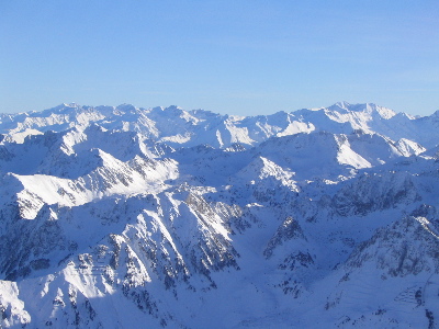
The Pyrenees are a mountain range straddling the border of France and Spain. They extend nearly 500 km (310 mi) from their union with the Cantabrian Mountains to Cap de Creus on the Mediterranean coast, reaching a maximum elevation of 3,404 metres (11,168 ft) at the peak of Aneto.
For the most part, the main crest forms a political divide between the states of Spain and France, with the microstate of Andorra sandwiched in between. Historically, the Crown of Aragon and the Kingdom of Navarre extended on both sides of the mountain range.
In Greek mythology, Pyrene is a princess who gave her name to the Pyrenees. The Greek historian Herodotus says Pyrene is the name of a town in Celtic Europe. According to Silius Italicus, she was the virgin daughter of Bebryx, a king in Mediterranean Gaul by whom the hero Hercules was given hospitality during his quest to steal the cattle of Geryon during his famous Labours. Hercules, characteristically drunk and lustful, violates the sacred code of hospitality and rapes his host's daughter. Pyrene gives birth to a serpent and runs away to the woods, afraid that her father will be angry. Alone, she pours out her story to the trees, attracting the attention of wild beasts who tear her to pieces.
After his victory over Geryon, Hercules passes through the kingdom of Bebryx again, finding the girl's lacerated remains. As is often the case in stories of this hero, the sober Hercules responds with heartbroken grief and remorse at the actions of his darker self, and lays Pyrene to rest tenderly, demanding that the surrounding geography join in mourning and preserve her name: "struck by Herculean voice, the mountaintops shudder at the ridges; he kept crying out with a sorrowful noise 'Pyrene!' and all the rock-cliffs and wild-beast haunts echo back 'Pyrene!' ... The mountains hold on to the wept-over name through the ages." Pliny the Elder connects the story of Hercules and Pyrene to Lusitania, but rejects it as fabulosa, highly fictional.
Other classical sources derived the name from the Greek word for fire, Ancient Greek: πῦρ (IPA: /pŷːr/). According to Greek historian Diodorus Siculus "in ancient times, we are told, certain herdsmen left a fire and the whole area of the mountains was entirely consumed; and due to this fire, since it raged continuously day after day, the surface of the earth was also burned and the mountains, because of what had taken place, were called the Pyrenees."
The Spanish Pyrenees are part of the following provinces, from east to west: Girona, Barcelona, Lleida (all in Catalonia), Huesca (in Aragon), Navarra (in Navarre) and Gipuzkoa (in the Basque Country).
The French Pyrenees are part of the following départements, from east to west: Pyrénées-Orientales (also known as Northern Catalonia), Aude, Ariège, Haute-Garonne, Hautes-Pyrénées, and Pyrénées-Atlantiques (the latter two of which include the Pyrenees National Park).
The independent principality of Andorra is sandwiched in the eastern portion of the mountain range between the Spanish Pyrenees and French Pyrenees.
Pyrenees
The Pyrenees are a mountain range straddling the border of France and Spain. They extend nearly 500 km (310 mi) from their union with the Cantabrian Mountains to Cap de Creus on the Mediterranean coast, reaching a maximum elevation of 3,404 metres (11,168 ft) at the peak of Aneto.
For the most part, the main crest forms a political divide between the states of Spain and France, with the microstate of Andorra sandwiched in between. Historically, the Crown of Aragon and the Kingdom of Navarre extended on both sides of the mountain range.
In Greek mythology, Pyrene is a princess who gave her name to the Pyrenees. The Greek historian Herodotus says Pyrene is the name of a town in Celtic Europe. According to Silius Italicus, she was the virgin daughter of Bebryx, a king in Mediterranean Gaul by whom the hero Hercules was given hospitality during his quest to steal the cattle of Geryon during his famous Labours. Hercules, characteristically drunk and lustful, violates the sacred code of hospitality and rapes his host's daughter. Pyrene gives birth to a serpent and runs away to the woods, afraid that her father will be angry. Alone, she pours out her story to the trees, attracting the attention of wild beasts who tear her to pieces.
After his victory over Geryon, Hercules passes through the kingdom of Bebryx again, finding the girl's lacerated remains. As is often the case in stories of this hero, the sober Hercules responds with heartbroken grief and remorse at the actions of his darker self, and lays Pyrene to rest tenderly, demanding that the surrounding geography join in mourning and preserve her name: "struck by Herculean voice, the mountaintops shudder at the ridges; he kept crying out with a sorrowful noise 'Pyrene!' and all the rock-cliffs and wild-beast haunts echo back 'Pyrene!' ... The mountains hold on to the wept-over name through the ages." Pliny the Elder connects the story of Hercules and Pyrene to Lusitania, but rejects it as fabulosa, highly fictional.
Other classical sources derived the name from the Greek word for fire, Ancient Greek: πῦρ (IPA: /pŷːr/). According to Greek historian Diodorus Siculus "in ancient times, we are told, certain herdsmen left a fire and the whole area of the mountains was entirely consumed; and due to this fire, since it raged continuously day after day, the surface of the earth was also burned and the mountains, because of what had taken place, were called the Pyrenees."
The Spanish Pyrenees are part of the following provinces, from east to west: Girona, Barcelona, Lleida (all in Catalonia), Huesca (in Aragon), Navarra (in Navarre) and Gipuzkoa (in the Basque Country).
The French Pyrenees are part of the following départements, from east to west: Pyrénées-Orientales (also known as Northern Catalonia), Aude, Ariège, Haute-Garonne, Hautes-Pyrénées, and Pyrénées-Atlantiques (the latter two of which include the Pyrenees National Park).
The independent principality of Andorra is sandwiched in the eastern portion of the mountain range between the Spanish Pyrenees and French Pyrenees.
Recent media
Recent media