Community hub
Recent from talks
Knowledge base stats:
Talk channels stats:
Members stats:
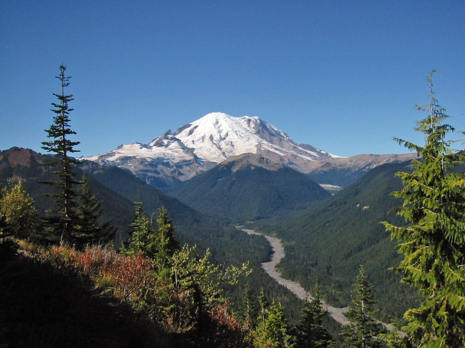
Cascade Volcanoes
The Cascade Volcanoes (also known as the Cascade Volcanic Arc or the Cascade Arc) are a number of volcanoes in a continental volcanic arc in western North America, extending from southwestern British Columbia through Washington and Oregon to Northern California, a distance of well over 700 miles (1,100 km). The arc formed due to subduction along the Cascadia subduction zone. Although taking its name from the Cascade Range, this term is a geologic grouping rather than a geographic one, and the Cascade Volcanoes extend north into the Coast Mountains, past the Fraser River which is the northward limit of the Cascade Range proper.
Some of the major cities along the length of the arc include Portland, Seattle, and Vancouver, and the population in the region exceeds 10 million. All could be potentially affected by volcanic activity and great subduction-zone earthquakes along the arc. Because the population of the Pacific Northwest is rapidly increasing, the Cascade volcanoes are some of the most dangerous, due to their eruptive history and potential for future eruptions, and because they are underlain by weak, hydrothermally altered volcanic rocks that are susceptible to failure. Consequently, Mount Rainier is one of the Decade Volcanoes identified by the International Association of Volcanology and Chemistry of the Earth's Interior (IAVCEI) as being worthy of particular study, due to the danger it poses to Seattle and Tacoma. Many large, long-runout landslides originating on Cascade Volcanoes have engulfed valleys tens of kilometers from their sources, and some of the areas affected now support large populations.
The Cascade Volcanoes are part of the Pacific Ring of Fire, the ring of volcanoes and associated mountains around the Pacific Ocean. The Cascade Volcanoes have erupted several times in recorded history. Two most recent were Lassen Peak in 1914 to 1921 and a major eruption of Mount St. Helens in 1980. It is also the site of Canada's most recent major eruption, in 410 BCE at the Mount Meager massif.
The Cascade Arc includes nearly 20 major volcanoes, among a total of over 4,000 separate volcanic vents including numerous stratovolcanoes, shield volcanoes, lava domes, and cinder cones, along with a few isolated examples of rarer volcanic forms such as tuyas. Volcanism in the arc began about 37 million years ago; however, most of the present-day Cascade Volcanoes are less than 2,000,000 years old, and the highest peaks are less than 100,000 years old. Twelve volcanoes in the arc are over 10,000 feet (3,000 m) in elevation, and the two highest, Mount Rainier and Mount Shasta, exceed 14,000 feet (4,300 m). By volume, the two largest Cascade Volcanoes are the broad shields of Medicine Lake Volcano and Newberry Volcano, which are about 145 and 108 cu mi (600 and 450 km3) respectively. Glacier Peak is the only Cascade Volcano that is made exclusively of dacite. The history of the Cascade Volcanoes can be separated into three major chapters which are discussed below.
The time between 37 million and 17 million years ago is known as the West Cascades period, this era is characterized as being when the volcanoes in this region were exceptionally active. During this time the arc was situated a little farther west than it is today. One volcano that was active during this time was the Mount Aix Volcanic Complex, which erupted more than 100 km3 (24 cu mi) of tephra and pyroclastic debris over the span of just three eruptions. Lavas representing the earliest stage in the development of the Cascade Volcanic Arc mostly crop out south of the North Cascades proper, where uplift of the Cascade Range has been less, and a thicker blanket of Cascade Arc volcanic rocks has been preserved. In the North Cascades, geologists have not yet identified with any certainty any volcanic rocks as old as 35 million years, but remnants of the ancient arc's internal plumbing system persist in the form of plutons, which are the crystallized magma chambers that once fed the early Cascade volcanoes. The greatest mass of exposed Cascade Arc plumbing is the Chilliwack batholith, which makes up much of the northern part of North Cascades National Park and adjacent parts of British Columbia beyond. Individual plutons range in age from about 35 million years old to 2.5 million years old. The older rocks invaded by all this magma were affected by the heat. Around the plutons of the batholith, the older rocks recrystallized. This contact metamorphism produced a fine mesh of interlocking crystals in the old rocks, generally strengthening them and making them more resistant to erosion. Where the recrystallization was intense, the rocks took on a new appearance dark, dense and hard. Many rugged peaks in the North Cascades owe their prominence to this baking. The rocks holding up many such North Cascade giants, as Mount Shuksan, Mount Redoubt, Mount Challenger, and Mount Hozomeen, are all partly recrystallized by plutons of the nearby and underlying Chilliwack batholith.
The West Cascades period came to an end 17 million years ago when the Columbia River flood basalts began erupting in eastern Washington and Oregon. For a reason unknown to scientists the initiation of the flood basalts seemingly caused a significant dip in volcanic activity in the cascade chain lasting for over 8 million years. During this time the volcanoes were stripped down to their cores by weathering and erosion because they were not active enough to rebuild. This low point lasted from 17 to 9 million years ago and came to end when the Columbia flood basalts waned.
As production of the Columbia River flood basalts slowed 9 million years ago the Cascade volcanoes became active again. The volcanic arc also drifted farther east to its present location. When the Columbia basalts stopped entirely 6 million years ago the Cascades of central Oregon spectacularly flared up. This flare up lasted between 6.25 and 5.45 million years ago and is known as the Deschutes Formation. During this 800,000 year span approximately 400 to 675 km3 (96 to 162 cu mi) of pyroclastic material was expelled in 78 distinct eruptions. It has been hypothesized that a heightened flux of basalt, possibly induced by tectonic slab-rollback, was focused beneath the volcanic arc and into the shallow crust by minor amounts of crustal extension. This extension allowed for the high flux of basalt to be stored at shallow levels beneath a new arc locus within fertile crust, resulting in the silica-rich volcanism we see in the Deschutes Formation. After this pulse of activity the cascades retreated to the levels of activity we are more familiar with today.
For the remaining 5 or so million years the ancestors of many of the modern day Cascade volcanoes were built. Around half a million years ago a generation of older volcanoes died and many of the stratovolcanoes that we see today began their growth such as Glacier Peak and Mt. Shasta (600,000 years ago), Mt. Rainier and Mt. Hood (500,000 years ago), Mt. Adams (450,000 years ago), and Mt. Mazama (420,000 years ago).
Hub AI
Cascade Volcanoes AI simulator
(@Cascade Volcanoes_simulator)
Cascade Volcanoes
The Cascade Volcanoes (also known as the Cascade Volcanic Arc or the Cascade Arc) are a number of volcanoes in a continental volcanic arc in western North America, extending from southwestern British Columbia through Washington and Oregon to Northern California, a distance of well over 700 miles (1,100 km). The arc formed due to subduction along the Cascadia subduction zone. Although taking its name from the Cascade Range, this term is a geologic grouping rather than a geographic one, and the Cascade Volcanoes extend north into the Coast Mountains, past the Fraser River which is the northward limit of the Cascade Range proper.
Some of the major cities along the length of the arc include Portland, Seattle, and Vancouver, and the population in the region exceeds 10 million. All could be potentially affected by volcanic activity and great subduction-zone earthquakes along the arc. Because the population of the Pacific Northwest is rapidly increasing, the Cascade volcanoes are some of the most dangerous, due to their eruptive history and potential for future eruptions, and because they are underlain by weak, hydrothermally altered volcanic rocks that are susceptible to failure. Consequently, Mount Rainier is one of the Decade Volcanoes identified by the International Association of Volcanology and Chemistry of the Earth's Interior (IAVCEI) as being worthy of particular study, due to the danger it poses to Seattle and Tacoma. Many large, long-runout landslides originating on Cascade Volcanoes have engulfed valleys tens of kilometers from their sources, and some of the areas affected now support large populations.
The Cascade Volcanoes are part of the Pacific Ring of Fire, the ring of volcanoes and associated mountains around the Pacific Ocean. The Cascade Volcanoes have erupted several times in recorded history. Two most recent were Lassen Peak in 1914 to 1921 and a major eruption of Mount St. Helens in 1980. It is also the site of Canada's most recent major eruption, in 410 BCE at the Mount Meager massif.
The Cascade Arc includes nearly 20 major volcanoes, among a total of over 4,000 separate volcanic vents including numerous stratovolcanoes, shield volcanoes, lava domes, and cinder cones, along with a few isolated examples of rarer volcanic forms such as tuyas. Volcanism in the arc began about 37 million years ago; however, most of the present-day Cascade Volcanoes are less than 2,000,000 years old, and the highest peaks are less than 100,000 years old. Twelve volcanoes in the arc are over 10,000 feet (3,000 m) in elevation, and the two highest, Mount Rainier and Mount Shasta, exceed 14,000 feet (4,300 m). By volume, the two largest Cascade Volcanoes are the broad shields of Medicine Lake Volcano and Newberry Volcano, which are about 145 and 108 cu mi (600 and 450 km3) respectively. Glacier Peak is the only Cascade Volcano that is made exclusively of dacite. The history of the Cascade Volcanoes can be separated into three major chapters which are discussed below.
The time between 37 million and 17 million years ago is known as the West Cascades period, this era is characterized as being when the volcanoes in this region were exceptionally active. During this time the arc was situated a little farther west than it is today. One volcano that was active during this time was the Mount Aix Volcanic Complex, which erupted more than 100 km3 (24 cu mi) of tephra and pyroclastic debris over the span of just three eruptions. Lavas representing the earliest stage in the development of the Cascade Volcanic Arc mostly crop out south of the North Cascades proper, where uplift of the Cascade Range has been less, and a thicker blanket of Cascade Arc volcanic rocks has been preserved. In the North Cascades, geologists have not yet identified with any certainty any volcanic rocks as old as 35 million years, but remnants of the ancient arc's internal plumbing system persist in the form of plutons, which are the crystallized magma chambers that once fed the early Cascade volcanoes. The greatest mass of exposed Cascade Arc plumbing is the Chilliwack batholith, which makes up much of the northern part of North Cascades National Park and adjacent parts of British Columbia beyond. Individual plutons range in age from about 35 million years old to 2.5 million years old. The older rocks invaded by all this magma were affected by the heat. Around the plutons of the batholith, the older rocks recrystallized. This contact metamorphism produced a fine mesh of interlocking crystals in the old rocks, generally strengthening them and making them more resistant to erosion. Where the recrystallization was intense, the rocks took on a new appearance dark, dense and hard. Many rugged peaks in the North Cascades owe their prominence to this baking. The rocks holding up many such North Cascade giants, as Mount Shuksan, Mount Redoubt, Mount Challenger, and Mount Hozomeen, are all partly recrystallized by plutons of the nearby and underlying Chilliwack batholith.
The West Cascades period came to an end 17 million years ago when the Columbia River flood basalts began erupting in eastern Washington and Oregon. For a reason unknown to scientists the initiation of the flood basalts seemingly caused a significant dip in volcanic activity in the cascade chain lasting for over 8 million years. During this time the volcanoes were stripped down to their cores by weathering and erosion because they were not active enough to rebuild. This low point lasted from 17 to 9 million years ago and came to end when the Columbia flood basalts waned.
As production of the Columbia River flood basalts slowed 9 million years ago the Cascade volcanoes became active again. The volcanic arc also drifted farther east to its present location. When the Columbia basalts stopped entirely 6 million years ago the Cascades of central Oregon spectacularly flared up. This flare up lasted between 6.25 and 5.45 million years ago and is known as the Deschutes Formation. During this 800,000 year span approximately 400 to 675 km3 (96 to 162 cu mi) of pyroclastic material was expelled in 78 distinct eruptions. It has been hypothesized that a heightened flux of basalt, possibly induced by tectonic slab-rollback, was focused beneath the volcanic arc and into the shallow crust by minor amounts of crustal extension. This extension allowed for the high flux of basalt to be stored at shallow levels beneath a new arc locus within fertile crust, resulting in the silica-rich volcanism we see in the Deschutes Formation. After this pulse of activity the cascades retreated to the levels of activity we are more familiar with today.
For the remaining 5 or so million years the ancestors of many of the modern day Cascade volcanoes were built. Around half a million years ago a generation of older volcanoes died and many of the stratovolcanoes that we see today began their growth such as Glacier Peak and Mt. Shasta (600,000 years ago), Mt. Rainier and Mt. Hood (500,000 years ago), Mt. Adams (450,000 years ago), and Mt. Mazama (420,000 years ago).