Hubbry Logo
Coromandel, New ZealandCoromandel, New ZealandMain
Open search
Coromandel, New Zealand
Community hub
Coromandel, New Zealand
logo
8 pages, 0 posts
0 subscribers
Be the first to start a discussion here.
Coromandel, New Zealand
from Wikipedia

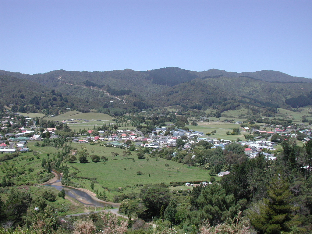
Coromandel, (Māori: Kapanga) also called Coromandel Town to distinguish it from the wider district, is a town on the Coromandel Harbour, on the western side of the Coromandel Peninsula, which is in the North Island of New Zealand.[6] It is 75 kilometres east of the city of Auckland, although the road between them, which winds around the Firth of Thames and Hauraki Gulf coasts, is 190 km long. The population was 1,780 as of June 2025[5].

Key Information

The town was named after HMS Coromandel, which sailed into the harbour in 1820.[7] At one time Coromandel Harbour was a major port serving the region's gold mining and kauri industries. Today, the town's main industries are tourism and mussel farming.

Coromandel Harbour is a wide bay on the Hauraki Gulf guarded by several islands, the largest of which is Whanganui Island. The town and environs are a popular summer holiday destination for New Zealanders. Coromandel Town is noted for its artists, crafts, alternative lifestylers, mussel farming, and recreational fishing. One of the most popular tourist attractions is the Driving Creek Railway.

Demographics

[edit]

Coromandel covers 10.89 km2 (4.20 sq mi)[4] and had an estimated population of 1,780 as of June 2025,[8] with a population density of 163 people per km2.

Historical population
YearPop.±% p.a.
20061,494—    
20131,518+0.23%
20181,743+2.80%
20231,782+0.44%
Source: [9][10]
1883 painting of the Coromandel Harbour by Philip Walsh

Coromandel had a population of 1,782 in the 2023 New Zealand census, an increase of 39 people (2.2%) since the 2018 census, and an increase of 264 people (17.4%) since the 2013 census. There were 873 males, 903 females and 3 people of other genders in 771 dwellings.[11] 3.0% of people identified as LGBTIQ+. The median age was 56.9 years (compared with 38.1 years nationally). There were 219 people (12.3%) aged under 15 years, 210 (11.8%) aged 15 to 29, 723 (40.6%) aged 30 to 64, and 630 (35.4%) aged 65 or older.[10]

People could identify as more than one ethnicity. The results were 85.5% European (Pākehā); 29.8% Māori; 2.4% Pasifika; 2.2% Asian; 0.2% Middle Eastern, Latin American and African New Zealanders (MELAA); and 2.0% other, which includes people giving their ethnicity as "New Zealander". English was spoken by 98.3%, Māori language by 7.7%, and other languages by 5.2%. No language could be spoken by 1.2% (e.g. too young to talk). New Zealand Sign Language was known by 0.7%. The percentage of people born overseas was 14.8, compared with 28.8% nationally.[10]

Religious affiliations were 21.5% Christian, 0.2% Hindu, 0.2% Islam, 2.4% Māori religious beliefs, 1.2% Buddhist, 0.7% New Age, and 1.9% other religions. People who answered that they had no religion were 65.3%, and 6.9% of people did not answer the census question.[10]

Of those at least 15 years old, 234 (15.0%) people had a bachelor's or higher degree, 846 (54.1%) had a post-high school certificate or diploma, and 480 (30.7%) people exclusively held high school qualifications. The median income was $28,300, compared with $41,500 nationally. 75 people (4.8%) earned over $100,000 compared to 12.1% nationally. The employment status of those at least 15 was that 534 (34.2%) people were employed full-time, 216 (13.8%) were part-time, and 51 (3.3%) were unemployed.[10]

Modern history

[edit]
The name "Coromandel Town" is written on the plan of Whanganui Island.

The original Government plan for the town of Coromandel was for it to be built on Whanganui Island. Plans were drawn up and sections were sold but the plan was unsuccessful, in part because the land was too steep and there was no suitable fresh water source. Most of the sections were abandoned and purchased by the Government. The town was then established where it is today.

Education

[edit]

Coromandel Area School (Te Kura a Rohe o Waiau) is a co-educational state composite (years 1–13) school[12] with a roll of 219 as of October 2025.[13] The school traces its history to the opening of Coromandel School in 1875.[14][15]

Coromandel Rudolf Steiner School was a small private full primary (years 1–8) school. It closed at the end of 2007.[16]

Marae

[edit]

The local Manaia Marae and Te Kou o Rehua meeting house, are a meeting ground for the Ngāti Pūkenga iwi, and its Ngāti Maru hapū.[17][18]

In October 2020, the Government committed $276,216 from the Provincial Growth Fund to upgrade the marae, creating an estimated 8 jobs.[19]

The Old Coromandel Hospital is a meeting place for Te Patukirikiri iwi.[17][18]

Panoramic view of the town from a lookout in the Kauri Block

Climate

[edit]
Climate data for Coromandel (1981–2010)
Month Jan Feb Mar Apr May Jun Jul Aug Sep Oct Nov Dec Year
Mean daily maximum °C (°F) 23.7
(74.7)
23.9
(75.0)
22.6
(72.7)
20.2
(68.4)
17.7
(63.9)
15.5
(59.9)
14.7
(58.5)
15.2
(59.4)
16.7
(62.1)
18.1
(64.6)
20.0
(68.0)
22.1
(71.8)
19.2
(66.6)
Daily mean °C (°F) 19.2
(66.6)
19.6
(67.3)
18.1
(64.6)
15.9
(60.6)
13.7
(56.7)
11.6
(52.9)
10.7
(51.3)
11.2
(52.2)
12.6
(54.7)
14.1
(57.4)
15.8
(60.4)
17.8
(64.0)
15.0
(59.1)
Mean daily minimum °C (°F) 14.7
(58.5)
15.3
(59.5)
13.6
(56.5)
11.6
(52.9)
9.8
(49.6)
7.7
(45.9)
6.6
(43.9)
7.3
(45.1)
8.6
(47.5)
10.1
(50.2)
11.6
(52.9)
13.5
(56.3)
10.9
(51.6)
Average rainfall mm (inches) 112.8
(4.44)
155.9
(6.14)
156.2
(6.15)
184.1
(7.25)
138.1
(5.44)
192.4
(7.57)
215.3
(8.48)
212.0
(8.35)
186.0
(7.32)
142.6
(5.61)
146.6
(5.77)
150.5
(5.93)
1,992.5
(78.45)
Source: NIWA[20]

References

[edit]
[edit]
Revisions and contributorsEdit on WikipediaRead on Wikipedia
from Grokipedia
Coromandel is a coastal town and rural community on the west coast of the in New Zealand's , serving as a key settlement in the Thames-Coromandel District. With a usually resident population of 1,782 at the 2023 census, it features a median age of 56.9 years and is home to a significant population of 531, primarily affiliated with iwi such as Te Patukirikiri. The town covers an area of approximately 10.89 square kilometres and is characterised by its historic charm, including preserved 19th-century buildings from era, making it a focal point for the peninsula's cultural and natural heritage. The , on which the town is located, is a rugged, 85-kilometre-long landform projecting northward into the from the western end of the , separating the to the west from the to the east. Its backbone, the Coromandel Range, rises to over 800 metres and is covered in native podocarp-broadleaf forests, with the peninsula's total area encompassing about 193,000 hectares of diverse terrain including beaches, hot springs, and geothermal features. The broader Thames-Coromandel District, which includes the town and much of the peninsula, had an estimated resident population of 33,700 as of June 2023. Historically, Coromandel was established following the arrival of in the 1830s, named after HMS Coromandel, which visited the harbour in 1820, and it experienced rapid growth during the 1852 discovery that triggered a short-lived rush, followed by from the 1860s. and kauri dominated the local economy in the late 19th and early 20th centuries, but these industries declined after 1900, leading to a shift toward farming and production, with a factory opening in 1911. The town revived in the 1960s, attracting retirees, artists, and alternative lifestylers due to its isolation, affordable housing, and scenic appeal, while modern has resumed at sites like Waihī since 1987. Today, is the cornerstone of Coromandel's , drawing visitors to attractions such as nearby Cathedral Cove, , and walking tracks through native forests, with the peninsula's population swelling up to six times during summer holidays. Other economic activities include agriculture in the Hauraki Plains to the south of the peninsula, fishing, and limited mining, supporting a that balances preservation of its natural environment—managed under conservation plans—with sustainable development. The area's rich history, dating back to Polynesian settlement around 1250–1300 CE by iwi like and , underscores its cultural significance, though land ownership now stands at only about 2% of the region.

Geography

Location and Topography

Coromandel is situated at coordinates 36°45′18″S 175°30′8″E on the of . The town lies on the western shore of Coromandel Harbour, a broad inlet of the , at the base of the . This positioning places it approximately 67 km east of by straight-line distance and about 170 km by road via State Highway 25, which winds through coastal and hilly terrain. The town's topography encompasses an area of 10.89 km² with a of 163 people per km², reflecting its compact urban footprint amid varied natural features. It is bordered by the Coromandel Range, a volcanic backbone that extends along the peninsula between the to the west and the to the east, characterized by steep hills rising to elevations over 800 m. The surrounding landscape includes coastal flats along the harbour, rugged inland hills, and remnants of ancient kauri forests, with nearby walks revealing waterfalls and mature podocarp-broadleaf stands. The region's environmental profile highlights a pristine coastal setting with sandy and boulder beaches, sheltered bays, and the sheltered waters of Coromandel Harbour, which support significant operations, particularly farming. The peninsula's volcanic contributes geothermal activity, evident in hot springs scattered across the area, such as those near to the southeast. Whanganui Island, a notable ecological reserve in the harbour, lies just offshore, enhancing the area's and scenic isolation.

Climate and Environment

Coromandel, New Zealand, experiences a temperate maritime climate with subtropical influences, particularly in its northern coastal areas, resulting in mild temperatures throughout the year without pronounced extremes. The average annual temperature stands at 15.2°C, accompanied by an annual rainfall of 1,255 mm, distributed relatively evenly but with higher in winter months. This supports lush and outdoor activities, though is notable in summer. Historical averages from 1981–2010 illustrate the region's consistency: , the warmest month, typically sees daytime highs of 19.6°C and nighttime lows of 13.5°C, while , the coolest, features highs of 15.1°C and lows of 8.2°C. Summers remain humid with occasional warm spells, and winters are damp but rarely frosty, influenced by the surrounding that moderates temperature fluctuations. The peninsula's exposure to rain-bearing northeasterly contributes to its reliable moisture, while coastal swells shape the dynamic shoreline environment. Ecologically, Coromandel boasts rich , including extensive native forests of kauri and podocarp-broadleaf types that harbor diverse birdlife, with ongoing conservation efforts focused on the endangered Coromandel brown kiwi, whose population has benefited from predator control and habitat restoration programs. The Te Whanganui-o-Hei (Cathedral Cove) Marine Reserve protects 840 hectares of coastal waters, safeguarding rocky reefs, forests, and species like snapper and from . However, human activities such as and exert pressures on water quality, with increased sediment and nutrient runoff from coastal development potentially leading to algal blooms, though farms also provide natural filtration benefits. As of 2025, there is growing emphasis on in Coromandel, driven by projections of rising sea levels—expected to increase by 0.3 to 1 meter by 2100—that threaten harbors like and Coromandel Town through inundation and , prompting local councils to invest in adaptive such as elevated seawalls and restoration. In early 2025, the Thames-Coromandel District Council advanced projects including enhanced coastal monitoring and community-led following 2024 weather events.

History

Māori and Early European Settlement

The Coromandel Peninsula served as a traditional homeland for several iwi, including Ngāti Maru, Ngāti Pūkenga, and Te Patukirikiri, who maintained deep connections to the land through ancestral ties and resource use. These groups utilized the region's abundant coastal and forested resources for sustenance, establishing pā sites on headlands and harbors for defense and community living, while engaging in fishing in the nutrient-rich waters of the and gathering shellfish, birds, and native plants from the surrounding bush. Coromandel Harbour held particular significance as a sheltered navigation point for waka, facilitating inter-iwi , , and migration along the peninsula's waterways since around 1250–1300 CE, when Polynesian voyagers likely made first landfalls in the area. European contact with the region began in the early , driven by demand for kauri timber suitable for ship masts and spars. In June 1820, the British naval vessel HMS Coromandel anchored in the harbor—then known to as Umangawha—to procure kauri logs, leading to the naming of the harbor, town, and peninsula after the ship. Early European traders, including whalers and timber merchants from , initiated small-scale kauri extraction around this time, with Driving Creek emerging as a vital site for log transport due to its steep terrain and watercourse, which allowed logs to be floated downstream to loading points. These activities marked the onset of commercial resource use, often involving bartering with local for access to timber stands. By the 1830s, initial European settlement took root, primarily centered on timber operations, with American trader William Webster establishing the first permanent base and at Te Tiki near Coromandel Harbour around 1836 to kauri for export. In 1839, the , under emerging colonial authority, formalized land acquisitions in the area, including Webster's purchase of the Te Kopu block from leaders such as Puakanga, as part of efforts to regulate pre-Treaty transactions amid growing settler interests. An early settlement attempt on Whanganui Island, purchased from Te Patukirikiri in 1836, aimed to create a timber outpost but faltered due to disputes over land validity and limited viability, resulting in retaining surplus acres after investigation and preventing full colonial establishment.

Gold Mining and Kauri Industries

The gold rush in the Coromandel region began with the first significant discovery in at Driving Creek near Coromandel Town in 1852, when sawmiller Charles Ring found traces of while working at a local mill. This initial find sparked a modest , drawing prospectors to the area despite limited alluvial deposits that yielded only small quantities, such as £4,000 worth by the end of 1862. Mining techniques soon shifted to more substantial reef operations by the late , following larger discoveries like the 1867 Thames field, which attracted investment from companies and led to peaks in production during the and . Over the century from 1852 to 1952, the broader Coromandel to Waihī area produced approximately £40 million worth of , establishing the region as a cornerstone of early colonial extraction. Parallel to gold, the kauri industry emerged in the , focusing on harvesting timber and gum from the dense forests of the , which were prized for and export. Coromandel Harbour served as a primary export port, with spars and logs shipped to markets in and America, fueling an industry that peaked alongside the gold boom in the late . To facilitate , over 200 dams were constructed in valleys such as Whangapoua, Tairua, and Kauaeranga to drive logs down rivers to the coast, while early railways, including one at Driving Creek built in the , transported timber and supported milling operations. These industries drove a rapid population influx, with the Thames goldfield alone reaching a peak of around 18,000 residents by mid-1868 amid the rush, swelling the regional total to over 10,000 in the and transforming remote areas into bustling settlements. However, they also caused significant , including river and from mining in catchments like the Ohinemuri and Waihou, as well as widespread that stripped mature kauri stands across hundreds of hectares. By the late 1800s, as alluvial fields and accessible timber resources were exhausted, both sectors declined, with output waning due to depleted reefs and kauri logging shifting to more remote areas before major operations ceased in the early 1920s.

Modern Developments

By the early , the gold mining and kauri industries that had defined Coromandel's growth had largely declined, prompting a shift to and small-scale farming. A opened in 1911 to process local produce, while the town's shallow harbor limited coastal shipping and exacerbated isolation until road access improved. These changes marked a period of economic stabilization, with the population stabilizing around farming communities. Tourism emerged as a vital sector in the mid-20th century, gaining momentum in the as enhanced road connections from Thames made the peninsula more accessible to visitors seeking its historic charm and natural beauty. Retirees, artists, and alternative lifestylers were drawn to affordable and the town's isolated, old-world appeal, laying the foundation for a holiday destination. In the 1970s, diversified the economy further, with farming beginning through a trial longline system anchored in Coromandel Harbour in 1978, capitalizing on the nutrient-rich waters to establish a industry. Entering the , Coromandel's cultural landscape evolved with the expansion of its arts community, featuring numerous galleries, studios, and events that highlight local craftsmanship and creativity, contributing to both resident identity and visitor appeal. The Driving Creek Railway, hand-built starting in the 1970s by potter Barry Brickell to access clay resources, was extended and opened to tourists in 1990, becoming a key attraction by the late through its narrow-gauge tracks winding through regenerating native bush. The 2020s brought challenges from the , but the region showed strong recovery, with tourism generating $370 million in visitor spending in 2023-24 through targeted resilience projects focused on and community support. In 2020, Manaia received $276,216 in provincial development funding for renovations to enhance cultural facilities. By 2025, sustainable initiatives continued, including the Coromandel Harbour Facilities Project, which advances feasibility studies and business cases for upgraded marine to support eco-friendly growth. Notable events included the closure of the Rudolf Steiner School in 2007, signaling adjustments in local amid broader demographic shifts.

Demographics

The population of Coromandel town experienced significant fluctuations tied to its . During the 1860s , the town's peaked at approximately 10,000 as prospectors flocked to the area following discoveries of alluvial gold. After the boom subsided in the late 19th century, the declined sharply to around 1,000 by 1900 due to exhausted claims and shifting economic opportunities. From the 1950s onward, the stabilized at between 1,500 and 1,800 residents, supported by a transition to more sustainable industries like , , and emerging , with figures showing 1,518 in 2013, 1,743 in 2018, and steady growth thereafter. As of the 2023 , Coromandel's usually resident population stood at 1,782, with an estimated resident population of 1,780 in 2025. The town encompasses 771 private dwellings and covers an area of 10.89 km², yielding a of 163 people per km². The median age of 56.9 years highlights the town's appeal to retirees, contributing to its older demographic profile compared to national averages. Looking ahead, medium-growth projections for the Thames-, which includes Coromandel town, anticipate gradual expansion driven by retirement migration and limited natural increase, reaching approximately 33,000 residents by 2033. For Coromandel town specifically, this suggests modest growth toward around 2,000 residents over the same period. Seasonally, the effective in the Thames-Coromandel District swells to over twice its usual size during peak summer periods, with Coromandel town experiencing around a 30-40% increase based on local utility data, as holidaymakers and tourists boost numbers through short-term accommodations and visits.

Ethnic and Social Composition

The ethnic composition of Coromandel reflects a predominantly European heritage with significant presence, as recorded in the . Of the usually resident population, 85.5% identified as European (), 29.8% as , 2.4% as Pacific Peoples, 2.2% as Asian, 0.2% as Middle Eastern/Latin American/African, and 1% as other ethnicities. Multiple ethnic identifications are permitted, resulting in totals exceeding 100%, which underscores the diverse ancestries within the community. Social indicators highlight an aging, stable with strong cultural ties. The age stands at 56.9 years, notably higher than the national of 38.1 years, contributing to a retiree-heavy demographic that shapes local lifestyles and services. Languages are overwhelmingly English, with 7.7% of the also speaking te reo , alongside smaller proportions speaking German (1.5%) or French (1.3%). Home ownership rates are elevated, exceeding 76% of households in the encompassing Thames-Coromandel , reflecting economic security among long-term residents. Community life integrates artistic expression and Māori heritage, fostering a vibrant social fabric. The area supports an arts-oriented lifestyle through initiatives like the Coromandel Arts and Creative Industries Strategy, which emphasizes toi alongside performing and . Māori residents maintain strong connections to local , including Ngāti Maru, Ngāti Whanaunga, and Ngāti Pūkenga, which influence cultural practices and community events.

Economy and Tourism

Primary Industries

Aquaculture forms the cornerstone of Coromandel's primary industries, particularly through green-lipped mussel () farming in Coromandel Harbour, which began in the early 1970s. This sector has grown into a major exporter, with Coromandel producing approximately 26% of 's total mussel output, supporting global markets through companies like Sanford that utilize longline technology in the region. Locally, it employs around 200 people in the Coromandel-Colville ward, contributing to direct economic activity valued at tens of millions annually within the broader Thames-Coromandel District. Sustainable practices are emphasized, with the industry adhering to frameworks like A+ New Zealand Sustainable and receiving high ratings from the Aquarium's program for environmental performance. Mining, primarily at nearby sites like Waihī, remains limited but contributes to the district's , with operations supporting regional and output as of 2023. Beyond , other primary activities remain limited in scale. is constrained by the region's topography, focusing on small orchards—such as and —and numerous lifestyle blocks used for hobby farming or semi-commercial production of fruits, , and . Remnant kauri gum digging persists on a small, non-commercial basis, with occasional discoveries of amber-like from ancient forests highlighting the area's historical resource ties, though regulated to protect ecosystems. activities are similarly residual, involving limited harvesting from native remnants and stands, contributing to the district's overall primary sector of about 880 jobs across , , and . These industries underpin the local , with primary sectors accounting for roughly 7% of the Thames-Coromandel District's filled jobs and supporting a GDP of approximately $1.7 billion for the year ending September 2023. represents a significant share of this output in Coromandel, driving about 17% of local in the ward and aligning with low of 3.4% district-wide in 2023, below the national average.

Key Attractions and Visitor Economy

The visitor economy forms a vital part of Coromandel town's economic fabric, drawing significant numbers of tourists to the peninsula and supporting local businesses centered on arts, crafts, and outdoor experiences. In the Thames-Coromandel District, which encompasses the town, tourism generated 840,700 guest nights in the year ending June 2025, with domestic visitors comprising 80.2% of total spending. Visitor spending peaked at $52.4 million in January 2025, underscoring the summer season's dominance when accommodations and services see heightened demand. The sector contributed $211.2 million to the district's GDP in 2024, accounting for 11.7% of overall economic output and highlighting its role in sustaining employment in hospitality and retail. Prominent attractions in Coromandel town emphasize its artistic heritage and natural surroundings. The Driving Creek Railway, a narrow-gauge bush railway rebuilt in the 1990s by potter and engineer Barry Brickell, offers eco-focused tours lasting 1 hour and 15 minutes through regenerating native forest, crossing viaducts and tunnels while promoting conservation. Complementing this are historic tours that explore the area's 19th-century rush era, providing educational walks and exhibits on extraction techniques and settler life. The town also hosts numerous art galleries and studios, exemplified by the annual Coromandel Arts Trail, a free self-guided tour over two weekends featuring over 30 local artists showcasing painting, sculpture, and crafts in their workspaces. Water-based activities include harbor expeditions and visits to mussel farms, where tours demonstrate sustainable amid scenic coastal views. Recent initiatives reflect a shift toward . In 2025, the announced plans to introduce entry fees of NZ$20 to $40 for foreign visitors at high-volume sites including nearby Cathedral Cove starting in 2027, aimed at raising up to $62 million annually for conservation efforts such as track maintenance and protection— residents remain exempt. Additionally, regenerative tourism programs in the prioritize environmental restoration, with Destination Hauraki Coromandel designating kiwi populations as a key performance indicator; initiatives like the Coromandel Kiwi Project protect habitat across 1,300 hectares above the town, fostering visitor involvement in predator control and native planting to boost bird numbers. These efforts align with ecological goals, ensuring long-term viability for attractions.

Community and Infrastructure

Education and Schools

The Coromandel Area , known in as Te Kura a o Waiau, serves as the primary educational institution for students from years 1 to 13 in the town and surrounding areas. Established in 1875 during the Coromandel gold rush to educate miners' children, it has evolved into a state composite emphasizing community ties and local heritage. As of August 2025, the has a roll of 209 students and holds an Equity Index of 510, reflecting its socioeconomic context within the Thames-Coromandel District. Facilities at the school include modern technology resources integrated into classrooms and multipurpose sports courts featuring synthetic turf for community and student use, supporting activities like , , and . The curriculum incorporates , drawing on the region's through programs such as Trees for Survival, where students plant native species to restore local streams and habitats. A smaller private option, the Coromandel Rudolf Steiner School, operated as a full primary (years 1–8) until its voluntary closure at the end of 2007 due to low enrollment and operational challenges. No dedicated tertiary institutions exist locally, but residents access programs from the , including distance learning options in , environmental sciences, and , often tailored for regional learners. Community education supplements formal schooling through workshops organized by groups like Creative Coromandel, offering classes in , , and felt-making at venues such as Driving Creek Railways, fostering creative skills tied to the peninsula's artistic heritage.

Marae and Cultural Sites

The Manaia , located south of Coromandel township, serves as a key cultural hub affiliated with Ngāti Pūkenga and Ngāti Maru , built on land gifted to Ngāti Pūkenga by Ngāti Maru in recognition of historical alliances. Its , Te Kou o Rehua, honors the of Ngāti Pūkenga and Te Tawera tribes during the , while the wharekai is named Ngairihanga, connecting the site to waka traditions, the Manaia River, and surrounding maunga. In October 2020, the marae received $276,216 in Provincial Growth Fund support for renovations aimed at enhancing its facilities for community gatherings. Te Patukirikiri Marae occupies the site of the former Old Coromandel Hospital on Rings , vested in Te Patukirikiri as part of their 2018 settlement to recognize cultural significance in the Kāpanga district. Currently without a dedicated , it functions as a versatile space for local , hosting hui, community events, and while supporting Te Patukirikiri's over the Coromandel area. These play central roles in community life in Coromandel, where approximately 30% of the population identifies as , serving as venues for , cultural education, and preservation of te reo Māori and tikanga. They foster intergenerational knowledge transmission through wānanga and integrate with the region's vibrant arts scene, including performances that blend traditional practices with contemporary expression. Under the national Marae Digital Connectivity programme led by Te Puni Kōkiri, initiatives in 2025 aim to equip like these with high-speed and digital tools to enhance remote learning, virtual hui, and cultural archiving, bridging urban-rural divides.

Transportation and Services

The primary road access to Coromandel is via , which runs along the western side of the , connecting Thames to the north and linking to approximately 3 hours' drive away via the Hauraki Plains. SH 25 is a narrow, winding route through coastal and forested areas, supplemented by SH 25A as a key alternative link between Kōpū and Hikuai, with local roads providing access to harbors, beaches, and walking trails across the peninsula. These highways are vulnerable to slips, flooding, and due to the region's unstable terrain. Public transport options are limited, with no operational rail service; the historic Driving Creek Railway operates solely as a offering scenic bush journeys. The nearest airfield is , a small facility 16 km east of Coromandel Town that supports private flights, scheduled services to , and charters, primarily serving and needs. Ferry services across the harbors include the Explore Group route from to Coromandel Town's Hannafords Wharf, reinstated in 2025 to enhance visitor access and reduce road dependency. Additionally, mussel barges function as the commercial port infrastructure, transporting harvested s from farms in the to processing facilities, supporting the local aquaculture economy. Essential services are managed by the Thames-Coromandel District Council (TCDC), which oversees local governance, water supply, and wastewater schemes for the peninsula's communities. Utilities include broadband expansion through the national Marae Digital Connectivity Programme (2019–2025), providing grant-funded internet connections and hardware to rural marae and households to bridge digital divides. Healthcare is available at the Coromandel Family Health Centre, a 24/7 facility offering general practice, urgent care, X-ray, and ultrasound services for residents and visitors. Waste management emphasizes recycling and minimization under TCDC's 2023–2029 plan, with kerbside collections and transfer stations promoting sustainable disposal amid the area's growing seasonal population. In 2025, resilience upgrades addressed climate vulnerabilities, including $1.68 million in Waikato Regional Council funding for erosion control and streambank stabilization on flood-prone roads across the peninsula. NZ Transport Agency works from August to December 2025 have repaired underslips on SH 25 at Kūaotunu and Manaia, are replacing a on SH 25A, and are completing the Boundary Creek Bridge strengthening to enhance connectivity post-storm events.

References

Add your contribution
Related Hubs
User Avatar
No comments yet.