
Community hub
Recent from talks
Contribute something
Nothing was collected or created yet.
Curicó
View on WikipediaThis article needs additional citations for verification. (April 2009) |
Curicó (Spanish pronunciation: [kuri'ko]) is a city located in Chile's central valley and serves as the capital of the Curicó Province, which is part of the Maule Region. Positioned between the provinces of Colchagua and Talca, the region stretches from the Pacific Ocean to the border with Argentina.[5]
Key Information


The city is known for its distinctive products such as cakes, fruits, cement, sugar, tomato sauce, and high-quality export wines. It serves as a major service hub in the central region and is considered Chile's agro-industrial capital due to its consistent economic growth.
Etymology
[edit]Curicó means "black waters" in Mapudungun, originally meaning "land of black water".[6]
Coat of arms
[edit]The city's symbol is a heraldic emblem representing the esteemed civic traditions of Curicó's early Spanish settlers. It features a silver knight on a black horse, set against a green field, slaying a golden serpent. The lower part carries the phrase "Noble and Loyal Villa de San José de Buenavista de Curicó," while the upper part displays a golden mural crown.
This coat of arms is a modification of the emblem of field marshal Lorenzo de Labra y Corvalán de Castilla, the landowner where the city's original and modern structures were erected. The Spanish colony was on the verge of adopting this symbol when the War of Independence broke out.
Ahead of Curicó's bicentennial, the Spanish community conducted a thorough study and successfully recovered the coat of arms, whose model is housed in the National Historical Museum in Santiago. On 2 September 1943, a month before the city's anniversary, the municipal council, led by Mayor Carlos Castro, officially declared this coat of arms as the city's emblem.
The coat of arms of the Curicó commune is used in internal and public ceremonies involving the Curicó Municipality. It is also utilized in public events organized by city institutions. Additionally, it serves as an essential element in all official documentation of the municipality, as well as in seals and stamps of the corporation.
History
[edit]
The city of Curicó was originally inhabited by the indigenous Curis ("black"), named after the color of their lands near streams and wetlands.[6]
Founded as San José de Buena Vista de Curicó on 9 October 1743, through donations from residents like Captain Pedro Nolasco Solorza and Mónica Donoso y Navarro, widow of Labra, under the authorization of José Antonio Manso de Velasco, governor of Chile and later viceroy of Peru.
In 1747, Governor Domingo Ortiz de Rozas relocated the city 3 kilometers east due to excessive humidity. However, it didn't thrive until after the 1751 earthquake forced the inhabitants of the old town to move.
Despite its strategic location, the city struggled with a small population and conservative influences from local convents and aristocratic families.
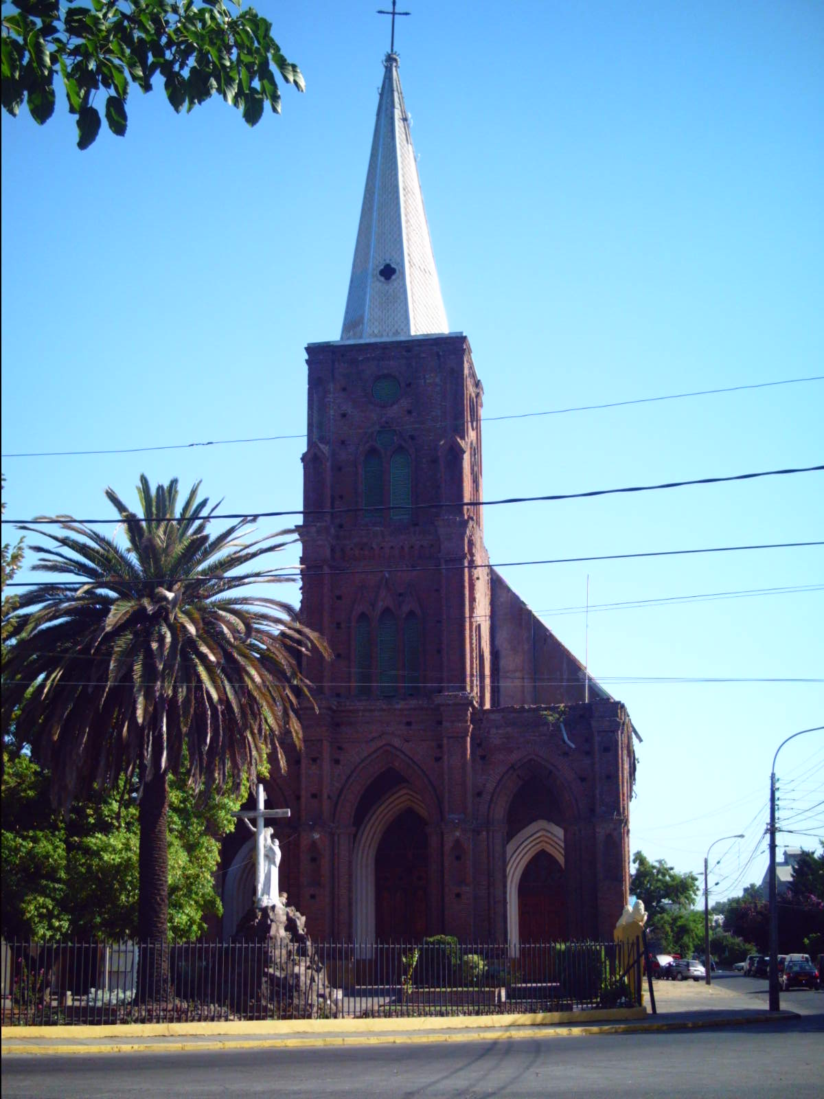
The oldest and most valuable building of the city is La Iglesia San Francisco ("San Francisco's Church"), built in 1734, and came to its current location in 1759.
Curicó gained city status in 1830. Luis Cruz Martínez, a Chilean military figure, is celebrated as the city's hero, and Curicó serves as a central hub for communication, commerce, and the economy of nearby agro-industries.
The 2010 Chilean Earthquake heavily impacted Curicó, causing the collapse of the historic district where sixty percent of houses and ninety percent of the district remain unreconstructed. Examples include the phased inauguration of the San José de Curicó Hospital.
Curicó is known for its strong local identity, fostered by a good neighborhood atmosphere, hero Luis Cruz Martínez, and its football club.
Geography
[edit]Curicó is on the Guaiquillo River, 183 km (114 mi) south of Santiago along the route of the Chilean Central Railway. The city is situated in the fertile Chilean Central Valley, 228 m (748 ft) above sea-level, in the midst of a comparatively well-cultivated region.[5] The eastern and western sides are mountainous, separated by the Chilean Central Valley. A volcano called Descabezado Grande can be seen from most parts at a distance of eighty kilometers. The commune spans an area of 1,328.4 km2 (513 sq mi).[2]
The main rivers are the Lontué River and Teno River, which surround the city. The landscape is dominated by the Andes and Chilean Coastal Range.
Climate
[edit]Curicó has a warm-summer Mediterranean climate (Köppen climate classification Csb), relatively hot dry summers (November to March) with temperatures reaching 32 °C (90 °F) on the hottest days. Winters (June to August) are more humid, with typical maximum daily temperatures of 15 °C (59 °F). Mean rainfall is 855.98 mm (34 in) per year. In August 2007, Curicó experienced snowfall for the first time in over 60 years.[citation needed]
In the southern part of the valley the climate is more temperate and rainfall more abundant; the effects of this are to be seen in better pasturage. Irrigation is used to a large extent.[5]
| Climate data for Curicó (General Freire Airfield) 1991–2020, extremes 1950–present | |||||||||||||
|---|---|---|---|---|---|---|---|---|---|---|---|---|---|
| Month | Jan | Feb | Mar | Apr | May | Jun | Jul | Aug | Sep | Oct | Nov | Dec | Year |
| Record high °C (°F) | 37.3 (99.1) |
37.4 (99.3) |
35.2 (95.4) |
32.2 (90.0) |
27.5 (81.5) |
21.7 (71.1) |
22.8 (73.0) |
25.9 (78.6) |
29.6 (85.3) |
31.7 (89.1) |
36.6 (97.9) |
36.6 (97.9) |
37.4 (99.3) |
| Mean daily maximum °C (°F) | 30.3 (86.5) |
29.5 (85.1) |
26.8 (80.2) |
21.0 (69.8) |
15.9 (60.6) |
12.5 (54.5) |
12.3 (54.1) |
14.8 (58.6) |
17.8 (64.0) |
21.2 (70.2) |
25.4 (77.7) |
28.4 (83.1) |
21.3 (70.3) |
| Daily mean °C (°F) | 21.6 (70.9) |
20.8 (69.4) |
18.5 (65.3) |
14.1 (57.4) |
10.8 (51.4) |
8.6 (47.5) |
7.9 (46.2) |
9.6 (49.3) |
11.8 (53.2) |
14.5 (58.1) |
17.6 (63.7) |
20.0 (68.0) |
14.7 (58.5) |
| Mean daily minimum °C (°F) | 12.8 (55.0) |
12.0 (53.6) |
10.2 (50.4) |
7.2 (45.0) |
5.7 (42.3) |
4.6 (40.3) |
3.5 (38.3) |
4.4 (39.9) |
5.8 (42.4) |
7.7 (45.9) |
9.8 (49.6) |
11.7 (53.1) |
8.0 (46.4) |
| Record low °C (°F) | −0.8 (30.6) |
0.8 (33.4) |
−2.0 (28.4) |
−6.0 (21.2) |
−8.1 (17.4) |
−7.6 (18.3) |
−9.8 (14.4) |
−7.5 (18.5) |
−7.4 (18.7) |
−4.2 (24.4) |
0.0 (32.0) |
0.9 (33.6) |
−9.8 (14.4) |
| Average precipitation mm (inches) | 2.6 (0.10) |
3.4 (0.13) |
9.3 (0.37) |
32.3 (1.27) |
102.1 (4.02) |
159.1 (6.26) |
102.7 (4.04) |
93.2 (3.67) |
46.5 (1.83) |
26.3 (1.04) |
9.3 (0.37) |
9.2 (0.36) |
596.0 (23.46) |
| Average precipitation days (≥ 1.0 mm) | 0.4 | 0.3 | 0.8 | 3.1 | 5.6 | 9.1 | 7.0 | 6.6 | 4.0 | 2.8 | 1.0 | 0.8 | 41.5 |
| Average relative humidity (%) | 51 | 54 | 60 | 71 | 81 | 86 | 84 | 79 | 73 | 66 | 58 | 53 | 68 |
| Mean monthly sunshine hours | 363.7 | 315.3 | 265.3 | 174.3 | 109.4 | 78.9 | 102.5 | 132.8 | 167.6 | 227.6 | 296.6 | 335.4 | 2,569.4 |
| Source 1: Dirección Meteorológica de Chile (humidity 1970–2000)[7][8][9] | |||||||||||||
| Source 2: NOAA (precipitation days 1991–2020)[10] | |||||||||||||
Demographics
[edit]According to the 2012 census of the National Statistics Institute, Curicó spans an area of 1,328.4 km2 (513 sq mi) and has 147,017 inhabitants (68,768 men and 70,817 women). Of these, 130,506 (84%) lived in urban areas and 19,079 (16%) in rural areas. Between the 1992 and 2002 censuses, the population grew by 14.9% (15,472 persons).[2]
Economy
[edit]Primary sector
[edit].jpg)
The city's main economy relies heavily on agricultural activities, particularly large fruit plantations like apple orchards, cherry trees, vineyards, and kiwi farms, along with annual crops such as sugar beets, industrial tomatoes, wheat, corn, and fresh vegetables. Fruit-exporting companies like Agricom, Unifrutti, Copefrut, Del Monte, and others operate in the area. The city is also home to wineries like Viña San Pedro, Concha y Toro, and Santa Rita, producing wine for both domestic and international markets.
Secondary and tertiary sectors
[edit]
In the tertiary sector, the city offers a full range of services, including financial institutions, transportation, department stores, professional institutes, universities, healthcare facilities, and entertainment options. In 2012, the country's largest particleboard panel plant, owned by Arauco, commenced operations.
In 2007, the region's major shopping center, Mall Curicó (105,000 m2), owned by Inmobiliaria Mall Viña del Mar S.A., was inaugurated. Anchor stores like Ripley, París, Jumbo, and Easy attract visitors. The mall expanded in 2018, introducing the first H&M store between Santiago and Concepción. In 2019, a unique gastronomic boulevard opened, featuring stores like Burger King, Starbucks, Manarola, and La Serrana. The expansion also brought Cineplanet and the Apple product retail store MacOnline to the area.
In 2019, Mercado Quadra started operations, including the opening of a Tottus supermarket. Future plans include a gym by Energy and additional commercial spaces.
In 2018, Curicó had 5,562 registered companies. The Economic Complexity Index (ECI) for that year was 1.77. Key economic activities with high Revealed Comparative Advantage (RCA) indices were the Manufacture of Bituminous Mixtures (41.15), Production of Flower, Meadow, Fruit, and Vegetable Seeds (39.54), and Production in Nurseries, Except Forest Species (28.5).
Tourism and society
[edit]| population trend | |
|---|---|
| year | inhabitants |
| 1895 | 12,669 |
| 1952 | 28,618 |
| 1960 | 34,646 |
| 1970 | 43,524 |
| 1982 | 63,658 |
| 1992 | 77,733 |
| 2002 | 119,585 |
| 2005 | 120,113 |
Curicó, a city characterized by its wine culture, hosts the Fiesta de la Vendimia ("Wine Harvest Festival") annually from March 15 to 20. This celebration reflects the rich tradition of Creole culture and the city's history, influenced by nearly five centuries of winemaking. Curicó boasts a wine route through the valley.

The Plaza de Armas, designated a "Typical Zone," is a major attraction adorned with sixty phoenix palm trees from the Canary Islands. It features sculptures, water fountains, and an Eiffel-style iron kiosk declared a National Monument. The square includes bronze busts of the city's founder, José Antonio Manso de Velasco, and a monument to the toqui Lautaro, carved by sculptor Heraclio Calquín.
The city's traditional cakes, known as "tortas curicanas," are popular among locals and tourists alike. Tortas Montero gained international recognition in 1995 by entering the Guinness World Records for creating the world's largest cake.
Cerro Condell, a prominent hill in the city center, is a popular spot during national holidays, offering panoramic views, recreational areas, and the Immaculate Conception monument. The Alameda Antonio Manso de Velasco avenue, adorned with gardens and trees, intersects the city, leading to the San Francisco church. Additionally, Potrero Grande, located around 30 km from Curicó, attracts nature enthusiasts with its mountainous terrain, forests, and waterfalls, ideal for hiking.
-
 The main parish church around main square.
 -
 Luis Cruz Martínez, hero from Curicó.
 -
 San Francisco Church, before being destroyed in the 2010 earthquake
 -
 Curicó, Alameda, 2012
 -
 Cerro Condell, Curicó
 -
 Correos de Chile (Post office) and Curicó's Municipalidad (City hall)
 -
 Kiosk in Curicó's Plaza de Armas


Education
[edit]The city has two universities:
- Universidad de Talca (Traditional-Public), [1]
- Universidad Católica del Maule (Traditional-Religious), [2]
Higher-education institutions:
- Instituto Profesional DuocUC of the Pontificia Universidad Católica de Chile
- Instituto Profesional AIEP of the Universidad Andrés Bello
Media
[edit]The city has one of the oldest newspapers in Chile, La Prensa de Curicó (Press of Curico), founded in 1898.[11] Before the earthquake of 2010, its offices were located in front of the central square, but have been relocated since because the building collapsed.
-
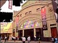 Victoria Theatre
 -
 Diario La Prensa


Notable people
[edit]- Jorge Eduardo Álvarez (born 1990), Chilean footballer
- Jorge Castro de la Barra (born 1953), Chilean radio and television personality and fraudster
Sports
[edit]Curicó is known for its bicycle culture. Many Chilean cyclists of international level started riding in the city, such as Marco Arriagada, Marcelo Arriagada and Luis Fernando Sepúlveda.
The local football team is Club Provincial Curicó Unido.
Administration
[edit]As a commune, Curicó is a third-level administrative division of Chile administered by a municipal council, headed by an alcalde who is directly elected every four years. Currently, the 2024-2028 alcalde is George Bordachar Sotomayor.
Within the electoral divisions of Chile, Curicó is represented in the Chamber of Deputies by Roberto León (PDC) and Celso Morales (UDI) as part of the 36th electoral district, together with Teno, Romeral, Molina, Sagrada Familia, Hualañé, Licantén, Vichuquén and Rauco. The commune is represented in the Senate by Juan Antonio Coloma Correa (UDI) and Andrés Zaldívar Larraín (PDC) as part of the 10th senatorial constituency (Maule-North).
See also
[edit]- (in German) Census of Population in Chile
Sources
[edit]- ^ "Municipality of Curicó" (in Spanish). Archived from the original on 5 November 2013. Retrieved 4 November 2013.
- ^ a b c d e "National Statistics Institute" (in Spanish). Retrieved 28 July 2010.
- ^ "Chile Time". WorldTimeZones.org. Archived from the original on 2007-09-11. Retrieved 2010-07-28.
- ^ "Chile Summer Time". WorldTimeZones.org. Archived from the original on 2007-09-11. Retrieved 2010-07-28.
- ^ a b c One or more of the preceding sentences incorporates text from a publication now in the public domain: Chisholm, Hugh, ed. (1911). "Curicó". Encyclopædia Britannica. Vol. 7 (11th ed.). Cambridge University Press. pp. 643–644.
- ^ a b Cervantes, Biblioteca Virtual Miguel de. "Historia de Curicó". Biblioteca Virtual Miguel de Cervantes (in Spanish). Retrieved 2024-01-20.
- ^ "Datos Normales y Promedios Históricos Promedios de 30 años o menos" (in Spanish). Dirección Meteorológica de Chile. Archived from the original on 23 May 2023. Retrieved 23 May 2023.
- ^ "Temperatura Histórica de la Estación General Freire, Curicó Ad. (340031)" (in Spanish). Dirección Meteorológica de Chile. Archived from the original on 23 May 2023. Retrieved 23 May 2022.
- ^ "Estadistica Climatologica Tomo I" (PDF) (in Spanish). Dirección General de Aeronáutica Civil. March 2001. pp. 488–558. Archived from the original (PDF) on 30 June 2017. Retrieved March 17, 2014.
- ^ "General Freire Curicó Climate Normals 1991–2020". World Meteorological Organization Climatological Standard Normals (1991–2020). National Oceanic and Atmospheric Administration. Archived from the original on 6 August 2023. Retrieved 6 August 2023.
- ^ La Prensa de Curicó
- (in Spanish) [3] History of Curicó by Tomás Guevara
- [4] Information about cultural life and tourism.
- [5] Report about urbanization in Latin American cities.
External links
[edit]- (in Spanish) Official Website
- (in Spanish) News about Curico
- Information about Wine Route
- Satellite Images of Curico by Google Maps

| International | |
|---|---|
| National | |
| Geographic | |
| Other | |
Curicó
View on GrokipediaCuricó is a city and commune serving as the capital of Curicó Province in Chile's Maule Region, located in the Central Valley near the Mataquito River.[1] Founded on 9 October 1743 as San José de Buena Vista de Curicó during Spanish colonial rule, it gained official city status in 1830 and has since developed into a prominent agro-industrial center.[2] The commune spans 1,328 square kilometers and, per the 2024 national census conducted by Chile's Instituto Nacional de Estadísticas, houses 159,968 residents.[1] Positioned at 228 meters above sea level in a fertile zone with a Mediterranean climate of cool, dry summers and mild, rainy winters, Curicó thrives on agriculture, particularly viticulture in the Curicó Valley, producing reliable red and white wines from varieties such as Cabernet Sauvignon, Carmenère, and Chardonnay.[3] This economic backbone includes exports of wine, fruits, cement, sugar, and tomato products, bolstered by major wineries like Miguel Torres and San Pedro that emphasize sustainable practices across extensive vineyards.[3] The city's growth as a service and trading hub supports surrounding rural areas, though it has endured seismic events, including devastating earthquakes in 1928 and 2010 that prompted reconstructions of landmarks like the San Francisco Church.[2]
Etymology and Symbolism
Name Origin
The name Curicó derives from the Mapudungun language spoken by the Mapuche people, composed of kürü ("black" or "dark") and ko ("water"), literally meaning "black water" or "dark water." This etymology likely references the dark, sediment-laden appearance of rivers in the region, such as the Mataquito River, which flows through the area and carries alluvial deposits from upstream Andean sources.[4][5][6] The pre-colonial inhabitants of the Curicó territory were indigenous groups known as the Curis ("the blacks"), a designation applied by neighboring tribes to denote either their darker skin tones or association with the territory's eponymous dark waters. These groups, part of the broader Picunche or Promaucaes peoples, adopted the territorial name, which Spanish colonizers later retained for the founded city in 1743.[7]Coat of Arms and Flag
The coat of arms of Curicó features a silver knight mounted on a black horse traversing a green field, wielding a lance to slay a golden serpent; this imagery symbolizes nobility, loyalty, and triumph over adversity.[8][9] The shield is topped with a golden mural crown of five towers and inscribed at the base with "Curicó."[8] This emblem constitutes a readaptation of the personal arms granted to maestre de campo Lorenzo de Labra y Corvalán de Castilla, whose estate supplied the foundational territory for the city in 1743.[8] Curicó, unlike nearby Talca, lacked a royal Spanish privilege for municipal arms; the design received formal municipal adoption on March 11, 1943, marking the bicentennial of the city's establishment. The flag of Curicó commune, employed in civic and administrative capacities, derives its elements from the coat of arms, reflecting local heraldic tradition.[10]History
Pre-Columbian and Colonial Foundations
The region encompassing modern Curicó was inhabited during the pre-Columbian era by the Picunche (also known as Promaucae), an indigenous group belonging to the Mapuche linguistic and cultural family, who occupied the central Chilean valley from the Maule River northward. These communities were primarily agricultural, cultivating maize, potatoes, quinoa, beans, and chili peppers on fertile alluvial soils along rivers such as the Claro and Teno, supplemented by hunting, fishing, and gathering. They lived in semi-sedentary villages of rucas (reed-thatched huts) clustered under local caciques, with social organization centered on kinship and tribute systems rather than large centralized polities; archaeological sites in the Maule Valley reveal ceramic traditions, ground stone tools, and burial practices indicative of chiefdom-level complexity dating back to at least 1000 CE.[11] Spanish penetration into the Curicó area followed Pedro de Valdivia's conquest of central Chile in the 1540s, with the region incorporated into the colonial encomienda system granting indigenous labor to Spanish settlers, though ongoing resistance from southern Mapuche groups limited dense settlement north of the Biobío River. Early land grants facilitated hacienda development; on December 14, 1625, Governor Luis Fernández de Córdova awarded 1,000 cuadras (approximately 1,300 hectares) in the Quiagüe area—near present-day Curicó—to Juan Ortiz de Espinosa, establishing one of the first private estates in the vicinity and drawing Franciscan missionaries who built a convent by 1735 to evangelize local Picunche remnants. These efforts reflected broader colonial strategies to exploit agricultural potential while maintaining a buffer against indigenous incursions, with the area remaining sparsely populated by scattered estancias amid vast indigenous lands.[12][13] The formal establishment of Curicó as a villa occurred on October 9, 1743, when Governor José Antonio Manso de Velasco, acting on royal directives to fortify the intermediate frontier, founded San José de Buena Vista de Curicó at the confluence of the Claro and Guaiquillo rivers. This site was selected after initial plans for a location further east proved unfeasible due to terrain and land availability, with the founding acta documenting contributions of solares (urban plots) and ejidos (common lands) from local vecinos to attract 30 founding families comprising Spanish, criollo, and mestizo settlers. The initiative formed part of Manso de Velasco's campaign to populate six new villas in central Chile between 1741 and 1747, aiming to secure loyalty, boost wheat production for export, and dilute indigenous demographic majorities through Hispanicization and reducciones (forced resettlements).[14][15][16]Independence Era and 19th-Century Development
During the Chilean War of Independence (1810–1826), Curicó, then a colonial outpost under Spanish royalist control, saw limited direct engagements but contributed through local patriot resistance. The city was not a site of major battles, yet inhabitants formed guerrilla bands to harass Spanish forces and support the patriot cause led by figures like José de San Martín and Bernardo O'Higgins. In January 1817, Francisco Villota Pérez Cotapos, commissioned by the Army of the Andes to organize resistance in the region, led a force of approximately 120 men in an unsuccessful assault on Curicó, aiming to disrupt royalist supply lines; the group included local leaders such as Matías Ravanal, Manuel Antonio Labbé, and Joaquín Fermandois, who later joined larger patriot efforts.[17][18] Villota, a landowner from the area, mobilized rural support between San Fernando and Curicó, reflecting broader creole discontent with colonial rule, though his efforts faced setbacks from entrenched royalist loyalties in the town.[19] Following independence, Curicó transitioned to republican administration. On August 10, 1830, it received official city status from the Chilean government under President Francisco Antonio Pinto, elevating it from villa to ciudad and designating it the temporary capital of Colchagua Province until 1840.[20][21] This recognition coincided with national stabilization after the 1829 civil conflicts, enabling local governance reforms and integration into Chile's emerging constitutional framework. The period also saw the emergence of figures like Luis Cruz Martínez, a native son who rose to prominence in the 1836–1839 War against the Peru-Bolivian Confederation, exemplifying Curicó's continued military contributions to national defense. In the mid-19th century, Curicó's development accelerated through agricultural expansion in the fertile Maule Valley, fueled by Chile's cereal export boom to Europe and California during the 1849 Gold Rush. Wheat cultivation dominated, with local haciendas adopting improved plows and crop rotation, boosting output amid fluctuating global demand; by the 1850s, central valley agriculture, including Curicó's, accounted for much of Chile's export growth, reaching peaks before market corrections in the 1870s.[22] Viticulture emerged as a secondary pillar, with mid-century introductions of European techniques—such as better pruning and barrel aging—enhancing wine quality in Curicó's valleys, though large-scale commercialization intensified only toward century's end.[23] Urban infrastructure followed, including the 1861 arrival of the Santiago-Talca railway extension, which connected Curicó to ports and markets, spurring trade and population influx; by 1865, it formed a departmental capital, reflecting steady modernization despite reliance on latifundia-based agriculture.[21][11]20th-Century Growth and Challenges
In the early 20th century, Curicó experienced infrastructural modernization that facilitated economic and urban expansion, including the extension of the railway line to the city in 1906, which enhanced connectivity for agricultural exports, and the inauguration of the Kiosko Cívico in the Plaza de Armas that same year.[21] Agricultural cooperatives emerged as key drivers of growth, such as the Cooperativa Vitivinícola in 1922 and the Cooperativa Frutícola in 1954, bolstering the region's focus on fruit and wine production amid Chile's broader agrarian economy.[21] By 1960, the commune's population had reached 107,160, reflecting steady demographic increases tied to job opportunities in agroindustry and services.[21] Mid-century developments included public works like the Velódromo in 1953 and expanded telephone infrastructure by 1962, supporting commerce and urbanization in emerging neighborhoods.[21] The city's economy solidified as an agro-industrial hub, with viticulture and fruticulture generating employment and exports, though dependent on favorable climates and markets.[11] Curicó faced recurrent seismic challenges, including the 1928 earthquake on December 1, which devastated nearby Talca and caused significant damage in Curicó, contributing to 279 deaths across the Maule region.[24] The 1939 Chillán earthquake inflicted structural harm, while the 1960 Valdivia event and 1985 central Chile quake (magnitude 8.0) further strained infrastructure and recovery efforts.[21] These disasters, compounded by national economic volatility such as inflation and recessions in the 1930s and 1970s, periodically disrupted growth, necessitating repeated rebuilding and highlighting vulnerabilities in a seismically active zone reliant on agriculture.[25]Post-2010 Earthquake Recovery and Recent Developments
The 8.8-magnitude Maule earthquake on February 27, 2010, devastated Curicó, destroying over 90 percent of its historical center and severely damaging around 1,000 homes, most built with adobe.[26] The local hospital was also rendered unusable, prompting the Argentine Air Force to install a temporary mobile field hospital.[27] Recovery efforts aligned with Chile's national "Reconstruir Mejor" initiative, focusing on resilient infrastructure to mitigate future seismic risks.[28] Housing reconstruction formed a core component, contributing to the nationwide repair or rebuilding of 220,000 units targeted post-earthquake; by 2012, 54 percent of these were completed and occupied, reflecting efficient progress driven by government subsidies and private sector involvement.[29] In Curicó, emphasis was placed on seismic retrofitting and urban renewal, though specific local housing completion rates mirrored regional trends of accelerated construction under emergency protocols.[30] The San Juan de Dios Hospital reconstruction exemplified these efforts: the new US$300 million facility, spanning 109,152 m² across seven floors with 400 beds, 12 surgical suites, and underground parking for 800 vehicles, was inaugurated in April 2021.[27] Post-recovery, Curicó's population grew from 97,484 in March 2010 to 109,315 by April 2019, signaling economic resilience and inward migration.[31] Recent urban developments include mixed-use neighborhood projects like Barrio Modelo Bombero Garrido and new residential complexes such as Puerta Norte, addressing housing demand amid agro-industrial expansion.[32] Infrastructure initiatives, including proposed bypass routes and eastern sector enhancements, support ongoing connectivity and growth as outlined in the communal development plan.[33]Geography
Location and Physical Features
Curicó is situated in the Maule Region of central Chile, serving as the capital of Curicó Province. The city lies within the Chilean Central Valley, approximately 185 kilometers south of Santiago, positioned between the Andean cordillera to the east and the Coastal Range to the west.[34] Its geographic coordinates are approximately 34°59′S latitude and 71°14′W longitude.[35] The urban center of Curicó occupies an elevation of about 228 meters above sea level in a fertile plain characterized by alluvial soils conducive to agriculture. The surrounding terrain features a broad valley floor, with the Mataquito River and Guaiquillo River traversing the area, supporting irrigation and contributing to the region's viticultural prominence.[36] To the immediate east, low hills such as Cerro Condell rise, marking the transition toward the higher Andean slopes, while the western expanse opens toward the coastal lowlands roughly 100 kilometers away. The Curicó commune encompasses diverse physical landscapes, extending from coastal plains in the west to precordilleran foothills in the east, covering an area of approximately 7,281 square kilometers within the province. This varied topography influences local microclimates, with the valley's flatlands providing optimal conditions for crop cultivation amid the enclosing mountain ranges.[37]Climate Patterns
Curicó exhibits a warm-summer Mediterranean climate classified as Csb under the Köppen system, marked by extended dry periods in summer and concentrated rainfall during cooler months influenced by frontal systems from the Pacific.[38] [39] This pattern arises from the region's position in the subtropical high-pressure belt during austral summer, blocking precipitation, while winter westerlies bring moisture. Annual average temperatures reach 14.7°C, with significant seasonal swings: summer highs (December–February) average 29–30°C and lows 12–13°C, peaking in January at a daily high of 29.4°C; winter (June–August) features highs of 15–16°C and lows of 3–5°C, with July as the coldest month averaging 8.2°C.[38] Diurnal ranges are moderate, typically 10–15°C, moderated by the Maule Valley's inland location away from coastal fog but near Andean influences that can amplify föhn winds during transitions. Precipitation averages 832 mm yearly, overwhelmingly winter-focused, with over 70% falling between May and August due to cyclonic activity; June records the peak at 212 mm, while summers receive under 20 mm monthly, enabling agriculture but heightening drought risks in dry years.[38] [40] The rainy season spans March to November but intensifies in mid-year, with events often exceeding 50 mm daily; historical extremes include 59.6 mm in January 2021 (a monthly record since 1950) and 150.2 mm in a single day in 2024, reflecting variability beyond norms.[41] [42] Prolonged dry spells, as in 2019—the driest year since 1961—underscore megadrought influences on the Central Chile pattern, reducing reliability for rain-fed sectors.[43] The following table provides monthly averages for maximum, mean, and minimum temperatures, as well as precipitation:| Month | Avg. Max (°C) | Avg. Mean (°C) | Avg. Min (°C) | Avg. Precip. (mm) |
|---|---|---|---|---|
| January | 31.1 | 22.2 | 13.3 | 3 |
| February | 30.0 | 21.1 | 12.2 | 3 |
| March | 27.2 | 18.9 | 10.0 | 13 |
| April | 21.7 | 14.4 | 7.2 | 30 |
| May | 16.7 | 11.7 | 6.1 | 119 |
| June | 13.3 | 9.4 | 5.0 | 165 |
| July | 12.8 | 8.3 | 3.3 | 130 |
| August | 15.6 | 10.0 | 4.4 | 99 |
| September | 18.3 | 12.2 | 6.1 | 56 |
| October | 21.7 | 14.4 | 7.8 | 25 |
| November | 25.6 | 17.8 | 10.0 | 10 |
| December | 28.9 | 20.6 | 11.7 | 5 |
Geological Risks and Natural Hazards
Curicó lies in a seismically active zone of central Chile, where the Nazca Plate subducts beneath the South American Plate along the Peru-Chile Trench, generating frequent earthquakes and associated hazards such as ground shaking, liquefaction, and landslides. The city has recorded over 8,600 earthquakes within a 150 km radius since the 1950s, with at least three events exceeding magnitude 7 since 1900, underscoring its high seismic vulnerability.[45][46] Seismic hazard maps classify the area in Zone 3, indicating peak ground accelerations up to 0.4g for a 10% probability of exceedance in 50 years, necessitating strict building codes that have mitigated some losses in modern structures. The 2010 Maule earthquake (Mw 8.8), with its epicenter approximately 100 km northeast of Curicó on February 27, exemplifies these risks, causing heterogeneous damage including partial collapses of unreinforced masonry buildings and the Iglesia San Francisco's front tower due to amplification on soft alluvial soils in the urban valley. Microtremor surveys post-event revealed predominant site periods of 0.5–1.0 seconds in damaged zones, correlating with surface geology and explaining intensified shaking compared to bedrock sites. The quake triggered over 1,000 landslides across the Maule Region, some near Curicó, exacerbating infrastructure disruptions like road blockages and soil instability on hillslopes.[47][48][49] Volcanic hazards stem from proximity to active systems like Planchón-Peteroa volcano, about 100 km east, classified as high risk for Curicó with potential ashfall disrupting agriculture and air quality during eruptions, as seen in 2010–2011 plumes reaching altitudes over 10 km. Historical activity, including 1930s emissions from nearby Quizapú, has deposited tephra layers traceable in regional sediments, though direct lava flows pose minimal threat due to distance. Seismic swarms at Laguna del Maule field, 70 km northeast, in 2025 generated 160 tremors in hours, signaling unrest that could indirectly heighten landslide risks via increased seismicity.[50][51][52] Rain-induced landslides and riverine flooding, often linked to geological instability in the Andean foothills, compound hazards during austral winter storms, with a greater than 20% chance of damaging floods in the next decade per hazard assessments. Events like the 2023 El Niño-driven deluges flooded low-lying areas and vineyards, triggering debris flows that blocked routes and highlighted vulnerabilities in sediment-laden catchments of rivers such as the Claro. Mitigation efforts include early warning systems from SERNAGEOMIN and reinforced slopes, though uneven enforcement has left some peripheral zones exposed.[53][54][55]Demographics
Population Dynamics
The population of the Curicó commune, encompassing the city and surrounding rural areas, has exhibited consistent growth driven by agricultural employment opportunities and internal migration from rural zones within the Maule Region. The 2002 national census recorded 119,585 inhabitants, with a population density of approximately 90 inhabitants per square kilometer across the commune's 1,328 square kilometers.[56] This marked an increase from earlier decades, reflecting post-1980s economic stabilization and expansion in viticulture and fruit production that attracted seasonal and permanent workers.[56] By the 2017 census, the population rose to 149,136, representing a 24.7% increase over 15 years, or an average annual growth rate of about 1.5%.[57] Urban areas, particularly the city of Curicó, accounted for the majority, with over 90% of residents concentrated in urban settings by this period, underscoring a trend of rural-to-urban migration fueled by service sector development and infrastructure improvements.[57] Natural population increase, via higher birth rates relative to national averages in agricultural communities, contributed alongside net positive migration balances from neighboring provinces.[58] The 2024 census enumerated 159,968 residents, a 7.2% rise from 2017 over seven years, equating to roughly 1% annual growth—slower than prior decades and below pre-census projections of around 170,000, which had anticipated continued momentum from economic recovery post-2010 earthquake.[59] [57] This deceleration aligns with national trends of declining fertility rates (averaging 1.5-1.6 children per woman in the region) and out-migration of younger cohorts to larger cities like Santiago for education and non-agricultural jobs, though inflows of foreign labor in agribusiness have partially offset losses.[60] Recent dynamics also reflect resilience to seismic events, with post-2010 reconstruction stabilizing rather than accelerating growth through temporary displacement.[59]Ethnic and Social Composition
Curicó's population is overwhelmingly non-indigenous, with residents primarily of mixed European and Amerindian descent (mestizo) or European ancestry, consistent with central Chile's historical settlement patterns dominated by Spanish colonial influences and subsequent European immigration. Self-identified indigenous persons comprise 2.9% of the commune's population as of January 2024, a figure notably lower than the national average of approximately 12%.[61] This minority is predominantly Mapuche, reflecting regional migrations from southern Chile, though concentrated less densely here than in provinces like Araucanía. Socially, the commune features a highly urbanized structure, with 89.7% of the population residing in urban areas as of 2024 projections, underscoring a shift from rural agricultural roots to peri-urban and service-oriented living.[61] Poverty by income affects 7.3% of residents (2022 data), below the national rate of around 10%, signaling a socioeconomic profile bolstered by viticulture, manufacturing, and commerce, though rural pockets retain higher vulnerability tied to seasonal farm labor.[61] Educational outcomes, as measured by national SIMCE tests, position Curicó near regional medians, with 2022 scores for fourth-grade reading at 272 points and mathematics at 257 points, indicative of moderate social mobility amid Chile's broader inequalities.[61]Migration and Urban Growth
Curicó's population grew from 104,113 inhabitants in 1992 to 119,585 in 2002, reflecting a 14.9% increase over the decade, with projections reaching 150,024 by 2020 according to Instituto Nacional de Estadísticas (INE) estimates cited in municipal planning documents.[62] This expansion was accompanied by a rising urban share, from 77.2% (80,343 urban residents) in 1992 to 84% (100,506 urban) in 2002, signaling accelerated urbanization amid Chile's broader national trend toward 88% urbanization by 2023.[62][63] Internal migration, particularly rural-to-urban flows within the Maule Region, has been the primary driver of this urban growth, as Curicó functions as a regional hub for services, commerce, and agro-industry, attracting working-age individuals from surrounding rural areas like Tutuquén Alto and Convento Viejo.[62] These movements counter rural depopulation and aging, where out-migration of economically active youth reduces local labor forces and exacerbates demographic imbalances, with rural sectors showing low birth rates and higher dependency ratios.[62] Inter-communal inflows from other Maule locales further bolster urban density, though recent INE census analysis indicates a net migration saldo of -1,204 for Curicó, suggesting outflows—possibly to larger centers like Santiago—outpacing inflows in the latest period.[60] International migration contributes marginally, with foreign residents concentrated in urban Talca and Curicó but comprising a small fraction of the commune's demographics, primarily from neighboring South American countries seeking agricultural or service employment.[64] Urban expansion has manifested in peripheral developments, including new housing zones in Rauquén, El Boldo, Santa Fe, and Sarmiento, alongside commercial nodes along Avenida España, converting agricultural land into residential and retail areas—such as in the Norponiente sector—and increasing housing stock by 40.9% from 24,675 units in 1992 to 34,775 in 2002.[62] This sprawl has heightened density in the central Depresión Intermedia, with high-rise constructions and improved connectivity via ciclovías planned to mitigate congestion, though challenges persist in infrastructure like streets, sidewalks, and public spaces.[62] By 2023 projections from Biblioteca del Congreso Nacional data (drawing on INE), the commune's population approached 169,681, underscoring sustained growth despite migration pressures, tied to Curicó's role as an intermediate city with 46% of employment in agriculture supporting urban-rural linkages.[57][62]Economy
Primary Sector: Agriculture and Viticulture
The primary sector of Curicó's economy is dominated by agriculture, with viticulture as a cornerstone due to the valley's Mediterranean climate, alluvial soils, and access to irrigation from the Teno and Lontué rivers, which support extensive cultivation.[37] The region produces a range of fruits and table grapes alongside wine grapes, contributing significantly to Chile's export-oriented agricultural output, though specific hectare data for non-viticultural crops in Curicó remains limited in recent surveys.[65] Viticulture spans approximately 19,000 to 22,000 hectares in the Curicó Valley, positioning it as one of Chile's key winegrowing areas within the broader Maule region, which holds about 38% of national vineyard acreage.[66][67] Cabernet Sauvignon constitutes over one-third of plantings, followed by Carménère and Merlot for reds, while whites—led by Sauvignon Blanc and Chardonnay—account for around 40% of production, reflecting the valley's emphasis on versatile, volume-oriented wines rather than premium varietals.[68][34] The sub-regions of Lontué (red-focused) and Teno (balanced varietals) yield affordable, approachable wines, with national wine output in 2022 reaching 1.244 billion liters, of which Maule valleys like Curicó contributed substantially through bulk and bottled exports.[69][65] Beyond grapes, fruit orchards—particularly apples, cherries, and kiwis—form a vital component, leveraging the area's temperate conditions for high-yield deciduous crops that support both domestic markets and exports.[37] Recent challenges include variable harvests influenced by climate trends, such as drier conditions since the 1980s, prompting shifts toward sustainable irrigation and varietal adaptation in local farming practices.[70]Secondary and Tertiary Sectors: Industry and Services
The secondary sector in Curicó centers on manufacturing, particularly agroindustrial processing tied to the region's agricultural output, including wine production, fruit and olive oil milling, and food processing such as sugar and tomato sauce. Key facilities encompass cement production, textiles, bakeries, tanneries, foundries, sawmills, and metallurgical operations, concentrated in designated industrial zones under the 2011 Plan Regulador Comunal.[62] In 2021, the manufacturing subsector employed 5,035 workers across 1,173 companies, representing approximately 5.6% of the commune's total workforce of 89,552.[57] This sector issued 248 industrial patents in 2016, reflecting modest expansion from 790 enterprises in 2009 to 1,061 in 2014.[62] Notable examples include Agroindustrial Siracusa's olive oil milling operations in the Curicó Valley, which have garnered international awards for premium extra virgin varieties since establishing modern facilities.[71] Vitivinicultural processing remains prominent, leveraging the Maule Valley's terroir for export-oriented wine bottling and aging, though the sector faces challenges like factory emissions and geological hazards in southern industrial areas.[62] The tertiary sector dominates Curicó's non-agricultural economy, functioning as a regional hub for commerce, finance, health, and professional services along the Pan-American Highway. Commerce leads with 4,912 companies in 2021 employing 8,892 workers, supported by retail outlets, wholesale distribution, and modern malls catering to urban and rural consumers.[57] Health services involve 374 establishments serving over 131,000 residents as of 2012, anchored by facilities like Hospital San Juan de Dios, while education encompasses 154 institutions with 2,904 staff in 2021, including technical training in industrial mechanics and agribusiness.[57][62] The sector issued 5,858 commercial patents in 2016, with enterprises growing from 3,376 in 2009 to 3,693 in 2014, comprising about 11% direct employment but broader contributions through ancillary roles.[62] Tourism services promote events like the Fiesta de la Vendimia since the 1950s and rural sites such as Tutuquén, though development lags due to infrastructural deficits like street congestion and limited statistical tracking.[62] Financial institutions and logistics further bolster connectivity, positioning Curicó as the agroindustrial capital with sustained growth in service-oriented intermediation.[62]Economic Performance, Challenges, and Policy Impacts
Curicó's economy, integrated within the Maule Region's agricultural framework, exhibited modest growth in line with regional trends, with the Maule recording a 0.8% GDP increase in 2023, propelled by the extractive, gas, and agriculture (EGA) sector alongside personal services.[72] The region contributes over 20% to Chile's national silvoagropecuario GDP and approximately 4% to total GDP, underscoring Curicó's role in fruit production, viticulture, and related exports that benefited from Chile's 2024 wine export surge in both volume and value.[73] Commerce emerged as the leading employer regionally in late 2024, reflecting diversification efforts amid agricultural seasonality, though unemployment remains elevated compared to national averages, with Maule ranking among Chile's higher rates in prior years.[74] Key challenges stem from vulnerability to natural hazards, notably the February 27, 2010, earthquake (magnitude 8.8), which demolished Curicó's historic core, collapsed infrastructure, and inflicted widespread economic disruption across the Maule, contributing to national damages equivalent to 18% of GDP.[75] Rural reconstruction post-event faced delays in housing and production recovery, exacerbating short-term losses in agriculture-dependent livelihoods.[76] Persistent drought, intensified by climate variability, has strained water resources critical for Curicó's orchards and vineyards, with Maule declaring scarcity zones and facing reduced yields amid rising input costs.[77] These factors, compounded by increasing foreign ownership of farmlands—controlling about 20% of fruit exports nationally—have heightened local concerns over control and profitability.[78] National agricultural policies, emphasizing export orientation since the 1970s reforms, have positively impacted Curicó by enhancing market access for Maule's fruits and wines, which constitute key components of Chile's southern hemisphere export leadership.[79] Post-2010 reconstruction initiatives, including fiscal allocations for infrastructure and housing, facilitated economic rebound by prioritizing territorial development and emergency aid, though implementation gaps prolonged rural vulnerabilities.[80] However, limited state investment in regional irrigation and diversification—despite Maule's 17% share of national cropland—has perpetuated dependency on weather-sensitive sectors, with critiques noting insufficient adaptation to scarcity despite export gains.[81] Recent regional strategies, such as the Maule 2042 Development Plan, seek to address these through sustainable innovation, but outcomes hinge on coordinated national support.[82]Government and Politics
Local Administration
The local administration of Curicó is governed by the Ilustre Municipalidad de Curicó, established under Chilean municipal law as the primary executive and administrative body for the comuna. The municipality is headed by the alcalde, George Bordachar Sotomayor, who was inaugurated for the term December 6, 2024, to December 5, 2028.[83] The alcalde oversees daily operations, policy implementation, and coordination with regional authorities, including responsibilities for public services, urban planning, and community development.[84] The Municipal Council (Concejo Municipal) serves as the legislative branch, comprising elected concejales who approve budgets, ordinances, and major initiatives. The current council for 2024-2028 includes members such as Constanza de Jesús Pinto Muñoz, Francisco Javier Sanz Abad, Ivette Cheyre Serrano, and Mario Undurraga, among others, reflecting a mix of political affiliations elected in the October 2024 municipal elections.[85][86] Council sessions, held regularly, address local issues like infrastructure, public safety, and fiscal matters, with proceedings available through official channels.[87] Administratively, the municipality operates through a hierarchical structure under the alcalde, including key directorates such as the Dirección de Desarrollo Comunitario (DIDECO) for social services and citizen participation; Dirección de Administración y Finanzas for budgeting and procurement; Dirección de Obras Municipales for infrastructure; and specialized units like Seguridad Pública, Tránsito, and Gestión Ambiental.[88] The Secretaría Municipal handles coordination for the alcalde and council, while the Administrador Municipal, Oscar Marcelo Fernández Vilos, supports overall management from the central office at Calle Estado 279.[89] This framework ensures decentralized service delivery, with subunits focusing on areas like aseo (waste management), transport, and legal advisory.[90] The municipal budget for 2024 totaled approximately 44.5 billion Chilean pesos in perceived income, funding operations across these units, though challenges like fiscal constraints and post-earthquake recovery influence allocations.[91] Transparency is maintained via public reports and the PLADECO (Plan de Desarrollo Comunal) for 2017-2024, guiding long-term priorities despite periodic updates.[62]Electoral Representation and Political Trends
In the municipal elections held on October 26–27, 2024—the first under Chile's system of automatic voter registration and compulsory voting—George Bordachar Sotomayor, an independent candidate with prior ties to the right-wing Renovación Nacional party, won the mayoralty of Curicó with 37.19% of the valid votes, defeating contenders including Javier Ahumada of the center-left Contigo Chile Mejor pact who received 25.34%.[92] [93] Voter turnout reached approximately 50% across the commune, reflecting partial engagement despite the mandatory framework.[94] The Curicó communal council for the 2024–2028 period consists of ten councilors elected via proportional representation, with notable gains by right-wing parties. Elected members include Constanza de Jesús Pinto Muñoz of the conservative Partido Republicano (5,806 votes, 6.90%), Francisco Javier Sanz Abad of Renovación Nacional (5,433 votes, 6.45%), Ivette Cheyre Serrano (reelected, independent), and Mario Undurraga Castelblanco, among others such as Edgardo Antonio Reyes Reyes.[86] [85] This composition provides the mayor with a supportive majority inclined toward center-right priorities, including security, economic development, and fiscal restraint. Electoral trends in Curicó indicate a pivot to the right following the 2016–2024 administration of Javier Muñoz Riquelme, a Partido Demócrata Cristiano figure associated with centrist governance focused on social services and infrastructure. Bordachar's victory aligns with broader regional patterns in the Maule Region, where agricultural communities like Curicó have shown growing preference for candidates emphasizing law and order, rural economic policies, and criticism of central government interventions under the leftist administration of President Gabriel Boric (2022–present).[95] Historical municipal contests, such as those in 2016 and 2021, featured competitive races between center and center-left coalitions, but 2024's results underscore voter fatigue with establishment parties and a tilt toward independents and conservatives amid post-2019 social unrest and economic pressures.[96]Culture and Society
Cultural Heritage and Traditions
Curicó's cultural heritage prominently features its Plaza de Armas, founded in 1743 alongside the city's establishment and designated a Zona Típica in 1986 under Decree 01156 for its exceptional architectural, artistic, and landscape qualities. The plaza encompasses key historic structures including the Municipalidad de Curicó, Iglesia Matriz, Club de la Unión, and Liceo de Niñas Fernando Lazcano, enhanced by 60 Phoenix canariensis palms, a French-imported fountain installed in 1865 depicting three nymphs, and a New Orleans-inspired kiosk erected in 1905, which was declared a Monumento Histórico Nacional in 1978. These elements reflect 19th- and 20th-century urban beautification efforts, positioning the plaza among Chile's most aesthetically preserved public spaces.[97][98] Local traditions are deeply intertwined with the region's agricultural and viticultural legacy, dating to the 19th century. The Fiesta de la Vendimia, launched in 1986 by Spanish enologist Miguel A. Torres to merge Chilean and Iberian customs, stands as Chile's inaugural major grape harvest festival and has evolved into a cornerstone event emphasizing wine production, regional gastronomy, artisan crafts, and heritage through dedicated music stages. Typically held in March, it includes wine blessings, tastings, and performances of traditional folk music, though editions were suspended from 2020 to 2022 amid the COVID-19 pandemic before resuming in 2023.[99] Complementing these, huaso culture—symbolizing Chile's rural equestrian and pastoral ethos—permeates Curicó's communal life, manifesting in literature, music, and events that honor cowboy attire, horsemanship, and folk expressions tied to the central valley's agrarian history. Annual fiestas costumbristas, such as the 2025 edition inaugurated on October 10 during the city's anniversary celebrations, showcase these through exhibits of typical foods, dances, artisanal goods, and live demonstrations in venues like the Alameda Manso de Velasco, fostering preservation of rural customs amid urban growth.[100][101][102]Tourism Attractions
Curicó's tourism centers on its historic urban core, wine production heritage, and proximity to natural reserves in the Maule Region. The Plaza de Armas, established in the colonial era, functions as the city's main public square, surrounded by palm trees, fountains, and neoclassical buildings including the municipal theater and post office; it hosts seasonal markets and events drawing local visitors.[103][104] The Victoria Theatre, dating to 1910, offers cultural performances and architectural tours, preserving early 20th-century design elements amid the city's central zone.[105] Wine tourism dominates regional appeal, with the Curicó Valley featuring over 10,000 hectares of vineyards producing Carmenère and Sauvignon Blanc varietals; guided tours at estates like Viña Miguel Torres, operational since 1979, include tastings and harvest observations from March to April.[106][37] The Ruta del Vino pathway connects multiple bodegas, contributing to Chile's export-oriented wine industry valued at $1.2 billion annually as of 2023.[103][107] Outdoor attractions include Cerro Condell, a 200-meter urban hill providing panoramic views of the Andean foothills and valley; trails here support hiking and picnicking year-round. Nearby, Reserva Nacional Radal Siete Tazas, located 70 kilometers east, spans 1,810 hectares with seven natural rock pools formed by the Claro River and accessible via 4-kilometer trails; entry fees are approximately 4,000 Chilean pesos per adult as of 2024, with peak visitation in summer for waterfall scenery.[108][107] Laguna Torca National Reserve, 50 kilometers southwest, offers birdwatching for species like the black-necked swan across 650 hectares of wetlands, emphasizing biodiversity conservation efforts.[106][107] These sites underscore Curicó's blend of cultural preservation and ecological access, though seismic risks from the 2010 earthquake, which damaged structures like the San Francisco Church, necessitate ongoing reconstruction monitoring.[103]Education System
The education system in Curicó aligns with Chile's national framework, comprising preschool (educación parvularia), basic education (八年, ages 6-14), secondary education (cuatro años, ages 14-18), and tertiary institutions. Public schooling at the preschool, basic, and secondary levels is primarily managed by the Dirección de Administración de Educación Municipal (DAEM) de Curicó, which oversees subsidized establishments and focuses on equitable access and quality improvement through annual plans (Planes Anuales de Desarrollo de la Educación Municipal).[109][110] The commune hosts around 56 schools and colleges, encompassing municipal, subsidized private, and nonsubsidized private institutions serving diverse socioeconomic groups.[111] Municipal schools emphasize foundational skills, with recent evaluations via the Sistema de Medición de la Calidad de la Educación (SIMCE) showing notable progress: in 2024, the municipal network recorded historic gains in language and mathematics scores for 4th and 6th basic grades, reflecting targeted interventions in curriculum and teacher training.[112][113] Province-wide SIMCE participation in 2024 included 14,961 students in 4th basic, 14,442 in 6th basic, and 14,271 in 2nd secondary, underscoring broad coverage amid national efforts to address post-pandemic learning gaps.[114] Higher education in Curicó features several campuses and institutes, including the Sede Curicó of Universidad Católica del Maule (UCM), with facilities at Campus Nuestra Señora del Carmen (Carmen 684) and Campus San Isidro Labrador, offering undergraduate programs in fields like education, health sciences, and engineering.[115] Additional options include Instituto Profesional Santo Tomás Curicó, accredited in institutional management and providing technical and professional degrees; INACAP Sede Curicó, focused on vocational training in administration, energy, maintenance, and logistics; and program extensions from Universidad de Talca, emphasizing regional needs such as agriculture and business.[116][117][118] These institutions support local workforce development, particularly in the Maule Region's agro-industrial economy, though enrollment data remains aggregated at the regional level per national reporting.[119]Media Landscape
The dominant print and digital newspaper in Curicó is Diario La Prensa, founded on November 13, 1898, by the brothers Morán Aliaga as a local publication that has since expanded circulation across the Maule Region.[120] Its headquarters remain at Sargento Aldea 632 in Curicó, where it continues daily operations, covering regional news, sports, and legal notices with a focus on local developments.[120] Smaller outlets like Diario Curicó and Prensa Curicó provide supplementary local reporting, often emphasizing community events and police activities, though they lack the historical reach and infrastructure of La Prensa.[121] [122] Radio broadcasting in Curicó features longstanding stations such as Radio Condell, established in 1937 as one of Chile's pioneering radiodifusión outlets, delivering news, music, and provincial companionship.[123] Other active FM stations include VLN Radio for in-depth regional and national coverage, RTL Curicó with Latin music and news segments, Inolvidable FM focusing on nostalgic hits, Pop Radio at 101.1 FM emphasizing contemporary pop tracks, and Que Buena Curicó playing requested regional music.[124] [125] [126] These stations collectively serve diverse audiences, with frequencies clustered around 88-103 MHz in the area.[127] Local television is represented primarily by TVR Canal 11, a free-to-air HD channel operational for over 25 years, prioritizing Maule Region development through news, culture, and sports programming.[128] Originally launched as a city-specific broadcaster in 2000, it maintains a regional emphasis without national affiliations dominating its content. In April 2025, Curicó's media outlets—including Diario La Prensa, Radio Condell, VLN, Inolvidable, Favorita, RTL—collaborated to prioritize security-related reporting in response to local concerns.[129] Digital extensions of these traditional media, via websites and social platforms, have grown since the 2010s, enhancing accessibility but relying on the same core editorial teams for content.[124] [120]Sports and Recreation
Professional Sports Teams
Club de Deportes Provincial Curicó Unido, commonly known as Curicó Unido, is the city's foremost professional sports team, specializing in football (soccer). Founded on 26 February 1973 following the dissolution of Club de Deportes Bádminton, the club represents Curicó in national competitions and draws significant local support.[130] [131] Curicó Unido competes in the Primera B de Chile, the second tier of Chilean professional football, as of the 2025 season.[132] The team achieved promotion to the Primera División twice by winning the Primera B title, first in 2008 and again in 2017.[133] During its tenure in the top flight from 2017 to 2023, it recorded a league balance of 59 wins, 56 draws, and 80 losses, with a notable third-place finish in the 2022 season that qualified it for the 2023 Copa Libertadores qualifiers—its first appearance in the continental tournament.[134] [135] Relegation followed at the end of the 2023 campaign, returning the club to the second division.[136] Home matches are primarily hosted at Estadio La Granja, a multi-sport venue in Curicó with a capacity of around 8,000 spectators, featuring an athletic track and integrated facilities like tennis courts and a velodrome.[137] The stadium serves as the club's traditional base, though occasional fixtures may shift to alternatives like Municipal de Molina due to scheduling or maintenance needs.[138] No other active professional teams in disciplines beyond football, such as basketball, currently represent Curicó at the national level; past entities like Provincial Curicó Básquetbol and CD Liceo Curicó have either disbanded or withdrawn from professional leagues due to financial constraints.[139]Community Sports and Facilities
The Corporación de Deportes of the Municipality of Curicó manages public sports facilities and coordinates community programs, including free workshops, subsidies for amateur athletes, and maintenance of recreational venues across the commune.[140] This entity supports grassroots participation by administering access to fields, courts, and training sessions, with a 2025 budget allocation of 1.3 billion Chilean pesos to expand initiatives.[140] Key facilities include the Complejo Deportivo Aguas Negras, which features multiple football pitches, recreational zones, and swimming pools open to residents for casual and organized play.[141] Estadio La Granja provides community-accessible tennis courts, available weekdays from 8:00 a.m. to 8:00 p.m. and weekends until 2:00 p.m., alongside adult tennis workshops emphasizing health and socialization.[142][143] In July 2025, three new multicanchas were inaugurated in strategic neighborhoods to enhance local access to basketball, volleyball, and similar activities, targeting improved quality of life through recreation.[144] Amateur sports thrive via organizations like ANFA Curicó, which oversees adult and senior football leagues, including the 2025 Copa Mayorista 21 for regional selections and category-specific championships such as the over-45s, where teams like Río Claro competed in October 2025.[145][146] Municipal programs also promote basketball through youth leagues focused on skill-building and community bonding, alongside guided physical training sessions for broader fitness.[147][148] The Estadio Español offers supplementary amenities like pools and green spaces for family-oriented recreation, primarily for members but contributing to local sports culture.[149]Notable Individuals
Figures in Arts, Sciences, and Public Life
Luis Cruz Martínez (1866–1882) served as a subteniente in the Chilean Army during the War of the Pacific, achieving posthumous recognition for defending the national flag at the Battle of La Concepción on July 10, 1882, where he perished at age 15 alongside 76 comrades against Peruvian forces.[150] Born in nearby Molina but raised and honored in Curicó as a local hero, his legacy includes a monument at the intersection of Avenida Manso de Velasco and José Miguel Carrera, as well as the naming of the Colegio Deportivo Luis Cruz Martínez after him.[151][152] Tomás Guevara Silva (1865–1935), born in Curicó, was a Chilean historian, educator, and War of the Pacific veteran renowned for his ethnographic studies on the Mapuche people and authorship of Historia de Curicó (1890), which details the city's colonial and indigenous origins based on archival research.[153][154] His work as an "araucanista" intellectual emphasized empirical documentation of indigenous languages, customs, and history, influencing Chilean anthropology despite limited formal scientific training.[12] Patricio de los Reyes Ibarra (1930–2018), a Curicó native, contributed to local historiography through writings like Hechos históricos y anecdóticos de Curicó, earning designation as Hijo Ilustre for chronicling the city's social and cultural evolution from traditional family perspectives.[155] He graduated in sciences and focused on anecdotal evidence drawn from primary local records, preserving narratives of Curicó's independence-era figures and daily life without academic institutional bias.[156] Benito Rebolledo Correa (1880–1964), originating from Curicó, was a painter specializing in realistic landscapes, seascapes, and animal subjects, with works auctioned reflecting vitalist influences from his central Chilean upbringing.[157] His oeuvre, produced until his death in Santiago, emphasized natural motifs over abstract trends, aligning with early 20th-century Chilean regionalism.[157]References
- https://commons.wikimedia.org/wiki/File:Bandera_de_Curic%C3%B3.svg