Hubbry Logo
search
logo
Imbaba
Imbaba
current hub
1858032

Imbaba

logo
Community Hub0 Subscribers
Read side by side
from Wikipedia

Imbaba (Arabic: إمبابة Imbāba, IPA: [emˈbæːbæ]) is a working-class neighbourhood in northern Giza, Egypt, located west of the Nile and northwest of and near Gezira Island and downtown Cairo, within the Giza Governorate. The district is located in the historic upper Nile Delta, and is part of the Greater Cairo metropolitan area. Imbaba is the most densely populated city subdivision in the world.

Key Information

Imbaba is also the name of an adjacent administrative centre (مركز) in rural Giza Governorate, which has 18 villages in its jurisdiction.[1]

Etymology

[edit]

The origin of the name Imbaba is not certain. Some sources claim that it comes from the Amharic word for African fan palm (Amharic: ዘምባባ, romanizedzembaba) and that the area was called so by Ethiopian camel merchants and herders to describe the place where they met to do business.[1]

However, the fan palm does not grow in Egypt[2] and older versions of the name that do not correspond to the Amharic word are attested – Nababa (Arabic: نبابة)[3] and Ambuba (Arabic: امبوبه).[4]

History

[edit]

For centuries Imbaba was the final destination for camels brought from as far as Sudan and the Horn of Africa, to be sold in the village's Friday market. The market still exists, but is no longer as important as it was up to the turn of the 20th century due to increasing urbanisation.[5][6]

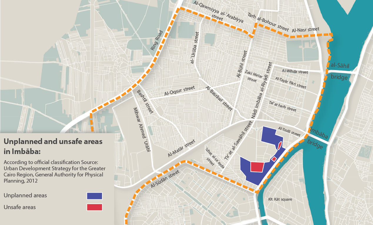
A map created by the General Authority for Physical Planning in 2012, shows details of areas within Imbaba which were unplanned, and that at the time, were considered unsafe. Imbaba is densely populated.[7][1]

Pigeon breeding is a favorite activity of some of the neighborhood residents with access to rooftops.[8][9]

Battle of the Pyramids

[edit]

The Battle of the Pyramids, also known as the Battle of Embabeh, was a battle fought on July 21, 1798, between the French army in Egypt under Napoleon Bonaparte, and local Mamluk forces. It occurred during France's Egyptian Campaign and was the battle where Napoleon put into use one of his significant contributions to tactics, the massive divisional square. Napoleon named the battle after the Egyptian pyramids, although they were only faintly visible on the horizon when the battle took place.

Siege of Imbaba

[edit]

In late 1992, the "Islamic Group" (al-Gama'a al-Islamiyya) expanded its influence in parts of Imbaba. In November, the group purportedly announced the establishment of the "Emirate of Imbaba" (some accounts claim that foreign news media coined the term, not the group itself). This challenge to the sovereignty of the Egyptian state triggered the siege of Imbaba, beginning on December 8. In its course, the government deployed over 12,000 police and state Security forces, along with one hundred personnel carriers and bulldozers, all of which put an end to the Emirate.[10][11][12]

Imbaba's districts

[edit]
  • Madinat Al-Umal
  • Bashtil
  • Madinat Al-Tahrir
  • Al-Muniera
  • Ard Al-Gameya

Notable people

[edit]

See also

[edit]

References

[edit]
[edit]
Revisions and contributorsEdit on WikipediaRead on Wikipedia
from Grokipedia
Imbaba (Arabic: إمبابة) is a densely populated urban district in northern Giza Governorate, Egypt, situated on the western bank of the Nile River opposite central Cairo and forming part of the Greater Cairo metropolitan area. It encompasses approximately 11 square kilometers and is characterized by a high concentration of working-class residents, informal housing developments, and ongoing urban challenges associated with rapid growth.[1][2] Historically, the area gained prominence as the site of the Battle of Embabeh in July 1798, where French forces under Napoleon Bonaparte decisively defeated the Mamluk cavalry, marking a key early victory in the French campaign in Egypt and paving the way for the Battle of the Pyramids.[1][3] The district also served as the location of Imbaba Airport, a former airfield that operated until recent decades and has since been slated for closure to facilitate redevelopment.[4] In contemporary times, Imbaba is the focus of urban upgrading projects led by the Giza Governorate, which aim to transform the decommissioned airport grounds and surrounding areas into integrated public spaces, housing, and commercial hubs to address overcrowding and infrastructure deficits. With an estimated population of 682,349 as of 2023—reflecting steady growth from prior census figures—the district exemplifies Egypt's broader patterns of peri-urban expansion and informal settlement dynamics.[5][2]

Etymology and Naming

Origins of the Name

The etymology of Imbaba remains uncertain, with historical records providing limited clarity on its precise origins. Medieval Egyptian chronicler Taqī al-Dīn al-Makrīzī (1364–1442), in his topographical works on Cairo and its environs, reportedly referenced an earlier form "Nabāba," from which "Imbāba" may derive through phonetic distortion over time.[1] Alternative explanations link the name to regional flora or migrant influences. Local traditions associate it with the Amharic term zembaba (ዘምባባ), signifying the doum palm (Hyphaene thebaica), a tree historically prevalent along the Nile in the area; this theory posits naming by Ethiopian or southern African arrivals, possibly reflecting the landscape's palm groves during early settlement.[1] No primary linguistic evidence confirms a direct Arabic root, though speculative ties to terms like bāb (gate) appear in some surname analyses without broader attestation for the place name.[6]

Historical Linguistic Evolution

The toponym Imbāba (Arabic: إمبابة), denoting the district in northern Giza, Egypt, exhibits limited documented linguistic evolution, with primary historical attestation emerging in medieval Arabic sources. Egyptian historian Taqī al-Dīn al-Makrīzī (1364–1442), in his topographic compendium Al-Mawāʿiẓ wa-al-Iʿtibār fī Dhikr al-Khiṭaṭ wa-al-Āthār, referred to the area as Nabāba, a form posited by subsequent scholars as the phonetic precursor to Imbāba through gradual distortion in vernacular pronunciation and orthography during the Mamluk era (1250–1517). This shift likely reflects natural Arabic dialectal variations, where initial n- elision or assimilation to i- could occur in regional speech patterns, though direct manuscript evidence for intermediate forms remains scarce.[7] Earlier origins remain speculative, lacking attestation in ancient Egyptian hieroglyphic, Demotic, or Coptic records specific to the locale. Proposed Afroasiatic roots, such as derivations from Ethiopian Semitic languages—including Amharic zembaba (ዘምባባ) for the African fan palm (Borassus aethiopum), potentially alluding to prehistoric Nile floodplain vegetation—appear in folk etymologies but lack corroboration from archaeological or paleobotanical data tying them to the site's nomenclature. Similarly, phonetic parallels in Tigre and Tigrinya (Embaba) suggest possible migratory linguistic influences from the Horn of Africa, yet these hypotheses rely on modern linguistic comparison rather than historical texts. By the late 18th century, European accounts of the Battle of the Pyramids (July 21, 1798) consistently render the name as Embabeh or Imbaba, indicating stabilization in its Arabic form amid Ottoman-era usage.[8] The persistence of Imbāba into the modern era aligns with broader patterns of toponymic conservation in Egyptian Arabic, minimally altered by 19th- and 20th-century urbanization despite phonological pressures from Cairene dialects. No significant orthographic reforms or renamings are recorded post-Makrīzī, underscoring the name's resilience amid sociolinguistic shifts from classical to colloquial Arabic dominance in the region.

Geography and Demographics

Location and Physical Features

Imbaba is a district in Giza Governorate, Egypt, positioned on the western bank of the Nile River, opposite the Zamalek area of Cairo Governorate. It lies within the Greater Cairo metropolitan area, approximately 4-5 kilometers northwest of central Cairo's Tahrir Square, at coordinates 30°04′46″N 31°11′54″E.[9] The district borders the Nile to the east, with extensions westward encompassing urbanized zones that were historically agricultural lands along the floodplain. The physical landscape of Imbaba consists of flat alluvial terrain typical of the Nile Valley, with elevations ranging from about 20 to 30 meters above sea level, conducive to dense settlement but prone to urban heat island effects due to extensive built-up areas.[10] This low-lying plain features informal urban morphology, including high-density residential clusters, narrow streets, and limited green spaces, overlaid on the former Imbaba Airport site—a 1.2 square kilometer expanse now slated for redevelopment into mixed-use urban facilities.[5] Key physical infrastructure includes the Imbaba Bridge spanning the Nile, facilitating connectivity to eastern Cairo, and proximity to Nile branches and irrigation canals that historically supported agriculture before urbanization intensified post-mid-20th century.[1] Imbaba's population has exhibited steady growth over recent decades, driven primarily by rural-to-urban migration within Egypt and sustained natural increase. Official statistics from the Central Agency for Public Mobilization and Statistics (CAPMAS) record the population of Imbaba kism at 523,265 in the 1996 census, rising to 598,882 in 2006 and 632,599 in the 2017 census.[2] An estimate for 2023 places it at 682,349, reflecting an annual growth rate of 1.2% between 2017 and 2023.[2]
Census YearPopulation
1996523,265
2006598,882
2017632,599
This table compiles CAPMAS census data for Imbaba kism, illustrating a cumulative increase of approximately 21% from 1996 to 2017.[2] Growth has been uneven, with higher rates in earlier periods linked to industrialization and informal settlement expansion in Greater Cairo, though official figures may underrepresent transient populations in unregulated areas.[2] Population density in Imbaba remains among the highest in Egypt's urban centers, calculated at 61,975 inhabitants per square kilometer in 2023 based on an administrative area of 11.01 km².[2] Geospatial estimates from sources like the Global Human Settlement Layer, which incorporate satellite-derived built-up areas, suggest denser concentrations, reaching 89,431 per km² in 2015 over a smaller assessed area of 8.4 km², potentially including adjacent informal expansions not fully captured in administrative boundaries.[11] Such discrepancies highlight challenges in delineating Imbaba's effective urban footprint amid ongoing informal development. Natural increase has contributed significantly, with Imbaba recording elevated fertility rates—around 23,000 annual births as of 2008—exceeding national averages and fueling density pressures.[12] Urban upgrading initiatives since the 1990s have aimed to mitigate overcrowding, but density trends continue upward due to limited outward expansion constrained by Nile proximity and infrastructure.[2]

Historical Development

Pre-Modern and Early Modern Period

Imbaba, documented in medieval sources as Nabāba, emerged as a rural settlement on the Nile's western bank, first referenced by the 15th-century historian Taqī al-Dīn al-Makrīzī in his topographical compendium Al-Mawāʿiẓ wa-l-iʿtibār bi-dhikr al-khiṭaṭ wa-l-āthār.[1] The name likely evolved from terms linked to the doum palm (Hyphaene thebaica), evoking its position along the Darb al-Arbaʿīn caravan route, which facilitated trade from sub-Saharan Africa.[1] In the Mamluk era (1250–1517), Imbaba consisted of scattered agricultural hamlets, such as Kafr al-Sheikh Ismaīl, sustained by Nile-irrigated fields and proximity to Cairo's western periphery.[1] Its Friday market drew long-distance camel traders from Sudan and the Horn of Africa, establishing it as a commercial node for livestock exchange that endured across centuries.[1] Under Ottoman rule (1517–1798), Imbaba retained its agrarian character within Egypt's beylik system, where Mamluk beys held de facto control despite nominal suzerainty from Istanbul.[13] The village's landscape of clover fields and sand hills supported modest farming and pastoral activities, with religious sites like the mosque and dargah of Sufi sheikh Ismaīl al-Imbābī highlighting localized devotional networks.[1] Periodic Nile floods and caravan traffic shaped its economy, though broader Ottoman administrative neglect of rural peripheries limited infrastructural growth.[14]

19th-Century Events and Growth

During the early 19th century, Imbaba functioned primarily as a rural agricultural village along the Nile, supporting local farming and serving as a key node in regional trade networks. It hosted a prominent camel market, Africa's largest, where caravans along the Darb al-Arba‘īn route brought livestock from Sudan and the Horn of Africa for sale on Fridays, sustaining economic activity amid Egypt's broader modernization under Muhammad Ali Pasha (r. 1805–1848).[15][1] This market, drawing on centuries-old overland commerce, integrated Imbaba into trans-Saharan exchanges, though the area remained clustered around villages like Kafr al-Shaykh Isma‘il with limited urban features.[1] Growth accelerated in the late 19th century with infrastructure projects that enhanced connectivity to Cairo and Giza. Construction of the Old Imbaba railway bridge began in 1890, spanning approximately 495 meters across the Nile with six fixed sections and one movable pivot section (21.5 meters wide) to accommodate river traffic, alongside a single rail track and pedestrian/vehicular paths.[16] Designed to link Giza station to Upper Egypt lines, the bridge—opened in 1892 under Khedive Abbas II—facilitated expanded rail and road traffic, boosting westward transport and marking Imbaba's emergence as a linked settlement rather than an isolated rural outpost.[16][1] By the century's close, these developments transformed Imbaba from a cluster of agrarian hamlets into a small town featuring shops, services, and increased prominence tied to the namesake railway bridge, laying groundwork for further urbanization while retaining its trade and agricultural base.[1] The bridge's role in Egypt's railway expansion exemplified khedival-era engineering, directly contributing to local economic integration without displacing core rural functions.[16]

20th-Century Urbanization

Imbaba's urbanization gained momentum in the early 20th century through infrastructural developments that integrated it with Cairo. The construction of a railway bridge in 1890 improved connectivity across the Nile, followed by a new road bridge in 1925, which facilitated the influx of workers and commerce.[1] Industrial establishments emerged in the 1930s, including the Anglo-Egyptian Motors factory in 1937 and the Chourbagui Textile Factory in 1940, drawing labor from rural areas and spurring residential expansion.[1] Mid-century shifts marked a transition to predominantly informal growth amid Egypt's broader rural-urban migration. Planned laborers' housing began in the 1920s, with 1,106 units completed by 1950, and further developments like Madinat al-Taḥrīr between 1954 and 1958; however, these were insufficient for the surging population, leading to unauthorized settlements from the 1940s onward, particularly from Upper Egyptian migrants in areas like Izbat al-Ṣaāyda.[1] [17] The establishment of Imbaba Airport in the 1940s initially surrounded by fields further enabled peri-urban sprawl, as agricultural land converted to haphazard housing to accommodate Cairo's demographic pressures.[1] By the late 20th century, Imbaba exemplified Cairo's informal urbanization patterns, with spontaneous construction overwhelming planned efforts due to rapid population influx and limited formal housing supply. Informal areas proliferated in the 1950s and expanded significantly by the 1980s, coinciding with the ring road's construction, which enhanced accessibility but exacerbated overload on existing structures.[1] [18] This growth reflected Egypt's national trend, where Greater Cairo's population rose from approximately 10 million in the early 20th century to over 10 million by 1970, driven by high fertility and migration rather than industrial formalization alone.[19] Government responses remained reactive, prioritizing containment over comprehensive planning, as informal development accommodated the majority of urban expansion in districts like Imbaba.[20]

Key Historical Events

Battle of the Pyramids (1798)

The Battle of the Pyramids, also known as the Battle of Embabeh, occurred on July 21, 1798, at the village of Embabeh (modern Imbaba), situated on the west bank of the Nile River approximately 15 kilometers northwest of the Giza pyramids, contrary to the battle's propagandistic name chosen by Napoleon Bonaparte.[21][22] The engagement marked a pivotal clash during the French invasion of Egypt, where Bonaparte's Army of the Orient, advancing inland from Alexandria after landing on July 1, confronted Mamluk forces entrenched at Imbaba to defend Cairo.[23][21] French troops, totaling around 25,000 men organized into four divisions under generals like Jean Reynier and Louis Bonaparte, marched through the desert under harsh conditions, suffering from thirst and heat exhaustion en route.[21] The opposing Mamluk army, commanded primarily by Murad Bey with Ibrahim Bey overseeing a secondary force nearer Cairo, comprised an estimated 40,000 combatants, including 4,000–6,000 elite Mamluk cavalry, 15,000 irregular fellaheen infantry, Arabian horsemen, and a contingent of Albanian Janissaries or Ottoman auxiliaries, supported by 40 cannons.[23][21][22] The Mamluks fortified Imbaba with earthworks and positioned their cavalry for shock charges, relying on traditional tactics ill-suited against disciplined European infantry.[21] Combat commenced around 3 p.m. and lasted 1–2 hours, with the French forming hollow infantry squares—each side 500–600 meters long, with artillery batteries at the corners—to repel repeated Mamluk cavalry assaults.[23][21] French volleys and grapeshot inflicted heavy losses on the charging horsemen, who broke against the unyielding formations; simultaneous advances by French divisions assaulted the Imbaba entrenchments, cutting off Mamluk retreats across the Nile and forcing many to drown while fleeing.[21] Casualties reflected the tactical mismatch: French losses were light at approximately 29 killed and 120–260 wounded, while Mamluk dead numbered 2,000–10,000 (including up to 7,000 elite warriors), with thousands more irregulars killed or drowned and 40 guns captured.[23][21][22] The rout at Imbaba shattered Mamluk cohesion, enabling French occupation of Cairo by July 24 without further major resistance in Lower Egypt and signaling the effective collapse of Mamluk dominance in the region.[23][21] Murad Bey escaped southward, continuing guerrilla opposition, but the battle's success at this Nile-side village underscored Imbaba's role as a linchpin in Cairo's defenses.[22] Despite the victory, French strategic gains were short-lived, undermined by Admiral Horatio Nelson's destruction of the French fleet at the Battle of the Nile on August 1, stranding the expedition.[21]

Siege of Imbaba (1992)

The Siege of Imbaba, occurring from December 8 to 12, 1992, represented a major escalation in the Egyptian government's campaign against Islamist militants amid rising violence in the early 1990s. Imbaba, a densely populated informal settlement in Giza with approximately one million residents, had emerged as a stronghold for al-Gama'a al-Islamiyya (Islamic Group), a Sunni Islamist organization seeking to impose its interpretation of Islamic governance.[24] [25] The group had established parallel authority in the area, providing social services, collecting informal taxes, and enforcing strict social codes, which directly challenged state sovereignty and contributed to localized instability.[25] This development followed a pattern of Islamist expansion in neglected urban peripheries, where weak state presence allowed militants to fill governance vacuums, exacerbating tensions after earlier incidents like the 1991 killing of 13 Coptic Christians in Dayrout.[25] Egyptian security forces, under Interior Ministry direction, initiated the operation by surrounding Imbaba with an estimated 12,000 to 14,000 personnel, including police, Central Security Forces, and armored units equipped with automatic rifles and personnel carriers.[26] [27] The five-day cordon and search effort involved house-to-house raids targeting suspected militants, weapons caches, and safe houses, marking the largest such deployment in Cairo at the time.[26] Officials justified the action as necessary to dismantle the militants' operational base, following intelligence on planned attacks and the group's role in over 70 deaths nationwide that year from related violence.[28] The operation resulted in over 600 arrests of suspected al-Gama'a al-Islamiyya members, including key figures like Sheikh Gaber, with authorities seizing ammunition, propaganda materials, and makeshift explosives.[29] Resistance was limited, with no confirmed large-scale clashes or significant casualties reported during the Imbaba sweeps themselves, though separate contemporaneous raids elsewhere yielded a few militant deaths in shootouts.[30] Human Rights Watch documented credible accounts of abuses, including arbitrary detentions of non-combatants, beatings during interrogations, and instances of torture in post-raid custody, highlighting systemic issues in security operations against perceived threats.[24] In the broader context, the siege signaled a shift toward aggressive state reclamation of informal areas, prioritizing reassertion of control over impoverished districts where Islamist influence thrived due to socioeconomic neglect rather than purely ideological appeal.[25] It preceded intensified counter-insurgency measures, including military trials and executions of militants, but also drew criticism for exacerbating community grievances without addressing underlying poverty and infrastructure deficits in Imbaba.[24] While effective in disrupting local militant networks, the event underscored causal links between state neglect, Islamist opportunism, and cycles of repression, influencing Egypt's security doctrine amid ongoing unrest that claimed hundreds of lives by mid-1993.[24]

Administrative Divisions

Main Districts and Sub-Areas

Imbaba, as a kism (police district) in Giza Governorate, encompasses a patchwork of informal settlements, planned housing enclaves, and older quarters, many of which developed organically through rural-to-urban migration and industrial expansion post-World War II. These sub-areas vary in density and infrastructure, with populations exceeding 600,000 across the kism as of the 2023 census estimate.[31] A key sub-area is Madinat al-Umal (City of Workers), established in 1947 as one of Egypt's earliest organized public housing initiatives to accommodate factory laborers near Cairo's expanding industries. This planned residential zone contrasts with surrounding informal expansions, featuring multi-story blocks designed for affordability amid post-war labor demands.[32] Bashtil (also spelled Bashteel) forms another central quarter, characterized by narrow streets, commercial activity, and historical ties to agricultural villages absorbed into urban sprawl. It gained prominence with the 2024 inauguration of Bashteel Railway Station, a major hub linking Imbaba to Upper Egypt, Alexandria, and other lines, designed to handle 250,000 daily passengers and alleviate congestion in northern Giza.[33][34] Kawmeya, an informal sub-neighborhood within Imbaba's southern extents, exemplifies the area's ashwa'iyyat (unplanned) character, with high-rise informal constructions housing low-income families amid limited services. Targeted in urban upgrading efforts since the 2010s, it highlights Imbaba's integration challenges, bordering formal zones while facing chronic overcrowding at densities rivaling global extremes.[35] Adjacent to these, sub-areas like Mit Uqba and Ard Liwaa intersect at transport nodes, contributing to Imbaba's mosaic of mixed-use pockets where residential, commercial, and light industrial functions overlap without rigid boundaries.[33] Overall, these divisions reflect Imbaba's evolution from peripheral farmland to a congested urban node, with administrative oversight fragmented across shiakhas (census blocks) under the North Giza district.[17]

Governance and Local Administration

Imbaba falls under the administrative jurisdiction of Giza Governorate, specifically within the North Giza Administrative District, which oversees its urban neighborhoods and informal settlements spanning approximately 8.28 square kilometers.[1] The area is subdivided into two main sections: the first comprising 11 zones including Mīt Kardak and Gizīrat Imbaba, and the second with 7 zones such as Qiblī Thānī and Masaken al-Maṭār.[1] District-level administration is managed from an office in al-Agouza, outside Imbaba, leading to challenges in responsive governance for local services like waste management and sewage, as the expansive scope dilutes direct oversight.[1] [35] Local administration operates through the Ministry of Local Development's framework, with Imbaba integrated into broader governorate-led initiatives rather than autonomous municipal councils.[31] In 2015, the Giza Governorate established a specialized unit for the North Giza Sector Urban Upgrading Project to address infrastructure deficits, coordinating with central agencies including the General Organization for Physical Planning and the Central Agency for Reconstruction, Public Housing and Urban Development.[1] This structure reflects Egypt's tiered system of governorates, districts, and zones, where informal areas like much of Imbaba—classified as mintaqa 'ashwa'iyya (unplanned zones)—receive services via ad hoc projects rather than formalized local units.[36] Residents have voiced concerns over corruption and unaccountability in district administration, prompting informal committees such as the People’s Committee for Defending the Revolution to represent community interests in disputes over land and development.[1]

Socio-Economic Conditions

Economy and Informal Employment

The economy of Imbaba is predominantly informal, mirroring national trends in Egypt where informal employment accounted for 66.7% of total employment in 2020.[37] In this densely populated district of Giza Governorate, with an estimated 750,000 to 1 million residents, most economic activities occur outside formal regulatory frameworks, driven by limited access to capital, skills mismatches, and rapid urbanization.[38] Informal workers engage in low-barrier livelihoods such as street vending, small-scale repair services, and household-based production, which sustain households amid high underemployment despite Egypt's overall unemployment rate falling to 6.4% in Q4 2024.[39] Key sectors include micro-manufacturing clusters, notably informal plastic processing and carpentry workshops, which operate in residential spaces and alleys, often employing family members or casual labor.[40] Transportation services, particularly tuk-tuk operations, provide flexible income, with drivers in adjacent informal areas earning 10–15 Egyptian pounds per hour during peak periods as of the early 2010s.[38] Waste recycling and sorting also feature prominently, leveraging Imbaba's proximity to urban waste streams for manual collection and resale, though these activities yield precarious earnings vulnerable to market fluctuations and eviction risks.[41] Such informal enterprises contribute to local resilience but limit productivity, as they evade taxes and formal credit, perpetuating cycles of low investment and skill stagnation.[42] Government upgrading initiatives, including street widening by 2012 to facilitate small business expansion, aim to integrate informal activities into semi-formal structures, yet progress has been uneven, with informal employment remaining entrenched due to structural barriers like tenure insecurity.[38] In Imbaba, where informal labor concentrations mirror broader Cairo patterns, these dynamics underscore a reliance on networks of kin and community for job access rather than institutional channels.[43]

Poverty, Housing, and Infrastructure Deficits

Imbaba exemplifies the socio-economic challenges of Cairo's informal settlements, where a significant portion of residents live below Egypt's national poverty line, estimated at around 30-35% for urban areas in recent years, with informal employment and low wages perpetuating vulnerability.[44] [45] Many households rely on daily labor in nearby markets or construction, facing irregular income amid rising living costs, as evidenced by anecdotal reports of child vendors and school dropouts in the district.[46] These conditions reflect broader patterns in unplanned urban zones, where poverty correlates with limited access to formal services and high population pressures from rural migration.[47] Housing in Imbaba predominantly features self-built, multi-story structures erected without official permits on agricultural or marginal land, resulting in substandard construction prone to hazards like collapses, as seen in incidents displacing dozens of families in 2015.[48] These dwellings often lack proper ventilation, sanitation within units, and seismic reinforcements, with densities reaching extreme levels—over 100,000 inhabitants per square kilometer in core areas—fostering overcrowding and tenure insecurity.[49] [50] Informal expansion since the mid-20th century has prioritized affordability over durability, leaving residents exposed to eviction risks during state clearance efforts.[51] Infrastructure shortfalls compound these issues, with drinking water networks suffering intermittent supply and contamination risks due to outdated piping, while sewage systems rely on inadequate, often open channels prone to overflow during floods.[35] [38] Electricity access, though widespread via illegal hookups, leads to frequent outages and fire hazards from overloaded lines; solid waste collection lags, contributing to environmental degradation and health concerns like disease spread.[38] Narrow, unpaved alleys impede vehicle access for maintenance or emergencies, and stormwater drainage is minimal, exacerbating annual inundations.[35] Government upgrading initiatives, such as the Imbaba Urban Upgrading Project launched in the 2000s, have targeted these gaps by extending utilities and paving roads, yet coverage remains uneven, with deteriorating conditions persisting in peripheral zones.[5]

Crime Rates and Security Challenges

Imbaba, characterized by high poverty and dense informal settlements, faces elevated risks of petty theft, burglary, and drug-related offenses compared to more affluent areas of Greater Cairo. A 2015 study on urban design and crime in Greater Cairo found that while official reported crime rates show a negative correlation with the proportion of informal areas (coefficient -0.3546), underreporting is likely prevalent in such neighborhoods due to distrust in authorities and reliance on informal dispute resolution.[52] Egypt's national theft rate stood at 104 incidents per 100,000 people in 2011, with urban centers like Giza exhibiting higher property crime concerns, including vandalism and break-ins, rated as moderate (47.28 on Numbeo indices).[53] [54] These issues in Imbaba are exacerbated by economic desperation, where informal employment fails to meet basic needs, driving residents toward survival crimes. Drug addiction and trafficking constitute a major security challenge, with Imbaba hosting significant rehabilitation efforts indicative of widespread prevalence. The World Health Organization praised Egypt's model, highlighting the Azima Center in Imbaba as a benchmark facility for treating substance abuse, amid regional concerns over synthetic drugs like Shabu fueling violent incidents and family disruptions.[55] Reports note that narcotics distribution networks exploit the area's labyrinthine alleys, contributing to related violence, though official data underemphasizes this due to focused counter-narcotics raids elsewhere.[56] Police responses often prioritize confrontation over prevention, with historical patterns of excessive force in Imbaba leading to civilian casualties and eroded community trust.[36] Sectarian tensions have periodically escalated insecurity, as seen in the May 2011 clashes between Muslim and Christian residents, which killed at least 12 and injured over 200, triggered by rumors of forced conversions and church construction disputes.[57] Such events underscore vulnerabilities in mixed communities, where weak state presence allows rapid mobilization of mobs, though post-2013 security crackdowns have reduced overt Islamist-linked violence. Overall, Imbaba's challenges reflect broader causal links between unchecked urbanization, unemployment, and crime, with governance deficits hindering effective policing without alienating locals.[58]

Urban Development and Infrastructure

Former Imbaba Airport Redevelopment

Imbaba Airport, originally established as a pilot training facility in the Giza suburb of Cairo, ceased operations in 2002 primarily due to safety risks posed by encroaching urban buildings that compromised flight paths and runway integrity.[59][60] The site's subsequent disuse for over a decade prompted the Giza Governorate to integrate its redevelopment into the Imbaba Urban Upgrading Project, launched in the early 2010s to address informal settlement challenges and convert the former airfield into a mixed-use urban hub.[5][61] Spanning approximately 70 hectares and impacting around 50,000 residents, the project focuses on infrastructure enhancements, including the creation of two public service centers, expanded green spaces for recreation, and zones for employment-generating activities.[35][62] The master plan allocates 52.4 acres for residential development and 38 acres for a safari-themed park known as Imbaba Airport Park, alongside provisions for commercial and investment areas to stimulate local economic activity.[63] Specific components encompass 3,100 modern residential units and 222 commercial shops to provide diverse services and housing upgrades.[64] Progress has advanced through phased implementations, with early efforts in the 2010s emphasizing park development and basic urban renewal, evolving into comprehensive building renovations and utility improvements by the mid-2020s.[61] In May 2025, Egyptian Prime Minister Mostafa Madbouly convened a review meeting, confirming completion of drainage, water testing, and defect repairs in over 100 associated buildings—representing 85.5% of targeted renovations—and directing accelerated timelines for full integration with surrounding areas like Aziz Ezzat.[65] These measures aim to mitigate longstanding deficits in housing quality, sanitation, and public amenities while prioritizing resident relocation and economic inclusion.[66]

Recent Government Projects (Post-2010)

In 2013, the Egyptian Ministry of Housing announced several development initiatives in Imbaba as part of broader urban renewal efforts on former airport land, including a 28-acre countryside-themed park constructed at a cost of LE 90 million (approximately $13 million at the time). The park features agricultural elements such as fruit trees, a pond, stream, water wheel, pigeon towers, an amphitheater, restaurant, cafeteria, shops, and a multi-purpose hall, with completion expected by late 2013 to provide recreational space for residents.[61] Concurrent with the park, the government extended Ahmed Oraby Avenue from Mohandessin to the Ring Road, crossing the railroad, at a cost of LE 500 million (approximately $72 million), with the project nearing completion by October 2013 to improve connectivity and reduce traffic congestion in the district.[61] Adjacent to the park, a housing development on 40-50 acres between the park and Ring Road added approximately 3,500 residential flats in uniform blocks, aimed at addressing housing shortages but criticized for lacking integrated urban design.[61] Plans also included new schools and a 200-bed hospital to serve Imbaba's population, though implementation timelines post-2013 remain limited in public records.[61] The Imbaba Urban Upgrading Project, led by Giza Governorate with Union for the Mediterranean endorsement, sought to enhance urban facilities, generate employment, and foster revenue activities while integrating Imbaba and Al-Warraq with greater Cairo, targeting over 2 million residents; initiated in the early 2010s, it complemented airport site redevelopment by focusing on infrastructure and economic opportunities.[5] As part of Nile Riverfront enhancements, the "Mamsha Ahl Masr" (Walkway for the People of Egypt) project developed a promenade from the May 15 Bridge to Imbaba Bridge, incorporating parks along the Nile banks, removal of encroachments, and tourism facilities, with Prime Minister inspections in January 2020 confirming progress toward improved public access and green spaces.[67][68] The historic Imbaba Bridge, spanning the Nile as Cairo's sole railway crossing, underwent rehabilitation by the General Authority for Roads, Bridges and Land Transport at a cost of 40 million Egyptian pounds to restore structural integrity and support ongoing urban mobility.[69] These initiatives reflect targeted post-2010 government investments in infrastructure amid Imbaba's dense informal settlements, though evaluations note uneven progress in service delivery and resident relocation impacts.[70]

Controversies and Social Dynamics

Islamist Radicalization and Militant Networks

In the early 1990s, Imbaba emerged as a significant base for Islamist militants amid Egypt's broader insurgency led by groups such as al-Gama'a al-Islamiyya, which sought to overthrow the secular government through violence targeting officials, Coptic Christians, and secular institutions.[24] The district's informal settlements, characterized by dense populations exceeding one million residents and minimal state presence, provided fertile ground for radical networks to organize, enforce parallel governance, and recruit from disenfranchised youth via informal social and economic ties.[43][71] Local leader Sheikh Gaber Abu Ali established dominance in Imbaba during the late 1980s, creating what authorities described as an "Islamic republic" by imposing strict moral codes, collecting protection taxes, and clashing with mainstream Muslim Brotherhood elements to consolidate power.[72] His network, comprising hundreds of armed followers, operated hideouts for planning attacks, including bombings against video shops deemed un-Islamic, which prompted reprisal violence in late 1992.[28] These militants exploited the area's poverty and infrastructure neglect to blend into communities, using mosques and alleyways for logistics while propagating Salafi-jihadist ideologies that framed state neglect as justification for takfir (declaring apostasy) against the regime.[73] The peak of militant entrenchment culminated in a massive security sweep on December 8, 1992, when approximately 14,000 troops and police raided Imbaba, arresting over 600 suspects in clashes that killed or wounded dozens, including efforts to capture Sheikh Gaber, though initial operations failed to apprehend the network's head.[74][75] The three-week operation dismantled key strongholds, seizing weapons and propaganda materials, but highlighted how radicalization thrived on state absence rather than direct ideological import, with militants adapting rural Islamist norms to urban informality for sustenance and control.[76] Post-crackdown, Imbaba's networks fragmented, contributing to al-Gama'a al-Islamiyya's shift toward Upper Egypt, though residual sympathies persisted in the district's underclass.[77]

State Security Responses and Police Actions

In December 1992, Egyptian security forces initiated a large-scale operation in Imbaba targeting the Gama'a al-Islamiyya, an Islamist militant group that had declared the neighborhood an autonomous "Islamic emirate" and provided parallel social services to undermine state authority.[26] Approximately 12,000 to 14,000 troops conducted house-to-house searches starting on December 8, resulting in the arrest of between 290 and 700 suspected militants, including the local "emir" of the group.[75] [78] [29] Authorities described the weeks-long sweep as a success in dismantling militant infrastructure and restoring control, though human rights monitors, including the Egyptian Organization for Human Rights, reported widespread arbitrary detentions, beatings, and property damage during the raids.[24] Subsequent police actions included targeted raids against affiliated networks. In March 2001, security forces arrested 25 members of the banned Muslim Brotherhood during a operation in Imbaba, reflecting ongoing efforts to suppress Islamist organizing in the district.[79] These measures operated under Egypt's long-standing emergency law, which granted security personnel broad powers and limited accountability, contributing to patterns of impunity documented in the area.[36] A notable instance of contested response occurred on May 7, 2011, amid sectarian clashes in Imbaba triggered by Salafist protests against alleged illegal church construction. Islamist mobs burned St. Mina's Church and another site, killing 12 people—mostly Coptic Christians—and injuring over 200, with security forces arriving hours later despite proximity.[80] [81] Critics, including Human Rights Watch and the Egyptian Initiative for Personal Rights, faulted the police for inaction that enabled the violence, after which the army imposed a curfew but made few immediate arrests of perpetrators.[82] [83] This event underscored persistent challenges in countering radical mobilization in informal settlements like Imbaba, where delayed interventions allowed escalation.[84]

Debates on Informal Settlements and Criminalization

The Egyptian government's classification of informal settlements, or ashwa'iyyat, including areas in Imbaba, as "unsafe" or hazardous has fueled debates over whether such labeling justifies securitized interventions or constitutes undue criminalization of impoverished communities. Under President Abdel Fattah el-Sisi's administration, policies aim to eradicate these settlements by 2030, portraying them as breeding grounds for extremism, terrorism, and urban disorder, with Imbaba cited as a historical example through the 1992 siege that militarized the district in response to perceived Islamist threats. [85] This framing, echoed in state media and security discourse, links informality to national security risks, enabling measures like forced evictions and demolitions under broader urban plans such as Cairo 2050, which prioritize central land for commercial and tourist development while relocating residents to peripheral sites. [85] [86] In Imbaba specifically, the North Giza Development Project, announced in December 2008 following the closure of Imbaba Airport, targeted evictions affecting an estimated 500,000 residents by 2007, with up to 1 million in the broader zone, justified as essential for safety and redevelopment without community consultation. [86] Proponents of these approaches argue that informal settlements' lack of formal governance fosters criminal networks and instability, as evidenced by higher incidences of unrest in districts like Imbaba during the 1990s, necessitating state reclamation to impose order and provide upgraded infrastructure. [85] However, empirical data from the Informal Settlements Development Facility (ISDF) indicates that over half of Greater Cairo's population resides in such areas, many comprising self-built housing by working-class families rather than organized crime hubs, challenging the narrative of inherent deviance. [86] Critics, including human rights organizations, contend that this securitization criminalizes poverty by stigmatizing residents as "manipulators" or transients, leading to rights abuses such as unannounced demolitions, excessive police force, and inadequate relocation—often to distant, underserviced areas like 6 October City, 45 km from Cairo, exacerbating economic displacement without addressing root causes like housing shortages. [86] The 2019 Construction Violations Reconciliation Law, legalizing some 8.2 million informal units, represents a partial shift toward upgrading, yet debates persist over its efficacy, as demolitions continue in "unsafe" zones, displacing thousands while ignoring residents' contributions as professionals and laborers. [85] Scholars argue that such policies serve political power consolidation, deepening urban inequalities rather than resolving causal factors like rapid migration and regulatory failures since the 1970s. [85] These tensions highlight a causal divide: while informality empirically correlates with elevated security challenges due to weak state presence, broad criminalization risks alienating communities capable of self-organization, as seen in Imbaba's historical resilience amid neglect. [86] Alternative proposals emphasize participatory upgrading, such as the Imbaba Urban Upgrading Project's focus on facilities and jobs, over eviction, to mitigate both hazards and stigmatization without endorsing unchecked illegality. [5]

Notable Individuals

Political and Activist Figures

Sheikh Jabir Mohammed Ali emerged as a prominent Islamist activist in Imbaba during the early 1990s, leading local Gama'a al-Islamiyya networks that effectively controlled parts of the neighborhood amid state withdrawal from informal areas.[25] In June 1992, he declared Imbaba an "Islamic Republic," inviting foreign journalists to a press conference where he mocked the Egyptian government's inability to enforce authority there, highlighting the militants' provision of social services like dispute resolution and aid to residents.[87] [88] This defiance prompted a massive security crackdown in December 1992, involving 12,000-14,000 troops who arrested over 5,000 suspects, including Jabir, dismantling the militant infrastructure but exposing underlying governance failures in the district.[43] [89] Post-2011 revolution, Khaled Atef, a lifelong Imbaba resident and lawyer, became a key figure in local activism through popular committees formed to fill security and service voids left by retreating police.[90] As president of the Imbaba committee, Atef organized residents for self-policing, infrastructure maintenance, and community mediation in the district's narrow alleys, emphasizing grassroots democracy over reliance on centralized state control amid ongoing instability.[91] His efforts reflected broader post-Mubarak trends in informal settlements, where activists like him advocated for bottom-up governance to address poverty and crime without Islamist dominance.[92] Imbaba's political representation at national levels remains limited, with no figures from the district achieving widespread prominence beyond local Islamist or revolutionary activism; parliamentary seats for the area, such as in Giza's constituencies, are often held by non-residents aligned with ruling coalitions rather than district natives.[93] This scarcity underscores the neighborhood's marginalization in formal politics, where influence derives more from informal networks than elected office.

Cultural and Other Prominent Residents

Ali El Haggar, born on April 4, 1954, in Imbaba, emerged as a prominent Egyptian singer, composer, and actor known for blending traditional Arabic music with modern elements in his compositions and performances.[94] His career spanned decades, including notable appearances at events like the Citadel Music Festival, where he showcased his vocal range and musical versatility.[95] Ahmed El Haggar, born in 1956 in Imbaba, was a renowned Egyptian composer and singer whose work contributed to the country's musical heritage until his death on January 4, 2022, at age 65 following a heart attack.[96] He specialized in composing for films and television, often drawing from popular Egyptian genres, and maintained a family legacy in music alongside relatives like his brother Ali.[97] Yehia Chahine, born July 28, 1917, in Imbaba, was an influential Egyptian actor and film producer active from the mid-20th century, appearing in numerous productions such as Salu Qalbi (1952) and Son of the Nile.[98] He earned a diploma in performing arts and built a career in theater and cinema until his death on March 18, 1994, representing an earlier generation of Imbaba's contributions to Egyptian entertainment.[99] Mohamed Henedi, born February 1, 1965, in Imbaba (also spelled Imbabah), rose to fame as a comedian and actor, starring in films like Ismailia Rayeh Gay (1997) and Hamam fi Amsterdam (1999), often portraying humorous, relatable characters reflective of working-class life.[100] Among other prominent residents, soccer players from Imbaba include Ismail Youssef, born June 28, 1964, in the district, who played as a defensive midfielder for Egypt's national team and clubs like Al Ahly, earning recognition for his tactical contributions over a professional career spanning the 1980s and 1990s.[101] His brother, Ibrahim Youssef, born January 1, 1959, in Imbaba, was a forward who competed for Al Ahly and the national side, scoring key goals before his death on July 10, 2013, at age 54.[102] These athletes highlight Imbaba's role in producing talent for Egypt's competitive football scene.

References

User Avatar
No comments yet.