
Community hub
Recent from talks
Contribute something
Nothing was collected or created yet.
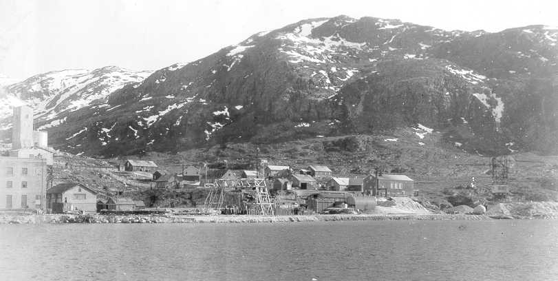
Ivittuut
View on WikipediaIvittuut (formerly, Ivigtût; Greenlandic for "Grassy Place")[1] is an abandoned mining town near Cape Desolation in southwestern Greenland, in the modern Sermersooq municipality on the ruins of the former Norse Middle Settlement.
Key Information


Ivittuut is one of the few places in the world so far discovered to have naturally occurring cryolite (Na3AlF6, sodium aluminum fluoride), an important agent in modern aluminum extraction.
History
[edit]| Part of a series on the |
| Norse colonization of North America |
|---|
 |

The area was settled by about twenty farms of Norsemen, a district called the "Middle Settlement" by modern archaeologists from its placement between the larger Western and Eastern Settlements. It is the smallest and least well known of the three, and no written records of its residents survive, for which reasons it is believed to have been established last (and abandoned first) of the three. Investigations show a presence after 985 and with occupation continuing up to at least the 14th century.[2]
The town's cryolite deposit was discovered in 1799,[3] and the veins of silver-bearing lead surrounding it were mined by the British engineer J.W. Tayler before the silver content was found to be too low to make the operation viable.[4] Danish engineers began mining the cryolite itself in 1859, and in 1864 the Danish Kriolit Mine og Handels Selskabet was granted a monopoly on its extraction.[4] These early mines simply processed the cryolite for its direct aluminum content and for sale to the Pennsylvania Salt Manufacturing Company, which used it to create caustic soda.
The 1884 establishment of the Hall-Heroult process, which depends on the rare cryolite but dramatically improved the extraction of aluminum from bauxite ore, increased the deposit's importance. The Ivittuut mining operations were a major factor in the American occupation of Greenland during World War II. The Kangilinnguit naval base was founded as Bluie West Seven ("Green Valley") by the United States Navy during the Second World War to protect the highly strategic cryolite quarry in Ivittuut.
After World War II, the cryolite was mined by the Danish firm Kryolitselskabet Øresund, which helped fund the establishment of Grønlandsfly, today's Air Greenland.
Cryolite was eventually synthesized, reducing the importance of the mine. The mine ran empty, but production was proceeded using earlier 'waste rock'. The mine was finally shut down in 1987.[5] The community was abandoned soon after.
In 1924, it was a stopping place for the first aerial circumnavigation, during which new engines were installed in two American biplane aircraft.[6]: 283
Climate
[edit]Ivittuut holds the record for Greenland's highest recorded temperature of 30.1 °C (86.2 °F), recorded on 23 June 1915.[7][8][9] The lowest recorded temperature was −28.9 °C (−20.0 °F) in February.[year needed]
Ivittuut has a tundra climate (ET) bordering on a subarctic climate (Dfc), with July having an average of 9.8 °C (49.6 °F). Summertime temperatures are cool with chilly nights, and wintertime temperatures are very cold with frigid nights.
| Climate data for Ivittuut | |||||||||||||
|---|---|---|---|---|---|---|---|---|---|---|---|---|---|
| Month | Jan | Feb | Mar | Apr | May | Jun | Jul | Aug | Sep | Oct | Nov | Dec | Year |
| Record high °C (°F) | 13.3 (55.9) |
14.4 (57.9) |
15.6 (60.1) |
16.1 (61.0) |
23.3 (73.9) |
30.1 (86.2) |
23.3 (73.9) |
21.7 (71.1) |
21.1 (70.0) |
19.4 (66.9) |
17.8 (64.0) |
15.6 (60.1) |
30.1 (86.2) |
| Mean daily maximum °C (°F) | −4.4 (24.1) |
−3.3 (26.1) |
−0.6 (30.9) |
3.3 (37.9) |
8.3 (46.9) |
12.2 (54.0) |
13.9 (57.0) |
12.8 (55.0) |
8.3 (46.9) |
4.4 (39.9) |
0.0 (32.0) |
−2.8 (27.0) |
4.3 (39.7) |
| Mean daily minimum °C (°F) | −11.1 (12.0) |
−11.1 (12.0) |
−8.9 (16.0) |
−4.4 (24.1) |
0.6 (33.1) |
3.9 (39.0) |
5.6 (42.1) |
5.0 (41.0) |
2.2 (36.0) |
−1.7 (28.9) |
−5.6 (21.9) |
−8.9 (16.0) |
−2.9 (26.8) |
| Record low °C (°F) | −27.8 (−18.0) |
−28.9 (−20.0) |
−27.2 (−17.0) |
−20.6 (−5.1) |
−10.6 (12.9) |
−2.2 (28.0) |
0.6 (33.1) |
−1.7 (28.9) |
−5.6 (21.9) |
−12.8 (9.0) |
−17.8 (0.0) |
−26.7 (−16.1) |
−28.9 (−20.0) |
| Average precipitation mm (inches) | 83.8 (3.30) |
66.0 (2.60) |
86.4 (3.40) |
63.5 (2.50) |
88.9 (3.50) |
81.3 (3.20) |
78.7 (3.10) |
94.0 (3.70) |
149.9 (5.90) |
144.8 (5.70) |
116.8 (4.60) |
78.7 (3.10) |
1,132.8 (44.6) |
| Source: Sistema de Clasificación Bioclimática Mundial[10] | |||||||||||||
Transport
[edit]Ivittuut and the Kangilinnguit military base are connected by a road, which is roughly 5 km (3 mi) long.
See also
[edit]References
[edit]- ^ "Sermersooq Municipality". Archived from the original on July 21, 2011.
- ^ Kevin J Edwards; Gordon T Cook; Georg Nyegaard; J Edward Schofield (2013-02-04). "Towards a First Chronology for the Middle Settlement of Norse Greenland". Radiocarbon. 55 (1). The University of Arizona Libraries: 13–29. doi:10.2458/azu_js_rc.v55i1.16395. S2CID 76651968. Retrieved March 25, 2016.
- ^ Mindat – the Mineral and Locality Database. "Cryolite". Accessed 5 May 2012.
- ^ a b Doody, Richard. The World at War. "GREENLAND 1721 - 1953". Accessed 28 Apr 2012. Archived January 4, 2012, at the Wayback Machine
- ^ arsukfjorden.gl Archived 2016-04-30 at the Wayback Machine. (in Danish)
- ^ Thomas, Lowell (1925). The First World Flight. Boston & New York: Houghton Mifflin Company.
- ^ "meteorologyclimate.com". Archived from the original on 2007-10-08. Retrieved 2008-12-17.
- ^ "Greenland -Dnk- - Ivigtut". Pendientedemigracion.ucm.es. Archived from the original on 26 January 2016. Retrieved 22 February 2019.
- ^ "More record lows since 1937 than record highs". Iceagenow.info. 27 June 2017. Archived from the original on 5 October 2018. Retrieved 22 February 2019.
- ^ "GREENLAND -DNK- - IVIGTUT". Centro de Investigaciones Fitosociológicas.
Abandoned sites in Greenland | ||||||||||||||
|---|---|---|---|---|---|---|---|---|---|---|---|---|---|---|
|
|  | ||||||||||||
|
| |||||||||||||
| ||||||||||||||
| ||||||||||||||
| Polar exploration | ||||||||||||||
| Paleo-Eskimo | ||||||||||||||
| International | |
|---|---|
| National | |
| Other | |
Ivittuut
View on GrokipediaGeography
Location and Administrative Status
Ivittuut is situated on the southwestern coast of Greenland, near Cape Desolation on the Arsuk Fjord.[8][2] The site is approximately 5 km south of Kangilinnguit, known historically as Grønnedal, a former Danish naval base, and lies about 380 km south of Nuuk, Greenland's capital.[9][10] In terms of governance, Ivittuut served as the center of Ivittuut Municipality from 1951 until Greenland's 2009 municipal reform, which reduced the number of municipalities from 18 to 4; following this, it was integrated into the larger Sermersooq Municipality.[2][11][12] The locality's name varies historically: Ivigtut in Danish and Ivittuut in Kalaallisut, the Greenlandic Inuit language.[2]Topography and Surrounding Environment
Ivittuut is situated on a low-lying peninsula along the western shore of Arsuk Fjord in southwestern Greenland, characterized by a hilly, glaciated terrain shaped by past Pleistocene ice ages. The landscape features undulating hills rising from sea level to elevations of approximately 50-100 meters, with rugged coastal cliffs and inland slopes marked by glacial erratics and U-shaped valleys typical of fjord regions. To the east, Arsuk Fjord extends about 32 kilometers inland, providing a sheltered waterway influenced by the nearby inland ice cap, which covers much of Greenland's interior and contributes to the area's cool, moist microclimate through calving glaciers and seasonal meltwater flows. The surrounding environment is dominated by barren rock outcrops and sparse tundra cover, with minimal soil development due to glacial scouring.[13][14] Geologically, the Ivittuut area forms part of the Precambrian shield of South Greenland, specifically within the Mesoproterozoic Gardar Province, a continental rift-related alkaline igneous complex dating to 1.35-1.14 billion years ago. The cryolite deposit occurs within a small leucogranite intrusion, approximately 300 meters across, surrounded by high-grade metamorphic granodioritic gneisses and intrusive breccias of the Ketilidian mobile belt. This alkaline affinity is evident in the igneous rocks, which facilitated the hydrothermal formation of the unique cryolite body through fluorine- and alkali-rich fluids. The broader Precambrian craton provides a stable, ancient basement, with the Gardar magmatism representing a key phase of rifting and alkaline volcanism in the region.[15][14][16] The natural surroundings exhibit limited biodiversity adapted to the harsh tundra conditions, with vegetation primarily consisting of mosses, lichens, and low-growing heaths that cover less than 20% of the ground in most areas. Mosses, including species like granite mosses and sphagnum, thrive in moist depressions, while lichens such as Cladonia and Umbilicaria dominate exposed rocks and heaths, serving as primary colonizers on barren substrates. Fauna is similarly sparse on land, featuring Arctic foxes (Vulpes lagopus) that roam the hills in search of lemmings and birds, as well as introduced muskoxen (Ovibos moschatus) translocated to the peninsula in 1987, though populations remain low due to the limited prey base and forage. Coastal waters of Arsuk Fjord support marine life, including ringed seals (Pusa hispida) and harbor seals (Phoca vitulina), which haul out on nearby shores. Since the town's abandonment in 1987, the absence of permanent human activity has allowed natural revegetation, though intermittent exploration activities have occurred as of 2025.[17][18][7]Climate
Climatic Classification
Ivittuut experiences a tundra climate classified under the Köppen system as ET, characterized by the warmest month having an average temperature below 10°C.[19] This classification reflects the region's polar location, where persistent cold limits vegetation to low-growing tundra species. The climate borders on subarctic influences, with occasional warmer spells that prevent a full transition to the Dfc category.[20] Seasonally, summers are cool, with July—the warmest month—averaging 9.8°C, while winters are harsh, featuring prolonged periods of subzero temperatures and frequent snow cover. The growing season is short, lasting approximately two months, during which limited daylight and cool conditions restrict plant growth primarily to mosses, lichens, and dwarf shrubs. These patterns underscore the tundra's marginal habitability, influencing brief periods suitable for outdoor activities or limited agriculture in southern Greenland.[19] The climate is shaped by several key factors, including proximity to the Atlantic Ocean, which brings relatively milder air masses to the southwestern coast compared to interior regions. Fjord systems, such as Arsuk Fjord, provide some moderation through sheltered conditions and occasional foehn winds that can temporarily raise temperatures. The nearby Greenland Ice Sheet contributes to precipitation patterns by generating katabatic winds and orographic effects, leading to higher snowfall in winter despite overall low annual totals.[21] Due to its high-latitude position, Ivittuut's weather exhibits significant variability, with abrupt shifts driven by North Atlantic Oscillation patterns that can alternate between mild, wet winters and colder, drier ones. This polar variability has historically challenged human settlement, contributing to the intermittency of Norse and later mining-era occupations.[21]Temperature and Precipitation Data
Ivittuut experiences a tundra climate characterized by cool summers and cold winters, with temperature data derived from long-term observations at the local weather station during the mining era (1873–1960). The annual average temperature is approximately -1°C, reflecting the influence of its coastal location and surrounding fjords.[21] The highest temperature ever recorded in Ivittuut—and indeed in Greenland—was 30.1°C, observed on June 23, 1915. Conversely, the lowest temperature reached -28.9°C in February, highlighting the potential for extreme cold during winter months. Monthly temperature variations show January as the coldest month, with an average low of -6.5°C, while July represents the warmest, featuring an average high of 12.5°C. These records underscore the site's climatic variability within its broader tundra classification.[21][22] Precipitation in Ivittuut totals 1,132.8 mm annually, predominantly falling as snow in winter and rain during the summer months. October typically sees the highest monthly precipitation, contributing significantly to the wetter autumn season. These measurements, also from the mining-era weather station, indicate a relatively high moisture regime compared to inland Greenland areas.[21]| Metric | Value | Period/Notes |
|---|---|---|
| Annual Average Temperature | ~ -1°C | 1873–1960 |
| Record High Temperature | 30.1°C (June 23, 1915) | All-time Greenland record |
| Record Low Temperature | -28.9°C (February) | Historical extreme |
| January Average Low | -6.5°C | Monthly representative |
| July Average High | 12.5°C | Monthly representative |
| Annual Precipitation | 1,132.8 mm | Includes rain and snow equiv. |
| Peak Monthly Precipitation | October | Highest monthly total |