Hubbry Logo
Juniata RiverJuniata RiverMain
Open search
Juniata River
Community hub
Juniata River
logo
8 pages, 0 posts
0 subscribers
Be the first to start a discussion here.
Juniata River
Juniata River
from Wikipedia

Juniata River
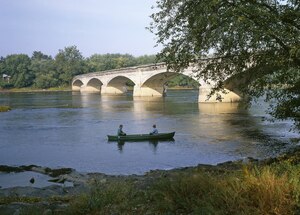
The Appalachian Trail crossing the mouth of the Juniata River. Photo by Carol M. Highsmith
Juniata River watershed and tributaries
Location
CountryUnited States
StatePennsylvania
CountiesDauphin, Perry, Juniata, Mifflin, Huntingdon, Bedford, Somerset
CitiesDuncannon, Newport, Millerstown, Thompsontown, Port Royal, Mifflintown, Lewistown, Mount Union, Huntingdon
Physical characteristics
SourceFrankstown Branch
 • locationBlair County, Pennsylvania, US
2nd sourceLittle Juniata River
 • locationPennsylvania, US
Source confluence 
 • locationPetersburg, Pennsylvania, US
 • coordinates40°33′39″N 78°04′06″W / 40.56083°N 78.06833°W / 40.56083; -78.06833
 • elevation660 ft (200 m)
MouthSusquehanna River
 • location
Duncannon, Perry County, Dauphin County, Pennsylvania, US
 • coordinates
40°24′05″N 77°00′48″W / 40.40139°N 77.01333°W / 40.40139; -77.01333
 • elevation
330 ft (100 m)
Length104 mi (167 km)
Basin size3,400 sq mi (8,800 km2)
Discharge 
 • locationNewport
 • average4,476 cu ft/s (126.7 m3/s)
 • minimum636 cu ft/s (18.0 m3/s)
 • maximum209,000 cu ft/s (5,900 m3/s)
Discharge 
 • locationMapleton Depot
 • average2,724 cu ft/s (77.1 m3/s)
Basin features
Tributaries 
 • leftStanding Stone Creek, Kishacoquillas Creek
 • rightRaystown Branch, Aughwick Creek, Tuscarora Creek

The Juniata River (/ˌniˈætə/)[1] is an approximately 104 mi (167 km) long[2] tributary of the Susquehanna River in central Pennsylvania. The river is considered scenic along much of its route, having a broad and shallow course passing through several mountain ridges and steeply lined water gaps. It formed an early 18th-century frontier region in Pennsylvania and was the site of French-allied Native American attacks against English colonial settlements during the French and Indian War.

The watershed of the river encompasses an area of approximately 3,400 square miles (8,800 km2), approximately one-eighth of the drainage area of the Susquehanna. Approximately two-thirds of the watershed is forested. It is the second largest tributary of the Susquehanna after the West Branch Susquehanna.

Description

[edit]

The Juniata River forms in western Huntingdon County at the confluence of the Frankstown Branch and the Little Juniata River, between the boroughs of Alexandria and Petersburg.[3] The river flows southeast through Huntingdon and continues to the small village of Ardenheim, where the Raystown Branch, the longest of the Juniata's tributaries, enters from the southwest. The Juniata continues southeast, through a gap in the Jacks Mountain ridge. On the southeast side of the ridge it receives Aughwick Creek from the south, then flows northeast, along the eastern flank of the Jacks Mountain ridge to Lewistown, where it collects Kishacoquillas Creek and Jacks Creek. From Lewistown it flows southeast, in a winding course, receiving Tuscarora Creek from the south at the Port Royal river bridge and passing through a gap in the Tuscarora Mountain ridge. The Juniata River is joined by three creeks in Millerstown in northeast Perry County. It receives Cocolamus Creek .7 miles (1.1 km) southeast, Raccoon Creek .5 miles (0.80 km) southeast, and Wildcat Run 2.8 miles (4.5 km) southeast of Millerstown. The river also receives Buffalo Creek .9 miles (1.4 km) northwest of Newport. The Juniata River joins the Susquehanna River in Reed Township, Dauphin County immediately northwest of the Clarks Ferry Bridge. This is northeast of Duncannon and approximately 15 miles (24 km) northwest of Harrisburg.[4]

Along the river's banks there are many access areas maintained by the Pennsylvania Fish and Boat Commission, as well as informal access areas and campground river access. The Juniata River is a popular spot for swimming, fishing, and boating. It even used to be the host of the Juniata River Sojourn,[5] which was held annually from 2001 (when the river was named Pennsylvania River of the Year[6]) through 2015.

Etymology

[edit]

The word "Juniata" is thought to be a corruption of the Iroquoian word Onayutta, meaning "Standing Stone". There was a large standing stone where the town of Huntingdon now stands. It was reportedly 14.5 feet (4.4 m) tall and contained carvings recording the history of the local Juniata Tribe. It disappeared in 1754, when the tribe left; tradition says they took it with them. A second stone was raised by the new settlers but destroyed in 1897. A two-foot (0.6 m) fragment of the second stone sits in Juniata College's museum.[7]

History

[edit]

The first known inhabitants of the river valley were the Onojutta-Haga Indians. The valley was later inhabited by the Lenape until a treaty negotiated by William Penn opened the land to east of the Allegheny Ridge to white settlement. In 1755–1756, as a result of Lenape anger over loss of their lands, the white settlement in the valley suffered fierce raids and abductions from Lenape and Shawnee at Kittanning on the Allegheny River. Over 3,000 white settlers were killed in the raids. The burning of Fort Granville at present-day Lewistown in 1756 prompted Pennsylvania governor John Penn to launch a reprisal against the Lenape and Shawnee led by Lt. Col. John Armstrong, who burned Kittanning in September 1756.

During the 19th century, the river was paralleled by the Juniata Division Canal, part of the canal system of Pennsylvania and a rival to the Erie Canal. The state sold the canal to the Pennsylvania Railroad, which abandoned the canal in 1889 after severe flooding. Parts of the original locks from the canal, as well as remnants of a dam approximately 1 mile (2 km) south of Millerstown, are still visible today.

The river is a popular destination for recreational canoeing and fly fishing, in particular for smallmouth bass and channel catfish suited to the river's gentle course. The muskellunge was introduced as predatory sport fish and is now a prized catch. Attempts are underway by the state to reintroduce the once-prevalent American shad, which went into decline largely because of dams on the river. Walleye is another game fish prevalent in the Juniata River.

The National Book Award and Pulitzer prize-winning poet Galway Kinnell wrote of the river in a section of The Book of Nightmares (1971), entitled "Dear Stranger, Extant in Memory by the Blue Juniata" ("The Blue Juniata" was a well-known 19th-century parlor song).

The river cuts through several southwest-to-northeast ridges, largely of sandstone between limestone valley floors. Several of the river's tributaries, including Kishacoquillas Creek, are degraded by pollution, but the main stem of the river is considered fairly clean by regional standards. The only city in the watershed with ten thousand or more residents is Altoona. Steep slopes along much of the river's course have largely discouraged widespread development.

[edit]

See also

[edit]

References

[edit]

Bibliography

[edit]
[edit]
Revisions and contributorsEdit on WikipediaRead on Wikipedia
from Grokipedia
The Juniata River is a major tributary of the in south-central , approximately 104 miles (168 km) long, formed by the confluence of the Raystown Branch and Little Juniata River near in County, with headwaters on the at an elevation of approximately 2,000 to 2,400 feet. It drains a watershed of 3,404 square miles entirely within , encompassing parts of 9 counties including , , Centre, Fulton, , Mifflin, Juniata, , and Snyder. The river's basin features the Ridge and Valley Province of the , characterized by parallel ridges, deep valleys, and topography that contribute to its scenic gorges like Jacks Narrows and diverse aquatic habitats. Major tributaries include the Raystown Branch (the longest at over 100 miles), Frankstown Branch, Little Juniata River, Aughwick Creek, Kishacoquillas Creek, and Tuscarora Creek, which together form a network of more than 6,700 stream miles supporting a of about 304,750 as of 2020. Flow is regulated by Raystown Dam since 1973, providing flood control, hydroelectric power, and via , while the overall system experiences seasonal variations with average discharges of approximately 2,500 cubic feet per second (71 m³/s) at Lewistown. Historically, the Juniata served as a vital Native American trail and early European , later becoming central to the Main Line Canal system in the 19th century for transporting goods between and , with remnants preserved as a . Today, it is designated a National Recreation Trail and was named River of the Year in 2001, offering Class I-II paddling, for species like and , and across its 150-mile water trail, while conservation efforts focus on , habitat restoration, and addressing [nonpoint source pollution](/page/Nonpoint_source pollution) in the watershed.

Physical Characteristics

Course and Length

The Juniata River originates at the of its primary headwater tributaries, the Frankstown Branch and the Little Juniata River, near the community of in . From this point, the river begins its southeastward journey, carving through the and Ridge and Valley physiographic provinces of central . The of the Juniata River measures approximately 104 miles (167 km) in length, flowing generally eastward before turning southeast to its at the in Duncannon, Perry County. Along this course, it traverses diverse terrain, including broad valleys and narrow passages where it crosses prominent Appalachian ridges via notable water gaps, such as Jacks Narrows—formed between Tuscarora Mountain and Jacks Mountain—and the gap through Tuscarora Mountain itself. These features create dramatic, steep-sided channels that highlight the river's role in shaping the regional landscape. As it progresses, the river passes through several key communities that reflect its historical and cultural significance, including in Huntingdon County, Lewistown in Mifflin County, Mifflintown in Juniata County, and Newport in Perry County. The route is characterized by scenic forested valleys interspersed with rocky gorges, providing a mix of open farmlands and wooded slopes that enhance its appeal for navigation and observation. Tributaries intermittently join along the way, contributing to the river's volume without altering its primary southeastward trajectory.

Drainage Basin and Tributaries

The drainage basin of the Juniata River covers approximately 3,400 square miles (8,800 km²) in central , primarily within the and physiographic province of the . This watershed encompasses 7 counties: , , Fulton, , Juniata, Mifflin, and . The basin's terrain features parallel ridges and valleys formed by folding and faulting, which direct streamflow and contribute to the river's dendritic drainage pattern. The Juniata River proper begins at the confluence of the Little Juniata River (approximately 30 miles long) and the Frankstown Branch (about 45 miles long) near in Huntingdon County. The Raystown Branch, the longest tributary at 64 miles, joins the main stem just downstream near , after flowing through . Further downstream, Aughwick Creek (roughly 30 miles long) enters near Mount Union in Huntingdon County, while Tuscarora Creek (49.2 miles long) joins near in Juniata County, and Kishacoquillas Creek (24 miles long) meets the river near Lewistown in Mifflin County. These tributaries collectively add over 200 miles of stream length, enhancing the basin's hydrological connectivity and supporting regional water supply.) Land use in the basin is dominated by forests, which cover approximately two-thirds of the area, particularly on the ridges, while the valleys feature agricultural fields and scattered urban development in the lower reaches. This distribution influences runoff patterns, with forested uplands providing natural filtration and agricultural lowlands contributing sediment and nutrients. Geologically, the basin consists mainly of sedimentary rocks, including and formations; the limestones in valley floors dissolve to elevate hardness and , while shales in the ridges yield more acidic inputs, shaping the overall chemistry and supporting diverse aquatic habitats.

Hydrology and Dams

The of the Juniata River is characterized by variable flow regimes influenced by the Appalachian region's precipitation patterns, with average annual discharge at Newport, near the river's , approximately 4,300 cubic feet per second (cfs) based on long-term USGS records spanning 1899 to 2000. Flows exhibit pronounced seasonal variations, typically peaking in spring due to and heavy rainfall, and reaching lows in late summer and early fall during drier periods, with monthly means ranging from about 2,500 cfs in to over 7,000 cfs in across the period of record. These dynamics are driven by the river's 3,354-square-mile , where upstream rainfall events can rapidly increase discharge, contributing to occasional flooding despite regulatory infrastructure. Major dams on the Juniata River significantly alter its natural hydrology, primarily for flood control, water supply, and power generation. The Raystown Dam, the largest on the system, was completed in 1973 by the U.S. Army Corps of Engineers on the Raystown Branch near , replacing an earlier 1910s hydroelectric structure; it impounds , a 8,300-acre that stores floodwaters and supports production while providing recreational opportunities. Downstream, water diversions for municipal supply have been operational since June 1969 near Newport, reducing flows by abstracting water for local use, with additional small dams and intakes serving similar purposes in the lower basin. These structures have moderated peak flows since the 1970s, though the river remains prone to high-discharge events. Notable flooding has shaped hydrological management on the Juniata, including the catastrophic St. Patrick's Day Flood of March 1936, which produced a peak discharge of 215,000 cfs at Newport—far exceeding the flood stage of 22 feet—and devastated valleys through widespread inundation, infrastructure destruction, and economic losses estimated in the millions. Triggered by 7.4 inches of combined with over two weeks, the event prompted federal investments in flood control, culminating in projects like Raystown Dam. Modern strategies include real-time monitoring by the USGS and , reservoir operations to attenuate peaks, and coordinated emergency responses, which have reduced flood damages since the dam's completion. Water quality parameters in the Juniata are influenced by hydrological flows and , with pH levels often exceeding the state's 6.0–9.0 standard for warm-water fisheries, recording discrete highs up to 9.38 at sites like Newton Hamilton due to algal activity and low flows that concentrate ions. Sediment loads, averaging around 90 tons per square mile annually in upstream reaches like the Raystown Branch, have shown increasing trends at Newport from 2012–2017, largely from agricultural runoff in the 22% of the basin under cropland and pasture, which contributes about 66% of . These factors underscore the interplay between flow variability, , and in maintaining river health.

Historical Development

Etymology and Early Settlement

The name "Juniata" derives from the Iroquoian term "Onojutta" or "Onayutta," which translates to "standing stone," referencing a prominent that served as a landmark for the indigenous Onojutta-Haga people near present-day . The Onojutta-Haga are sometimes identified as a branch of the Andaste or closely allied with the , though their exact affiliations remain debated among historians. This stone, described in historical accounts as approximately 14 feet tall and 6 inches square, was a central symbol for the Onojutta-Haga, whose name collectively means "People of the Standing Stone." The river's name first appeared in European records as "Onojutta" on a 1655 Dutch map, evolving from earlier references like "Attaock" on John Smith's 1629 map of . The itself was reportedly removed by Native Americans around 1754 and has since been lost, though monuments commemorating it were erected by later settlers in 1768 and 1896. The Onojutta-Haga, an Iroquoian-speaking group closely associated with the , inhabited the Juniata River valley and its tributaries in the southern portion of present-day prior to widespread European contact. They established villages along the river, utilizing its course as part of pre-colonial trade networks that connected interior regions to coastal areas, facilitating the exchange of furs, tools, and other goods among Iroquoian and . By the mid-18th century, amid escalating colonial conflicts, the Onojutta-Haga had largely disappeared from the area, possibly due to conflicts with neighboring tribes like the and pressures from European expansion, leaving the valley to groups like the under Chief Kishacoquillas near modern Lewistown and later arrivals of the (Lenni Lenape), who integrated into local communities by the 1750s. The , originally from the Delaware Valley, contributed to ongoing trade activities along these routes before colonial pressures intensified. European exploration of the Juniata began in the 17th century through fur traders and missionaries following established Native American paths, but it escalated during the (1754–1763), when the valley became a site of conflict. In 1756, French-allied Native American war parties, including and warriors, conducted raids on frontier settlements, notably attacking areas near present-day Lewistown and destroying Fort Granville, a that had sheltered pioneers since 1755. These incursions, part of broader efforts to disrupt British expansion, led to massacres and abductions, temporarily halting settlement. Initial colonial settlements in the Juniata Valley emerged in the early 1700s, primarily driven by fur traders seeking to tap into established indigenous networks, with outposts established along the river by the mid-century. Scotch-Irish immigrants, motivated by land grants from the proprietorship, began acquiring tracts through warrants issued as early as 1754, such as those to traders James and Lazarus Lowery in the upper valley, marking the transition from transient trading posts to permanent homesteads despite ongoing threats. These grants facilitated agricultural development alongside the fur , laying the groundwork for denser European presence by the late .

Transportation and Industrial Era

The development of the Pennsylvania Canal's Juniata Division in the 1830s marked a pivotal advancement in regional transportation, paralleling the Juniata River for approximately 127 miles from near Columbia to Hollidaysburg with 88 locks and 25 aqueducts. Constructed between 1827 and 1832 at a cost of over $3.5 million, this facilitated the transport of goods such as and lumber through the Appalachian terrain, connecting eastern markets to the west. However, the canal faced repeated damage from spring floods, leading to partial abandonment by 1872 in segments like Williamsburg to Hollidaysburg, and full cessation of operations by 1889 following severe flood damage. The rise of railroads in the mid-19th century rapidly supplanted the canal system, with the (PRR) establishing its main line along the Juniata River starting in the and completing the 137-mile Eastern Division from Harrisburg to Hollidaysburg by 1850. This infrastructure, acquired by the PRR from the state in 1857, enabled efficient hauling of , , and other commodities, transforming the valley into a vital corridor for industrial freight. Key engineering feats included stone-arched bridges and tunnels in challenging areas like the Lewistown Narrows, where the line was expanded to four tracks by the early to accommodate growing traffic. Industrial activities along the river thrived during this era, leveraging its waters and valley for resource extraction and processing. Lumber rafting peaked in the 1800s, with logs floated down the Juniata from extensive forests for use in , furniture, and production, particularly active in areas like Petersburg during the and . Iron forges, such as the Mount Etna Furnace established in 1809 near Williamsburg, produced 600 to 1,000 tons annually until closing in 1876 due to competition from larger operations. Quarrying of and flourished from the late 1800s to 1930, supporting local brickmaking and , while the Juniata Valley served as a primary route to the , easing westward migration and trade from the colonial period onward. By the early 20th century, the transportation and industrial prominence of the Juniata waned with the advent of automobiles and trucking, which offered greater flexibility than fixed rail and routes after 1900. Devastating floods, including the event that crippled remaining infrastructure and the 1936 flood damaging rail lines, further accelerated this decline, shifting economic focus away from river-dependent industries.

Ecology and Environment

Flora, Fauna, and Biodiversity

The Juniata River watershed supports diverse riparian and upland flora, with dominant vegetation consisting of mixed hardwood forests along the riverbanks, primarily featuring oak (Quercus spp.), hickory (Carya spp.), and sugar maple (Acer saccharum). These forests provide essential shading and nutrient input to the aquatic ecosystem. Riparian zones are characterized by willows (Salix spp.) and sedges (Carex spp.), which stabilize banks and filter sediments in floodplain areas. Invasive species, such as Japanese knotweed (Fallopia japonica), pose a threat to native vegetation by outcompeting plants in disturbed riparian habitats along the river. Fauna in the Juniata River includes a variety of , with (Micropterus dolomieu) and (Esox masquinongy) being prominent gamefish; the latter is stocked periodically by the Pennsylvania Fish and Boat Commission in colder tributary confluences. Reintroduction efforts have brought back (Alosa sapidissima), with over 1 million fry stocked annually since the early 2000s to restore migratory runs blocked by dams. Mammals such as (Odocoileus virginianus) are common in surrounding forests, while river otters (Lontra canadensis) have been successfully reintroduced starting in the 1980s, now utilizing riverine habitats for foraging and denning. Avian include bald eagles (Haliaeetus leucocephalus), which nest along the river and prey on , and great blue herons (Ardea herodias), which wade in shallow areas to hunt. Biodiversity hotspots within the watershed, such as Raystown Lake and its forested tributaries, harbor over 50 fish species, including walleye (Sander vitreus), channel catfish (Ictalurus punctatus), and various sunfishes (Lepomis spp.), alongside rare freshwater mussels like the yellow lampmussel (Lampsilis cariosa) and green floater (Lasmigona subviridis). These areas support high species richness due to diverse microhabitats and connectivity to the broader Susquehanna River basin. The Juniata River exhibits freestone stream characteristics, with alternating riffles, runs, and pools that foster habitat heterogeneity for aquatic life; surrounding forested cover provides significant canopy closure in intact riparian buffers, moderating water temperatures and enhancing insect drift for fish foraging.

Water Quality and Conservation Efforts

The Juniata River and its tributaries face significant challenges primarily from agricultural runoff, which introduces excess nutrients such as and , leading to and algal blooms. from , often exacerbated by farming practices and streambank instability, contributes to high and degradation, while from historical coal operations releases metals like aluminum, iron, and , lowering in affected areas. Tributaries such as Aughwick Creek are impaired due to these factors, with and hindering aquatic life support. Monitoring by the Department of (DEP) and the Basin Commission indicates partial attainment of aquatic life uses across much of the Juniata watershed, with impairments noted in over 50% of assessed sites due to , nutrients, and metals. High levels, often exceeding the state's 9.0 maximum criterion, have been recorded annually from 2012 to 2017, with exceedances up to 5.83% of samples at sites like Newport, though average typically ranges from 7.0 to 8.0 in mainstem sections. remains elevated in agricultural subbasins, correlating with loads that impair macroinvertebrate communities essential for like . Conservation efforts led by the Pennsylvania Fish and Boat Commission (PFBC) include habitat improvements such as installing artificial structures to enhance riffles and pools, as well as stocking programs to restore native species. Since the early 2000s, the PFBC has reintroduced through annual fry stockings, releasing over 1.09 million in 2025 alone in partnership with the U.S. Fish and Wildlife Service, aiming to rebuild migratory populations blocked by dams. Watershed associations, including the Little Juniata River Association and the Juniata Watershed Alliance, collaborate on streambank stabilization and reduction, while the Juniata County Conservation District implements best management practices to curb runoff. Under the Chesapeake Bay restoration program, recent initiatives through 2025 have focused on planting riparian buffers to filter pollutants, with Pennsylvania's efforts in the Juniata subbasin targeting hundreds of acres of forested buffers, such as 320 acres in county plans, to reduce nutrient and sediment delivery in targeted areas. These projects, funded by DEP grants and supported by the Chesapeake Bay Foundation, include manure storage facilities and buffer expansions on farms, aligning with the watershed's two-year milestone plans to meet Bay total maximum daily loads. In 2024, the Juniata Forward Watershed Management Plan was released, building on 25 years of conservation to address ongoing challenges like agricultural runoff and habitat degradation.

Modern Uses and Recreation

Economic and Cultural Significance

The Juniata River watershed supports a vital agricultural , particularly in and crop production, which form a of local livelihoods in counties such as Juniata and Mifflin. In Juniata County alone, agricultural sales reached $198.6 million in 2022, with significant operations in , , hogs, sheep, , and field crops, reflecting the sector's ongoing importance despite fluctuations in market conditions. The broader industry, bolstered by farms in the Juniata Valley, contributes $11.8 billion annually to the state's (as of 2025) and sustains approximately 47,000 jobs statewide, underscoring the river basin's role in regional food production and supply chains; recent state initiatives, such as the 2025 rescue of millions of pounds of milk following farm shutdowns, highlight ongoing support for the sector. The river also provides essential water resources for municipal supplies and limited hydroelectric generation. Since 1969, water has been diverted from the Juniata River upstream of Newport for public use, serving nearby communities and ensuring reliable potable water access. The Altoona Water Authority draws its supply from the Juniata watershed, supporting residential and industrial needs in Blair County. Additionally, the Raystown Hydroelectric Project on the Raystown Branch generates 21 megawatts of power, contributing modestly to the regional energy grid while integrating with broader flood control efforts. Tourism linked to the river's industrial heritage bolsters the local economy, drawing visitors to preserved canal locks, aqueduct remnants, and railroad sites that echo the 19th-century transportation networks. The Juniata River Canal Driving Tour highlights operational lock replicas and interactive exhibits along the Pennsylvania Main Line Canal system, attracting history enthusiasts to areas like Lewistown Narrows Canal Park. Nearby, the Allegheny Portage Railroad National Historic Site connects to Juniata Valley attractions, fostering eco-tourism and heritage experiences. The Juniata Valley serves as a bedroom community for urban centers like Harrisburg, with residents commuting for employment while benefiting from the area's affordable housing and proximity to the river. Conservation and eco-tourism initiatives generate jobs through organizations like the Juniata County Conservation District, which offers positions in resource management and supports heritage tourism that contributed to over 25,000 statewide jobs and $798 million in labor income as of 2014. Culturally, the Juniata River holds deep significance, recognized as Pennsylvania's River of the Year in for its scenic and historical value, which heightened public awareness and conservation efforts. Local folklore centers on landmarks like the Standing Stone, an ancient Native American council site near the river's with Standing Stone Creek, symbolizing indigenous heritage and inspiring regional legends compiled in collections such as Juniata Memories. Annual festivals celebrate this legacy, including Goose Day in the Juniata River Valley, a quirky event featuring parades and drone light shows, and the Festival of Ice, which transforms Lewistown into a with sculptures and community gatherings. The basin sustains approximately 305,000 residents across its 3,404-square-mile area (as of 2020), providing economic stability through , , and conservation roles that promote . These sectors not only support daily livelihoods but also preserve the river's role as a cultural and economic lifeline for rural communities in central .

Recreational Opportunities

The Juniata River offers diverse recreational opportunities, particularly for paddling and , along its designated 150-mile Water Trail, which spans from Canoe Creek State Park in Hollidaysburg to the and is recognized as a National Recreation Trail. Canoeing and are popular on navigable sections suitable for novices and families, with the Raystown Branch providing calm waters for these activities; paddlers can access primitive on public islands and outfitters for rentals and shuttles. targets and wild , supported by the river's , at designated sites such as Portstown Park and Smithfield Riverside Park in . Key recreational sites include , a on the river's Raystown Branch, where boating, swimming, and beach activities draw approximately 1.2 million visitors annually (as of 2025), with facilities like launches, campgrounds, and trails enhancing public access; the lake marked its 50th anniversary in 2024. Trough Creek State Park, along a emptying into the lake, features trails through scenic gorges and picnicking areas overlooking the water. Canoe launches at Newport provide easy entry points, including the ADA-accessible Howe Township Access with a ramp. The Juniata River Trail system supports hiking, with the 3-mile Juniata Towpath Trail offering an easy, flat path along the riverbanks for all skill levels, and the 17-mile Lower Trail following the Frankstown Branch for longer excursions. Annual events include river cleanups organized by groups like the Little Juniata River Association, where volunteers remove litter from banks and shallows, and fishing derbies such as black bass tournaments and free fishing days coordinated by local commissions. Safety and access are facilitated by numerous public boat ramps and launches maintained by the Fish and Boat Commission, with guides providing maps, regulations, and hazard information. Water levels vary seasonally, peaking from February to May for optimal paddling, though lower sections remain runnable year-round except in droughts.

References

Add your contribution
Related Hubs
User Avatar
No comments yet.