Community hub
Killorglin
View on Wikipedia
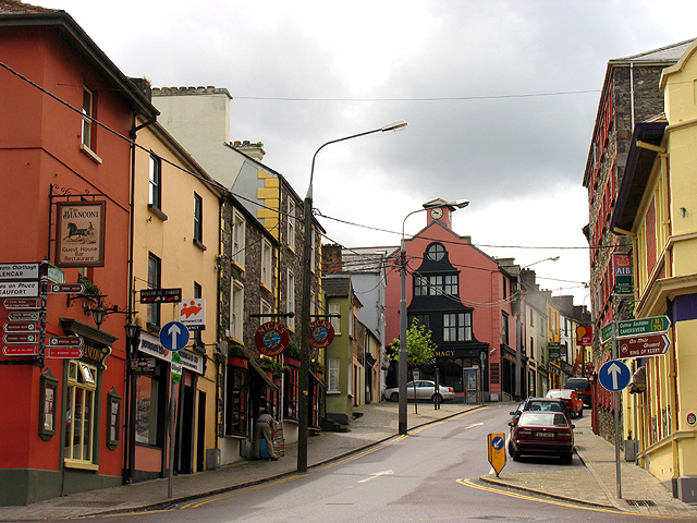
Killorglin (Irish: Cill Orglan, meaning 'Orgla's Church')[2] is a town in County Kerry, Ireland. As of the 2022 census, the town's population was 2,163.[1] Killorglin is on the Ring of Kerry tourist route, and annual events include the August Puck Fair festival, which starts with the crowning and parading of a "king" wild goat.[3] The town is 26 km south of Tralee along the N70 road, and 22 km west of Killarney along the N72 road. Killorglin is in a civil parish of the same name.[2]
Key Information


History
[edit]Origins and development
[edit]The earliest evidence of ancient settlement in the Killorglin area is the presence of prehistoric rock art. These rock carvings are part of a Late Neolithic/Early Bronze Age tradition stretching across Atlantic Europe and occur in concentrations around the Iveragh and Dingle peninsulas, with a cluster close to the nearby town of Glenbeigh.[4] There are also a number of ringforts and early Christian ecclesiastical sites in the townlands of Dromavally and Castleconway.[5] The ruins of Killorglin Castle, later known as Castle Conway, are located close to what is now the centre of the town. It was built in the early 13th century by Maurice FitzGerald, 2nd Lord of Offaly.[5]
The area was held by the FitzGerald dynasty until the confiscation of their lands following the Desmond Rebellions in the late 16th century. In 1587, as part of the Munster Plantation, Killorglin (and its castle) was granted to Captain Jenkin Conway.[6][7]

Much of the town centre was laid out in the 19th century.[6] Killorglin's Roman Catholic church was built (on the site of an earlier church) in 1891.[6] The Church of Ireland church was originally built in 1816 and significantly redeveloped in 1868.[6] The town hall was built in the early 20th century with the help of Andrew Carnegie.[8]
Ballykissane 1916
[edit]On Ballykissane Pier is a monument to commemorate the deaths of several Irish Volunteers, the first casualties of the Easter Rising in 1916. They were in a car that plunged off the pier into the River Laune while on the way to make contact with Roger Casement and a German arms ship masquerading as the Aud.
On Good Friday 21 April 1916, six Irish Volunteers set off from Dublin by train to Killarney. From there, they were to travel by car to Cahirciveen in order to seize control of the wireless station on Valentia Island. Thomas McInerney, who drove a car carrying three of the men, become lost just outside Killorglin and turned onto the road which led to the quay. The front wheels of the car went over the edge of the quay, became unbalanced, and fell into the River Laune. McInerney was the only person to escape the car and swim to shore. The other three occupants remained trapped in the vehicle and drowned.[9]
Economy and tourism
[edit]
Fexco, a major financial services company, was founded in Killorglin in 1981 and is still headquartered in the town. Pharmaceutical firms Temmler and Astellas have small plants in Killorglin. It also has the operations centre for the Prize Bond Company.[10]
A 100m wind turbine was erected at the Astellas Plant on the Tralee Road in 2012 and has become a local landmark [11]
Killorglin is on the Wild Atlantic Way and Ring of Kerry tourist routes.[3] A visitor centre for the Reeks District is also located in the town.[12]
Culture
[edit]Puck Fair
[edit]
Killorglin is known for the annual Puck Fair festival, which traditionally starts with the crowning of a "king" goat.[3] There is a large bronze King Puck statue on the edge of town close to the bridge. This statue was commissioned by the Killorglin Millennium Committee and designed by Valentia Island Sculptor Alan Ryan Hall. The King Puck Statue and Puck Garden was completed in 2001 and officially unveiled by Killorglin Lord Mayor Paudie Cronin and the Killorglin Millennium Committee.
In 2011, The Puck Poet plaques were added to the Puck Garden to recall some of the writers and poets who have written about Killorglin. These include Edso Crowley, Sigerson Clifford, Peter Joy and Johnny Patterson.
Film
[edit]The father of Academy Award-winning actor Ed Begley (1901–1970) was born in Laharn, Killorglin.[citation needed]
The Academy Award for Best Animated Short Film-nominated stop-motion film Head Over Heels (2012) was produced by Cromane filmmaker Fodhla Cronin O'Reilly. Cronin O'Reilly attended secondary school in Killorglin.[citation needed]
As of 2015, Áine Moriarty from Killorglin was head of the Irish Film & Television Academy (IFTA). Killorglin actor Muiris Crowley starred in the film Pilgrim Hill (2013). It was directed by fellow Kerryman Gerard Barrett.[citation needed]
Music and events
[edit]Killorglin and its Puck Fair feature in a number of traditional Irish ballads and songs, including Bridget Donohue written by Johnny Patterson, King Puck by Christy Moore, and Wildflower of the Laune by Peter Joy.
A local tradition, Biddy's Day, occurs in the area during February. It involves groups, in traditional dress, visiting homes carrying a Brídeóg (or Biddy) effigy to ensure good luck.[13] In 2019, this Mid-Kerry practice was one of 30 "Intangible cultural heritage" traditions afforded recognition by the state.[14]
Literature
[edit]Books about Killorglin, or by Killorglin natives, include:[citation needed]
- Things My Mother Never Told Me (2003), by Blake Morrison, tells the story of the author's mother who was from Killorglin and emigrated to England.[citation needed]
- Cast A Laune Shadow (1997), by local historian Patrick (Pa) Houlihan (1918-2010), is a history of the town in story.
- Puck Fair, by Pa's eldest son Michael Houlihan, is about the annual festival in August.
- St James and Fr Tom, by Terence Houlihan and Billy Browne, details the development of St James's Catholic church by Fr Tom Lawlor.
- The Civil War in Kerry, by local historian Tom Doyle, details the part Kerry and Killorglin played in the Irish Civil War.
Sport
[edit]Laune Rangers, the local Gaelic Athletic Association club, won the All-Ireland Senior Club Football Championship in 1996.
Killorglin Rugby Club's Under-16 team won the West Munster Trophy in 2006, and Under-18 squad won the West Munster Trophy in 2008.[citation needed] The rugby club was awarded "Munster Youths Club of the Year" in 2008.[15]
Former members of the local association football club, Killorglin AFC, include Shane McLoughlin (who went on to play with Ipswich Town F.C. and AFC Wimbledon).[16][17][18] The 2009 and 2016 women's solo World Coastal Rowing Champion, Monika Dukarska, is a member of Killorglin Rowing Club.[19][20]
The town is approximately 15 kilometres (9.3 mi) from the base of Carrauntoohil, Ireland's highest mountain, and 50 kilometres (31 mi) from Mount Brandon, Ireland's 2nd highest mountain. Both mountains are centres for hillwalking and mountaineering. The National Centre for Outdoor Education and Training (Cappanalea) is also nearby at Caragh Lake.[21]
People
[edit]- Tom Barry, Irish revolutionary and author[22]
- Máirín Cregan, revolutionary and writer of children's books, was born in Killorglin in 1891[23]
- Mike-Frank Russell, former Kerry GAA footballer and All-Star[24]
- Liam Hassett, 1997 All-Ireland Senior Football Championship winning captain[25]
- Reginald Green, first-class cricketer[26]
- Timothy O'Connor, Fianna Fáil politician who served as a TD for the Kerry South constituency from 1961 to 1981.[citation needed]
References
[edit]- ^ a b "Census Mapping – Killorglin". Census 2022. Central Statistics Office. Retrieved 26 January 2024.
- ^ a b "Cill Orglan / Killorglin". logainm.ie. Irish Placenames Commission. Retrieved 13 December 2020.
- ^ Bradley, R (1997). Signing the Land; Rock Art and the Prehistory of Atlantic Europe. London: Routledge.
- ^ a b A. O'Sullivan; J. Sheehan, eds. (1996). The Iveragh peninsula: an archaeological survey of South Kerry. Cork University Press.
- ^ a b c d "Local Area Plans - Section 2 - Killorglin Local Area Plan" (PDF). kerrycoco.ie. Kerry County Council. Archived from the original (PDF) on 4 March 2016.
- ^ "Estate: Conway (Kerry)". Landed Estates Database. NUI Galway. Retrieved 28 May 2021.[dead link]
- ^ Statement by Thomas O'Donnell (MP), The Irish People, 13 February. 1909, included in a report on Tower Model Village (County Cork)
- ^ "Killorglin during the 1916 Rising". Archived from the original on 25 September 2015. Retrieved 11 September 2015.
- ^ "Annual Report for 2022" (PDF). statesavings.ie. Retrieved 3 June 2024.
- ^ "100m wind turbine plan for Killorglin town - Independent.ie". kerryman.ie. Retrieved 23 April 2018.
- ^ "Reeks District Visitor Information Centre". gokerry.ie. Go Kerry. Retrieved 18 April 2021.
- ^ "Biddy's Day". Archived from the original on 22 January 2017.
- ^ "Mid-Kerry Biddy tradition gets official state recognition". The Kerryman. Independent News & Media. 27 July 2019. Retrieved 3 August 2019.
- ^ "Club History". killorglinrugby.com. Archived from the original on 16 September 2013.
- ^ "New Zealander and Irishman to Join Academy Ranks". twtd.co.uk. 8 May 2013. Retrieved 18 April 2021.
- ^ "PRO DEALS FOR TOWN SIX - News - Ipswich Town". itfc.co.uk. Retrieved 23 April 2018.
- ^ "'I went against the grain by not playing GAA ... but it wasn't what I wanted to do'". independent.ie. Independent News & Media. 16 February 2019. Retrieved 28 May 2021.
- ^ "Blades of glory: How a girl from Poznan, who settled in Killorglin, is on her way to the Olympics". independent.ie. Independent News & Media. 10 May 2020. Retrieved 28 May 2021.
- ^ "Monika Dukarska". rowingireland.ie. Rowing Ireland. Retrieved 28 May 2021.
Monika is a two time World Coastal Champion in the women's solo, winning in 2009 and 2016
- ^ "Cappanalea OETC, Caragh Lake, Killorglin, Co. Kerry". cappanalea.ie. Archived from the original on 10 May 2021. Retrieved 28 May 2021.
- ^ McGreevy, Ronan. "Home advantage – Ronan McGreevy on Tom Barry and the Rosscarbery attack". Irish Times, 22 March 2021. Retrieved 28 May 2021
- ^ "The Kerry Magazine" (PDF) (23). The Kerry Archaeological & Historical Society. 2013: 50.
{{cite journal}}: Cite journal requires|journal=(help) - ^ "20 years on - Mike Frank Russell looks back on the most memorable day in his career". the42.ie. 20 March 2016. Retrieved 20 April 2020.
- ^ "From wild card to trump card: How Liam Hassett is shaking up the Kerry dressing room". irishexaminer.com. Irish Examiner. 27 August 2016. Retrieved 20 April 2020.
- ^ "ESPNcricinfo - Reginald Kilocksley Green". espncricinfo.com.
External links
[edit]
| International | |
|---|---|
| National | |
| Geographic | |
| Other | |
Killorglin
View on GrokipediaGeography and Environment
Location and Topography
Killorglin is situated in mid-Kerry, County Kerry, Republic of Ireland, at the confluence of the River Laune with its tributaries. The town lies approximately 26 km (16 miles) south of Tralee along the N70 road and 22 km (14 miles) west of Killarney via the N72 road.[7] It occupies a strategic position on the N70 national primary route, integral to the Ring of Kerry scenic drive that encircles the Iveragh Peninsula.[8] The topography features a river valley landscape, with Killorglin positioned on an elevated hill overlooking the broad River Laune, which flows northward into Dingle Bay.[9] The surrounding terrain transitions from the flat, fertile alluvial plains along the river—supporting pastoral agriculture—to the rugged slopes of the nearby MacGillycuddy's Reeks mountain range, Ireland's highest, rising sharply to the east and channeling precipitation into the Laune catchment.[10] This proximity to the Reeks, spanning 19 km of sandstone and siltstone peaks, shapes the local drainage and exposes the area to Atlantic weather influences.[11] The River Laune's course through Killorglin necessitates key infrastructure, including multiple bridges such as the historic Upper Bridge and the modern Laune Bridge, facilitating connectivity while managing seasonal flooding from upland runoff.[12] These features underscore the interplay between the valley's gentle gradients and the constraining mountainous backdrop, influencing settlement patterns in the low-lying areas.[13]Climate and Natural Features
Killorglin possesses a temperate oceanic climate (Köppen Cfb), featuring mild winters and cool summers without extreme temperature variations. Average high temperatures during winter months (December to February) range from 9°C to 9.5°C, with lows near 5°C, while summer highs (June to August) reach 17°C to 18°C and lows 12°C to 13°C.[14] The annual mean temperature approximates 11°C.[15] Precipitation is abundant, averaging 1,376 mm annually, with higher totals in autumn and winter due to frequent Atlantic weather systems. The town's proximity to the Atlantic Ocean moderates its climate, maintaining relatively consistent conditions influenced by maritime air masses. Adjacent uplands, including the MacGillycuddy's Reeks range to the south, contribute to localized rainfall enhancement through elevation-driven condensation, while the River Laune valley provides some shelter from prevailing westerly winds. These factors result in persistently high humidity and overcast skies, with wet days comprising more than 40% of winter periods.[14] Natural features center on the River Laune, which bisects Killorglin after descending from upstream lakes and mountains, draining into the estuarine wetlands of Castlemaine Harbour. This riverine system periodically generates flood risks, as evidenced by overtopping events in January 2014 and February 2021, which submerged local roads like the N72 and affected properties due to heavy rainfall and tidal interactions.[16] Surrounding wetlands sustain modest biodiversity, hosting wetland flora and fauna documented in area-specific surveys, though constrained by hydrological fluctuations and human land use.[17]History
Early Origins and Settlement
The presence of prehistoric rock art in the landscapes surrounding Killorglin attests to early human activity during the Late Neolithic or Bronze Age periods, circa 2500–1500 BC, when communities likely engaged in ritual practices or territorial demarcation amid the resource-abundant Kerry uplands. Artifacts such as the Laharn Cauldron, dated to approximately 2500 BC and associated with the locality, further indicate Bronze Age metalworking and settlement patterns influenced by the proximity to rivers and coasts for hunting, gathering, and early metallurgy.[18][19] Killorglin's name originates from the Irish Cill Orglan, translating to "church of Orglan," signifying an early Christian foundation probably dating to the 5th–7th centuries AD, when ecclesiastical sites proliferated as centers of learning, agriculture, and community organization in Gaelic Ireland. This church, with remnants including four walls visible at historic sites, positioned Killorglin as a key river-crossing on the Laune, leveraging the estuary's tidal access for transport and defense while fostering dispersed habitation rather than urban development.[20][21] The fertile Laune valley, with its alluvial soils and salmon-rich waters, causally drew early medieval Gaelic groups for mixed subsistence economies centered on fishing, cereal cultivation, and pastoralism, supplemented by the estuary's role in seasonal migration and trade routes. Ringforts and enclosures in the broader Kerry region, constructed from the 5th to 9th centuries, reflect defensive farming settlements exploiting similar topographic advantages, though archaeological surveys confirm no concentrated pre-Norman town existed at Killorglin itself, only proto-communities tied to ecclesiastical and agrarian imperatives.[22]Medieval Development and Norman Influence
Following the Anglo-Norman invasion of Ireland in the 1170s, Killorglin emerged as a frontier settlement in County Kerry, positioned at the strategic crossing of the River Laune amid contested territories between Gaelic clans and Norman incursions. By the early 13th century, the area served as the caput of cantreds held by Geoffrey de Marisco, a Norman lord under royal grant, who constructed or fortified Killorglin Castle to assert control over native kingdoms like Corca Dhuibhne.[23][24] This castle functioned as a defensive outpost amid ongoing raids, with records indicating its razing during conflicts between Norman lords and Irish forces allied against them in the late 13th century.[25] The manor's feudal structures reflected hybrid lordship, as evidenced by 1302 extents showing rents extracted from Gaelic Irish under the Desmond earldom's oversight, highlighting Killorglin's role in tribute collection rather than full colonization.[26] Around 1287, possession shifted to the FitzGerald Geraldines of Shanid, precursors to the Earls of Desmond, who integrated it into their Munster-wide domains, fostering limited economic activity through tolls and agrarian levies amid persistent border skirmishes.[27] Attempts to reclaim the manor, such as Thomas fitz Maurice's 1289 challenge against Emelina de Longespee, underscore the contested nature of holdings, shaped by royal interventions and local alliances rather than stable Norman dominance.[28] Defensive imperatives drove settlement patterns, with annals and extents documenting raids that necessitated fortified manors like Killorglin to secure riverine trade routes against Gaelic resurgence, though effective control remained episodic due to Kerry's rugged terrain and sparse Norman implantation.[29] By the 14th century, under Desmond FitzGerald stewardship, nascent markets supported feudal exchanges, evidenced by manorial revenues, positioning Killorglin as a liminal economic node between Gaelic pastoralism and Anglo-Norman agrarian impositions.[26]19th-Century Growth and Industrial Beginnings
Prior to the Great Famine (1845–1852), Killorglin experienced population growth driven by reliance on potato cultivation for subsistence and small-scale farming, characteristic of rural Kerry's economy.[30] The famine caused severe depopulation through starvation, disease, and emigration across the region, with Kerry's overall numbers halving between 1841 and 1901; Killorglin shared in this decline as markets faltered and relief efforts strained local resources.[31][32] Post-famine recovery in Killorglin was supported by enhanced transportation infrastructure linking the town to Tralee and Killarney. Charles Bianconi's long-car coach services, operational from around 1828, provided regular connections for passengers and goods, fostering trade despite the era's challenges.[33] The construction of a durable stone bridge over the River Laune in 1885 replaced a vulnerable wooden predecessor frequently damaged by floods, improving road reliability and commerce flow.[34] The arrival of the railway branch line at Killorglin in 1885 marked a pivotal advancement, enabling efficient export of agricultural produce and attracting merchants to local markets.[35] Electoral divisions around Killorglin recorded relatively high population growth rates amid broader Kerry trends, reflecting self-reliant rural revitalization through these developments.[6] Fairs and markets, evolving from traditional gatherings, gained structure and scale, serving as vital hubs for livestock exchange and prefiguring formalized events that sustained economic resilience.[36]20th-Century Events and Ballykissane 1916
On Good Friday, 21 April 1916, three Irish Volunteers—Cornelius “Con” Keating from Reenard near Cahersiveen, Donal Sheehan from Newcastle West, and Charles Monahan from Belfast—drowned when the car they were traveling in drove off Ballykissane Pier, approximately 1.5 miles from Killorglin, into deep, fast-flowing water of the River Laune around 9:45 p.m.[37] The group, including chauffeur Thomas McInerney from Limerick, was transporting wireless equipment intended for use in the planned Easter Rising amid poor visibility and navigational error at the unlit pier.[37] McInerney swam to shore with aid from local Timothy Sullivan, who provided a light, but Keating sank while attempting to pray after initial rescue efforts; the bodies of the three victims were recovered later.[37] Inquests attributed the deaths to accidental drowning due to the pier's inadequate lighting and safety features, with no initial suspicion of revolutionary activity, as the rebellion's context emerged only post-event; these fatalities marked the first recorded losses tied to the 1916 Rising.[37] During the Irish Civil War, Killorglin became a flashpoint in late September 1922, when an anti-Treaty IRA force of around 500 attacked the town held by Free State National Army troops, resulting in sustained fighting from 27 to 29 September.[38][39] The engagement involved Republican offensives aimed at disrupting supply lines to Free State garrisons, including those in Killorglin and nearby Castlemaine, with casualties among Kerry-born National Army soldiers reported in the clashes.[39][40] This battle exemplified Kerry's intense Civil War hostilities, where local Republicans initially controlled the area before Free State reinforcements repelled the assault.[41] In the interwar period, Killorglin received electricity supply through the local Killorglin Electric Light and Power Co., Ltd., which operated prior to nationalization under the Electricity Supply Board in 1927.[42] Post-World War II modernization efforts included the closure of the local railway branch line in 1960, shifting reliance toward road infrastructure amid broader rural electrification and development initiatives in Ireland during the 1950s and 1960s.[43]Demographics and Society
Population Statistics and Trends
According to the 2022 Census of Population by Ireland's Central Statistics Office (CSO), Killorglin recorded 2,163 usual residents.[44][2] This figure reflects a minor annual decline of 0.28% from the 2016 census total of 2,199.[1] Historical census data illustrate a pattern of post-famine recovery followed by gradual growth into the late 20th century, with stabilization in recent decades amid broader rural depopulation trends in Ireland.[45] The table below summarizes key census figures for Killorglin:| Census Year | Population |
|---|---|
| 1926 | 1,229 |
| 1936 | 1,278 |
| 1946 | 1,359 |
| 1961 | 1,627 |
| 2016 | 2,199 |
| 2022 | 2,163 |