
Community hub
Recent from talks
Contribute something
Nothing was collected or created yet.
Kismayo
View on WikipediaKismayo (Somali: Kismaayo, 𐒏𐒘𐒈𐒑𐒛𐒕𐒙) is a port city in the southern Lower Juba (Jubbada Hoose) province of Somalia. It is the de facto capital of the autonomous Jubaland region.
Key Information


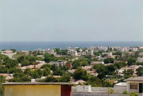
The city is situated 528 kilometres (328 miles) southwest of the capital Mogadishu, near the mouth of the Jubba River, where it empties into the Indian Ocean. According to the United Nations Development Programme, the city of Kismayo had a population of around 89,333 in 2005.[2]
During the Middle Ages, Kismayo and its surrounding area was part of the Ajuran Empire that governed much of southern Somalia and eastern Ethiopia, with its domain extending from Hafun in the north, to Qelafo in the west, to Kismayo in the south.[3][4]
In the early modern period, Kismayo was ruled by the Geledi Sultanate and by the later 1800s, the Boqow dynasty. The kingdom was eventually incorporated into Italian Somaliland in 1925/6 after the death of the last sultan, Osman Ahmed.[5] After independence in 1960, the city was made the center of the official Kismayo District.
Kismayo was the site of numerous battles during the civil war, from the early 1990s.[6] In late 2006, Islamist militants affiliated with Al-Shabaab gained control of most of the city. To reclaim possession of the territory, a new autonomous regional administration dubbed Azania was announced in 2010 and formalized in 2011. In September 2012, the Somali National Army and AMISOM troops re-captured the city from the Al-Shabaab insurgents.[7] The Juba Interim Administration was established and recognized in 2013.[8]
Demographics
[edit]Kismayo, a key port city in southern Somalia, is known for its diverse population. The Marehan clan (a Darod sub-clan) and the Harti (sub-clan of Darod) and Sheekhal (Hawiye), are widely recognized as the majority groups in the city, with long-standing dominance in local demographics, federal alignment, and influence over military structures.[9]
The Ogaden sub-clan (Mohamed Zubeyr) is also present in the city, though their political role has been controversial. The administration of Ahmed Madobe, an Ogaden Warlord, claims control over Jubaland from Kismayo. However, his authority has been rejected by the Federal Government of Somalia, including President Hassan Sheikh Mohamud, who declared that the Jubaland leadership lacked constitutional legitimacy and was not federally recognized.[10]
Other communities residing in Kismayo include Bimaal (Dir) and Gaalje'el (Hawiye), two historically significant Somali clans with deep cultural roots in the region; Tunni (Digil–Mirifle / Rahanweyn), an agro-pastoral clan native to the Lower Shabelle and Jubba regions; Somali Bantu (Jareer), a historically marginalized community with a distinct heritage; Bajuni (coastal minority), a coastal group with longstanding maritime traditions; and Sheekhal (Hawiye), known for their religious leadership.
According to estimates by humanitarian agencies, the city had around 234,000 residents as of 2014, though figures have fluctuated due to conflict, displacement, and return movements.[11]
History
[edit]Antiquity
[edit]During antiquity, Kismayo was part of the Somali city-states that in engaged in a lucrative trade network connecting Somali merchants with Phoenicia, Ptolemic Egypt, Greece, Parthian Persia, Saba, Nabataea and the Roman Empire. Somali sailors used the ancient Somali maritime vessel known as the beden to transport their cargo.[12]
Middle Ages and the early modern period
[edit]_flag_according_to_1576_Portuguese_map.svg)
The Kismayo area was originally a small fishing settlement.[3]
During the Middle Ages, the region came under the rule of the influential Ajuran Sultanate, which utilized the Jubba River for its plantations.
After the collapse of this polity, the House of Gobroon was established and the Sultanate of the Geledi held sway over the area. The dynasty reached its apex under the successive reigns of Sultan Yusuf Mahamud Ibrahim, who successfully consolidated Gobroon power during the Bardera wars, and Sultan Ahmed Yusuf, who forced regional powers such as the Omani Empire to submit tribute.
Colonial Era
[edit]Until 1886, the Sultanate of Zanzibar controlled a substantial portion of the Swahili Coast, known as Zanj. Following the Berlin Conference of 1885, the British and Germans secretly agreed their spheres of influence, with the British to take what would become the East Africa Protectorate. Both powers leased coastal territory from Zanzibar and established trading stations and outposts. William Mackinnon, who already had an agreement with the Sultan, formed the Imperial British East Africa Company in 1888 and the company was given the original grant to administer the territory, leased from the Sultan. It administered about 240 km (150 mi) of coastline stretching from the River Jubba via Mombasa to German East Africa. The company failed and on 1 July 1895 the British government proclaimed a protectorate, the East Africa Protectorate, the administration being transferred to the Foreign Office.[13]

To reward the Italians for joining the Allies in World War I,[14] and following the Corfu incident of 1923, Britain decided to cede Kismayo and the northern half of Jubaland unconditionally to the Italian colonial empire.[15] The northern half of the partitioned Jubaland territory, had a brief existence from 1924 as the Italian colony of Trans-Juba (Oltre Giuba). The Italians referred to the city as Chisimaio. The colony had a total area of 87,000 km2 (33,000 sq mi), with a population of 120,000 inhabitants. Jubaland was then incorporated into neighbouring Italian Somaliland on 30 June 1926.
Britain retained control of the southern half of the partitioned Jubaland territory, which was later called the Northern Frontier District (NFD).[16] In 1941 Operation Canvas was launched from the NFD with the Battle of the Juba. Kismayo was quickly captured by 14 February.[17][18]
Somali Civil War
[edit]Following the breakdown of central authority that accompanied the civil war in 1991, various local militias fought for control of the city, including supporters of Mohammed Said Hersi ("General Morgan"), and Col. Barre Adan Shire Hiiraale Somali National Front (SNF), later on known as the Juba Valley Alliance (JVA). As well of Col. Omar Jess' Somali Patriotic Movement (SPM). Aid worker Sean Devereux was assassinated in the city in January 1993. In March 1993, a United States Marine amphibious group arrived in the city in an attempt to keep the peace as part of the United Nations intervention in Somalia. By December 1993, General Morgan's troops controlled Kismayo, despite the presence of peacekeepers. The last UN troops left the city in December 1994.[19]

General Morgan briefly declared Jubaland independent on September 3, 1998.[20] Political opponents of his subsequently united as the Allied Somali Forces (ASF), seizing control of Kismayo by June of the following year.[21] Led by Colonel Barre Adan Shire Hiiraale, the ASF administration renamed itself the Juba Valley Alliance in 2001.[22] On June 18 of that year, an 11-member interclan council decided to ally the JVA with the newly forming Transitional Federal Government.[23]
On January 8, 2007, as the Battle of Ras Kamboni raged just south of Kismayo, the TFG relocated from its interim location in Baidoa to the nation's capital, Mogadishu. This marked the first time since the fall of the Siad Barre regime in 1991 that the federal government controlled most of the country.[24]
Following this defeat, the Islamic Courts Union splintered into several different factions. Some of the more radical elements, including Al-Shabaab, regrouped to continue their insurgency against the TFG and oppose the Ethiopian military's presence in Somalia. Throughout 2007 and 2008, Al‑Shabaab scored military victories, seizing control of key towns and ports in both central and southern Somalia. By January 2009, Al‑Shabaab and other militias had managed to force the Ethiopian troops to retreat, leaving behind an under-equipped African Union peacekeeping force to assist the Transitional Federal Government's troops.[25]
In September 2012, Somali Army, Ras Kamboni militiamen and Kenyan Defense Forces (KDF), all under command of the African Union Mission in Somalia AMISOM, re-captured the city from the Al-Shabaab insurgents during the Battle of Kismayo (2012).[7][26] This was a culmination to the Kenyan Operation Linda Nchi attack into Somalia which had begun late the year before.
On 12 July 2019, a car bomb and a gun attack at the Asasey hotel killed at least 26, including two prominent journalists and nine foreigners. Islamist group al-Shabaab claimed responsibility.[27]
Geography
[edit]Location
[edit]Kismayo is located in the fertile Juba Valley in southeastern Somalia, on the Somali Sea coast. Nearby settlements include to the northeast Xamareyso (5.0 nm), to the north Dalxiiska (1.3 nm), to the northwest Qeyla Dheere (6.4 nm), to the west Saamogia (0.9 nm), to the southwest Iach Bulle (10.0 nm), and to the south Qandal (6.5 nm).[28] The largest cities in the country most proximate to Kismayo are Jamaame (52 km), Jilib (97 km), and Merca (337 km).[29]
Places adjacent to Kismayo | ||||||||||||||||
|---|---|---|---|---|---|---|---|---|---|---|---|---|---|---|---|---|
| ||||||||||||||||
Climate
[edit]Kismayo has a tropical semi-arid climate (Köppen climate classification BSh) Weather is hot year-round, with seasonal monsoon winds and irregular rainfall with recurring droughts. The gu rains, also known as the Southwest Monsoons, begin in April and last until July producing significant fresh water and allowing lush vegetation to grow. The gu season is followed by the xagaa (hagaa) dry season.
| Climate data for Kismayo | |||||||||||||
|---|---|---|---|---|---|---|---|---|---|---|---|---|---|
| Month | Jan | Feb | Mar | Apr | May | Jun | Jul | Aug | Sep | Oct | Nov | Dec | Year |
| Record high °C (°F) | 31.8 (89.2) |
33.1 (91.6) |
34.0 (93.2) |
37.8 (100.0) |
34.0 (93.2) |
34.0 (93.2) |
32.3 (90.1) |
32.4 (90.3) |
30.3 (86.5) |
31.5 (88.7) |
32.2 (90.0) |
33.0 (91.4) |
37.8 (100.0) |
| Mean daily maximum °C (°F) | 29.6 (85.3) |
29.9 (85.8) |
31.0 (87.8) |
31.8 (89.2) |
30.4 (86.7) |
28.6 (83.5) |
28.0 (82.4) |
28.3 (82.9) |
28.6 (83.5) |
29.5 (85.1) |
30.5 (86.9) |
30.5 (86.9) |
29.7 (85.5) |
| Daily mean °C (°F) | 27.1 (80.8) |
27.3 (81.1) |
28.2 (82.8) |
28.6 (83.5) |
27.3 (81.1) |
26.1 (79.0) |
25.6 (78.1) |
25.7 (78.3) |
26.0 (78.8) |
26.8 (80.2) |
27.5 (81.5) |
27.5 (81.5) |
27.0 (80.6) |
| Mean daily minimum °C (°F) | 24.2 (75.6) |
24.5 (76.1) |
25.4 (77.7) |
25.8 (78.4) |
24.8 (76.6) |
23.5 (74.3) |
23.1 (73.6) |
23.3 (73.9) |
23.3 (73.9) |
24.0 (75.2) |
24.5 (76.1) |
24.4 (75.9) |
24.2 (75.6) |
| Record low °C (°F) | 21.0 (69.8) |
22.0 (71.6) |
23.0 (73.4) |
21.3 (70.3) |
20.0 (68.0) |
21.0 (69.8) |
19.0 (66.2) |
21.0 (69.8) |
22.0 (71.6) |
22.4 (72.3) |
22.5 (72.5) |
22.0 (71.6) |
19.0 (66.2) |
| Average rainfall mm (inches) | 1 (0.0) |
1 (0.0) |
3 (0.1) |
69 (2.7) |
121 (4.8) |
99 (3.9) |
52 (2.0) |
21 (0.8) |
21 (0.8) |
15 (0.6) |
17 (0.7) |
3 (0.1) |
424 (16.7) |
| Average rainy days (≥ 0.1 mm) | 0 | 0 | 0 | 4 | 7 | 11 | 9 | 5 | 3 | 2 | 2 | 1 | 43 |
| Average relative humidity (%) | 77 | 76 | 76 | 77 | 80 | 80 | 80 | 79 | 78 | 78 | 77 | 77 | 78 |
| Mean monthly sunshine hours | 235.6 | 226.0 | 248.0 | 210.0 | 257.3 | 207.0 | 192.2 | 251.1 | 225.0 | 248.0 | 225.0 | 217.0 | 2,742.2 |
| Mean daily sunshine hours | 7.6 | 8.0 | 8.0 | 7.0 | 8.3 | 6.9 | 6.2 | 8.1 | 7.5 | 8.0 | 7.5 | 7.0 | 7.5 |
| Percentage possible sunshine | 64 | 73 | 69 | 62 | 59 | 57 | 56 | 62 | 64 | 66 | 66 | 66 | 64 |
| Source 1: Deutscher Wetterdienst[30] | |||||||||||||
| Source 2: Food and Agriculture Organization: Somalia Water and Land Management (percent sunshine)[31] | |||||||||||||
Government
[edit]A new municipal district administration was established on 6 September 2008. Its members reportedly represented the ICU and Al‑Shabaab (three members each) in addition to a local clan (one member) which had played a part in the military assault.[32] Representatives of the Islamic Courts Union questioned the legitimacy of the authority.[33] On 1 October 2009, Al Shabaab took full control of the city, after Sheikh Ahmed Madobe, a senior commander of Ras Kamboni Brigade (then a part of Hizbul Islam), challenged Al‑Shabaab's control.[34]
With the subsequent ouster of the Al-Shabaab rebels in September 2012, the Somali government began preparing mediations between the city's various stakeholders in order to establish an inclusive local administration.[35] On 28 August 2013, the autonomous Jubaland administration signed a national reconciliation agreement in Addis Ababa with the federal government. Endorsed by the federal State Minister for the Presidency Farah Abdulkadir on behalf of President Hassan Sheikh Mohamud, the pact was brokered by the Foreign Ministry of Ethiopia and came after protracted bilateral talks.
Under the terms of the agreement, Jubaland is administered for a two-year period by a Juba Interim Administration and led by the region's incumbent president, Ahmed Mohamed Islam. The regional president serves as the chairperson of a new Executive Council, to which he appoints three deputies. Additionally, the agreement includes the integration of Jubaland's military forces under the central command of the Somali National Army (SNA), and stipulates that the Juba Interim Administration will command the regional police.[8][36]
Districts
[edit]Kismayo is divided into 4 districts, or degmo (see map):
- Calanley
- Farjano
- Shaqaalaha
- Fanoole
Education
[edit]Institutions of higher learning in the city include Kismayo University (KU). Established in August 2005, it is situated about 1 km north, along the Kismayo–Mogadishu main road.[37]
Economy
[edit]In October 2008, the daily labor rate was estimated at 157,500 Somali shillings (approximately $4.50), up from 52,000 shillings (approximately $2.21) in January 2008, while a kilogram of red rice rose from 14,170 (approximately $0.61) to 46,000 (approximately $1.31).[38] A liter of diesel cost 43,000 shillings (approximately $1.23) and a camel costs over 15 million shillings (approximately $435). Total cereal production as of 2008 was estimated to be 780MT.[39]
Transportation
[edit]Airport
[edit]
Kismayo's air transportation needs are served by Kismayo Airport, which is situated about 10 km from the city. It was formerly a Somali Air Force training base. Following the outbreak of the civil war, the airport was closed down for a period of time and its infrastructure was significantly damaged. However, the facility was reopened in October 2008 by the Islamic Courts Union after undergoing some renovations.[40] That same year, the airport was also renamed after Imam Ahmed Gurey, a 16th‑century Somali military leader.[41]
The Kismayo Airport was officially brought under the Juba Interim Administration in August 2013. Per agreement, management of the facility was scheduled to be transferred to the Federal Government after a period of six months. Revenues and resources generated from the airport will also be earmarked for Jubaland's service delivery and security sectors as well as local institutional development.[8]

Roads
[edit]Three main thoroughfares connect Kismayo to other major areas in the country. The 600 km Highway 3 runs the length of the Juba Valley. Starting in Beled Hawo, it goes through Garbaharey, Bardera and Buale before finally reaching Kismayo.
A paved 528 km freeway links the capital Mogadishu with Kismayo, passing through Jilib before turning towards the capital. A third highway extends northwest from Kismayo to Afmadow, then turns toward Dhobley in the eastern part of the Gedo region.
In January 2015, the Interim Juba Administration launched a transport beautification and cleaning campaign in Kismayo. Part of a broader urbanization drive, the initiative includes the clearing of clogged streets and lanes, razing of illegal buildings therein, and further development of the municipal road network.[42]
Seaport
[edit]Kismayo's large docks are situated on a peninsula on the Somali Sea coast. Formerly one of the Bajuni Islands, the peninsula was connected by a narrow causeway when the modern Port of Kismayo was built in 1964 with U.S. assistance. The port served as a base for the Somali Navy as well as the Soviet Navy after the 1969 military coup.[43] In 1984, Somalia and the United States jointly refurbished the port after significant wear to the 2,070-foot-long (630 m) four-berth, marginal wharf made major renovations necessary.[44]
The Port of Kismayo was officially brought under the Juba Interim Administration in August 2013. According to the agreement, management of the facility was scheduled to be transferred to the Somali Federal Government after a period of six months. Like Kismayo Airport, revenues and resources generated by the seaport are to be earmarked for Jubaland's service delivery and security sectors as well as local institutional development.[8]
Notable residents
[edit]- Mohammed Sagaf, footballer born in Kismayo, currently representing Tanzania national football team
- Mohamed Ibrahim Liqliiqato, military and political leader; ambassador to the Soviet Union and West Germany; Speaker of Parliament (1983–1990)
- Abdullahi Ahmed Irro, general in the Somali National Army
- Hussein Samatar, politician, banker and community organizer
See also
[edit]References
[edit]- ^ PopulationStat Population of Kismayo, city and urban area
- ^ "Regions, districts, and their populations: Somalia 2005 (draft)" (PDF). United Nations Office for the Coordination of Humanitarian Affairs. United Nations Development Programme. Archived from the original (PDF) on 2017-07-28. Retrieved 2020-12-31.
- ^ a b Lee V. Cassanelli, The shaping of Somali society: reconstructing the history of a pastoral people, 1600–1900, (University of Pennsylvania Press: 1982), p.102.
- ^ Fage, J. D.; Oliver, Roland (1975). The Cambridge History of Africa. Cambridge University Press. p. 137. ISBN 978-0-521-20981-6.
- ^ Cassanelli, Lee Vincent (1973). The Benaadir Past: Essays in Southern Somali History. University Microfilms International. p. 149.
- ^ "From the Bottom Up:—Conflict Dynamics International, Inc". Archived from the original on 2019-07-14.
- ^ a b "Somali, AMISOM forces on the outskirts of Kismayo" (PDF). AMISOM. Retrieved 30 July 2014.
- ^ a b c d "Somalia: Jubaland gains recognition after intense bilateral talks in Ethiopia". Garowe Online. 28 August 2013. Archived from the original on 12 October 2013. Retrieved 11 September 2013.
- ^ European Union Agency for Asylum (EUAA), Country Guidance: Somalia – Lower Juba, 2023. https://euaa.europa.eu/country-guidance-somalia-2023/lower-juba
- ^ International Crisis Group, Jubaland in Jeopardy, 2022. https://www.crisisgroup.org/africa/horn-africa/somalia/b158-jubaland-jeopardy
- ^ UNHCR, Area-Based Return Monitoring: Kismayo, 2020. https://help.unhcr.org/kenya/wp-content/uploads/sites/29/2021/06/UNHCR_AreaReturnBrochure_Kismayo_2020.pdf
- ^ Journal of African History pg.50 by John Donnelly Fage and Roland Anthony Oliver
- ^ Cana, Frank Richardson (1911). . In Chisholm, Hugh (ed.). Encyclopædia Britannica. Vol. 4 (11th ed.). Cambridge University Press. pp. 604–606.
- ^ Oliver, Roland Anthony (1976). History of East Africa, Volume 2. Clarendon Press. p. 7. and Hornsby, Kenya: A History Since Independence, 2012, 21.
- ^ Steiner, Zara (2005). The lights that failed : European international history, 1919-1933. Oxford: Oxford University Press. ISBN 978-0-19-151881-2. OCLC 86068902.
- ^ Osman, Mohamed Amin AH (1993). Somalia, proposals for the future. SPM. pp. 1–10.
- ^ Jackson, Ashley (2006). The British Empire and the Second World War. Continuum International Publishing Group. p. 214. ISBN 978-1-85285-417-1.
- ^ Vincent, Dennis (2024). The Forgotten General: The Life of General Sir Alan Cunningham GCMG, KCB, DSO, MC. Amberley Publishing. ISBN 978-1-3981-1399-2.
- ^ N.Y. Times, World News Briefs; Last U.N. Peacekeepers Prepare to Leave Somalia, December 12, 1994
- ^ Footnotes to History: G to J Archived 2016-03-03 at the Wayback Machine Footnotes to History
- ^ Somalia Assessment, September 1999 Country Information and Policy Unit, Immigration & Nationality Directorate, Home Office, UK
- ^ "Somalia". World Statesmen. Retrieved March 9, 2006. – also shows Italian colonial flag & links to map
- ^ Report of the Secretary-General on the situation in Somalia, 11 Oct 2001, Document S/2001/963 United Nations Security Council
- ^ Somalia President, Parliament Speaker dispute over TFG term Archived 2011-05-14 at the Wayback Machine
- ^ United Nations High Commissioner for Refugees (2009-05-01). "USCIRF Annual Report 2009 – The Commission's Watch List: Somalia". Unhcr.org. Archived from the original on 2011-05-10. Retrieved 2010-06-27.
- ^ "Jubaland in Jeopardy: The Uneasy Path to State-Building in Somalia". International Crises Group. 21 May 2013.
- ^ "Kismayo attack: At least 26 dead as gunmen storm Somali hotel", BBC News, 13 July 2019, retrieved 13 July 2019
- ^ "Kismaayo, Somalia". Falling Rain. Retrieved 7 June 2013.
- ^ "Kismayo (Chisimayu, Kismayu)". Weather-Forecast. Retrieved 7 June 2013.
- ^ "Klimatafel von Chisimaio (Kismayu) / Somalia" (PDF). Baseline climate means (1961–1990) from stations all over the world (in German). Deutscher Wetterdienst. Retrieved 24 October 2016.
- ^ "Long term mean monthly sunshine fraction in Somalia". Food and Agriculture Organization. Archived from the original on 5 October 2016. Retrieved 4 November 2016.
- ^ Garowe Online 2008, 'Somalia's Islamists appoint Kismayo administration' Archived 2008-09-16 at the Wayback Machine, Garowe Online, 6 September. Retrieved on 7 September 2008.
- ^ All Africa, Islamic Courts Reject Administration Formed By Al-Shaabab in Kismayu city, Sep. 8, 2008
- ^ Garowe Online, 'Al Shabaab seize control of Kismayo after battle' Archived 2009-10-08 at the Wayback Machine, Garowe Online, 1 October. Retrieved on 4 October 2009.
- ^ "African troops enter Somali port of Kismayo". AFP. 2 October 2012. Retrieved 2 October 2012.
- ^ Wendoson, Abera. "Somalia gives recognition to Jubaland interim administration". Ethiopian Herald. Archived from the original on 11 September 2013. Retrieved 11 September 2013.
- ^ "Kismayo University". Archived from the original on 2008-08-20. Retrieved 2011-09-11.
- ^ Food Security Analysis Unit – Somalia, Food and Agriculture Organization of the United Nations, 2008 Commodities Prices
- ^ Food Security Analysis Unit – Somalia, Food and Agriculture Organization of the United Nations, Southern Regions Analysis, September 12, 2008
- ^ Abdulkadir Khalif, Somalia: Flights Carrying Khat Banned From Kismayu Airport, 6 October 2008
- ^ AFP, Somalia Islamists rename Kismayo airport Archived 2008-10-11 at the Wayback Machine, 6 October 2008
- ^ "The police commission of Kismayo plans to bulldoze the illegal buildings along the main roads". Goobjoog. 16 January 2015. Retrieved 18 January 2015.
- ^ UPI, U.S. Will Spend $38.6 Million To Refurbish Port in Somalia, September 20, 1984
- ^ R. Lee Hadden, Topographic Engineering Center, U.S. Army Corps of Engineers, The Geology of Somalia: a Selected Bibliography of Somalian Geology, Geography and Earth Science, February 2007
External links
[edit]
| International | |
|---|---|
| National | |
Kismayo
View on GrokipediaKismayo (also spelled Kismaayo) is a major seaport city in southern Somalia, situated on the Indian Ocean coast near the mouth of the Jubba River, and serves as the de facto capital of the Jubaland region.[1][2] Founded in 1872 by the Sultan of Zanzibar, the city was subsequently controlled by British forces from 1887 and later incorporated into Italian Somaliland in 1927, developing as a key trading hub linked to inland agricultural areas.[1] Its port facilities, renovated in the late 20th century to handle exports from the fertile Juba River basin such as bananas and livestock, position Kismayo among Somalia's primary seaports alongside Mogadishu and Berbera, though operations have been disrupted by damage during the 1990s civil conflict.[3][4][1] The city's strategic location has made it a focal point for clan rivalries, militia control, and Islamist insurgent activities, including documented al-Shabaab operations involving illicit trade like charcoal exports, contributing to persistent insecurity despite its economic potential.[5][6] Recent population estimates place Kismayo at around 558,000 to 581,000 residents, reflecting growth amid Somalia's broader urbanization trends in coastal trading centers.[7][8]
Geography
Location and Physical Features
Kismayo is a coastal city in the Lower Juba (Jubbada Hoose) region of southern Somalia, located at approximately 0°21′S 42°33′E.[9] It lies about 410 kilometers southwest of Mogadishu by straight-line distance.[10] The city occupies a strategic position on the Indian Ocean shoreline, in close proximity to the delta of the Jubba River, which empties into the sea via the Goobweyn estuary roughly 25 kilometers north of the urban center.[11] The physical terrain of Kismayo features low-lying coastal plains with elevations averaging 6 to 11 meters above sea level, consisting primarily of flat sandy expanses, beaches, and intermittent dunes.[12][13] Mangrove swamps and riverine wetlands characterize areas adjacent to the Jubba delta, supporting limited vegetation in an otherwise semi-arid environment.[14] The region's flat topography and poor natural drainage contribute to vulnerability from seasonal flooding and tidal influences.[14]
Climate and Environmental Challenges
Kismayo experiences a subtropical steppe climate (Köppen BSh), marked by consistently high temperatures and modest seasonal rainfall concentrated in two monsoon periods: the Gu season from April to June and the Deyr season from October to November. Annual precipitation averages 366 mm across 74 rainy days, with the wettest months of May and June each recording about 99 mm, while January and February are virtually dry at 0 mm. Daytime highs peak at 32°C in April, dipping to 28.5°C in July, with nighttime lows ranging from 24.9°C in April to 22.7°C in July and August; sea surface temperatures fluctuate between 25.6°C in August and 28.9°C in April.[15] These patterns contribute to environmental vulnerabilities, including alternating droughts and floods intensified by climate change. The 2020–2023 drought, the worst in four decades, severely impacted southern Somalia's pastoral and agricultural systems, leading to livestock losses and displacement of millions, with effects persisting in Jubaland. This was followed by 2023 floods that displaced 2.5 million people nationwide, inundating 1.5 million hectares of farmland in southern regions including the Juba Valley near Kismayo, destroying crops and exacerbating food insecurity. Earlier events, such as the 2015 El Niño floods, displaced thousands in the Lower Juba area.[16][17] Coastal processes present acute challenges for Kismayo as a port city. Rising sea levels and erosion eroded shorelines in 2020, threatening homes, infrastructure, and the fishing sector, which faced depleted stocks by 2024 due to habitat loss and erratic weather. Sand dune encroachment, fueled by deforestation, overgrazing, drought-induced vegetation loss, and shifting winds, has advanced into urban, agricultural, and infrastructural zones, burying farmland and roads. Mangrove forests along the Jubba River delta and coastline, vital for fisheries and erosion control, have degraded from coastal erosion, sea-level rise, and human clearing for firewood and development, reducing fish nursery grounds and biodiversity.[16][18][19] Marine and land-based pollution compounds these issues. Land-sourced effluents, including untreated sewage and agricultural runoff from the port and surrounding areas, degrade water quality and coral reefs, while potential oil spills from shipping threaten mangroves and seagrass beds, risking cascading declines in fish populations that sustain local livelihoods. Conflict disrupts monitoring and mitigation, such as reforestation or erosion barriers, leaving ecosystems exposed to compounded stressors like soil erosion and overexploitation.[20][17]History
Pre-Colonial and Early Settlement
Kismayo's earliest known settlements were established by Bantu-speaking coastal communities, particularly the Banjuni (also known as Bajuni), who inhabited the islands and shoreline of the Juba River mouth, engaging primarily in fishing, mangrove harvesting, and small-scale maritime trade.[5] These indigenous groups predated the dominant Somali Cushitic pastoralist populations, with Bantu communities already present in the Juba Valley's fertile agricultural zones and riverine forests before the expansion of nomadic herding societies into southern Somalia.[21] Archaeological and oral traditions suggest continuity of such settlements along the southern Somali coast, facilitated by the region's proximity to Indian Ocean trade routes that connected East Africa with Arab and Persian merchants as early as the 7th century AD.[22] By the medieval period, the Kismayo area fell within the sphere of the Ajuran Sultanate (circa 13th–17th centuries), a decentralized Somali polity that controlled much of southern Somalia's riverine and coastal territories, promoting irrigation, fortified towns, and commerce in goods like frankincense, myrrh, and livestock.[5] However, Kismayo itself remained a modest outpost, overshadowed by larger ports like Mogadishu, with its growth limited by seasonal flooding and reliance on subsistence activities rather than extensive urbanization. In the 19th century, prior to European intervention, Kismayo began transitioning toward a more structured settlement pattern. Conflicts among northeastern Somali clans, such as those between the Osman Mahmoud and Ali Suleiban branches of the Majeerteen, prompted migrations southward, with Ali Suleiban groups relocating to the Kismayo vicinity around the 1870s–1880s.[5] Concurrently, the Sultan of Zanzibar, exercising influence over East African coastal trade, encouraged Somali pastoralist influx from the northeast to bolster the port's development as a commercial hub, marking the onset of hybrid Bantu-Somali social dynamics and the town's emergence as an urban center by the late 1880s.[5] This period saw initial pastoralist dominance in the interior hinterlands, contrasting with persistent Banjuni maritime presence along the coast.Colonial Period
In 1924, the United Kingdom ceded Jubaland Province from British East Africa to Italy, including the port town of Kismayo, as compensation for Italy's alliance during World War I and to provide Italian Somaliland with a natural deep-water harbor.[3][5] The annexation was formalized in 1926 under the terms of the London Pact, incorporating Kismayo and its hinterland into the administration of Italian Somaliland.[23] Under Italian governance, Kismayo emerged as a strategic commercial hub, connecting Mogadishu to external trade networks via routes to Lamu and facilitating the export of goods from the surrounding interior.[23] Colonial officials prioritized infrastructure and economic exploitation in the region, with Kismayo's port supporting the shipment of agricultural produce from state-directed farms and plantations established in the fertile Juba Valley.[5] Italian settlement was concentrated in urban centers like Kismayo and the riverine agricultural zones, where investments in irrigation and cash crops, particularly bananas, aimed to integrate the area into Italy's imperial economy.[3] During World War II, British Commonwealth forces captured Kismayo from Italian control in April 1941 as part of the East African Campaign, leading to a temporary shift to British military administration over former Italian territories in Somalia.[3] Postwar arrangements placed Italian Somaliland, including Kismayo, under a United Nations trusteeship administered by Italy from 1950 to 1960, during which limited autonomy measures and preparations for self-governance were implemented ahead of Somali independence.[3]Post-Independence to Civil War Onset
Following Somalia's independence on July 1, 1960, Kismayo's port underwent modernization of its existing facilities, enhancing its capacity to handle exports from the surrounding Juba River basin.[24] This development, supported by U.S. aid in the 1960s, primarily facilitated the banana export industry, which became a key economic driver as production in Lower Juba expanded rapidly to meet international demand.[1] Bananas emerged as Somalia's second-most valuable export after livestock, with Kismayo serving as the primary outlet for shipments from the fertile southern agricultural zones.[25] Under President Siad Barre's regime, which seized power via coup on October 21, 1969, and pursued socialist policies including nationalization and infrastructure projects, Kismayo benefited from further investments.[26] A large meat processing plant was constructed to support livestock exports, aligning with state efforts to diversify beyond agriculture and capitalize on the region's pastoral economy.[24] In 1984, joint Somali-U.S. efforts refurbished the port's 630-meter pier, addressing deterioration and sustaining its role in banana and other commodity shipments amid shifting Cold War alliances after Somalia's 1977 break with the Soviet Union.[3] Kismayo's multi-clan demographic, dominated by Darod sub-clans such as Ogaden and Marehan alongside Hawiye groups like Biyamal, initially supported commercial stability but sowed seeds of tension under Barre's rule.[5] Barre, from the Marehan clan, increasingly favored his kin in resource allocation and security appointments, exacerbating grievances among rival groups like the Ogaden over land and economic access in the Lower Juba area.[5] By 1988, these frictions erupted into armed clashes near Afmedu between Marehan forces, backed by the regime, and Ogaden militias, foreshadowing the broader civil unrest that intensified nationwide from that year.[5] Such localized conflicts reflected the regime's failure to suppress clan-based dissent despite early ideological campaigns against "tribalism," contributing to the unraveling of central authority by 1991.[3]Civil War Era and Insurgent Control
Following the collapse of the Siad Barre regime in January 1991, Kismayo became a focal point of clan-based warfare among Darod sub-clans, primarily involving the Somali National Front (SNF) militia of the Marehan, backed by remnants of Barre's supporters.[5] The SNF, led by General Mohamed Siad Hersi "Morgan," established initial control over the city and its port, leveraging its strategic value for trade and arms smuggling.[27] This control faced immediate challenges from rival factions, including the Somali Salvation Democratic Front (SSDF) of the Harti (Majerteen) and Somali Patriotic Movement (SPM) of the Ogaden, as well as incursions by Hawiye militias under Mohamed Farah Aidid's Somali National Alliance (SNA), resulting in sporadic but destructive clashes that displaced thousands and disrupted port operations by mid-1991.[5][28] By 1993, intensified fighting between SNF forces and Aidid-aligned Hawiye groups escalated into full-scale battles, with Aidid's militias briefly capturing parts of the city before SNF counteroffensives restored dominance, though at the cost of over 1,000 civilian deaths and widespread looting.[27] United Nations Operation in Somalia II (UNOSOM II) intervened with mediation efforts, culminating in the August 1993 Jubaland Peace Agreement among SNF, SSDF, and other local leaders, which temporarily partitioned administrative roles but failed to prevent renewed hostilities by early 1994.[5] Throughout the 1990s, control oscillated among warlords: Harti forces under Colonel Omar Haji Mohamed displaced Morgan's SNF by 1995, imposing checkpoint taxes on trade routes, while intermittent Ogaden incursions maintained instability.[29] By the late 1990s, alliances shifted, with Habr Gedir (Hawiye) and Marehan elements clashing against Majerteen-led groups, capturing the city in June 1999 amid reports of summary executions and forced expulsions targeting rival clan members.[30] Into the early 2000s, the Juba Valley Alliance (JVA), an Ogaden-dominated coalition under Barre Adan Shire Hiiraale, consolidated control over Kismayo and Lower Juba by 2002, nominally aligning with transitional authorities while extracting port revenues estimated at $3-5 million annually from khat and charcoal exports.[31] This period saw relative stability punctuated by intra-Darod feuds, but JVA rule eroded amid rising Islamist influence. In June-July 2006, the Islamic Courts Union (ICU)—a coalition of Sharia-based militias—defeated JVA forces, seizing Kismayo on September 25 after Hiiraale's commanders fled, marking the first unified Islamist administration and enabling expanded trade under court oversight.[32][33] The Ethiopian-backed Transitional Federal Government (TFG) invasion in December 2006 fragmented the ICU, allowing Hiiraale's JVA to retake Kismayo by early 2007, though splinter groups like Harakat al-Shabaab al-Mujahideen (Al-Shabaab) initiated guerrilla campaigns against TFG allies.[34] By 2008, Al-Shabaab allied with and then rivaled Hizbul Islam, a moderate Islamist umbrella including the Ogaden-linked Ras Kamboni Brigade under Sheikh Ahmed Madobe. In the October 2009 Battle of Kismayo, Al-Shabaab forces, numbering around 2,000 fighters, overwhelmed Hizbul Islam defenders, capturing the city on October 1 after heavy artillery exchanges that killed over 100 combatants and civilians.[33] Al-Shabaab then imposed strict control, deriving up to $50 million yearly from port taxes on imports like sugar and exports like bananas, while enforcing hudud punishments and banning music, though local clan accommodations mitigated total alienation until external pressures mounted.[35][36]Post-2012 Developments and Ongoing Conflicts
In October 2012, African Union Mission in Somalia (AMISOM) forces, including Kenyan Defence Forces and allied Somali militias such as Ras Kamboni, captured Kismayo from Al-Shabaab after a multi-month offensive that included naval and aerial support.[37][38] The port city's fall deprived Al-Shabaab of a key revenue source from extortion and trade, estimated at tens of millions of dollars annually prior to the operation.[39] Following the capture, Kenyan troops handed provisional control to local forces, but internal divisions quickly emerged among clan-based militias.[40] Post-capture stability proved elusive, with clan rivalries escalating into open violence. In June 2013, clashes between Marehan and Ogaden clan militias in Kismayo resulted in over 70 deaths as groups vied for dominance over the port and administration.[41] These fights reflected broader tensions in the nascent Jubaland interim administration, formed in 2013 with Ahmed Islam Madobe, a former Ras Kamboni leader, elected as president; Madobe's Ogaden clan ties fueled perceptions of favoritism, alienating other groups like the Majerten.[42] By mid-2013, Kenyan forces withdrew from the city center amid these disputes, leaving a power vacuum that Al-Shabaab exploited through asymmetric attacks.[43] Al-Shabaab mounted persistent insurgent operations against Kismayo, adapting to urban guerrilla tactics after losing territorial control. Notable assaults include a 2013 vehicle-borne improvised explosive device (VBIED) attack on an AMISOM convoy killing several troops, and subsequent hotel sieges, such as the July 2019 assault on the Asante Hotel that killed at least 26 people, including journalists.[44][45] In October 2022, militants stormed the Tawheed Hotel with a suicide bombing and gunfire, claiming eight lives in a strike targeting government officials.[46] These incidents, often involving VBIEDs and small-arms assaults, underscore Al-Shabaab's resilience, with the group leveraging local grievances and porous supply lines to sustain operations despite AMISOM and Somali National Army (SNA) presence.[47] Tensions between the Federal Government of Somalia (FGS) in Mogadishu and the Jubaland administration have compounded security challenges, creating opportunities for Al-Shabaab infiltration. Madobe's disputed re-election in 2024-2025, rejected by the FGS as unconstitutional, led to severed ties, an FGS-imposed flight ban on Kismayo in 2025, and plans for a parallel administration in Gedo region to counter Jubaland's autonomy.[48][49] Clan-based rivalries persist, including Majerten-Ogaden disputes over port revenues, while Al-Shabaab has capitalized on federal-regional rifts, conducting ambushes and assassinations that killed dozens in Lower Juba clashes as of 2024.[50][51] AMISOM's drawdown and transition to the African Union Transition Mission in Somalia (ATMIS) by 2024 further strained defenses, with U.S. airstrikes providing sporadic support but failing to eradicate the threat.[52] As of October 2025, Kismayo remains a flashpoint, with ongoing militia skirmishes and insurgent raids hindering governance and economic recovery.[53]Demographics
Population Estimates and Growth
Estimates of Kismayo's population are inherently imprecise due to the lack of a comprehensive census in Somalia since the 1980s, compounded by protracted conflict, high mobility of internally displaced persons (IDPs), and recurrent displacements from drought, floods, and insurgent activity.[54] The city, as the economic hub of Jubaland, attracts rural migrants and IDPs, inflating numbers beyond stable residents; for instance, northern IDP sites alone hosted approximately 90,000 people as of late 2023, including 23,000 displaced by Deyr floods.[55] Early 21st-century figures for the urban area hovered around 89,000 to 116,000, based on limited surveys.[24] By 2019, projections for the broader Kismayo district reached 243,000, reflecting gradual urbanization.[56] More recent assessments, incorporating IDP influxes, place the city proper at 250,000 to 320,000; the Kismayo municipal authority cites over 250,000 residents, while UNHCR estimated 320,000 around 2020 amid returns and displacements.[57][58] United Nations-derived projections for the metropolitan area indicate further expansion to approximately 558,000 in 2024. Annual growth rates for Kismayo mirror Somalia's national average of 3-4%, driven primarily by high fertility (around 6 children per woman) and net in-migration rather than natural increase alone.[59][8] Metro-area projections show a 4.12% rise from 2023 to 2024, attributable to conflict-induced displacements from rural Lower Juba and adjacent regions, as well as economic pull factors like port activities. However, these figures exclude nomadic populations in surrounding areas and may undercount due to security constraints on enumerators; international agencies like UNHCR and UN-Habitat prioritize field-verified data over potentially inflated local reports.[24][60]| Year | Estimate | Scope | Source |
|---|---|---|---|
| 2005 | 89,333 | City | UNDP (via international reports) |
| 2014 | 116,440 | Urban district | UN-Habitat |
| 2019 | 243,043 | District | Projection (Somali administrative data) |
| 2020 | 320,000 | City (incl. IDPs) | UNHCR |
| 2024 | 558,000 | Metro area | UN-derived projection |