
Community hub
Recent from talks
Contribute something
Nothing was collected or created yet.
Laghouat
View on WikipediaThis article needs additional citations for verification. (March 2011) |
.jpg)
Key Information


Laghouat (Arabic: الأغواط, romanized: al-Aghwāṭ) is the capital of the Laghouat Province, Algeria, 400 km (250 mi) south of the Algerian capital Algiers. Located in the Amour Range of the Saharan Atlas, the town is an oasis on the north edge of the Sahara Desert. It is an important administrative and military center and marketplace, and is known for rug and tapestry weaving.
Laghouat traces its history to at least the 11th century. It was ruled by the Ottoman Turks in 1786 and annexed to Beylik of Titteri (Médéa). The town experienced the brutal Siege of Laghouat in 1852, and came under French colonial rule until 1962.
It was formerly the administrative center of one of the four "Territories of the South" forming the region of Algeria administered under Martial Law until the reform instituted by the Statue of Algiers law of 20 September 1947.[2]
The population of the town was 134,373 inhabitants in 2008.[3] There are natural gas deposits in the region, and nearby Hassi R'Mel has the second largest natural gas reserve in Africa. The city is served by Laghouat Airport.[not verified in body]
Etymology
[edit]Laghouat literally means "houses surrounding gardens."[4]
The city and the region as a whole were named by several titles, including 'the capital of the steppe', 'the gateway to the Sahara', 'bride of the Saharan Atlas', and 'the city of the four seasons'.
Geography
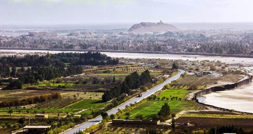
[edit]The town of Laghouat is a regional center in the Algerian depression, an oasis south of Algiers. It is built on the banks of the Wadi Mzee, which flows eastwards from the Amour Range and is one of a large number of seasonal streams that empty into Chott Melrhir.
It is bordered to the north by the municipality of Sidi Makhlouf, to the west by Tadjemout and Kheneg, to the east the municipality of El Assafia, and to the south the municipality of Mekhareg.
Climate
[edit]
Laghouat has a cold desert climate (Köppen climate classification BWk). Rainfall is higher in winter than in summer. The average annual temperature in Laghouat is 17.4 °C (63.3 °F). About 176 mm (6.93 in) of precipitation falls annually. Rain falls irregularly, with severe droughts in some years. Sand dunes may encroach upon the town from the north in drought years, and have been countered with administrative buildings and a green belt of gardens around the city.
The town relies on groundwater, which is abundant due to a large underground dam in Tadjmout, which is the largest of its kind in Africa and dates to the colonial period. It is also known for its mineral water, called milok water, which has attracted investment from a Spanish bottler.
| Climate data for Laghouat | |||||||||||||
|---|---|---|---|---|---|---|---|---|---|---|---|---|---|
| Month | Jan | Feb | Mar | Apr | May | Jun | Jul | Aug | Sep | Oct | Nov | Dec | Year |
| Mean daily maximum °C (°F) | 12.9 (55.2) |
15.5 (59.9) |
18.1 (64.6) |
22.8 (73.0) |
26.8 (80.2) |
32.6 (90.7) |
36.3 (97.3) |
35.3 (95.5) |
30.0 (86.0) |
23.5 (74.3) |
18.1 (64.6) |
13.4 (56.1) |
23.8 (74.8) |
| Mean daily minimum °C (°F) | 2.7 (36.9) |
3.4 (38.1) |
6.0 (42.8) |
8.9 (48.0) |
13.5 (56.3) |
18.4 (65.1) |
21.6 (70.9) |
20.6 (69.1) |
17.1 (62.8) |
11.4 (52.5) |
5.8 (42.4) |
3.4 (38.1) |
11.1 (51.9) |
| Average precipitation mm (inches) | 12 (0.5) |
12 (0.5) |
13 (0.5) |
15 (0.6) |
16 (0.6) |
12 (0.5) |
3 (0.1) |
26 (1.0) |
19 (0.7) |
20 (0.8) |
15 (0.6) |
13 (0.5) |
176 (6.9) |
| Source: Climate-Data.org, Climate data | |||||||||||||
Demographics
[edit]
Most residents of Laghouat Province trace their origins to Berbers and Arabs and neighboring Bedouin tribes that roamed the area. The population was very small due to the relatively isolated nature of the city. In1928 it had 7,000 people, and 11,999 in 1954. After independence in 1962 it was recorded that about 1000 Europeans and 600 Jews departed, but the overall population increased very fast to the economic influx spurred on by the oil and gas industry.[2]
The town had a population of 170,693 people, according to 2012 estimates.
| the year | 1977 | 1987 | 1998 | 2008 | 2012 |
|---|---|---|---|---|---|
| population | 42.186 | 69.435 | 106.665 | 144.747 | 170.693 |
History
[edit]
Early history
[edit]Rock paintings and other archeological evidence indicate that people were living in the area during the Stone Age, from about 9,000 BC. It is believed that climatic change displaced these prehistoric peoples, as it later displaced Roman and Byzantine settlements. The town's location was noted in Roman records on a plateau called Tizgrarin. The inhabitants refused to submit to the Byzantines and convert to Christianity, and resisted paying tribute or taxes to the empires which followed, who sometimes called it a "rebel city".
Medieval and pre-colonial history
[edit]In the 14th century, Ibn Khaldoun reported the existence of a walled town which housed a faction of the "laghouat" tribe (called laghouat-ksel ), a branch of the Berber tribe of the Maghraouas. Over time, the majority of these peoples migrated westward, leaving only two factions in the city: the Berber-descended Sargins and the Ahlaf ("alliance") clans of Arabs. Various nomadic peoples also populated the town at times. In the 1650s the Moroccans established nominal control over the city, and in 1708 they sent out an expedition to create a tributary in Laghouat.[5] [better source needed] The region was taken from the Moroccans, and became a tributary of the Deylik of Algiers in 1727.[6] Other than occasional conflicts they regularly paid tribute annually of biannually to either the Bey of Oran, or the Bey of Titteri until 1828.[7]
French occupation
[edit]The due tribute payment was cut short in 1830, as the Deylik of Algiers collapsed in 1830 following the French invasion of Algiers.[8]
,_huile_sur_toile_,_Titre-_Le_dernier_combat_(_Bataille_de_LAGHOUAT_1852_).jpg)
Laghouat was a center of resistance against French colonial rule from 1831 under Sheikh Moussa Ibn Hassen El Misri. In 1852, France launched a punitive campaign to eradicate the resistance. The Siege of Laghouat began on 21 November and concluded with the storming of the town on 4 December.[9] Several days of brutal massacres followed, which included one of the first recorded uses of chemical weapons on civilians. About two-thirds of the population perished, which became known locally as the Khalya (Arabic: emptiness). It also started a local tradition of protecting young boys from evil with an earring (then done to disguise them as girls).
Other settlements quickly capitulated following the example set at Laghouat, and the French used the town as a gateway for a land route to Sub-Saharan Africa, furthering their colonial ambitions.
During World War II, the Laghouat prison camp held British and Commonwealth servicemen, under the authority of Vichy France. The camp also held a large number of Jews who were described by the French authorities as Communists. Following the war, captured German soldiers were held at the camp.
Post-colonial period
[edit]In January 2012, Laghouat was the site of anti-government protests over improper housing, infrastructure, and treatment of the elderly by police. The police used tear gas to disperse the protesters.[10][11]
Arts and culture
[edit]
Laghouat has a long tradition as a meeting place and cultural center, and has developed handicrafts based around the local raw materials.
In modern times, sand blasting art has emerged in Laghouat. Al-Taher Jadid is a local master of the form.[12]
Traditional dress
[edit]The traditional dress does not differ greatly from what is prevalent in the ancient cities, especially in the steppe and desert region.
As for the man, there are the brannos, the djellaba, the kandoora, the Arab trousers, the innovated “bra” chest, the shirt and the turban, which vary in size and have shrunk over time.
As for what can be mentioned regarding women's clothing, there is what is called “Qanbouz,” which is a serene veil that only protrudes one eye, and it was made of blue and then white cloth, and it had ancient analogues, like other cities, such as the “Fattah veil” and there is the dress, the holly, the protection and the khmer. ..
However, these traditional clothes are almost extinct now for the sake of modern and imported clothes, which necessitates the establishment of a local museum of crafts, traditional clothes and jewelry that will serve history and the balance of developments and social changes and the formation of a civilizational balance that can be taken as a reference to be used in studies and inspired by new creations.
Tourism
[edit]The province has sought to develop tourism with new 4-star hotels, though the existing hotels in Laghouat do not exceed the 3-star rating.
The region is known for its variety of landscapes – mountain valleys, plateaus, plains, sand dunes and steppes – within a small area. Some call it the city of the four seasons, due to the diversity of the terrain.
Landmarks of the town include the old mosque, the fortress of Sidi El Hajj Issa, its shrine, the old quarter, palm groves, and the French colonial cathedral.

The French colonial military fort Tizgraren Tower (also called Buskaran Tower) was opened as a tourist attraction in 2011. It is located at the highest point in the town and dates to 1857. It has four wings, catacombs, and a large square containing the tomb of General Buskaran, who was assassinated within the fort. In the last years of colonization, the tower was converted from a barracks to a military hospital specialized in treating respiratory conditions and allergies. Following Algerian independence, it was used by various security departments.
.
See also
[edit]References
[edit]- ^ "Décret executif n° 91-306 du 24 août 1991 fixant la liste des communes animées par chaque chef de daïra. 03 - Wilaya de Laghouat" [List of municipalities animated by each District chief: 03 - Laghouat Province] (PDF) (in French). Journal officiel de la République Algérienne. 4 September 1991. p. 1294. Retrieved 2019-11-03.
- ^ a b Gibb, H. A. R.; Kramers, J. H. (2008). Shorter Encyclopaedia of Islam. Pentagon Press. pp. 595–597. ISBN 978-81-8274-341-0. OCLC 756316986.
- ^ "Laghouat | Oasis City, Saharan Region, Algeria | Britannica". www.britannica.com. Retrieved 2024-03-05.
- ^ "Synagogue at Laghouat, Algeria | Archive | Diarna.org". archive.diarna.org. Retrieved 2022-11-15.
- ^ Petit, Odette (1976). Laghouat: essai d'histoire sociale (in French). O. Petit.
- ^ Revue tunisienne (in French). Au Secrétariat général de l'Institut de Carthage. 1900.
- ^ Bulletin du comité des travaux historiques et scientifiques: section de géographie (in French). Imprimerie nationale. 1894.
- ^ Abou-Khamseen, Mansour Ahmad (1983). The First French-Algerian War (1830-1848): A Reappraisal of the French Colonial Venture and the Algerian Resistance. University of California, Berkeley.
- ^ "La conquête coloniale de l'Algérie débute le 14 juin 1830". rebellyon.info (in French). Retrieved 2021-05-16.
- ^ "10 injured, several arrested in Algeria protests". Agent France Press. Archived from the original on May 25, 2012. Retrieved 13 January 2012.
- ^ "Anger at squalid housing unleashes Algeria protest". Reuters. Retrieved 13 January 2011.
- ^ Algerian Artist Creates Using "Sanding Technology", BBC Arabic.
- https://www.britannica.com/place/Laghouat, Britannica
- https://www.offshore-technology.com/data-insights/top-ten-natural-gas-producing-fields-in-africa/, Offshore technology
.svg)

Laghouat
View on GrokipediaGeography and Environment
Location and Topography
Laghouat serves as the capital of Laghouat Province in central Algeria, positioned approximately 400 kilometers south of Algiers.[4] [2] The city's geographic coordinates are 33.8°N latitude and 2.88°E longitude.[5] It lies at the interface of the northern Sahara Desert and the Saharan Atlas Mountains, within the Amour Range, marking a transitional zone between steppe and desert landscapes.[6] The topography of Laghouat features a high plateau at an average elevation of 750 meters above sea level, with modest local variations reaching up to 150 meters in difference over short distances.[6] [7] Surrounding elevations include peaks exceeding 2,000 meters in the Saharan Atlas range, contributing to an arid, rugged terrain dominated by rocky outcrops and wadis.[6] This positioning facilitates its role as an oasis settlement, supported by subsurface water sources amid otherwise barren surroundings.[8]Climate and Natural Resources
Laghouat features a hot desert climate classified as BWh under the Köppen system, marked by aridity and significant diurnal temperature swings. Average annual precipitation totals around 75 millimeters, concentrated in sporadic winter events, with prolonged dry spells dominating the year. Daytime highs routinely surpass 40°C in summer, while nocturnal lows can drop below freezing in winter, reflecting the region's continental influence and elevation of approximately 767 meters.[9][10] The hottest month, July, records average highs of 37.2°C, whereas January sees lows averaging 4.5°C, underscoring the stark seasonal contrasts typical of Saharan margins. Relative humidity remains low year-round, averaging below 50%, which exacerbates evaporation rates and limits vegetation to drought-resistant species in surrounding steppes and oases. Dust storms, known locally as sirocco, periodically intensify aridity and impact visibility and air quality.[11] Natural resources in the Laghouat area center on hydrocarbons, with the Hassi R'Mel gas field, situated roughly 50 kilometers south, representing Algeria's premier natural gas reservoir and one of the world's largest. This Triassic formation yields an annual capacity approaching 100 billion cubic meters, bolstering national energy exports and local infrastructure development. Recent initiatives, such as a $2.33 billion project launched in December 2024, aim to counteract depletion and sustain output at 188 million cubic meters daily.[12][13][14] Water resources are constrained, drawing from non-renewable brackish aquifers in southern sedimentary basins, which support limited oasis agriculture and urban needs amid overexploitation risks. Mineral springs, including those yielding locally valued waters, provide supplementary sources but insufficiently offset the scarcity inherent to the desert environment. No significant metallic minerals or phosphates are exploited locally, with economic reliance skewing toward gas extraction over surface renewables or arable land.[15]History
Early and Medieval Foundations
The oasis of Laghouat, historically termed al-Aghwāt, is referenced in 10th-century Arabic sources as an area submitting to the Fatimid caliphate, marking one of the earliest documented interactions with centralized Islamic authority in the Algerian interior. This submission likely involved tribute or nominal allegiance from local pastoralist groups exploiting the site's groundwater for sparse settlement and herding. Settlement expanded in the 11th century amid the Fatimid-orchestrated migrations of Banū Hilāl Arab Bedouin tribes into the Maghreb, aimed at punishing the Zirid dynasty's schism from Shiʿi doctrine; these invasions disrupted sedentary structures and facilitated Arab tribal implantation across steppe and pre-Saharan zones, including oases like Laghouat.[16] Regional clans, such as the Bu ʿAkkaz who traced descent to the Riyah subtribe of Banū Hilāl, exemplify this demographic shift, blending nomadic Arab lineages with preexisting Berber elements in a pattern of conquest, intermarriage, and resource competition characteristic of post-invasion stabilization.[16] During the medieval era, Laghouat functioned as a fortified nodal point on caravan routes linking the Algerian Tell to the Sahara, sustaining itself through date palm cultivation on approximately 253 hectares of irrigable land and pastoralism amid Zenata Berber and Arab tribal rivalries under successive regimes including the Almohads and Zayyanids. By the late 16th century, the settlement paid tribute to the Saʿdian sultans of Morocco, underscoring its peripheral status as a self-governing oasis intermittently drawn into trans-Maghribi power networks without deeper administrative integration.[17] Sparse records reflect the challenges of documenting remote Saharan-edge polities, where oral genealogies and occasional chronicler notations prevailed over archival continuity.Ottoman Rule and Pre-Colonial Dynamics
Laghouat operated under the nominal suzerainty of the Ottoman Regency of Algiers from the 16th century onward, though effective control remained limited in this remote Saharan outpost. The regency's administrative division into three beyliks—Constantine in the east, Titteri in the center, and Oran in the west—facilitated governance, with Laghouat falling within the purview of the Beylik of Titteri, based in Médéa. As a southern frontier settlement, the town contributed taxes to the beylik, reflecting tributary relations rather than direct administration.[18] By 1786, Ottoman authorities more assertively incorporated Laghouat into the Beylik of Titteri, establishing firmer oversight amid efforts to consolidate peripheral territories. Local governance relied on alliances with dominant Arab tribes, notably the Chaamba confederation, whose nomadic warriors controlled the surrounding steppes and protected caravan trade routes linking northern Algeria to sub-Saharan markets. These tribes, descended from Banu Sulaym migrants, maintained semi-autonomous power structures, negotiating with beylical officials while defending against external threats.[2][19] Pre-colonial dynamics underscored the fragility of centralized authority in the region, marked by recurrent raids and shifting allegiances. Moroccan forces under Sultan Ismail Ibn Sharif conducted expeditions against Laghouat from 1708 to 1713, exploiting Ottoman weaknesses to assert influence over Saharan oases. Subsequent rebellions, such as the 1727 uprising supported by the Regency of Algiers, highlighted local resistance to foreign incursions and the interplay between tribal autonomy and intermittent Ottoman intervention. The ksar's fortified architecture and oasis economy sustained its role as a vital nodal point, yet tribal confederations like the Chaamba ensured that power remained decentralized until the onset of French expansion.[20]French Conquest and Colonial Administration (1852–1962)
French forces under General Aimable Pélissier captured Laghouat on December 4, 1852, following a siege that marked a key episode in the pacification of Algeria's Sahara region.[21] Pélissier commanded an expeditionary force of approximately 6,000 troops, which besieged the oasis city defended by local Arab and Berber fighters under Sheikh Bouzian.[21] The assault resulted in heavy casualties among the defenders, with estimates indicating around 3,600 of Laghouat's roughly 6,000 inhabitants killed, including through suffocation in caves using smoke or early chemical agents like chloroform, though accounts of the latter remain debated among historians.[22] [23] Post-conquest, French authorities fortified Laghouat as a military outpost to secure control over the northern Sahara trade routes and prevent resistance incursions from deeper desert tribes.[24] A permanent garrison was established, transforming the ksar into a fortified administrative hub with barracks, supply depots, and defensive walls that integrated European military architecture into the traditional mud-brick structures.[25] This development facilitated the extension of French influence southward, enabling further expeditions to sites like Ouargla in 1854. By the early 20th century, Laghouat served as the administrative center for one of the Territoires du Sud, formalized in 1902 as a subdivision of French Algeria encompassing the Sahara under military governance to manage vast arid expanses with minimal civilian oversight.[26] Colonial administration emphasized resource extraction, oasis irrigation improvements, and limited European settlement, though the harsh climate restricted large-scale colonization compared to northern Algeria.[24] Infrastructure projects, including roads and wells, supported military logistics and modest economic activities like date cultivation, while suppressing local autonomy through direct rule.[27] Throughout the colonial era until Algerian independence in 1962, Laghouat remained a strategic garrison town, experiencing periodic unrest but also emerging as a center for Muslim reformist movements by the 1920s, reflecting tensions between assimilation policies and indigenous cultural revival.[22] French governance prioritized security and extraction over broad development, contributing to demographic shifts and architectural legacies that persist in the urban fabric.[24]Role in Algerian Independence War
During the Algerian War of Independence (1954–1962), Laghouat, located in the northern Sahara, served as a peripheral but symbolically significant hub of resistance amid the Front de Libération Nationale (FLN)'s broader guerrilla campaign, which primarily focused on northern urban and mountainous regions. The city's pre-war status as a stronghold of the Association of Algerian Muslim Ulama's reformist movement, active since 1927, fostered Islamist-nationalist sentiments that aligned with FLN ideology, providing ideological and grassroots support for mobilization in the southern territories.[17] This reformist influence, emphasizing cultural revival and anti-colonial education, contributed to recruiting locals into FLN networks, though direct combat in Laghouat city remained limited due to French administrative control and military presence in the oasis.[17] A notable engagement occurred on October 3, 1956, in the El-Ghicha region of Laghouat province, where FLN combatants ambushed and clashed with French colonial forces in the Battle of El-Khotifa, marking one of the early southern "epics" of the revolution.[28] The battle highlighted the FLN's ability to extend operations into desert fringes, disrupting French supply lines and demonstrating tribal alliances in the area, though specific casualty figures remain undocumented in available records. French responses included intensified patrols and infrastructure fortification around Laghouat to counter such hit-and-run tactics, reflecting the war's shift toward counterinsurgency in remote zones by the late 1950s. Laghouat's strategic position facilitated limited FLN propaganda and logistics efforts, including operations from regional centers that broadcast revolutionary messaging southward.[29] By the war's end in 1962, following the Évian Accords on March 18, local participation underscored the nationwide scope of the independence struggle, transitioning Laghouat from colonial outpost to provincial capital in the new Algerian state, though southern fronts like this saw fewer resources than Wilaya I (Aurès) or urban battles in Algiers.[30]Post-Independence Era and Governance Challenges
Following Algerian independence on July 5, 1962, Laghouat transitioned from French colonial administration to national control, with the departure of approximately 1,000 Europeans and 600 Jews creating vacant housing that local residents rapidly occupied, spurring unplanned urban expansion and the emergence of informal settlements.[24] This shift exacerbated housing pressures in the oasis town, as population growth outpaced infrastructure development, leading to high-density quarters like Essadikia, where subsequent regularization efforts have struggled to address overcrowding and service deficits. The national government's centralized planning model prioritized northern industrial hubs, leaving southern regions like Laghouat with limited local autonomy and reliance on state directives for resource allocation.[31] In 1984, Laghouat was elevated to wilaya (province) status amid Algeria's administrative reorganization, enhancing its regional governance framework but reinforcing central oversight through appointed walis (governors).[32] Educational infrastructure advanced with the establishment of a university center in 1986, which gained full university status in 2001 as Université Amar Telidji, focusing initially on engineering disciplines to support local technical needs amid the country's push for self-reliance.[33] However, the 1990s civil war disrupted progress, with Islamist militants active in the area; for instance, eleven civilians were killed near Laghouat on December 2, 1999, highlighting the region's vulnerability to national instability.[34] Governance challenges persist due to Algeria's highly centralized system, where local institutions in Laghouat face financial dependency on Algiers, limiting responsive budgeting for water scarcity, desertification, and unemployment in this arid steppe zone.[35] Southern marginalization fuels periodic protests, as seen in broader Saharan unrest over unequal hydrocarbon wealth distribution—despite nearby fields, Laghouat derives limited direct benefits—and inadequate infrastructure, with the national oil price slump since 2014 amplifying fiscal strains on regional development.[36][37] Urban sustainability efforts, including heritage preservation in the ksar (fortified quarter), contend with colonial-era legacies and informal growth, underscoring the need for decentralized reforms to mitigate social tensions and enhance local resilience.[24][38]Demographics and Society
Population Dynamics
The population of Laghouat city grew from 107,273 inhabitants in the 1998 census to 144,747 in the 2008 census, yielding an average annual increase of 3.1%.[39] This expansion outpaced the national average during the period, reflecting the city's role as a regional hub in the Algerian Sahara.[39] Similarly, Laghouat Province's population rose from 327,634 in 1998 to 455,602 in 2008, with a density of 18 persons per square kilometer.[40] Growth was propelled by natural increase and net in-migration, as economic prospects in nearby natural gas fields, such as Hassi R'Mel, drew workers from rural and nomadic communities.[39]| Census Year | City Population | Province Population |
|---|---|---|
| 1998 | 107,273 | 327,634 |
| 2008 | 144,747 | 455,602 |