
Community hub
Recent from talks
Contribute something
Nothing was collected or created yet.
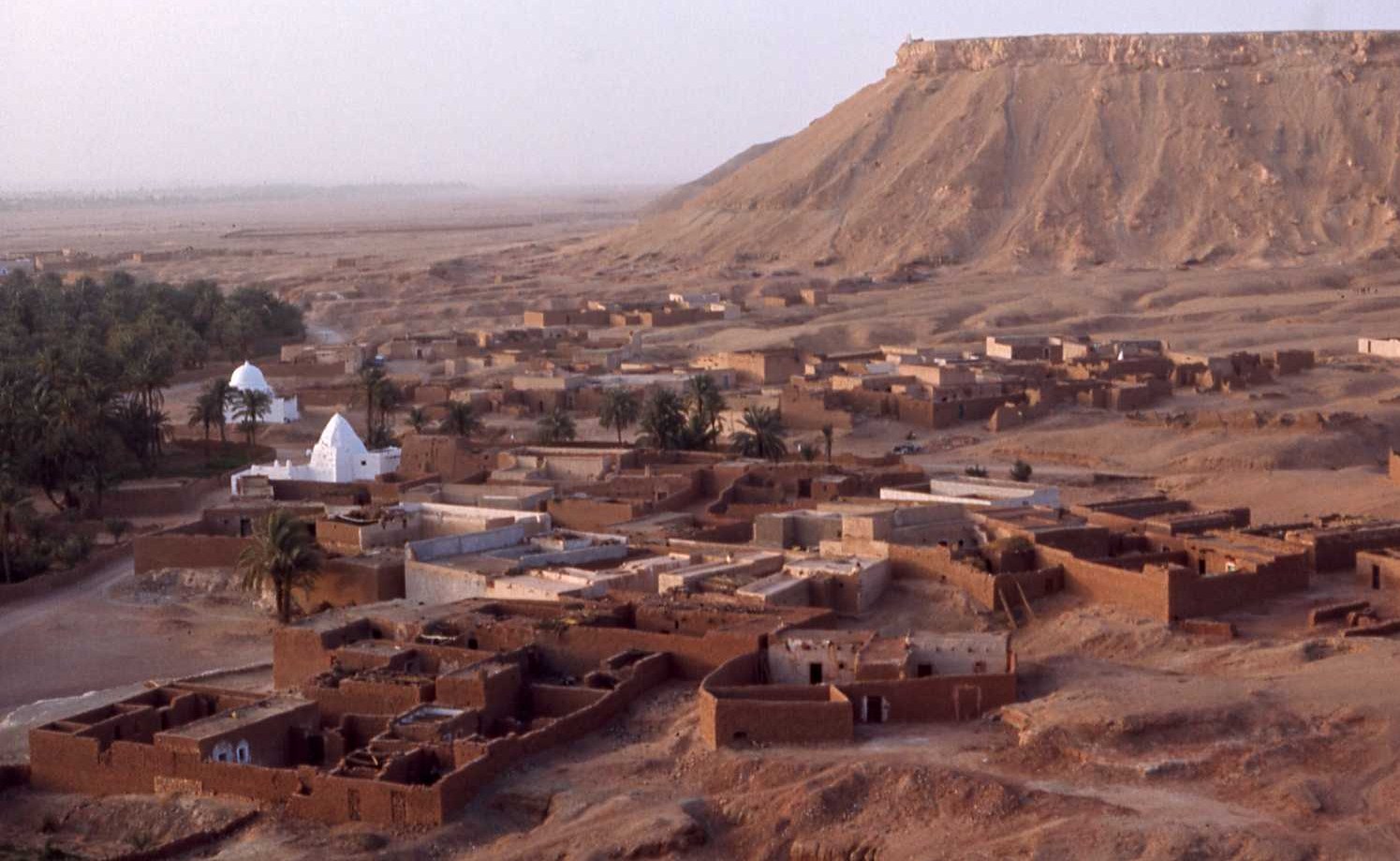
El Menia
View on WikipediaEl Menia (Arabic: المنيعة) is an oasis town and commune, and capital of El Ménia District, in the homonymous El Menia Province, Algeria. The former name is El Goléa (Arabic: القليعة); together in Arabic, the two names mean Impregnable Castle.[2] According to the 2008 census it has a population of 40,195,[1] up from 28,848 in 1998,[3] with an annual growth rate of 3.4%.[1] The area is inhabited by the Zenete Berbers. El Menia oasis grows many agricultural products. The grave of the French priest Charles de Foucauld is located in the town.
Key Information

.svg)

Geography
[edit]El Menia is located almost at the center of Algeria, lying at the eastern border of the Grand Erg Occidental at an elevation of 380 metres (1,250 ft). The town is a gateway to the Sahara in the south, and has an estimated 180,000 palm trees within the oasis area.[citation needed] The oasis itself lies beneath an escarpment rising up to 200 metres (660 ft) above. Some of the largest continuous areas of Saharan sand dunes begin just a few kilometres to the west of the oasis.
Climate
[edit]El Menia has a hot desert climate (Köppen climate classification BWh), with long, extremely hot summers and short, warm winters. There is very little rain throughout the year, and summers are especially dry. Summer daytime temperatures are known to consistently approach 45 °C (113.0 °F). The sky is clear throughout the year and sunny, bright days are guaranteed. On July 7, 2021, the record high temperature of 49.1 °C (120.4 °F) was registered.[4]
| Climate data for El Menia (El Golea Airport) 1991–2020 | |||||||||||||
|---|---|---|---|---|---|---|---|---|---|---|---|---|---|
| Month | Jan | Feb | Mar | Apr | May | Jun | Jul | Aug | Sep | Oct | Nov | Dec | Year |
| Record high °C (°F) | 27.5 (81.5) |
36.5 (97.7) |
38.2 (100.8) |
43.0 (109.4) |
44.2 (111.6) |
46.6 (115.9) |
49.1 (120.4) |
48.0 (118.4) |
46.4 (115.5) |
42.1 (107.8) |
33.8 (92.8) |
29.5 (85.1) |
49.1 (120.4) |
| Mean daily maximum °C (°F) | 17.5 (63.5) |
20.1 (68.2) |
— | 29.5 (85.1) |
34.6 (94.3) |
39.6 (103.3) |
42.8 (109.0) |
41.8 (107.2) |
37.4 (99.3) |
30.8 (87.4) |
23.1 (73.6) |
18.3 (64.9) |
— |
| Daily mean °C (°F) | 10.1 (50.2) |
12.4 (54.3) |
16.9 (62.4) |
21.5 (70.7) |
26.6 (79.9) |
31.5 (88.7) |
34.6 (94.3) |
33.8 (92.8) |
29.9 (85.8) |
23.4 (74.1) |
15.8 (60.4) |
11.2 (52.2) |
22.3 (72.1) |
| Mean daily minimum °C (°F) | 2.6 (36.7) |
4.7 (40.5) |
8.9 (48.0) |
13.6 (56.5) |
18.6 (65.5) |
23.3 (73.9) |
26.3 (79.3) |
25.9 (78.6) |
22.4 (72.3) |
16.1 (61.0) |
8.4 (47.1) |
4.1 (39.4) |
14.6 (58.3) |
| Record low °C (°F) | −5.5 (22.1) |
−4.6 (23.7) |
−2.2 (28.0) |
4.0 (39.2) |
8.5 (47.3) |
12.2 (54.0) |
20.0 (68.0) |
18.2 (64.8) |
11.8 (53.2) |
4.9 (40.8) |
−1.8 (28.8) |
−4.5 (23.9) |
−9.4 (15.1) |
| Average precipitation mm (inches) | 6.6 (0.26) |
1.8 (0.07) |
7.2 (0.28) |
2.9 (0.11) |
2.4 (0.09) |
0.4 (0.02) |
0.0 (0.0) |
0.7 (0.03) |
5.5 (0.22) |
4.7 (0.19) |
4.6 (0.18) |
4.1 (0.16) |
40.9 (1.61) |
| Average precipitation days (≥ 1.0 mm) | 0.9 | 0.4 | 0.9 | 0.4 | 0.5 | 0.2 | 0.0 | 0.2 | 0.8 | 0.8 | 0.9 | 0.7 | 6.7 |
| Source: NOAA[5] | |||||||||||||
Transportation
[edit]El Menia has good road connections along the N1 highway to Ghardaïa to the north and In Salah to the south. El Golea Airport is located 3 kilometres (1.9 mi) west of the town's center.
Education
[edit]6.9% of the population has a tertiary education, and another 17.3% has completed secondary education.[6] The overall literacy rate is 81.4%, and is 85.4% among males and 77.2% among females.[7]
-
 The old ksar.
 -
 Public National Museum of El Menia.
 -
 St. Joseph Church
 -
 Grave of Charles de Foucauld.
.jpg)

_01.jpg)

Localities
[edit]The commune of El Menia is composed of 12 localities:[8]
- Centre-ville
- Taghit
- Belbachir
- Hoffrat El Abbas
- Vieux Ksar
- Badriane
- Belaïd
- Zouitel
- Ouled Zid
- Tin Bouzid
- Ksar Belkacem
- Ouled Feradj
References
[edit]- ^ a b c "Population: Ghardaïa Wilaya" (PDF) (in French). Office National des Statistiques Algérie. Archived from the original (PDF) on 16 May 2013. Retrieved 13 February 2013.
- ^ . Encyclopædia Britannica. Vol. VIII (9th ed.). 1878. p. 133.
- ^ "Algeria Communes". Statoids. Retrieved 9 March 2013.
- ^ "60590: El Golea (Algeria)". ogimet.com. OGIMET. 7 July 2021. Retrieved 8 July 2021.
- ^ "El Golea Climate Normals 1991–2020". World Meteorological Organization Climatological Standard Normals (1991–2020). National Oceanic and Atmospheric Administration. Retrieved 26 September 2023.
- ^ "Structure relative de la population résidente des ménages ordinaires et collectifs âgée de 6 ans et plus selon le niveau d'instruction et la commune de résidence" (PDF) (in French). Office National des Statistiques Algérie. Archived from the original (PDF) on 16 May 2013. Retrieved 13 February 2013.
- ^ "Taux d'analphabétisme et taux d'alphabétisation de la population âgée de 15 ans et plus, selon le sexe et la commune de résidence " (PDF) (in French). Office National des Statistiques Algérie. Archived from the original (PDF) on 16 May 2013. Retrieved 13 February 2013.
- ^ "Décret n° 84-365, fixant la composition, la consistance et les limites territoriale des communes. Wilaya d'El Oued" (PDF) (in French). Journal officiel de la République Algérienne. 19 December 1984. p. 1579. Archived from the original (PDF) on 2013-04-12. Retrieved 2 March 2013.
Places adjacent to El Menia | |
|---|---|

.svg)
El Menia
View on GrokipediaHistory
Early Settlement and Oasis Development
The Zenata Berbers, a prominent confederation of nomadic and semi-nomadic tribes, established the early settlement of El Goléa (now El Menia) during the Middle Ages, founding the original ksar known as Taurirt, meaning "little castle" in Berber. This fortified hilltop structure served as a defensive outpost amid the harsh Saharan landscape, reflecting the Zenata's adaptation to the desert environment through communal architecture designed for protection against raids and environmental extremes. Traditional accounts, drawing from historical chronicles, portray the ksar as a foundational hub that evolved from temporary encampments into a permanent oasis community, emphasizing the Berbers' ingenuity in harnessing limited resources for survival.[10] The development of extensive palm groves became a cornerstone of the oasis's economy and sustenance, transforming El Goléa into a vital agrarian center by the medieval period. Date palms, cultivated intensively around the settlement, provided essential food, shade, and materials, with the groves forming a green belt that supported both local inhabitants and passing traders. These plantations, estimated at approximately 180,000 trees covering hundreds of hectares, underscored the oasis's role as a self-sustaining enclave, where Berber farmers employed terracing and selective irrigation to combat aridity and ensure year-round productivity.[10] Historically referred to as El Goléa—derived from the Arabic al-Qulayʿa, signifying a "little fortress" or impregnable stronghold—the site functioned as a critical stopover on trans-Saharan caravan routes linking northern Algeria to regions like the Mzab, Tuat, and Tidikelt. Nomadic groups, including the Shaʿanba, utilized it as a trade entrepôt for exchanging goods such as dates, salt, and textiles, facilitating commerce that bolstered the local economy through the 17th century under governors appointed by the Wargla sultanate. Archaeological remnants of the ksar and traditional oral histories highlight its strategic position, which allowed control over vital water points and protected pathways for camel caravans traversing the desert.[10][11] Early water management in El Goléa relied on artesian wells tapping into the Wadi Seggur aquifer, a system that predated modern interventions and enabled the irrigation of palm groves without surface evaporation losses. Traditional Berber practices, as documented in medieval accounts, involved communal maintenance of these wells to distribute water equitably, preventing overuse in the arid setting. While foggaras (underground channels) were prevalent in nearby Saharan oases for groundwater capture, El Goléa's reliance on natural artesian flow distinguished its hydraulic heritage, sustaining settlement growth until European influences began in the 19th century.[10][12]Colonial Era and Post-Independence Growth
The French occupation of the oasis, then known as El Goléa, began in 1873 under General Gaston Alexandre Auguste de Gallifet, who led forces to secure the site as a strategic military outpost in the Algerian Sahara to control trade routes and counter local resistance. During the colonial period, El Goléa served as a key garrison town, with permanent French troops stationed there to maintain order amid the expanding Saharan frontier, including fortifications that supported broader imperial control over southern Algeria.[13] A notable landmark from this era is the grave of Charles de Foucauld, the French priest and explorer who died in 1916; his remains were interred at the Christian Cemetery of St. Joseph Church in El Goléa, symbolizing the intersection of missionary efforts and colonial presence. During the Algerian War of Independence from 1954 to 1962, El Goléa functioned primarily as a French military base in the remote Sahara, facilitating logistics and surveillance rather than being a central theater of combat, though earlier internment of nationalists like Messali Hadj there in 1945 highlighted its role in suppressing independence movements.[14] Local resistance events were limited due to the area's isolation and heavy garrisoning, but the town's strategic position contributed to French efforts to secure the southern territories against FLN operations.[15] Following Algeria's independence in 1962, the new government implemented nationalization of lands formerly held by French settlers, including in Saharan oases like El Goléa, as part of broader agrarian reforms to redistribute property and promote self-management in agriculture.[16] The town was integrated into Ghardaïa Province, where it remained until administrative restructuring elevated its status. In 2019, El Menia Province (formerly El Méniaa) was established as a full wilaya, with the town designated as its capital, formalizing its role in regional governance after a period as a delegated wilaya since 2015.[17] Post-independence growth was marked by infrastructure investments that spurred population increases, with the commune's residents rising from 28,848 in the 1998 census to 40,195 in 2008, reflecting improved access to water, roads, and services in the oasis region. These developments built on the oasis's agricultural foundations, enhancing connectivity and economic viability in the post-colonial era.Geography and Environment
Location and Topography
El Menia is situated in central Algeria, approximately 267 kilometers southwest of Ghardaïa, at the eastern edge of the Grand Erg Occidental, one of the largest sand seas in the Sahara Desert. The town lies at an elevation of 380 meters above sea level, with geographic coordinates around 30°35′N 2°53′E.[18] This positioning places it within the vast Saharan interior, where the landscape transitions from rocky plateaus to expansive dune fields. The town serves as the central commune of El Menia Province (Wilaya d'El Menia), which spans an area of 55,870 square kilometers and is bordered to the north by Ghardaïa Province, to the south by Aïn Salah Province, to the east by Ouargla Province, and to the west by Timimoun Province.[19] The province encompasses diverse desert terrains, with El Menia acting as the administrative and settlement hub, facilitating connectivity via National Route N1. Topographically, El Menia is characterized by a relatively flat Saharan relief interrupted by plateaus and depressions, with an escarpment rising up to 200 meters above the oasis to the north and surrounding sand dunes extending westward into the Grand Erg Occidental.[18] Seasonal wadis, such as those channeling intermittent water flows, traverse the area, influencing historical and modern settlement patterns by concentrating human activity around natural water-retaining depressions that support oasis vegetation.[20] These features create a mosaic of hamadas (stony plateaus) and ergs (dune seas), shaping the region's sparse and adaptive habitation.Oasis Features and Climate
El Menia sustains its oasis ecosystem through underground aquifers that supply vital water to expansive palm groves and vegetable gardens, forming the backbone of the region's greenery amid the surrounding Sahara Desert. These aquifers are accessed via the traditional foggara system, a network of gently sloping underground galleries that transport groundwater over long distances to surface canals for irrigation, a practice dating back centuries and essential for combating aridity. This hydraulic infrastructure not only nourishes date palms and other crops but also supports small-scale horticulture, creating fertile pockets in an otherwise barren landscape.[21][22] The climate of El Menia is classified as a hot desert type (Köppen BWh), characterized by extreme aridity and intense solar radiation. Annual precipitation averages 36 mm, concentrated primarily in the winter months from December to February, with the remainder of the year experiencing virtually no rainfall. Clear skies dominate, delivering around 3,500 hours of sunshine per year, which intensifies the heat and contributes to the oasis's high evaporation rates. The surrounding topographical escarpments offer limited shelter, fostering a microclimate that slightly moderates wind patterns but does little to alleviate overall dryness.[23][23] Temperature extremes define the region's habitability, with summer highs averaging 42°C and occasionally surpassing 45°C during heatwaves, while winter lows dip to about 5°C at night. Diurnal variations routinely exceed 20°C, driven by rapid cooling after sunset due to low humidity and absent cloud cover. These conditions pose significant environmental challenges, including sand encroachment that progressively buries palm groves and erodes arable land, as well as chronic water scarcity from aquifer depletion and erratic rainfall patterns influenced by broader desertification trends.[23][24][25]Demographics
Population Statistics
According to the 2008 Algerian census conducted by the Office National des Statistiques (ONS), the commune of El Menia had a population of 40,195 inhabitants, marking an annual growth rate of 3.4% from the 28,848 residents recorded in the 1998 census. This growth reflects broader trends in Algerian oases, driven by natural increase and internal mobility. An official estimate as of late 2018 places the commune's population at 48,228.[4] For the province, the 2008 census recorded 57,276 inhabitants, with an estimate of 77,361 as of 2018.[26] Projections based on Algeria's national population growth rate of approximately 1.5% annually suggest the commune's population reached about 53,500 and the province's about 86,000 by 2025.[27] The commune exhibits an urban-rural distribution with roughly 70% of residents in urban areas, consistent with Algeria's overall urbanization rate of 74.3% as of 2021. Population density in the province remains low at around 1.4 people per km² as of 2018, given the expansive area of 55,870 km² encompassing desert and oasis terrains.[2] El Menia's demographics feature a youthful profile, with a median age of approximately 23 years, underscoring a population heavily weighted toward younger age groups typical of Algerian demographics.[28] There is a slight male majority, comprising about 51% of the population.[28] Recent migration patterns have included an influx from rural areas and adjacent provinces, accelerated after the 2019 establishment of El Ménia as a separate wilaya, which enhanced administrative and economic opportunities in the region. This internal migration contributes to sustained population growth amid Algeria's broader rural-to-urban shifts.Ethnic and Linguistic Composition
The population of El Menia is predominantly composed of Zenete Berbers, an indigenous Amazigh group native to the region, alongside subgroups such as the Mozabites who trace their heritage to the M'zab Valley settlements.[29] The Chaamba, an Arab Bedouin tribe, also forms a significant presence, historically nomadic and integrated into the oasis's social fabric through intermarriage and shared territorial claims in central Algeria's Sahara.[30] Minority Arab communities, often descendants of historical migrations, coexist with smaller groups of recent sub-Saharan African migrants who have settled amid broader regional transit patterns across the desert routes.[31] Linguistically, Modern Standard Arabic serves as the official language of Algeria, widely used in administration and education, while the local population predominantly speaks Algerian Arabic dialects influenced by Berber substrates.[32] Tamazight, the Berber language encompassing regional variants like the Mozabite dialect in nearby areas, is actively spoken among the Zenete and Mozabite communities, reflecting their cultural continuity in the oasis environment.[33] Religiously, the inhabitants are overwhelmingly Sunni Muslims adhering to the Maliki school, comprising over 99% of Algeria's population, with notable Ibadi influences stemming from the adjacent M'zab Valley's Mozabite traditions.[34] A historical Jewish community, present since the 13th or 14th century in the M'zab oases including nearby Ghardaïa, largely emigrated during the mid-20th century amid Algeria's independence struggles and broader regional upheavals.[35] Socially, community organization in El Menia revolves around tribal affiliations and extended family clans, a structure common to both Berber and Arab groups like the Dui-Menia Bedouins, where kin-based units—ranging from immediate families to larger tribes—mediate disputes, resource sharing, and cultural practices in the arid setting.[6] This clan system fosters cohesion in the oasis's isolated environment, influencing everything from marriage alliances to local governance participation.[36]Economy
Agriculture and Water Resources
Agriculture in El Ménia, a key oasis region in Algeria's El Menia Province, revolves around date palm cultivation as the primary economic activity, supported by limited arable land in the arid desert environment. The wilaya spans approximately 3,181 hectares dedicated to date palms, contributing to the region's status as a significant producer within the broader Saharan agricultural landscape. As of 2025, annual date production in El Ménia is forecast to exceed 18,540 tons across various varieties, harvested from productive palm groves that form the backbone of local farming.[37][38] In addition to dates, oasis irrigation enables the cultivation of vegetables and other crops on smaller scales, utilizing the microclimate created by palm groves to grow items such as potatoes on 201 hectares and watermelons on 450 hectares. These secondary crops complement date farming by providing diversified food production and income sources for local farmers, though they occupy only a fraction of the total useful agricultural area of 21,541 hectares in the wilaya. The overall cultivated land emphasizes cereals and forage, which account for about 50% of arable space, underscoring the integrated oasis agroecosystem.[37] Water management relies on modern systems, with contemporary farming increasingly incorporating borehole-fed pivot irrigation, with farms often equipped with up to 25 wells per site to address water scarcity. Challenges include declining water tables due to intensive extraction and soil salinization, which threaten long-term sustainability in this hyper-arid setting receiving less than 100 mm of annual rainfall.[39] Livestock herding, particularly goats and sheep, supplements agricultural income through pastoral activities in the surrounding steppes, where family-based caprine and ovine operations provide meat, milk, and wool for local consumption. These herds adapt to the steppe environment, with development opportunities identified for expanding caprine and ovine stocks alongside camels and bovines, though numbers remain modest compared to crop production.[37][40] Since the 2000s, the Algerian government has provided subsidies through programs like the National Agricultural Development Plan (PNDA) to promote water-efficient technologies, including drip irrigation systems that reduce consumption by up to 50% in date palm and vegetable fields. These incentives, administered via the Office for Agricultural Development in Saharan Lands (ODAS)—headquartered in El Ménia since 2020 to promote industrial agriculture in desert areas—support the adoption of localized irrigation to combat aridity and enhance productivity in El Ménia's expanding agricultural perimeters. A national program (2023-2027) aims to plant one million date palms nationwide to boost production and exports.[41][42][43][44] El Ménia's date output contributes to Algeria's national exports, with the country producing over 1 million tons annually and exporting around 67,000 tons in 2024, bolstering its position as a top global producer. Harvesting relies on seasonal labor patterns, involving family workers supplemented by temporary migrants during pollination and picking seasons, which peak in autumn and generate short-term employment for hundreds in the oasis communities.[45][46]Trade and Modern Industries
El Ménia functions as a regional trade hub in the Algerian Sahara, facilitating commerce through local markets that connect oasis communities with broader networks. Historically known as El Goléa, the town served as a key stop along trans-Saharan caravan routes, where traders exchanged goods such as salt, textiles, and livestock. Today, weekly souks in El Ménia draw vendors and buyers from surrounding areas, offering dates, traditional crafts, and imported consumer items like clothing and household goods.[47] Small-scale industries in El Ménia center on processing local agricultural output and artisanal production. Date processing plants handle the region's abundant palm harvests, transforming fresh dates into packaged products for domestic sale and export, supporting the town's economy alongside traditional farming. Handicrafts, including pottery decorated with geometric Berber motifs and woven textiles, are crafted by local artisans, reflecting Zenete Berber heritage and contributing to cultural preservation efforts. The Direction of Tourism and Handicrafts El Meniaa promotes these activities to bolster local livelihoods.[19][7] Tourism represents an emerging sector with significant potential, centered on the town's lush oases and historical sites. The grave of Charles de Foucauld, the French priest and explorer who lived in the region, serves as a pilgrimage site, attracting spiritual visitors and history enthusiasts to the Saint Joseph Church and surrounding palm groves. Combined with desert excursions and the fortified ksar architecture, these attractions highlight El Ménia's role as a gateway to Saharan heritage, though development remains modest due to remote location.[47][7][48] Agricultural products, particularly dates, provide the foundational base for El Ménia's trade activities, linking primary production to market exchanges.Government and Administration
Local Governance
El Menia operates as a commune and serves as the provincial capital of El Menia Province (wilaya) within Algeria's decentralized administrative framework. As a commune, it is governed by the Assemblée Populaire Communale (APC), an elected deliberative body responsible for local decision-making on urban planning, public services, and community development. The president of the APC, who acts as the commune's mayor, is elected by the assembly members following direct elections held every five years. This structure aligns with Algeria's 2012 organic law on communes, which enhanced local autonomy by mandating universal suffrage for APC composition.[49] At the provincial level, El Menia Province, elevated to full wilaya status in December 2019, is headed by a wali appointed by the President of Algeria to represent central authority and coordinate development initiatives. The wali, currently Mr. Mukhtar Bin Malik, oversees executive functions, including the implementation of national policies tailored to the region's arid environment. Supporting the wali is the Assemblée Populaire Wilayale (APW), an elected body that deliberates on provincial matters such as budgeting and infrastructure priorities, with elections synchronized to national cycles.[50][51] Key local policies emphasize combating desertification through afforestation and soil conservation efforts, integrated with national programs like the Green Dam initiative, which aims to halt Saharan encroachment in southern wilayas. Infrastructure development receives substantial funding from the national budget, supporting projects such as new public facilities and urban extensions to improve connectivity and living standards in oasis localities. The province receives funding for infrastructure projects focused on essential services amid environmental challenges.[52] The 2021 local elections marked a significant political event, with the APC and APW renewed amid broad participation from the province's diverse population, including the Zenete Berber communities predominant in the area. These elections, held on November 27, reinforced local representation and aligned with national reforms promoting inclusive governance in remote southern regions.[53]Administrative Divisions and Localities
El Menia Province is administratively structured as a single daïra, known as the El Menia District, which comprises three communes: El Menia, Hassi Fehal, and Hassi Gara.[2] This organization reflects the province's establishment as a full wilaya in December 2019, evolving from its prior status as a delegated wilaya created in 2015, with boundary adjustments to delineate its 55,870 km² territory from neighboring provinces.[2][17] The communes vary in function, with the urban-oriented El Menia commune acting as the administrative and commercial hub, overseen by a communal assembly, while the rural Hassi Fehal and Hassi Gara communes emphasize pastoralism and oasis-based livelihoods.[2][17] According to the 2008 census (note: more recent data available in demographics section), these units had populations of 40,195 in El Menia, 17,801 in Hassi Gara, and 3,651 in Hassi Fehal, illustrating a range from urban density to sparse rural settlement.[54]| Commune | Population (2008 Census) | Primary Function | Area Contribution (approx.) |
|---|---|---|---|
| El Menia | 40,195 | Administration and urban services | Central oasis core |
| Hassi Gara | 17,801 | Rural pastoralism | Northeastern extensions |
| Hassi Fehal | 3,651 | Rural pastoralism | Southwestern extensions |