Hubbry Logo
ORiNOCOORiNOCOMain
Open search
ORiNOCO
Community hub
ORiNOCO
logo
8 pages, 0 posts
0 subscribers
Be the first to start a discussion here.
ORiNOCO
ORiNOCO
from Wikipedia
Chipsets

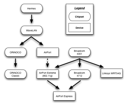
ORiNOCO was the brand name for a family of wireless networking technology by Proxim Wireless (previously Lucent). These integrated circuits (codenamed Hermes) provide wireless connectivity for 802.11-compliant Wireless LANs.

Variants

[edit]
ORiNOCO Silver PC card

Lucent offered several variants of the PC Card, referred to by different color-based monikers:

  • White/Bronze: WaveLAN IEEE Standard 2 Mbit/s PC Cards with 802.11 support.
  • Silver: WaveLAN IEEE Turbo 11 Mbit/s PC Cards with 802.11b and 64-bit WEP support.
  • Gold: WaveLAN IEEE Turbo 11 Mbit/s PC Cards with 802.11b and 128-bit WEP support.

Later models dropped the 'Turbo' moniker due to 802.11b 11 Mbit/s becoming widespread.

Proxim, after taking over Lucent's wireless division, rebranded all their wireless cards to ORiNOCO - even cards not based on Lucent/Agere's Hermes chipset. Proxim still offers ORiNOCO-based cards under the 'Classic' brand.

Rebranded products

[edit]

The WaveLAN chipsets that power ORiNOCO-branded cards were commonly used to power other wireless networking devices, and are compatible with a number of other access points, routers and wireless cards. The following brand and models utilise the chipset, or are rebrands of an ORiNOCO product:

[3]

Preferred wireless chipset for wardriving

[edit]

The ORiNOCO (and their derivatives) is preferred by wardrivers, due to their high sensitivity and the ability to report the level of noise (something that other chips of the era did not report). The pre-Proxim (or 'Classic') ORiNOCO cards have a jack for attaching an external antenna.[4]

Linux drivers

[edit]

A Linux Orinoco Driver supported the IEEE 802.11b Hermes/ORiNOCO family of chips. It was included in the Linux kernel from version 2.4.3[5] until its removal in 6.8.[6]

References

[edit]
[edit]
Revisions and contributorsEdit on WikipediaRead on Wikipedia
from Grokipedia
The Orinoco River is a major waterway in northern , one of the longest rivers on the continent at approximately 2,140 kilometers (1,330 miles; measurements vary), originating from springs in the Parima Mountains of the Guiana Highlands near the -Brazil border and flowing in a broad arc primarily through before emptying into the Atlantic Ocean via a vast delta in eastern , adjacent to Trinidad. Its spans about 880,000 square kilometers (340,000 square miles), encompassing roughly 65% of Venezuelan territory and 35% of Colombian, with the river serving as a critical hydrological connector between the Andean slopes and the . The Orinoco discharges an average of over 35,000 cubic meters per second—ranking third globally in volume after the Amazon and Congo rivers—and transports immense sediment loads that shape its delta and coastal ecosystems. The river's basin features diverse physiography, including savannas, rainforests, and wetlands, with major tributaries like the Meta, , and Guaviare contributing to its high water yield driven by seasonal rainfall patterns that peak from to . Ecologically, the Orinoco supports one of the world's richest freshwater systems, harboring over 1,000 fish species (including iconic ones like the ), the endangered , thousands of plant varieties, and migratory birds, while its floodplains sustain vital carbon storage and nutrient cycling. Significant human populations rely on the river for transportation, , , and , with the delta region hosting indigenous communities whose livelihoods intertwine with its rhythms. Despite its abundance, the Orinoco faces pressures from , , and climate variability, which threaten its flow regime and , underscoring the need for transboundary conservation efforts between and . Historically explored by figures like in the early 19th century, the river remains a cornerstone of regional identity and scientific study for its role in sediment dynamics and inter-basin connections, such as the linking it to the Amazon.

Etymology

Name Origin

The name "Orinoco" originates from the , spoken by inhabiting the river's delta region in eastern and western , where it derives from the terms wiri (meaning "where we paddle") and noko (meaning "place"), collectively signifying "a place to paddle" or a navigable suited for canoe travel. This etymology reflects the Warao's deep cultural reliance on the river for transportation and livelihood, as their autonym "Warao" itself translates to "canoe people" or "boat people." The first European sighting of the Orinoco's mouth occurred on August 1, 1498, during Christopher Columbus's third voyage, when he approached the delta's outlets from the and mistook the expansive, branching waterways for the entrance to a large gulf or separating an from the mainland. Columbus did not record the indigenous name at the time but instead applied Spanish designations to nearby features, such as naming one of the delta's northern branches "Rio de Gracia" (River of Grace) after anchoring there on August 10, 1498. Over the following centuries, European cartographers and explorers gradually adopted and adapted the indigenous term into forms like "Orynoque" and "Orinoque" (also spelled "Oronoque") in 16th-century Spanish maps and accounts, evolving toward the modern spelling "Orinoco" by the as the river's full extent became better documented. This linguistic transition preserved the Warao root while integrating it into colonial , emphasizing the river's role as a vital navigable .

Historical and Alternative Names

The Spanish colonial adaptation of the river's name emerged as "Río Orinoco" during early explorations, with the term first documented in accounts of expeditions seeking . In 1531, Spanish explorer Diego de Ordaz led the initial recorded voyage up the river from its delta, navigating approximately 1,000 kilometers to the Meta River confluence, where the name "Orinoco" was applied based on indigenous designations encountered along the route. Indigenous groups provided various alternative names reflecting the river's characteristics, such as Paragua, denoting its extensive flooding of surrounding lands. In modern usage, the official name remains Río Orinoco in both and , where it serves as a shared international boundary and waterway. Bilingual contexts occasionally incorporate indigenous terms in cultural or educational materials, such as Warao references in Venezuelan delta communities, though Spanish predominates in official documents and .

Geography

Physical Course and Dimensions

The Orinoco River measures approximately 2,140 km (1,330 mi) in length, making it one of the longest rivers in . It originates in the Sierra Parima mountains within the Guiana Highlands, near the border between and , at an elevation of about 1,000 m above sea level. From this highland source, the river descends with a total elevation drop of roughly 1,000 m over its course, facilitating its flow through diverse terrains to sea level at the Atlantic Ocean. The river's path traces a distinctive arc-shaped trajectory. It initially flows westward from the Sierra Parima through rugged terrain and forested highlands, then veers northward across the expansive Venezuelan Llanos—a vast lowland plain—before curving eastward to reach the Atlantic Ocean via its delta near the island of Trinidad. This meandering route, spanning roughly four unequal segments, encircles the ancient and reflects the geological influences of the surrounding formations. Along its length, the Orinoco exhibits significant variations in width and depth, adapting to the regional and seasonal flooding. In the upper reaches, the channel is narrow, typically 1 km wide, confined by the hilly landscapes of the Guiana Highlands. As it progresses into the middle sections through the , the river broadens dramatically to up to 22 km (14 mi) during high-water periods, allowing for extensive flooding across the plains; depths in these areas can reach 100 m in deeper pools and channels. These physical dimensions underscore the river's role as a dynamic , with its cross-sectional profile influencing and throughout much of its extent.

Basin and Tributaries

The encompasses an area of approximately 880,000 km² (340,000 sq mi), covering about 65–80% of Venezuela's territory and 20–35% of Colombia's, with very small portions in and . This vast drainage region spans diverse physiographic zones, including the Andean foothills to the west, the expansive grasslands to the north, and the ancient to the south, which collectively shape the basin's ecological and hydrological dynamics. Major left-bank tributaries, such as the Ventuari, Caura, and Caroní rivers, originate primarily from the and drain the southern portions of the basin. These rivers contribute clear or blackwater flows from forested highlands and tepuis, supporting the Orinoco's overall hydrological balance by adding volume from stable, ancient geological formations. The Caroní River, in particular, serves as a key source, with major dams like the complex harnessing its flow for electricity generation in . On the right bank, significant tributaries including the Meta, , and Guaviare rivers flow from the Colombian and the , delivering sediment-rich that enhances the basin's nutrient transport and seasonal flooding patterns. These Andean-sourced streams originate in high-elevation cordilleras and traverse lowland savannas, integrating rainfall from tropical montane regions into the Orinoco system. Collectively, the tributaries sustain the basin's by channeling water from contrasting watersheds—blackwater from the Shield and from the and —creating a mixed riverine environment that influences downstream ecosystems without dominating specific flow contributions. This integration supports the Orinoco's role as a major South American waterway, facilitating nutrient cycling and habitat connectivity across the basin.

Orinoco Delta

The , situated entirely within along the Atlantic coast, spans approximately 22,000 km² and represents the terminal fan of the river system. This vast is dissected by a complex array of channels that form an intricate braided network of freshwater and brackish waterways, supporting a labyrinthine of islands, swamps, and seasonal floodplains. The delta's structure is shaped by the interplay of fluvial processes and coastal dynamics, creating a non-centric morphology lacking large central lagoons but rich in interconnected channels and levees. Prominent distributaries such as the Caño Manamo and Caño Macareo dominate the delta's eastern and western sectors, respectively, channeling the river's flow through meandering paths that branch into hundreds of smaller creeks and passages. Semi-diurnal tides exert significant influence, propagating upstream up to 200 km inland and modulating water , flow regimes, and distribution across the estuarine zone. This tidal reach fosters a of habitats from freshwater-dominated upper reaches to brackish lower areas, enhancing the delta's ecological complexity. Geologically, the delta is a young feature, primarily formed during the epoch through progradation and of sediments over the past 10,000 years, overlaying older Pleistocene substrates. forests dominate the coastal and low-lying ecosystems, covering extensive tracts and providing critical habitat for amid the wetland's flooded plains and tidal creeks; these forests stabilize sediments and buffer against . Annually, the delta receives about 150 million tons of from the Orinoco , fueling ongoing deposition that drives morphological evolution and maintains the region's dynamic equilibrium. This input is closely tied to the river's overall discharge patterns.

Hydrology

River Flow Characteristics

The Orinoco River exhibits a tropical hydrological regime strongly influenced by seasonal rainfall patterns associated with the migration of the . High flows occur during the rainy season from May to , driven by intense precipitation in the basin, with average discharges reaching approximately 40,000–50,000 m³/s and peaks up to 60,000–70,000 m³/s in August–September. In the dry season from to May, flows diminish markedly due to reduced rainfall, averaging around 10,000 m³/s with minima near 6,000 m³/s in March–April. These fluctuations result in significant water level variations of 10–15 meters across the basin, affecting inundation and dynamics. A distinctive aspect of the Orinoco's flow is the Casiquiare River, a natural that forms the world's largest interbasin , linking the upper Orinoco to the Amazon system via the Rio Negro. This channel diverts approximately 20–30% of the upper Orinoco's discharge, with an flow of about 2,000–2,500 m³/s, enabling perennial water and sediment exchange between the two major basins. The diversion's capacity varies seasonally, increasing during high-flow periods and contributing to the ecological connectivity of the regions. The river transports an annual sediment load of approximately 240 million tons, primarily fine suspended particles from Andean and sources, which influences and downstream deposition. features a pH range of 5.5–7.5, with low (often <1 meq/L) in blackwater tributaries but higher nutrient levels (e.g., and from Andean inputs) in the , fostering diverse aquatic communities including high fish in nutrient-rich zones. These profiles support robust and , though acidification in some reaches limits certain species.

Discharge Measurements

The Orinoco River exhibits one of the highest discharges among global rivers, with an average annual discharge at its mouth estimated between 35,000 and 37,000 cubic meters per second (m³/s), placing it third worldwide behind only the and Congo rivers. This substantial outflow underscores the river's role in delivering vast volumes of freshwater to the Atlantic Ocean, contributing significantly to regional ocean and dynamics. Key monitoring stations provide critical insights into discharge patterns along the lower Orinoco. At , located approximately 335 km from the mouth near the confluence with the Caroní River, the average discharge is about 36,000 m³/s, reflecting contributions from major upstream. Further upstream at , roughly 446 km from the mouth, the average discharge measures around 33,000 m³/s, capturing flow from a basin area exceeding 800,000 km². These site-specific measurements highlight a progressive increase in volume downstream due to tributary inputs. Historical records dating back to 1926, primarily from the gauging station, reveal considerable interannual variability in discharge, with fluctuations driven by climatic oscillations such as El Niño and La Niña events. El Niño phases typically correlate with reduced rainfall and lower discharges, while La Niña conditions enhance precipitation, leading to elevated flows. Peak discharges have reached up to 70,000 m³/s during extreme wet-season floods, demonstrating the river's capacity for dramatic surges. Long-term projections indicate decreases in precipitation and streamflows due to , with rates of approximately 3.5 mm/decade under low-emission scenarios.

Geology

Basin Formation

The Orinoco Basin began forming during the epoch, approximately 23 to 5 million years ago, primarily as a result of the uplift of the mountain range and the subsequent of the adjacent . This tectonic activity initiated flexural , creating a vast depositional area where sediments derived from both the eroding Precambrian rocks of the to the east and the rising Andean cordillera to the west began to accumulate. The process marked a significant shift in regional paleogeography, transitioning from earlier wetland-dominated systems like the Pebas Mega-Wetland to more defined fluvial networks that would eventually shape the modern Orinoco River system. The basin developed as a classic foreland depression situated between the dynamically uplifting and the stable, ancient , serving as a subsiding trough that captured massive volumes of terrigenous sediments. Over time, this led to a substantial sedimentary fill, reaching thicknesses of 5 to 10 kilometers in various parts of the basin, composed mainly of sandstones, shales, and conglomerates transported by proto-river systems. The foreland configuration was driven by the isostatic response to Andean orogenesis, with sediment influx peaking during phases of accelerated uplift in the middle to , fundamentally defining the basin's architecture and accommodating the evolving drainage patterns of northern . Underlying the entire basin is the Precambrian basement of the , a 1.7-billion-year-old cratonic block that exerts a profound control on the river's course by presenting resistant, low-relief highlands that channel the Orinoco's flow along structural trends. This ancient foundation not only dictates the basin's topographic grain but also hosts significant mineral deposits, such as and , resulting from prolonged and concentration processes on the shield's exposed surfaces. The interaction between the stable shield basement and overlying sediments highlights the basin's dual nature as both a tectonic depository and a geomorphic conduit shaped by long-term .

Eastern Venezuelan Basin

The Eastern Venezuelan Basin, a major component of the Orinoco River's drainage system, features a thick sedimentary sequence spanning the to Tertiary periods, with accumulations reaching up to 12 kilometers in thickness. These sediments primarily consist of marine shales, sandstones, and carbonates deposited in a setting influenced by and Caribbean plate interactions. Key hydrocarbon source rocks within this sequence include the Upper Cretaceous La Luna Formation in the western parts and its eastern equivalent, the Querecual Formation, both renowned for their organic-rich shales with high content. The Querecual Formation, in particular, comprises alternating foraminiferal carbonates and laminated mudrocks exceeding 450 meters in thickness, serving as the for much of the basin's oil generation through maturation under burial depths. The , also known as the Faja Petrolífera del Orinoco, represents a significant accumulation of extra-heavy oil within these Tertiary sediments, particularly in the Oficina and Merecure formations, with estimated original totaling 1.3 trillion barrels. This vast deposit formed through updip migration from sources into reservoirs under the influence of regional . Structurally, the eastern basin is characterized by fault blocks and anticlines resulting from tectonic compression along the Caribbean-South American plate boundary, including thrust faults and fold-thrust systems that deform the sedimentary pile. These features, such as the Anaco Fault and associated domes, create traps for hydrocarbons by juxtaposing reservoir sands against impermeable shales.

History

Early Exploration and Indigenous Use

The Orinoco River has been integral to indigenous lifeways for millennia, serving as a primary corridor for mobility, sustenance, and exchange. Archaeological evidence from the indicates human occupation dating back to around 10,000 years ago, during the early , with recent findings indicating occupation as early as 12,600 years ago in sites like Serranía La Lindosa. These early inhabitants adapted to the river's seasonal floods and diverse ecosystems, establishing semi-permanent settlements along its banks and tributaries. Pre-colonial indigenous societies, including the Warao in the expansive delta, the in the southern highlands, and the along the upper reaches, relied heavily on the Orinoco for daily survival and inter-community connections. The Warao, renowned for their mastery of canoe-building, navigated the labyrinthine delta channels using large dugout vessels to fish for species like and , while also harvesting and transporting goods such as and fibers. The and , meanwhile, traversed the river and its rapids-strewn sections for trade, exchanging highland products like tools and for lowland staples including salt and , fostering extensive networks across the basin. These practices underscored the river's role as a cultural and economic lifeline, shaping social structures and spiritual beliefs tied to its rhythms. European contact with the Orinoco commenced in the late , marking a pivotal shift in the river's historical narrative. On his third voyage in 1498, approached the South American coast and encountered the Orinoco's mouth near present-day Trinidad, observing its immense freshwater discharge into the Atlantic—estimated at over 30,000 cubic meters per second—which convinced him of the presence of a vast continental landmass rather than an island. Sailing briefly into the delta's outlets, Columbus's crew interacted with coastal indigenous groups, gathering initial intelligence on the river's interior, though they did not ascend it significantly. The first dedicated European ascent occurred in 1531 under Spanish conquistador Diego de Ordaz, who launched his expedition from the Pearl Coast (modern ) with around 400 men in search of the fabled . Ordaz navigated upstream approximately 1,000 kilometers (620 miles) from the delta, reaching near the Meta River confluence, contending with swift currents, , and skirmishes with local tribes such as the Guamo and other indigenous groups, before harsh conditions forced a retreat. This perilous journey yielded rudimentary maps and accounts of the river's lower course, fueling Spanish ambitions for further penetration despite high casualties. In the , Jesuit missionaries extended European influence inland by founding missions along the Orinoco's tributaries, such as the Meta and Cinaruco, to convert and organize indigenous communities under Spanish colonial oversight. These outposts, often staffed by small groups of , incorporated river canoes for outreach, blending with and to sedentarize nomadic groups like the Guahibos. By the century's end, allocations of resources to Orinoco missions supported up to a dozen stations, though many faced abandonment due to indigenous resistance and logistical strains. A landmark scientific foray came in 1800 with Prussian explorer , who, accompanied by botanist , ascended the upper Orinoco from Angostura (now ) over several months, enduring rapids and isolation to map its meandering path toward the Colombian border. Humboldt's surveys documented the river's , , and the enigmatic —a natural waterway linking the Orinoco to the Amazon—producing precise charts that corrected prior inaccuracies and highlighted the basin's ecological interconnectedness. His work, detailed in later publications, established the Orinoco's full extent at over 2,000 kilometers and influenced global understandings of tropical geography.

Colonial and Modern Developments

During the Spanish colonial period, the Orinoco River served as a strategic , prompting the establishment of fortified settlements to counter incursions from British and Dutch forces in . In 1764, Spanish authorities relocated the settlement of Santo Tomé de Guayana to a narrower section of the river, founding Angostura (now ) as a defensive outpost approximately 260 miles (420 km) upstream from the delta. This fortified port was designed to protect Spanish interests in the resource-rich interior against European rivals and indigenous resistance, marking a shift toward more permanent control over the . The river played a pivotal role in the 19th-century wars of independence, particularly during Simón Bolívar's campaign against Spanish rule. In early 1819, Bolívar established his headquarters in the Orinoco region at Angostura, using the river's Llanos (plains) as a base to regroup his forces amid ongoing conflict. From there, he led a daring march across the flooded Orinoco basin during the rainy season, navigating treacherous terrain to reach the Andes and launch a surprise offensive into New Granada (modern Colombia), culminating in victories that accelerated the liberation of northern South America. Post-independence, the Orinoco became central to lingering territorial disputes; the boundary between Venezuela and Colombia, contested since the dissolution of Gran Colombia in 1830, was finally resolved through arbitration by the Swiss Federal Council in 1922, which delineated the frontier along the river's upper reaches and adjacent areas, with demarcation completed by 1932. In the 20th century, modern infrastructure transformed the Orinoco into a key economic artery. The Guri Dam, constructed on the Caroní River (a major Orinoco tributary), began operations in its first phase in 1978 with an initial capacity of about 2,065 megawatts, expanding to a total installed capacity of 10,200 megawatts by 1986 and becoming one of the world's largest hydroelectric facilities. This project, initiated in 1963, harnessed the river system's vast hydropower potential to support Venezuela's industrialization and energy needs. In the late 20th and early 21st centuries, efforts have been made to improve navigation on the Orinoco through dredging and infrastructure developments to enhance cargo transport from the interior to ports near the delta, boosting trade with Brazil and beyond.

Ecology

Biodiversity

The Orinoco River basin supports one of the most diverse freshwater ecosystems in the world, encompassing a wide array of habitats that foster exceptional species richness. The basin harbors more than 1,000 species of fish, including iconic representatives such as the arapaima (Arapaima gigas), a large air-breathing fish that inhabits floodplain lakes and river channels, and various piranha species (Serrasalmus spp.), known for their schooling behavior in slower waters. Among mammals, the basin is home to predators like the jaguar (Panthera onca), which prowls riparian zones, and the capybara (Hydrochoerus hydrochaeris), the world's largest rodent that thrives in aquatic grasslands. The Orinoco river dolphin (Inia geoffrensis), a freshwater cetacean endemic to the region, is classified as endangered, with an estimated population of approximately 2,800 individuals in the Orinoco basin (as of 2012) confined to riverine and floodplain environments. Avian diversity in the Orinoco basin exceeds 1,300 species, reflecting the varied ecosystems from upstream highlands to downstream wetlands. Notable birds include the scarlet ibis (Eudocimus ruber), which nests in large colonies within the delta's mangrove islands, and the hoatzin (Opisthocomus hoazin), a unique folivore associated with flooded forests where its chicks use wing claws for climbing. The basin's vegetation spans diverse biomes, including tepui cloud forests on the ancient Guiana Shield plateaus, characterized by endemic bromeliads and orchids adapted to misty, nutrient-poor soils; expansive llanos savannas with grasses like Axonopus and scattered gallery forests along rivers; and mangrove swamps in the Orinoco Delta, dominated by red (Rhizophora mangle) and black (Avicennia germinans) mangroves that stabilize coastal sediments. Several are endemic to the , underscoring its role as a center of unique evolutionary adaptation. The ( intermedius), the largest predator in South American freshwaters, is critically endangered with fewer than 250 mature adults remaining, primarily in remote floodplain rivers and lakes where it preys on and caimans. Recent reintroduction efforts have released over 80 juvenile and adult individuals into the basin (as of 2023). Flooded forests serve as critical , providing seasonal inundation that supports nutrient cycling, spawning grounds, and refuge for terrestrial during dry periods. These dynamic ecosystems highlight the basin's interconnected , though many face ongoing threats from habitat alteration.

Environmental Challenges

The construction of major dams such as the Tocoma Dam on the Caroní River, a key of the Orinoco, has fragmented aquatic habitats and disrupted natural hydrologic regimes, leading to reduced and obstruction of migratory routes for species like migratory catfishes and characins. These alterations impede upstream and downstream movements essential for reproduction and feeding, contributing to declines in native populations across the basin. Additionally, artisanal in the releases mercury into waterways, contaminating and affecting extensive areas, including the Caura River sub-basin where over 90% of tested indigenous populations show elevated mercury levels in their . Deforestation within the Orinoco basin has resulted in substantial forest cover loss, with Venezuela's tree cover—much of which overlaps the basin—declining by approximately 5% from 2001 to 2024, driven by agricultural expansion and mining activities that exacerbate soil erosion and habitat degradation. In the Orinoco Mining Arc, a critical portion of the basin, vegetation changes between 2000 and 2020 have further intensified these pressures, converting forests to barren land and open water bodies. Oil spills from operations in the Orinoco Belt have also impacted delta wetlands, with incidents such as the 2022 crude leak near fishing communities contaminating morichales (palm swamps) and moriches, leading to degradation of these vital ecosystems that support mangrove and flooded forest biodiversity. Climate change projections indicate potential increases in extreme events over the , with models suggesting up to 60% rises in maximum 20-day rainfall by the end of the century, which could exacerbate flooding despite overall declines in mean under high-emission scenarios. These shifts heighten risks to riparian habitats and settlements through more frequent inundations. Furthermore, environmental alterations from and hydrological changes have facilitated the introduction of , such as and (Cichla spp.), which outcompete native fishes in reservoirs and altered river segments, further threatening the basin's ecological balance. These challenges compound pressures on the Orinoco's , as detailed in the biodiversity section.

Human Aspects

Settlements and Navigation

The Orinoco River supports several major human settlements along its course, serving as a vital lifeline for transportation and urban development in . Ciudad Bolívar, located approximately 400 km upstream from the river's delta, is a key historical and administrative center with a population of around 427,000 as of 2025. Founded in 1764 as San Tomás de la Nueva Guayana de la Angostura, it played a pivotal role during 's independence wars, hosting the Angostura Congress in 1819 where established the framework for the republic. Further downstream near the delta, —comprising the conjoined cities of Puerto Ordaz and San Félix—functions as a major industrial hub with a metropolitan population exceeding 991,000 in 2025. At the river's upper reaches near the Colombian border, , the capital of Amazonas state, has a population of about 130,000 as of 2024 and serves as a gateway for regional trade and river access. Navigation on the Orinoco is extensive, with the river navigable for over 1,000 km from downstream to the Atlantic, facilitating both small craft and larger vessels. Ocean-going ships can reach , roughly 360 km from the mouth, thanks to ongoing dredging efforts that maintain channel depths of up to 10 meters. The port facilities at Puerto Ordaz handle significant , including and , underscoring the river's economic importance for resource transport. Ciudad Bolívar's port further supports regional distribution, accommodating vessels for general cargo and passenger services. Indigenous communities, such as the Warao in the delta region, have long relied on traditional landing sites and small ports for canoe-based and along the river. Modern complements these, with facilities like the terminal at mile 196 enabling deeper-draft access for commercial shipping. However, faces seasonal challenges, particularly during the dry period from November to April, when low water levels and shallow drafts necessitate frequent to counteract heavy loads and ensure safe passage for larger vessels. These constraints can limit vessel size and frequency, impacting efficiency during peak periods.

Economic Resources

The Orinoco Basin hosts significant extractive industries, with being the dominant resource. The , encompassing vast deposits of extra-heavy crude , accounted for the majority of Venezuela's output in 2023, when national production averaged approximately 761,000 barrels per day; production has since increased to around 1.1 million barrels per day as of mid-2025. Much of it is processed through specialized upgraders that convert the viscous into lighter suitable for export and refining. These upgraders, including facilities like the Petrocaballero and Petromonagas plants, handle the Belt's high-sulfur, high-viscosity , enabling sustained extraction despite technical challenges and , which have prompted recent partnerships with foreign firms. Mining operations in the basin focus on iron ore, bauxite, and gold, primarily within the Orinoco Mining Arc spanning the river's southern tributaries. The El Florero iron mine, discovered in 1926 near the Orinoco Delta south of San Félix, forms part of Venezuela's extensive iron reserves, estimated at over 4 billion metric tons of high-grade ore across the region, supporting steel production at facilities like Siderúrgica del Orinoco (Sidor); recent deals, such as India's Jindal Group assuming operations in 2024, aim to revive output. Bauxite deposits occur along tributaries in Bolívar State, while gold mining—often illicit—targets alluvial placers in the Arc, yielding thousands of kilograms annually amid environmental concerns. Agriculture and fisheries leverage the basin's fertile floodplains and wetlands for economic output. In the plains drained by the Orinoco and its tributaries, extensive cattle ranching dominates, with millions of head grazing seasonally flooded savannas to produce beef and dairy, forming a cornerstone of Venezuela's sector and supporting rural livelihoods through dual-purpose herds. The Orinoco Delta's mangrove estuaries sustain shrimp fisheries, particularly for white shrimp (Penaeus schmitti), with artisanal and industrial catches contributing to national production, though yields fluctuate due to and habitat loss. Hydropower generation from the Caroní River, the Orinoco's largest , provides a renewable economic pillar. The and associated cascade facilities generate over 10,000 megawatts, supplying approximately 70% of Venezuela's electricity needs through massive reservoirs that harness the river's steep Andean drop, though recent droughts and infrastructure issues have reduced reliability, contributing to nationwide blackouts. This infrastructure, managed by Corporación Venezolana de Guayana (CVG), underpins industrial energy demands while mitigating reliance on fossil fuels.

Culture

Indigenous Cultures

The Orinoco River basin is home to diverse indigenous groups whose traditional societies are deeply intertwined with the river's ecosystems. The Warao, primarily inhabiting the delta region, numbered around 49,000 individuals as of the 2011 and maintain a -based lifestyle centered on the waterways, viewing themselves as the "masters of the " or guardians of the river in their foundational myths. Their subsistence relies heavily on using efficient techniques such as spears, bows, and traps adapted to the delta's smaller rivers and lagoons, supplemented by gathering larvae, crustaceans, and fruits, with limited including cultivation. In the middle basin, the Piaroa, with an estimated population of about 15,000 as of the early 2000s, practice slash-and-burn as their primary economic activity, cultivating crops like plantains and manioc in forest clearings while integrating and gathering. Their emphasizes endogamous groups, fostering communal and cultural continuity amid the tropical forests. Further upstream along the upper tributaries, the , part of a larger group totaling around 45,000 across the border with as of the early , engage in , rotating gardens of bananas, , and other staples to maintain , complemented by and in the rainforest. These groups' cultural practices reflect a profound dependence on the Orinoco's rhythms, evident in Warao myths that narrate origins tied to water spirits and celestial descents, reinforcing their identity as river people who navigate vast networks in dugout canoes for trade and rituals. Piaroa traditions similarly embed ecological knowledge, with horticultural cycles dictating seasonal mobility and shamanic practices that invoke forest guardians for bountiful yields. Among the , riverine myths and communal shabono villages underscore collective , where plots are cleared collaboratively and abandoned after a few years to allow regeneration, sustaining their semi-nomadic patterns. Historical resistance to external pressures, such as the 1990s efforts toward land demarcations in Venezuela's Amazonas and states, highlighted these communities' advocacy for territorial integrity against encroaching settlers and resource extractors. As of the early 2010s, approximately 200,000 indigenous people resided in the Orinoco basin, facing ongoing challenges to their lands and ways of life. Venezuela's ratification of International Labour Organization Convention 169 in 2002 affirms indigenous rights to free, prior, and informed consent for projects affecting their territories, yet implementation remains inconsistent, particularly amid the expansion of the Orinoco Mining Arc since 2016. Illegal and state-backed mining operations have displaced communities, polluting rivers with mercury and disrupting traditional fishing and cultivation, as seen in Yanomami territories where garimpeiros (illegal miners) have invaded demarcated areas, leading to health crises and cultural erosion. As of 2025, illegal mining continues to expand, with significant deforestation (e.g., 4,781 hectares in Imataca) and health impacts (e.g., over 570 child deaths in Yanomami territory in 2024 from malnutrition and disease) reported in Yanomami and Pemón territories. Warao and Piaroa groups similarly contend with habitat loss from extraction, prompting migrations and legal struggles to enforce ILO 169 protections and secure communal titles.

Representation in Media and Recreation

The Orinoco River has inspired various cultural representations in music, literature, and visual media, often emphasizing themes of exploration and natural wonder. Irish singer Enya's 1988 single "" from her album captures the river's evocative flow in its lyrics and melody, drawing partial inspiration from the despite the title's primary reference to the Orinoco recording studios. In literature, French author Jules Verne's 1898 novel The Mighty Orinoco portrays an adventurous expedition up the uncharted river in Venezuela, where a young protagonist searches for his father amid perilous landscapes and indigenous encounters. The river's delta and basin feature prominently in films and documentaries depicting expeditions and historical narratives, such as the surreal Venezuelan production Orinoko, Nuevo Mundo (1984) by Diego Rísquez, which explores the pre- and post-conquest history of the Orinoco region through speechless, multi-faceted visuals. Other examples include National Geographic's short documentary on the Orinoco, which follows explorers through Venezuela's biodiverse waterways, and the full-length Orinoco Basin film by Planet Doc, highlighting remote journeys into the delta. Recreational activities along the Orinoco emphasize eco-tourism in the delta, where tours allow visitors to spot species like toucans, macaws, and in the mangrove floodplains. Fishing events, such as the annual Feria de la Sapoara in , center on sustainably harvesting the native sapoara fish unique to the river, combining tradition with community gatherings. Adventure on like the Raudal de Atures offers high-adrenaline descents during the rainy season due to the Orinoco's expansive width. In , the Orinoco hosts Venezuelan and paddling events, including endurance challenges that test participants on its currents. Some indigenous games from basin communities, such as and canoe-based relays rooted in traditional practices, have been adapted for inclusion in modern multi-sport gatherings like the .

References

  1. https://www.wikidata.org/wiki/Q372920
Add your contribution
Related Hubs
User Avatar
No comments yet.