Hubbry Logo
Prohibited airspaceProhibited airspaceMain
Open search
Prohibited airspace
Community hub
Prohibited airspace
logo
8 pages, 0 posts
0 subscribers
Be the first to start a discussion here.
Prohibited airspace
Prohibited airspace
from Wikipedia

A prohibited airspace is an area (volume) of airspace within which flight of aircraft is not allowed, usually due to security concerns. It is one of many types of special use airspace designations and is depicted on aeronautical charts with the letter "P" followed by a serial number. It differs from restricted airspace in that entry is typically forbidden at all times from all aircraft and is not subject to clearance from ATC or the airspace's controlling body.

According to the U.S. Federal Aviation Administration (FAA): "Restricted Areas contain airspace of defined dimensions identified by an area on the surface of the earth within which the flight of aircraft is prohibited. Such areas are established for security or other reasons associated with the national welfare. These areas are published in the Federal Register and are depicted on aeronautical charts."

Part of a terminal area chart, showing the prohibited/restricted airspace surrounding Camp David

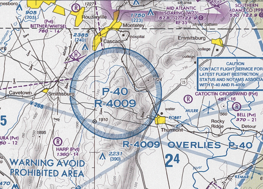
Some prohibited airspace may be supplemented via NOTAMs. For example, Prohibited Area 40 (P-40) and Restricted Area 4009 (R4009) often have additional restricted airspace added via a NOTAM when the president of the United States visits Camp David in Maryland, while normally the airspace outside of P-40 and R4009 is not prohibited/restricted.

Violating prohibited airspace established for national security purposes may result in military interception and/or the possibility of an attack upon the violating aircraft, or if this is avoided then large fines and jail time are often incurred. Aircraft violating or about to violate prohibited airspace are often warned beforehand on 121.5 MHz, the emergency frequency for aircraft.

List of prohibited airspaces

[edit]

Australia

[edit]

China

[edit]

Cuba

[edit]
  • Unscheduled foreign aircraft are prohibited from entering or encroaching Cuban airspace including disputed international water zones except when permission has been explicitly given by the Cuban Government. The Cuban military has been known to shoot down and destroy unauthorised aircraft without warning including a 1996 incident in which two U.S.-registered aircraft were shot down and destroyed by Cuban Air Force MiGs.[3]

Finland

[edit]

France

[edit]
  • All traffic is prohibited above Paris. Exceptions include military aircraft and civil aeroplanes flying no lower than 6,500 feet (2,000 m).[5] Authorisations are either given by the Ministry of Defence, for military aircraft, or by the Paris Police Prefecture and the Directorate General for Civil Aviation for civil ones. Moreover, the flying of helicopters within the limits of Paris (designated the Boulevard Périphérique) is also forbidden. Special authorisation can be granted by the Prefecture of Police for helicopters undertaking precise missions such as police air-surveillance, air ambulances but also transport of high-profile personalities.
  • Although not within Paris boundaries, the business district of La Défense has been placed under prohibited airspace in response to 9/11.[6]

Greece

[edit]

Hungary

[edit]

[7][8]

India

[edit]

Iran

[edit]

Ireland

[edit]

Israel

[edit]

Due to Arab–Israeli conflict, Israeli aircraft are not allowed to fly over numerous countries. These include:

  • Iran
  • Lebanon
  • Syria
  • Iraq
  • Pakistan
  • Libya
  • Tunisia
  • Malaysia
  • Indonesia
  • Yemen
  • Algeria
  • Mali
  • Niger
  • Mauritania
  • Bangladesh

Pakistan

[edit]

Peru

[edit]

Poland

[edit]
  • Temporary flight restrictions over any publicly announced event in a stadium (capacity) or plaza (expected attendance) exceeds 20,000 people by a radius of 5 nautical miles (9.2km) under a height of 5,000 feet (1.5km). An additional strict drone usage restriction is in place for PGE Narodowy Stadium in Warsaw, not permitting usage within 500 metres of the stadium. Non-compliance for both private and corporation actors starts with a minimum fine of 10000PLN (2339 EUR in August 2024)

Russia

[edit]

Many flights are being regularly routed through the outer regions of this airspace due to the Russo-Ukrainian War.

Since October 25, 2015, Ukrainian aircraft have been prohibited from entering Russian airspace.

After the Western countries banned Russian planes from its skies following the Russian invasion of Ukraine, aircraft registered in or operated by Australia, Canada, Japan, New Zealand, Singapore, South Korea, Taiwan, United Kingdom, United States, Norway, Iceland, Switzerland and the European Union member states[12] are banned from using Russian airspace.[13]

On October 30, 2022, Cathay Pacific, a Hong Kong airline, announced that it would resume using Russian airspace on some flights such as the "polar route" from New York to Hong Kong, which had stopped following the Russian invasion of Ukraine.[14]

Due to the Russian invasion of Ukraine, Russian aircraft are not allowed to fly over numerous countries. These include:

  • Andorra
  • Australia
  • Canada
  • European Union member states;
    • Austria
    • Belgium
    • Croatia
    • Czech Republic
    • Denmark
    • Estonia
    • Finland
    • France
    • Germany
    • Greece
    • Hungary
    • Ireland
    • Italy
    • Latvia
    • Lithuania
    • Luxembourg
    • Malta
    • Netherlands
    • Poland
    • Portugal
    • Slovakia
    • Slovenia
    • Spain
    • Sweden
  • Greenland
  • Iceland
  • Japan
  • Liechtenstein
  • New Zealand
  • Norway
  • San Marino
  • Singapore
  • South Korea
  • Switzerland
  • Taiwan
  • United Kingdom
  • United States

Saudi Arabia

[edit]

South Korea

[edit]

Besides, North Korean aircraft must obtain special approval from South Korean authorities before entering its airspace, and must not enter directly above the Military Demarcation Line (MDL).

Sri Lanka

[edit]

According to Air Navigation (Air Defence) Regulation 1 (2007), airspace over the territory and territorial waters of Sri Lanka (except Ruhuna Open Skies Area) are declared an air defence identification zone (ADIZ) with prohibited areas and restricted areas within it. No aircraft may operate in prohibited or restricted areas without valid air defence clearance (ADC) from the Sri Lanka Air Force (SLAF).

Prohibited areas are,[16]

Restricted areas are,[16]

Taiwan

[edit]

Besides, Mainland China-registered aircraft bearing the Chinese national flag are also prohibited from entering Taiwanese airspace.

Turkey

[edit]

Ukraine

[edit]

Since October 25, 2015 all traffic by Russian aircraft has been prohibited. As the result of the Russian invasion of Ukraine, the civilian flights flying over Ukraine and flights to the Ukrainian cities are suspended for the time being.[18]

United Kingdom

[edit]

United States

[edit]

The FAA issues Temporary Flight Restrictions (TFR) in the form of a Notice to Air Missions (NOTAM) which are effective for the duration of an event, typically a few days or weeks. TFRs are issued for VIP movement such as the president's travels outside Washington, D.C., surface-based hazards to flight such as toxic gas spills or volcanic eruptions, air-shows, military security, and special events including political ones like national party conventions.[21] TFRs have also been issued to ensure a safe environment for firefighting operations in the case of wildfires and for other reasons as necessary. A TFR was quickly issued around the crash site of Cory Lidle's airplane in New York City. Later, a broader TFR was issued to require pilots traveling over the East River to obtain air traffic control clearance.

Permanent prohibited areas

[edit]

Temporary restrictions over Disney theme parks were made permanent with language added to a 2003 federal spending bill.[22] Additionally, an indirect TFR prohibits flight below 3,000 feet (910 m) above ground level and within a 3 nautical miles (5.6 km) radius of stadiums with seating capacity of 30,000 or more, in which an World Series, MLS Cup Final, Super Bowl, College Football Playoff National Championship, NASCAR grand slam races, WrestleMania, or the Olympic Games in the United States are taking place, from one hour before to one hour after the event except those sports teams residing and stadiums in Canada.

TFRs over public and corporate venues have been controversial. Groups have questioned whether these last TFRs served a public need, or the needs of politically connected venue operators.[23][24]

Other restrictions

[edit]

In addition to areas off limits to civil aviation, a variety of other airspace restrictions exists in the United States. Notable ones include the Flight Restriction Zone (FRZ) encompassing all airspace up to 18,000 feet (5,500 m) within approximately 15 nautical miles (28 km) of Ronald Reagan Washington National Airport around Washington, D.C. Flights within this airspace, while not entirely prohibited, are highly restricted. All pilots flying within the FRZ are required to undergo a background check and fingerprinting. An additional "Special Flight Rules Area" encompassing most of the Baltimore-Washington D.C. metropolitan area requires the filing of a flight plan and communication with air traffic control.

See also

[edit]

References

[edit]
[edit]
Revisions and contributorsEdit on WikipediaRead on Wikipedia
from Grokipedia
Prohibited airspace designates volumes of airspace above land areas or territorial waters where aircraft flight is entirely banned, typically to protect national security interests such as government facilities or military sites. These areas feature defined dimensions charted by aviation authorities, with no routine authorizations for entry by civil aircraft. In the United States, the Federal Aviation Administration establishes such zones under 14 CFR Part 73, exemplified by P-40 surrounding Camp David in Maryland and P-56 over key Washington, D.C., landmarks including the White House. Flight within prohibited airspace violates federal regulations, subjecting operators to civil penalties up to $1,200,000, certificate suspensions, or immediate interception by defense forces. Distinct from restricted airspace, which may permit transit with agency approval for safety-related activities like training, prohibited zones enforce absolute exclusion to mitigate risks from unauthorized overflights.

Definition and Classification

Core Definition and Characteristics

Prohibited airspace consists of defined volumes over specific terrestrial areas where aircraft operations are categorically banned, with entry permitted only under exceptional authorization from the designated controlling agency. These zones are charted with precise boundaries—lateral extents tied to surface features and vertical limits specified in feet above ground level—and designated by identifiers such as "P-" followed by a numeral in systems like the U.S. Federal Aviation Administration's (FAA) framework. Established primarily for national security, prohibited airspace protects vital installations from aerial threats, encompassing sites like military bases, government headquarters, and nuclear facilities. A key characteristic is the permanence and absoluteness of the restriction, contrasting with temporary or conditional airspaces; prohibitions remain active continuously, irrespective of time or operational status, to preclude any risk of unauthorized overflights. Unlike restricted airspace, which accommodates hazardous activities like artillery firing or missile tests with potential clearances when inactive, prohibited areas foreclose routine approvals, emphasizing protection over accommodation. Violations trigger stringent enforcement, including immediate interception by military assets, regulatory sanctions under codes like 14 CFR §91.133, and potential criminal prosecution, reflecting the airspace's role in safeguarding sovereignty and public welfare. Regulatory designation occurs via rulemaking processes, integrating prohibited airspace into national aeronautical publications and NOTAM systems for pilot awareness, with dimensions published in official registers like the U.S. Federal Register. Internationally, the concept aligns with ICAO Annex 11 provisions on airspace classification, though sovereign states adapt boundaries and enforcement to local imperatives, ensuring no person operates aircraft therein without using agency consent, which is granted sparingly to maintain security integrity.

Distinctions from Restricted and Other Airspaces

Prohibited airspace is characterized by an absolute prohibition on all aircraft operations within its defined dimensions, typically established over land or territorial waters for reasons of national security or to protect vital installations, with no routine permissions granted for entry. In contrast, restricted airspace imposes limitations on flight but does not wholly ban it; aircraft may operate within restricted areas if they comply with specific conditions, such as obtaining prior approval from the controlling agency or avoiding periods of hazardous activity like military exercises or artillery firing. This distinction arises from regulatory frameworks like those of the U.S. Federal Aviation Administration (FAA), where prohibited areas, such as P-56 over the White House, permit entry only via rare, case-by-case authorization from the using agency, whereas restricted areas (e.g., R-2508 for military training) allow air traffic control to route compatible flights through when inactive. Under (ICAO) standards, prohibited areas maintain a permanent ban on overflights, differing from danger areas, which designate where hazardous activities—such as bombing ranges or tests—may occur at specified times, permitting flight outside those periods or with appropriate clearances. Restricted areas align more closely with ICAO's definition of zones restricting flight due to ongoing or intermittent risks but allowing , whereas danger areas emphasize temporary perils without the broader imperatives of prohibited zones. For instance, European AIPs designate danger areas (D) for activities like low-level flying training, where pilots must monitor NOTAMs for activation, unlike the unrelenting no-fly status of prohibited areas (P). Prohibited airspace further diverges from other special use categories, such as military operations areas (MOAs) or alert areas, which do not enforce legal prohibitions. MOAs facilitate military training with segmented airspace but permit non-participating aircraft to transit without permission in joint-use configurations, subject only to separation from hazards. Alert areas, by comparison, serve as advisory zones highlighting concentrations of pilot training or unusual aerial activity, imposing no regulatory barriers to entry. National security areas (NSAs), like those near Washington, D.C., outside core prohibited zones, request voluntary avoidance rather than mandating prohibition, with potential for temporary restrictions via notices to airmen (NOTAMs). These variations underscore prohibited airspace's unique role in enforcing categorical exclusion, rooted in sovereignty and security imperatives rather than operational hazards or advisories.

International Standards under ICAO and Chicago Convention

The Convention on International Civil Aviation, signed on December 7, 1944, establishes the foundational international legal framework for airspace sovereignty and restrictions, including prohibited areas. Article 1 affirms that every contracting state holds "complete and exclusive sovereignty over the airspace above its territory," enabling unilateral designation of prohibited airspace without international approval, subject to non-discriminatory application. Article 9 specifically authorizes each state to "restrict or prohibit uniformly the aircraft of other States from flying over its territory or any part thereof" for reasons of military necessity or public safety, with prohibitions required to apply without distinction of nationality to foreign civil aircraft while permitting special agreements for state aircraft under Article 3. This provision balances national security prerogatives with the convention's aim to promote orderly civil aviation development, mandating that states provide procedures for granting permissions or authorizations for overflights. The International Civil Aviation Organization (ICAO), established by the Chicago Convention, standardizes terminology and operational rules for prohibited airspace across its 193 member states through annexes to the convention. ICAO Annex 15 (Aeronautical Information Services, 16th edition, July 2018) defines a prohibited area as "an airspace of defined dimensions, above the land areas or territorial waters of a State, within which the flight of aircraft is prohibited," emphasizing its establishment by national authority for security purposes. States must publish details of such areas—including coordinates, altitudes, times of activation, and nature of hazards—in their Aeronautical Information Publication (AIP) and via Notices to Air Missions (NOTAMs) to ensure global aeronautical awareness, with ICAO requiring standardized formats for charts and data to facilitate compliance. ICAO Annex 2 (Rules of the Air, 10th edition, November 2005, with amendments) reinforces enforcement by stipulating that "aircraft shall not be flown in a prohibited area... except in accordance with the requirements published by the State in whose territory the area is established," applying to all flights regardless of aircraft type or registration. Annex 11 (Air Traffic Services, 15th edition, 2018) integrates prohibited areas into air traffic management, requiring air traffic services to provide separation or containment from such zones during active operations, particularly where they intersect flight information regions (FIRs) or control areas. These standards promote interoperability while deferring designation and specifics to sovereign states, with ICAO audits (via Universal Safety Oversight Audit Programme) verifying compliance in publication and non-discriminatory enforcement to prevent arbitrary barriers to international air navigation. Non-compliance can lead to ICAO Council recommendations or disputes under Chapter XVIII of the convention, though enforcement relies on state cooperation rather than supranational authority.

National Sovereignty and Variations

The sovereignty of states over their airspace, as codified in Article 1 of the 1944 Chicago Convention on International Civil Aviation, grants each contracting state complete and exclusive authority over the airspace above its territory, forming the foundational legal basis for designating prohibited areas. This principle empowers nations to restrict or prohibit flight operations within defined zones for reasons such as military necessity or public safety, without requiring prior international approval, provided the measures apply uniformly to foreign aircraft under Article 9. Such designations must be limited to reasonable extents and locations to minimize interference with international air navigation, with descriptions published in aeronautical information publications (AIPs) and notified through the International Civil Aviation Organization (ICAO). ![Prohibited Area P-40 over Camp David][float-right] National variations arise from the discretion states exercise within this sovereign framework, leading to differences in the number, size, and specific criteria for prohibited airspaces tailored to domestic security priorities. In the United States, for instance, federal law under 49 U.S. Code § 40103 affirms exclusive sovereignty, enabling the Federal Aviation Administration (FAA) to establish permanent prohibited areas such as P-40, which encompasses approximately 4 nautical miles radius around Camp David for presidential retreats and national security. Other U.S. examples include P-56 over the White House and P-49 over the Naval Observatory, reflecting a focus on protecting executive and military sites with strict no-fly enforcement. In contrast, countries like those in the European Union may integrate prohibited zones into broader flexible use of airspace concepts under ICAO guidance, allowing temporary activations for military exercises while adhering to notification requirements, though permanent zones remain limited to high-sensitivity installations. These variations can include deviations from ICAO standards, which states must file and justify, potentially extending to stricter enforcement or larger zones in geopolitically tense regions. For example, nations facing ongoing security threats may expand prohibited areas beyond ICAO's reasonableness threshold, as seen in historical assertions over international waterways where sovereignty claims intersect with navigation rights, though such extensions risk diplomatic friction if not published adequately. Overall, while the Chicago Convention harmonizes core principles, sovereign discretion results in a patchwork of regulations, with states prioritizing empirical threats like unauthorized overflights near nuclear facilities or command centers over uniform international norms.

Historical Evolution

Origins in Early Aviation and Post-WWII Developments

The concept of prohibited airspace originated during the early years of powered flight, particularly amid World War I, when nations established no-fly zones over military installations, borders, and strategic sites to prevent aerial reconnaissance and attacks. In the United Kingdom, wartime regulations introduced prohibited areas focused on defense, alongside designated entry corridors and compulsory landing grounds, reflecting the nascent recognition of airspace as a controllable domain vulnerable to intrusion. Similarly, neutral countries like the Netherlands banned all overflights of their territory starting August 3, 1914, to safeguard sovereignty amid escalating aerial threats. These measures marked the shift from unregulated balloon-era restrictions—such as Paris's 1784 ban on low-altitude flights over populated areas—to formalized prohibitions tied to national security in the age of military aircraft. In the interwar period, civilian aviation growth prompted more structured regulations, with the United States pioneering permanent prohibited designations around its capital. The first restrictions over Washington, D.C., were enacted via presidential executive order in June 1938, creating P-56 to protect government buildings from unauthorized low-altitude flights, amid rising concerns over espionage and sabotage as commercial air travel expanded. This built on the 1926 Air Commerce Act, which centralized federal oversight of navigable airspace but initially emphasized safety over outright bans. Prohibited areas thus evolved from ad hoc wartime edicts to codified protections under emerging civil aviation frameworks, prioritizing sovereignty over open skies. Post-World War II developments saw wartime restricted zones transition into enduring prohibited airspace, driven by Cold War tensions and the proliferation of sensitive sites. Vast temporary military training areas—totaling hundreds of thousands of square miles—were reviewed after 1945; by the end of 1960, approximately 25,100 square miles of restricted and prohibited airspace had been restored to public use, while 123,700 square miles remained designated, often around atomic facilities, submarine bases, and presidential retreats like Camp David (P-40, formalized in the late 1940s). The 1958 Federal Aviation Act, establishing the FAA, standardized these under Title 14 of the Code of Federal Regulations, emphasizing national defense amid fears of Soviet aerial incursions. Espionage concerns further justified expansions, limiting civil overflights near strategic assets and embedding prohibited zones into the continental control area above 24,000 feet by 1957. This era solidified prohibited airspace as a tool of causal deterrence, balancing aviation commerce against verifiable security imperatives like protecting nuclear infrastructure from potential sabotage.

Expansions Due to Terrorism and Geopolitical Conflicts

The terrorist attacks of September 11, 2001, carried out using hijacked commercial aircraft, directly catalyzed expansions of prohibited and restricted airspace in the United States to prevent similar aerial assaults on high-value targets. In the immediate aftermath, the Federal Aviation Administration imposed a nationwide grounding of civil aviation and designated temporary no-fly zones over Washington, D.C., initially covering a 45-nautical-mile radius to protect the capital from further threats. These measures evolved into codified permanent restrictions, including the enhancement of Prohibited Area P-56, which bans all unauthorized flights over critical sites such as the White House, U.S. Capitol, and Naval Observatory, with amendments in subsequent years to refine boundaries and enforcement protocols amid heightened terrorism risks. The associated Washington, D.C., Air Defense Identification Zone, activated on February 10, 2003, extended identification and control requirements to 60 nautical miles, reflecting a causal shift toward preemptive denial of airspace access based on demonstrated vulnerabilities to non-state actors employing civilian planes as improvised weapons. ![Map of Prohibited Area P-40 over Camp David][float-right] Prohibited Area P-40, overlying the Camp David presidential retreat in Maryland, exemplifies post-9/11 security enhancements, where existing restrictions—originally established in the 1950s for executive protection—were augmented with stricter no-fly enforcement and integrated radar surveillance to counter terrorism-inspired attack vectors, including potential suicide flights targeting isolated leadership sites. Similar expansions occurred around other sensitive U.S. installations, such as nuclear facilities and military commands, with the Department of Defense and FAA collaborating to designate additional sub-areas within broader restricted zones, driven by intelligence assessments of persistent al-Qaeda and affiliated threats. These changes prioritized causal deterrence over prior aviation norms, resulting in over 1,000 annual intercepts of unauthorized aircraft in the national capital region by 2010, underscoring the operational scale of the response. Geopolitical conflicts have similarly prompted expansions of prohibited airspace, often layering permanent bans atop temporary restrictions to address state-sponsored or hybrid threats involving aerial incursions. In Israel, airspace prohibitions over the Dimona nuclear complex were broadened in the 2000s amid escalating tensions with Iran and Hezbollah, incorporating multi-layered no-fly envelopes up to 10,000 feet to safeguard against missile-armed drones or proxy terrorist strikes, as evidenced by repeated violations during cross-border escalations. During the Iraq War (2003–2011), the U.S.-led coalition formalized extensions to existing prohibited zones around Baghdad and oil infrastructure, transitioning some wartime no-fly enforcements into enduring Iraqi designations post-withdrawal to mitigate risks from insurgent groups like ISIS, which later exploited unsecured skies for smuggling and reconnaissance. In the Korean Peninsula, North Korea's prohibited airspace over Pyongyang and missile sites—spanning much of its territory—has seen de facto expansions through unilateral declarations tied to ongoing armistice violations and nuclear saber-rattling, effectively rendering over 80% of its airspace off-limits to foreign operators due to shoot-down precedents like the 1969 EC-121 incident. More recent conflicts, such as the Russia-Ukraine war initiated in 2022, have reinforced trends toward hardened prohibitions, with Ukraine designating permanent no-fly buffers along its borders and over energy grids to counter Russian missile overflights and drone swarms, while Russia imposed reciprocal bans over annexed regions, increasing global rerouting by an estimated 20% in affected corridors and elevating collision risks from compressed traffic. These expansions reflect a realist assessment that geopolitical adversaries amplify terrorism enablers, such as proxy militias, necessitating airspace denial as a first-line defense; however, they have drawn scrutiny for economic externalities, including a 5–10% rise in transcontinental fuel burn from detours. Unlike purely military rationales, terrorism-driven cases emphasize asymmetric threats, where low-tech aircraft exploitation demands blanket prohibitions absent reliable real-time threat discrimination.

Primary Purposes and Justifications

National Security and Military Protection

Prohibited airspace plays a critical role in national security by establishing no-fly zones over military installations and strategic defense sites, thereby preventing unauthorized aircraft from conducting surveillance, reconnaissance, or potential strikes that could compromise operational integrity. These designations deny adversaries the ability to gather intelligence via overflights or position for attacks, a necessity heightened by advancements in aerial threats such as armed drones and hypersonic missiles. In the United States, the Federal Aviation Administration (FAA) establishes such areas under 14 CFR Part 73 when required to protect national welfare, including military assets, with flight prohibitions enforced to mitigate risks from both state and non-state actors. Examples of prohibited airspace directly tied to military protection include zones overlying key command facilities and testing grounds, where even transient violations could expose classified operations. For instance, P-40 in Maryland safeguards the Camp David presidential retreat, a site frequently used for high-level national security deliberations involving military leaders, ensuring aerial isolation during sensitive meetings. Similarly, areas like P-73 in northern Virginia overlap regions proximate to defense infrastructure in the Washington, D.C. vicinity, reinforcing layered defenses against incursions that might target joint military-government coordination hubs. Internationally, prohibited zones around military bases, such as those protecting nuclear facilities with dual civilian-military roles, underscore the causal link between airspace denial and deterrence of sabotage or bombing runs. The justification for these measures stems from empirical evidence of aerial threats in conflicts, where unrestricted airspace has enabled intelligence breaches or attacks, as seen in historical incidents like unauthorized overflights during the Cold War prompting stricter controls. By prohibiting all non-authorized flights, including commercial and general aviation, such airspace upholds causal realism in defense strategy: potential attackers are deterred not by permission requests but by absolute denial, reducing the probability of successful incursions through predictable enforcement via radar detection and interceptor aircraft. This approach prioritizes verifiable security outcomes over permissive models, with data from aviation safety records showing zero tolerated violations in active prohibited zones to maintain deterrence efficacy.

Safeguarding Sensitive Infrastructure and Sites

Prohibited airspace designations protect sensitive infrastructure and sites by barring unauthorized aircraft operations, thereby mitigating risks of aerial surveillance, sabotage, or attack that could compromise national security or public safety. These zones are established over facilities where physical disruption might yield catastrophic outcomes, such as nuclear weapons assembly plants or presidential retreats, reflecting a causal link between uncontrolled low-altitude flights and heightened vulnerability to deliberate threats or inadvertent impacts. In the United States, the Federal Aviation Administration maintains specific prohibited areas for such purposes, including P-40, a 3-nautical-mile radius around Camp David in Thurmont, Maryland, the presidential retreat, where all flights are forbidden at all altitudes to prevent potential intrusions during official use. Similarly, P-49 overlies the Pantex Plant near Amarillo, Texas, the sole U.S. facility for nuclear warhead assembly and disassembly, prohibiting flights to safeguard against espionage or terrorist targeting of high-consequence materials. These measures stem from assessments that aircraft overflights could enable reconnaissance or delivery of hazards, with enforcement justified by the site's hardened defenses requiring aerial denial as an additional layer. Nuclear power plants, while often surrounded by restricted rather than fully prohibited airspace, benefit from security-sensitive restrictions that ban unmanned aircraft systems (UAS) operations from the surface to 400 feet above ground level over designated facilities, addressing drone-enabled threats like those prompting Nuclear Regulatory Commission mandates for sighting reports since 2024. This airspace control counters empirical risks demonstrated by post-2010s drone incursions near energy infrastructure, where unauthorized flights could facilitate radiological sabotage or exacerbate accident scenarios, though plant designs incorporate redundancies against single aerial events. Internationally, analogous prohibitions apply to comparable sites, such as restricted zones over French nuclear facilities under Direction Générale de l'Aviation Civile rules, prioritizing prevention over reaction in high-stakes domains.

Enforcement and Operational Aspects

Detection Technologies and Interception Protocols

Detection of intrusions into prohibited airspace primarily relies on integrated radar surveillance systems that provide continuous monitoring of aerial activity. Ground-based air surveillance radars, such as the Air Route Surveillance Radar (ARSR), operate over large areas to detect non-cooperative aircraft through primary radar returns, scanning 360 degrees to identify potential violations without reliance on transponders. Military-grade systems, including those from Lockheed Martin, enhance this capability with solid-state radars designed for early warning and tactical ballistic missile surveillance, offering high reliability in identifying low-altitude or stealthy threats near sensitive sites. These technologies are complemented by secondary surveillance radar (SSR) for cooperative aircraft equipped with transponders, though prohibited airspace enforcement emphasizes primary detection to counter unauthorized entries. In regions like North America, the North American Aerospace Defense Command (NORAD) integrates these radar feeds with air defense identification zones (ADIZ) to facilitate early detection of aircraft approaching U.S. airspace boundaries, triggering alerts for potential prohibited area incursions. Advanced systems, such as tactical expeditionary radars from Leonardo DRS, classify and track threats ranging from slow-moving aircraft to high-speed intruders, enabling rapid response in dynamic environments. For smaller threats like drones encroaching on prohibited zones, emerging counter-unmanned aircraft systems (C-UAS) incorporate passive detection for real-time awareness, though manned aircraft violations remain the focus of traditional radar networks. Upon confirmed detection of an unauthorized aircraft, interception protocols are activated to identify, warn, and escort the intruder out of the restricted area, following standardized procedures outlined in the FAA's Aeronautical Information Manual and ICAO guidelines. Typically, fighter aircraft are scrambled to approach from astern, minimizing wake turbulence risks, and initiate visual signals to communicate intent. Daytime signals include the interceptor rocking its wings to indicate interception, followed by heading changes to direct the aircraft; an abrupt turn across the intruder's nose signals an immediate need to turn away. Nighttime interceptions employ landing lights: steady flashing lights signal "you are intercepted, follow me," while irregular flashes across the intruder's path mean "turn now." The intercepted pilot must acknowledge by rocking wings or activating landing lights and comply until released, with escalation to forced landing if non-compliance persists, as per military doctrine allowing lawful interception of state or unauthorized aircraft. In practice, NORAD has conducted numerous intercepts for temporary flight restrictions overlapping prohibited areas, such as escorting general aviation aircraft away without incident after visual confirmation. These protocols prioritize de-escalation while ensuring security, with pilots required to monitor NOTAMs and adhere to air traffic control to avoid activation.

Penalties, Violations, and Notable Incidents

Violations of prohibited airspace typically involve unauthorized aircraft penetration, ranging from inadvertent navigational errors to deliberate incursions, and are enforced through national aviation authorities and military protocols. Penalties vary by jurisdiction and intent but commonly include civil fines, criminal prosecution, pilot license suspension or revocation, aircraft impoundment, and, in cases posing imminent threats, interception or use of force by military assets. The International Civil Aviation Organization (ICAO) does not prescribe uniform penalties, deferring enforcement to sovereign states under the Chicago Convention, which affirms territorial airspace control. In the United States, the Federal Aviation Administration (FAA) assesses civil penalties up to $1,200,000 per violation against non-individual entities, with additional sanctions like certificate actions for pilots; willful violations near sensitive sites can escalate to felony charges under federal law. Violations of presidential Temporary Flight Restrictions (TFRs), which often overlap with or supplement prohibited airspace for VIP protection, may result in interception by military aircraft, FAA enforcement including certificate suspension or revocation, and criminal penalties for intentional breaches. The Department of Transportation (DOT) has imposed multimillion-dollar fines on airlines for codeshare operations in FAA-prohibited airspace, including $425,000 against Ethiopian Airlines in December 2024 and $420,000 against Lufthansa and SWISS in the same year, reflecting cumulative enforcement totaling $2.9 million in 2024. For the Washington, D.C. Flight Restricted Zone (encompassing prohibited areas), legislative proposals like H.R. 3465 have aimed to standardize fines at $10,000–$100,000 per incursion. Notable incidents underscore enforcement rigor. In May 2012, U.S. Air Force F-16s intercepted a Piper PA-28 light aircraft that violated temporary prohibited airspace around Air Force One during a Los Angeles visit, forcing compliance via radio warnings and visual escort. A September 2021 event saw an F-16 intercept a U.S. Army Cessna 172 that inadvertently entered restricted airspace over New York City near the United Nations, with air traffic control audio capturing the rapid military response to mitigate perceived threats. Near former President Donald Trump's Mar-a-Lago residence, over 20 civilian aircraft violated temporary flight restrictions (overlapping prohibited zones) in early 2025, prompting multiple NORAD F-16 scrambles; a separate July 2025 cluster involved 11 incursions near his New Jersey golf club, highlighting persistent challenges with private aviation compliance. Inadvertent cases, such as a Cessna 340 pilot penetrating expanded Prohibited Area P-49 near former President George W. Bush's Texas ranch (reported via NASA Aviation Safety Reporting System), often result in post-incident investigations rather than immediate force, though they inform stricter pre-flight advisories. Internationally, the 1996 Cuban shootdown of two Brothers to the Rescue aircraft—claimed as enforcement of a no-fly zone over Havana—demonstrated lethal penalties, killing four civilians and prompting U.S. sanctions, though Cuba asserted the flights violated established prohibitions. Such events reveal causal risks: violations stem from pilot error, inadequate NOTAM dissemination, or geopolitical tensions, with outcomes hinging on perceived threat levels rather than uniform global standards.

Controversies and Debates

Balancing Security Imperatives Against Aviation and Press Freedoms

Prohibited airspace designations prioritize national security by preventing unauthorized aerial incursions that could facilitate attacks, as demonstrated by the establishment of areas like P-56 over Washington, D.C., following heightened threats post-September 11, 2001, and the 1981 assassination attempt on President Reagan. These measures reflect causal links between unrestricted low-altitude access and vulnerabilities exploited in events like 9/11, where commercial aircraft were weaponized, justifying empirical restrictions to mitigate risks to critical sites. However, such prohibitions inherently conflict with aviation freedoms, as general aviation operators, who comprise over 90% of U.S. flights, face severe operational constraints, rendering vast areas unusable for transit or training and imposing economic costs estimated in millions annually from detours and lost opportunities. Critics from aviation organizations argue that the proliferation of temporary flight restrictions (TFRs), often mirroring prohibited airspace rules, exemplifies overreach, with NORAD reporting a "noticeable uptick" in general aviation violations in 2025 due to inadequate NOTAM dissemination, leading to unnecessary intercepts and penalties including certificate suspensions. While security protocols have intercepted violators—such as 11 aircraft diverted over Palm Beach in April 2025 during a TFR for a VIP event—the absence of documented successful GA-based attacks in the U.S. since 9/11 prompts questions about proportionality, as routine restrictions for events like sports gatherings or political rallies disproportionately burden non-commercial pilots without commensurate threat data. Empirical balancing requires weighing prevented incidents, which FAA data attributes to vigilant enforcement, against verifiable impacts like a 2023 Government Accountability Office report noting TFRs' role in delaying emergency medical flights. Press freedoms face analogous tensions, particularly with drone-enabled journalism, where FAA TFRs have barred unmanned aerial systems (UAS) over public events, as in the October 2025 Chicago designation—the "largest drone ban ever"—which the National Press Photographers Association (NPPA) condemned as pretextual suppression, allowing manned aircraft while grounding UAS critical for real-time coverage of protests and infrastructure. Similar restrictions at Standing Rock in 2016 prevented media drone documentation of pipeline conflicts, prompting First Amendment challenges that courts have partially upheld, ruling in a 2025 Sixth Circuit case that state drone bans on public lands for photography violate free speech when not narrowly tailored to security. Media coalitions, including 24 organizations in October 2025, opposed FAA's proposed Part 108 rules, arguing they threaten news gathering—a protected activity under precedents like Branzburg v. Hayes—absent evidence of journalistic UAS posing unique risks beyond manned flights. Security rationales, rooted in preventing surveillance or delivery threats, must empirically justify exclusions, as overbroad bans risk chilling public oversight without proportional gains, per NPPA analyses of FAA's inconsistent application favoring security over enumerated rights.

Criticisms of Overreach and Impacts on Civil Liberties

The establishment of the Flight Restricted Zone (FRZ) around Washington, D.C., following the September 11, 2001, attacks, encompassing a 15-nautical-mile radius and imposing stringent requirements such as transponder mandates and special flight rules, has drawn criticism for disproportionately burdening general aviation operators and infringing on the freedom of aerial movement. Congressional Research Service analyses have noted that such restrictions are highly contentious due to their direct curtailment of air travel liberties and associated costs to pilots, including mandatory training and equipment upgrades that persist over two decades later. Aviation advocacy groups like the Aircraft Owners and Pilots Association (AOPA) have argued that these measures, while justified for immediate security, represent ongoing overreach by limiting routine non-commercial flights without proportional threat assessments. Temporary Flight Restrictions (TFRs), particularly VIP TFRs protecting high-profile figures, have been faulted for their expansive geographic scopes—often spanning thousands of square nautical miles—and unpredictable issuance, which disrupt general aviation without adequate notice or alternatives. AOPA has highlighted instances of "pop-up" TFRs with erroneous coordinates or incomplete NOTAMs, leading to inadvertent violations prosecuted as criminal acts, thereby chilling lawful aviation activities and eroding pilots' operational autonomy. These restrictions frequently close regional airports and force rerouting, imposing economic and logistical hardships that critics contend exceed necessary security protocols, as evidenced by expansions following events like the July 13, 2024, assassination attempt on former President Trump. TFRs imposed over protest sites have faced accusations of overreach by selectively barring civilian and media aircraft while permitting law enforcement surveillance flights, thereby impeding First Amendment protections for journalism and assembly. During the 2016 Standing Rock protests against the Dakota Access Pipeline, a prolonged TFR was criticized by free speech advocates as a de facto prior restraint, preventing independent aerial documentation of clashes and tribal lands while allowing police-contracted aircraft to operate. Legal commentators, including those from Syracuse University, argued this created an uneven playing field that suppressed dissenting coverage without tailored safety justifications. Similarly, a October 2025 TFR over Chicago amid immigration enforcement operations, spanning over 935 square miles, prompted the American Civil Liberties Union to warn of curtailed journalistic documentation and public oversight, raising concerns over opaque extensions that prioritize enforcement opacity over transparency. Such applications underscore broader debates on whether TFRs function as tools for information control rather than pure airspace security.

Recent Developments

Drone Threats and UAS Regulatory Responses (2020s)

The proliferation of commercial and hobbyist unmanned aerial systems (UAS) in the 2020s has amplified threats to prohibited airspace, with unauthorized incursions surging near airports and military bases. In the United States, the Federal Aviation Administration (FAA) documented thousands of drone sightings annually near controlled airspace, including near-misses with commercial airliners that increased as drone usage expanded. By October 2025, over 400 drone sightings were reported over U.S. military installations in the preceding year, marking an 82% year-over-year rise, often involving swarms that evaded initial detection. Notable cases included a 17-day swarm over Langley Air Force Base in early 2024 and repeated incursions prompting concerns over potential foreign espionage, with some analyses linking patterns to Chinese-manufactured drones. In Europe, unidentified drones disrupted operations at NATO-affiliated sites, such as Copenhagen Airport on September 22, 2025, where three drones halted air traffic, alongside sightings over Danish, German, and Belgian military bases, raising alarms about hybrid warfare tactics potentially attributable to state actors like Russia. These incidents underscored vulnerabilities in airspace sovereignty, including risks to critical infrastructure from smuggling, surveillance, or kinetic attacks, as small UAS could penetrate defenses designed for manned threats. U.S. military assessments highlighted that most incursions stemmed from careless operators, but a subset involved sophisticated operations capable of real-time data relay, complicating attribution and response. Regulatory responses intensified to mitigate these risks, emphasizing tracking, mitigation, and enforcement. The FAA implemented mandatory Remote ID requirements in 2023, requiring UAS over 0.55 pounds to broadcast identification and location data, enabling real-time monitoring in prohibited zones. In 2023, the FAA issued guidance for airports on UAS detection and mitigation protocols, including coordination with law enforcement for interception via jamming or netting in restricted areas. The Transportation Security Administration (TSA) proposed expanded security rules in September 2025 for commercial drone operations, mandating vetting of operators and payloads near sensitive sites to prevent threats like those observed in military base incursions. At the federal level, a June 2025 White House executive order established a task force to address UAS threats, directing reviews of operational frameworks and authorizing counter-UAS measures for critical infrastructure, including military bases and mass gatherings. In Europe, the European Union Aviation Safety Agency (EASA) advanced risk-based regulations under its UAS framework, updated in the early 2020s to classify operations by proximity to people and infrastructure, with stricter geo-fencing and no-fly zone enforcement for prohibited airspace. These measures included mandatory registration and operator certification, aimed at curbing incursions like those in 2025 NATO airspace disruptions. Globally, such responses balanced integration of legitimate UAS uses—such as delivery and inspection—with heightened penalties, including fines up to $200,000 per violation under FAA rules, though enforcement challenges persisted due to detection gaps in remote or low-altitude prohibited areas.

Conflict-Driven Restrictions (e.g., Ukraine, Middle East 2022–2025)

Following Russia's full-scale invasion of Ukraine on February 24, 2022, Ukraine's State Aviation Service issued a NOTAM closing its entire airspace to all civil operations effective immediately, citing active military conflict and risks to aviation safety. This prohibition encompassed all flight information regions (FIRs) under Ukrainian control, including contested areas like the Simferopol FIR over Crimea, and has persisted through October 2025 amid sustained hostilities, with no resumption of commercial overflights permitted. Russia reciprocated by restricting Ukrainian-registered aircraft and those from supportive nations, while Belarus limited access due to its role in facilitating the invasion; these measures fragmented regional air corridors, forcing global airlines to reroute flights and increasing operational costs by an estimated 10-20% for affected routes. In response, over 30 countries, primarily in Europe and North America, enacted bans on Russian civil aircraft entering their airspace starting late February 2022, enforced via national aviation authorities and coordinated through bodies like EASA, to pressure Moscow economically and mitigate dual-use risks of Russian carriers. These reciprocal prohibitions extended Russian airspace closures to Western airlines, creating a de facto divided European aviation space; for instance, by March 2022, U.S. carriers like United and Delta suspended all flights over Russia, Belarus, and Ukraine, with diversions adding up to 1,000 nautical miles per transatlantic leg. Ongoing enforcement relies on real-time NOTAMs and ICAO advisories, with violations rare due to stringent pre-flight risk assessments by operators. In the Middle East, airspace restrictions intensified after Hamas's October 7, 2023, attack on Israel, prompting temporary closures of Israeli airspace and adjacent regions in Jordan, Lebanon, and Iraq to civil traffic amid rocket exchanges and airstrikes. Escalations peaked during Israel's June 13, 2025, strikes on Iran, which triggered immediate shutdowns across Iran, Iraq, Syria, Jordan, and Lebanon, halting dozens of airports and diverting over 500 daily flights regionally; countries like Saudi Arabia and the UAE issued partial restrictions on overflights near conflict zones to avoid missile trajectories. A ceasefire on June 24, 2025, led to most reopenings by late June, though EASA and FAA maintained heightened warnings for GPS spoofing and short-notice closures in Iranian and Lebanese airspace as of October 2025. These conflict-driven prohibitions in the Middle East have been characterized by rapid, reversible NOTAMs tied to kinetic events, contrasting Ukraine's prolonged blanket ban; for example, during the 12-day Israel-Iran exchanges in June 2025, airlines like Emirates and Qatar Airways suspended services to affected hubs, rerouting via southern corridors over the Arabian Sea and incurring fuel surcharges averaging $50,000 per long-haul flight. Regional authorities justified restrictions on empirical risks from air defense interceptions and debris, with data from flight tracking services showing a 30-50% drop in overflights during peaks, though critics note inconsistent application favoring military priorities over commercial needs. Iran has issued multiple NOTAMs across various regions, resulting in widespread temporary airspace restrictions; some newly issued for military drills, such as NOTAM A2412/25 closing western areas in August 2025, while others remain active from prior security concerns. By mid-2025, partial normalizations occurred, but persistent Iran-Israel tensions sustain elevated no-fly advisories for civilian operators.

Global Examples

North America

In the United States, prohibited airspace consists of defined volumes where flight is strictly forbidden at all times without explicit authorization from the using agency, primarily for and to protect sensitive installations. The (FAA) designates these areas under 14 CFR Part 73, with details published in FAA Order JO 7400.11. There are approximately seven permanent prohibited areas in the , each identified by a "P-" followed by a number, depicted on sectional aeronautical charts. Key examples include P-40, located over the Camp David presidential retreat in Thurmont, Maryland, extending from the surface to but not including flight level 180 (approximately 18,000 feet MSL), excluding overlapping restricted areas R-4001A and R-4001B when active. P-47 overlies the Pantex Plant nuclear weapons assembly facility near Amarillo, Texas, in the Texas Panhandle. P-49 covers sensitive areas in central Texas, originally associated with presidential properties. P-56 secures the airspace over Washington, D.C., including the White House and National Mall, from the surface to 15,000 feet MSL, subdivided into P-56A and P-56B. P-67 protects coastal regions in Maine, while P-73 encompasses the Groom Lake facility (commonly known as Area 51) in Nevada for classified military operations, from the surface to flight level 180. Additional areas like P-204 and P-205 apply low-altitude restrictions over wilderness regions in Minnesota, such as near Ely and Tower, to preserve environmental sensitivity. Canada employs restricted airspace designations under Class F (CYR for restricted) managed by NAV CANADA and Transport Canada, rather than outright prohibited zones, for security-sensitive locations including government buildings in Ottawa and temporary wildfire perimeters. Entry requires prior permission from the controlling or user agency, with no permanent equivalent to U.S. prohibited areas. In Mexico, airspace restrictions are predominantly temporary or military training areas (e.g., irregular shapes up to FL600), enforced by the Mexican Air Navigation Services (SENEAM), without standardized permanent prohibited designations akin to those in the U.S. These measures prioritize operational security while allowing case-by-case authorizations.

Europe

In Europe, prohibited airspace is established by individual member states under harmonized standards set by the European Union Aviation Safety Agency (EASA), as outlined in Regulation (EU) 2017/373, which defines prohibited areas as airspace volumes where aircraft flight is entirely banned, typically to safeguard national security, military operations, or critical infrastructure. These designations appear in each country's Aeronautical Information Publication (AIP) and are enforced to prevent unauthorized overflights, with violations subject to interception or penalties by air defense authorities. Restricted areas, by contrast, permit flight under specific conditions such as prior authorization or altitude limits, often overlapping with prohibited zones for layered protection. European airspace features a high density of such restrictions due to the continent's concentration of military bases, nuclear facilities, and urban centers, complicating general aviation and requiring pilots to consult real-time NOTAMs via Eurocontrol. The United Kingdom designates permanent prohibited areas primarily over nuclear and defense sites, as detailed in NATS airspace charts. Prohibited Area P611 covers the Coulport/Faslane complex in Scotland, encompassing the Royal Naval Armaments Depot and Trident nuclear submarine berths, where all aircraft entry is forbidden to mitigate risks from potential sabotage or radiological hazards. Similarly, P813 prohibits flights over the Dounreay nuclear research site in northern Scotland, a legacy facility with decommissioning activities that heightens security concerns. The UK Civil Aviation Authority oversees exemptions for rare authorized entries, such as military or emergency operations, but routine civilian overflights remain strictly barred. France maintains prohibited zones around its 19 operational nuclear power plants, enforced by a blanket regulation banning flights below 1,000 meters (3,280 feet) within a 5-kilometer (3.1-mile) radius of each site to counter aerial threats, including unauthorized drone incursions documented in 2014 over facilities like those operated by EDF. These restrictions extend to military installations and were reinforced post-incidents involving unidentified UAVs breaching no-fly perimeters, prompting heightened surveillance by the French air defense network. Additional temporary prohibited areas activate during high-security events, such as around Paris for state visits or major gatherings, integrating with broader restricted zones over industrial and urban sensitive areas. Other European nations apply similar protections tailored to national priorities. In Germany, prohibited and restricted areas encircle military training grounds and environmental preserves, such as those near wildlife habitats, to prevent disturbances while allowing conditional access for approved flights. Finland's permanent restricted areas, managed by the Defence Forces, overlay military zones with prohibitions unless special permissions are granted, reflecting the country's emphasis on territorial defense. Portugal exemplifies the prevalence of military-focused restrictions, with areas like LPR39A over Tancos army base and LPR70A over Monte Real air base barring unauthorized entry to protect operational assets. These patchwork designations underscore Europe's fragmented yet interconnected airspace management, where national sovereignty prevails under EASA oversight, often resulting in a "full" chart of active zones that demands vigilant pilot compliance.

Middle East and Asia

In the , prohibited airspace frequently arises from religious imperatives and geopolitical tensions. enforces a comprehensive over , encompassing the in , and , including Masjid al-Nabawi, to uphold the sanctity of these holiest Islamic sites; all non-essential aircraft overflights are banned, with violations punishable under Saudi regulations, primarily to avoid disrupting pilgrims and maintain spiritual reverence rather than due to any geophysical anomalies. This restriction extends radially outward, rerouting international flights via designated corridors during peak periods, which accommodate millions of arrivals annually at nearby . Security-driven prohibitions dominate in conflict-prone areas. The United States Federal Aviation Administration (FAA) maintains a ban on U.S. operators entering the Tehran Flight Information Region (FIR) in Iran, extended through October 2025, citing risks from military activities, missile tests, and potential misidentification of civilian aircraft amid U.S.-Iran hostilities. Similarly, restrictions apply to the Baghdad FIR in Iraq below 20,000 feet, renewed through 2024, due to ongoing threats from armed groups and anti-aircraft fire, limiting commercial operations to higher altitudes or approved routes. Historical precedents include U.S.-led no-fly zones over northern Iraq (Operation Provide Comfort, initiated April 1991) and southern Iraq (Operation Southern Watch, August 1992), enforced until 2003 to shield Kurdish populations from chemical attacks and Shiite communities from reprisals by Saddam Hussein's forces, involving coalition patrols that intercepted over 1,000 Iraqi aircraft. In Asia, prohibited airspace underscores regime isolation and military priorities. North Korea's entire territory constitutes a prohibited area for U.S. flights, as per FAA Notice to Air Missions (NOTAM) KICZ, due to the Democratic People's Republic's nuclear program, frequent missile launches—over 100 in 2022 alone—and explicit threats against reconnaissance aircraft, rendering overflights untenable without risking shoot-downs. Chinese authorities designate multiple prohibited zones (P-zones) under the Civil Aviation Administration, including a 40-nautical-mile radius around Beijing and restricted military areas in the East and South China Seas, enforced via air defense identification zones (ADIZ) that require prior notification for foreign aircraft, aimed at protecting state infrastructure amid territorial disputes. India's prohibited areas include P-53 over the Kashmir Valley and sensitive sites near New Delhi, activated during border skirmishes with Pakistan, such as post-2019 Pulwama attack closures that diverted flights and heightened surveillance to counter potential incursions. These measures reflect causal links between territorial claims and aviation controls, often escalating during crises like the 2020 India-China Ladakh standoff, which prompted temporary airspace suspensions.

Other Regions

In Africa, prohibited airspace designations frequently arise from armed conflicts, terrorism risks, and political instability rather than permanent security perimeters around fixed sites. Libyan airspace has been subject to operational prohibitions since the civil war escalated in 2014, with international aviation authorities advising against all flights due to active hostilities and militia control over key facilities. Similarly, Sudan maintains no-fly restrictions amid its ongoing civil war, which intensified in 2023, prohibiting unauthorized overflights to mitigate risks from ground fire and unsecured airports. In Somalia, the U.S. Federal Aviation Administration extended a ban on certain flights below Flight Level 260 (approximately 26,000 feet) through at least 2023, citing threats from al-Shabaab militants and inadequate air traffic control, a measure echoed by other regulators for non-essential operations. Diplomatic disputes have also prompted temporary prohibitions, as seen in April 2025 when Algeria and Mali imposed reciprocal bans on each other's airspace following accusations of sovereignty violations, disrupting regional routes until resolved through mediation. South African airspace, by contrast, features no nationwide prohibitions but includes designated danger areas for military training and live-fire exercises, activated via notices to airmen (NOTAMs) under the Aeronautical Information Publication, with dimensions varying by site—such as areas up to 10,000 feet altitude and 20 nautical miles radius. In Oceania, Australia designates no permanent prohibited airspace, a policy shift from prior restrictions around the Pine Gap intelligence facility near Alice Springs, which was de-prohibited in the early 2000s; instead, temporary restricted zones are enforced around military bases, bushfire operations, or events like airshows, often extending to 5,000 feet above ground level and requiring prior authorization. Other Pacific island nations, lacking sovereign airspace prohibitions, rely on flight information regions (FIRs) managed by Australia or Fiji, with ad hoc restrictions for volcanic activity or U.S. military exercises in areas like the Coral Sea. Antarctica operates under the 1959 Antarctic Treaty, which imposes no formal prohibited airspace but mandates environmental protocols and permits for flights, effectively limiting commercial overflights due to extreme weather, lack of navigation aids, and requirements for specialized cold-weather equipment on aircraft; research and logistical flights by treaty signatories, such as those to McMurdo Station, occur routinely below 71° south latitude with survival gear mandates, but no outright bans exist.

References

Add your contribution
Related Hubs
User Avatar
No comments yet.