
Community hub
Recent from talks
Contribute something
Nothing was collected or created yet.
Rayners Lane
View on Wikipedia
Rayners Lane is a suburban district in the London Borough of Harrow that forms the western part of Harrow in northwest London. Located between Pinner and West Harrow,[2] it takes its name from a road in the area, also called Rayners Lane (formerly also spelt Rayner's Lane) which runs from Marsh Road in Pinner to Eastcote Lane in South Harrow.
Key Information


History
[edit]The first documented use of Rayner as a place name in Pinner was from 1856 when two fields, Upper Rayners Field and Lower Rayners Field, were mentioned in a conveyance. These were named after the Rayner family, who moved from Ruislip to Pinner at the start of the 19th century.[3] It is assumed the Rayners Lane roadway was given that name sometime before the Rayner family left the area in the 1870s.[3] The roadway was often called Bourne Lane, because it crossed several streams, including the Yeading Brook.[3] During the medieval period, it functioned as a nameless service road linking Pinner and Roxeth.[4] It was used to transport grain to the mill on Pinner Green.[citation needed]
The Metropolitan Railway was extended to Uxbridge from Harrow on the Hill in 1904, passing across Rayners Lane.[citation needed] A halt was built at Rayners Lane, opening in 1906. Despite this, the area remained rural, with a single farmstead north of the halt.[5]
The area saw wide-ranging development in the 1930s. The developments were part of the Metropolitan Railway's plans to bring customers to its railway by developing the surrounding countryside – an area marketed as Metro-land.[6]
The first development in Rayners Lane was in 1927 when Metropolitan Railway Country Estates Ltd. purchased land north of the station. The development, named Harrow Garden Village, was built by E.S. Reid and was laid out on garden suburb principles.[7]
Further developments followed after Tithe Farm south of the Piccadilly Line was sold to T.F. Nash Ltd. in about 1930. This was the widest-scale development in the Pinner area and consisted of cheap, mostly terraced housing.[8] Nash excelled at advertising the estate,[5] and in 1933 he constructed a temporary 35-foot illuminated wooden arch across Alexandra Avenue as part of an advertising promotion.[8]
.jpg)
Other developers were also active in the area. H.J. Mark was a prolific architect who designed many buildings on the Alexandra Avenue shopping parade.[5] Charles Holden and Reginald Uren redesigned the station which was completed in 1938[9] and served the Metropolitan and Piccadilly tube lines.
In October 2002, Rayners Lane Conservation Area was designated by Harrow Council. This covers the area around the station and the shopping parades on Alexandra Avenue. The designation aims to protect the character of the area and identify opportunities to preserve and improve it.[5]
Governance
[edit]
Rayners Lane lies within the London Borough of Harrow, governed under the local authority of Harrow London Borough Council. The Rayners Lane ward was established in The London Borough of Harrow (Electoral Arrangements) Order 1978,[10] comprising areas that were previously part of the Pinner South and Roxbourne wards.[11] The first elections in the ward were held in May 1978 in which three Conservative councillors were elected.[10][12]
Ward boundaries were revised in 2000[13] and most recently in 2020, taking effect in the 2022 council elections.[14] As a result of the 2020 changes, the Rayners Lane ward lost the Harrow Garden Village area north of the station to the Pinner South ward. It also had its total number of councillors reduced from three to two.[14] In 2022, Krishna Suresh (Labour) and Thaya Idaikkadar (Conservative) were elected as councillors to represent the ward[15] while the Conservative Party took control of the council.[16]
Rayners Lane is in the Brent and Harrow constituency for the London Assembly which has been represented since 2021 by Krupesh Hirani (Labour).[17] It is also in the Harrow West parliamentary constituency[18] which has been represented since 1997 by Gareth Thomas (Labour).[19] The Pinner South ward is part of the Ruislip, Northwood and Pinner parliamentary constituency[18] represented since 2019 by David Simmonds (Conservative).[20]
| Party | Candidate | Votes | % | ±% | |
|---|---|---|---|---|---|
| Labour | Krishna Suresh | 1,399 | 44.1 | +1.2 | |
| Conservative | Thaya Idaikkadar | 977 | 30.8 | +1.9 | |
| Labour | Tarza Ahmed Sharif | 962 | 30.3 | −8.6 | |
| Conservative | Mala Morjaria | 886 | 27.9 | +0.0 | |
| Liberal Democrats | Chris Noyce | 665 | 20.9 | −15.9 | |
| Independent | Sockalingam Yogalingam | 559 | 17.6 | N/A | |
| Liberal Democrats | Gerri Noyce | 426 | 13.4 | −14.7 | |
| Green | Rowan Nicholas Charles Langley | 182 | 5.7 | N/A | |
| Independent | Herbie Crossman | 166 | 5.2 | N/A | |
| Turnout | 3,175 | 45.0 | |||
Geography
[edit]Rayners Lane is located in the upper part of the Crane Valley within the catchment area of the River Crane.[21] The east and west branches of Yeading Brook, the dominant source of the Crane, pass through the surrounding area.[22]
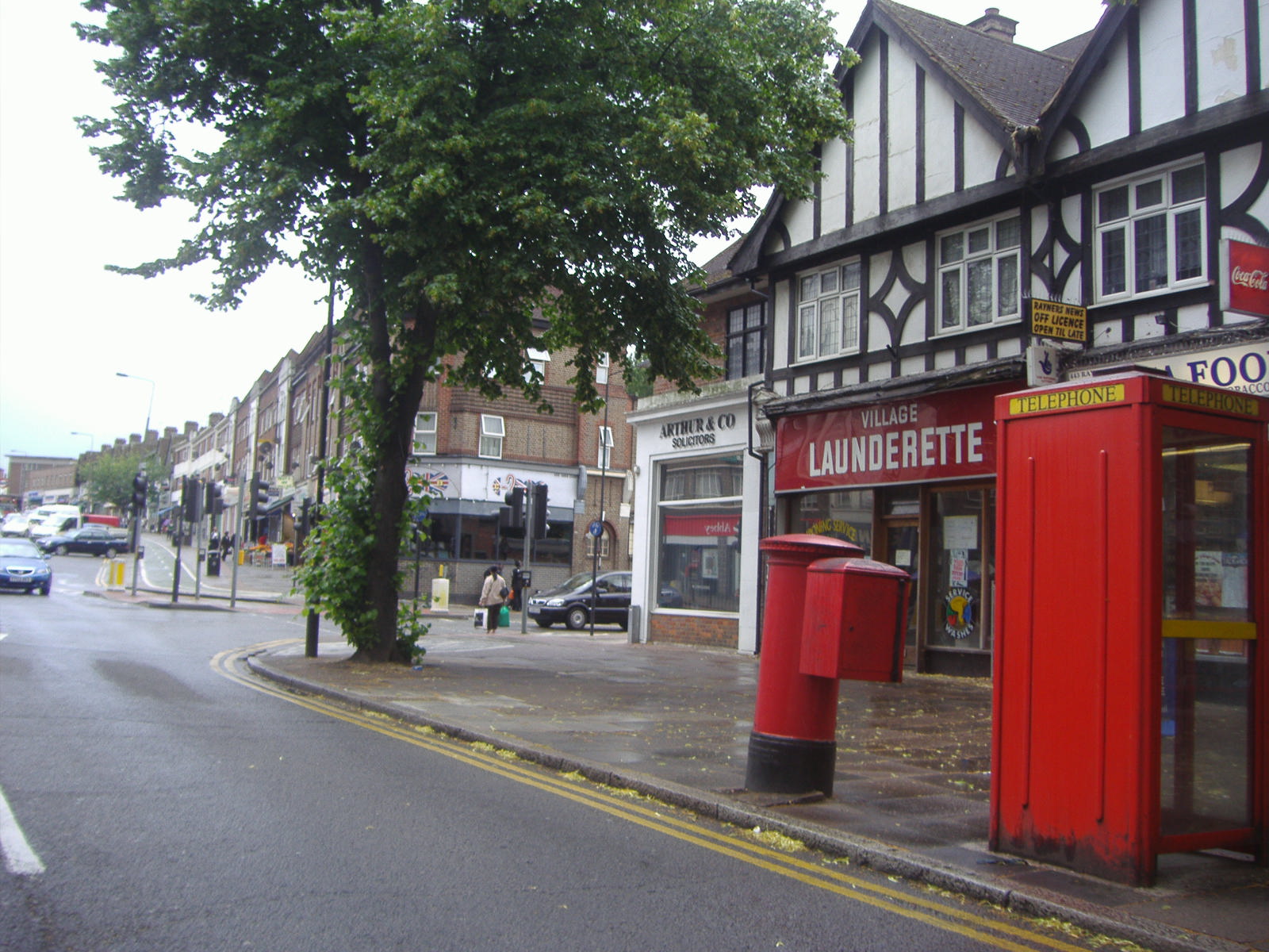
Built atop a railway bridge, the Underground station marks the highest point in the area. It is a focal point of the Rayners Lane conservation area, which includes the shopping parades north and south of the station. Beyond this area, terraced and semi-detached houses built in the 1930s form much of the district.[5] In the 2021 census, 49.04% of households were reported to be terraced, the highest proportion of any ward in the London Borough of Harrow.[23] The remainder were 32.29% semi-detached, 11.25% flats and 3.51% detached.[1] Despite being a relatively small area, it boasts many retail chains.
Neighbouring areas of Rayners Lane | ||||||||||||||||
|---|---|---|---|---|---|---|---|---|---|---|---|---|---|---|---|---|
| ||||||||||||||||
Demography
[edit]The largest ethnic group in Rayners Lane ward in the 2011 census was Indian (28%), followed by White British (27%) and other Asian (21%).[24] It has one of London's largest Tamil communities.[25]
According to the 2021 census, 56.1% of the population identified as Asian, Asian British or Asian Welsh (including 30.43% as Indian and 20.65% as other Asian), followed by White (25.5%) and Other ethnic group (10.32%).[1] The ward ranked 22nd in the London Borough of Harrow for people identifying as White and first for those identifying as Other ethnic group.[23]
In the 2021 census, 39.9% of respondents identified as Hindu–the highest of all wards in the London Borough of Harrow[23]–followed by 28.1% as Christian and 13% as Muslim.[1] No Religion was answered by 8.8% of respondents. The ward also ranked first in Harrow among those identifying as Sikh at 2.44%.[23] In the 2011 census, it was reported that 34 adherents of Zoroastrianism lived in the Rayners Lane ward.[25]
Of Rayners Lane's residents aged 16 or over, 62.56% were reported as economically active. The main occupations were 'Professional occupations' and ‘Managers, directors and senior officials’.[23]
| Ethnic group | 2011 Census[24] | 2021 Census[1][Note 1] | ||
|---|---|---|---|---|
| Population | % | Population | % | |
| Asian, Asian British or Asian Welsh[Note 2] | 6,064 | 54.5 | 5,135 | 56.1 |
| Black, Black British, Black Welsh, Caribbean or African[Note 3] | 588 | 5.3 | 447 | 4.9 |
| Mixed or Multiple ethnic groups | 361 | 3.2 | 292 | 3.2 |
| White | 3,840 | 34.5 | 2,330 | 25.5 |
| Other ethnic group | 271 | 2.4 | 944 | 10.3 |
| Total | 11,124 | 100.0 | 9,148 | 100.0 |
Landmarks
[edit]The principal point of architectural interest is the Grade II* listed former Ace Cinema, an Art Deco building designed by F.E. Bromige that opened in 1936.[26] Notably, it features a stylised elephant's trunk on the entrance canopy.[5] The building was acquired in 2000 by the Zoroastrian Trust Funds of Europe and is now known as the Zoroastrian Centre.[27] It is the only temple of its type in the UK.[citation needed]
Charles Holden and Reginald Uren designed the station building at Rayners Lane tube station which opened in 1938. It was Grade II listed in 1994, noted for the mature design of its frontage and the variety of the surviving signage and fixtures.[9]
The Rayners Public House was Grade II listed in 2006 by Historic England. It is a notable example of 1930s public house architecture retaining much of its original joinery and fittings.[28] It closed as a public house in 2006 and is now occupied by the Christ the Redeemer religious training college.[29]
The shops at 464-472 Alexandra Avenue are locally listed by Harrow Council.[30] They were built in the International style by R.C. White-Cooper and S.R. Turner in 1937.[5]
-
 Zoroastrian Centre
 -
 Rayners Lane Station
 -
 Rayners Public House
 -
 464-472 Alexandra Avenue (left)


Education and Community
[edit]Education
[edit]Roxbourne Primary School is the only school in the Rayners Lane ward. Outside the ward, nearby schools include Longfield Primary School; Newton Farm Nursery, Infant and Junior School; and Buckingham Preparatory School. A library used to be located on Imperial Drive, but was closed in 2015 as part of budget cuts by Harrow Council despite objections raised during a public consultation.[31][32]
Religion
[edit]In addition to the Zoroastrian Centre, Rayners Lane Baptist Church and a Quaker Meeting House reside nearby. The Baptist church was founded in 1934 and dedicated to Janet Hoare, a missionary who died in India while still young.[33] Her father became the first minister of the church. The Quaker Meeting House was the first in Harrow, erected in 1935.[33]
Sport and Leisure
[edit]Rayners Lane F.C. and Broadfields United F.C. play at the Tithe Farm Sports & Social Club.[34] As of the 2024/25 season, Rayners Lane play in the Isthmian League South Central Division.[35] In 2021, Broadfields United entered a groundshare agreement with Rayners Lane having previously groundshared with Harefield United.[36] They play in the Combined Counties League Premier Division North as of the 2024/25 season.[37]

Rayners Lane also has a sports club called Harrow Town Sports Club which has been in existence since the 1890s.[citation needed] It is the home of the Harrow Town Cricket Club who have played in the Middlesex County Cricket League since 2002.[38] Venceremos FC and the HT Tennis Club are also based at the sports club.[citation needed]
There are several open spaces in or near Rayners Lane including Rayners Mead, Newton Park and Roxbourne Park.[39] Yeading Brook runs through Roxbourne Park which has a miniature railway open to the public on Sundays and provides access to the Roxbourne Nature Reserve.[40]
Newton Farm Ecology Park is a small area of meadows and woodland located between Alexandra Avenue and Rayners Lane that was converted into a nature reserve in 1990. It is situated on what was once a floodplain where the east branch of Yeading Brook and the Roxbourne River converge.[41]
Transport
[edit]London Underground
[edit]The Metropolitan and Piccadilly lines converge at Rayners Lane Station. Both lines run services westbound along the same track towards Uxbridge. Eastbound Metropolitan line services run into central London via Harrow-on-the-Hill while eastbound Piccadilly line services run via South Harrow and Acton Town. Some westbound Piccadilly line trains terminate at the station by making use of a reversing siding.
Bus routes
[edit]Four bus routes serve the area. The H12 runs between South Harrow and Stanmore; the H9 and H10 run anticlockwise and clockwise routes of Harrow respectively and the 398 runs between Wood End in Northolt and Ruislip tube station.
In popular culture
[edit]"Rural Rayners Lane" is mentioned in John Betjeman's poem The Metropolitan Railway (Baker Street Station Buffet). It was published in his 1954 anthology A Few Late Chrysanthemums and his Collected Poems in 1958.[42]
Notable people
[edit]Former Cunard officer Commodore Harry Grattidge, one of the last captains of the RMS Queen Elizabeth, lived at number 33 High Worple, Rayners Lane until his death in the 1970s.[citation needed]
Dev Patel
[edit]Dev Patel is a BAFTA award-winning internationally renowned British actor who grew up in Rayners Lane.[43]
Jai Paul
[edit]Jai Paul is an electronic music recording artist signed to XL Recordings, whose influential songs of the 2010s have been sampled by Drake and Beyoncé. He and his brother A. K. Paul grew up in Rayners Lane.[44]
Notes
[edit]References
[edit]- References
- ^ a b c d e f "2021 Census Area Profile - Rayners Lane Ward (as of 2022), Harrow Local Authority". www.nomisweb.co.uk. Retrieved 15 October 2024.
- ^ "Rayners Lane". hidden-london.co.uk. Retrieved 18 July 2007.
- ^ a b c Clarke 2004, p.124—125
- ^ Clarke 2004, p.15—16
- ^ a b c d e f g "Pinner Conservation Areas". www.harrow.gov.uk. Retrieved 12 October 2024.
- ^ Clarke 2004, p.175—176
- ^ Clarke 2004, p.182
- ^ a b Clarke 2004, p.183
- ^ a b "Rayners Lane Station Historic England". historicengland.org.uk. Retrieved 12 October 2024.
- ^ a b "Harrow Council Overview" (PDF). www.harrow-elections.co.uk. Retrieved 14 October 2024.
- ^ "1978 Ward Boundary Changes" (PDF). www.harrow-elections.co.uk. Retrieved 14 October 2024.
- ^ "Harrow Election Results (1964-2010)" (PDF). www.electionscentre.co.uk. Retrieved 14 October 2024.
- ^ "2002 Ward Boundary Changes" (PDF). www.harrow-elections.co.uk. Retrieved 14 October 2024.
- ^ a b "2022 Ward Boundary Changes" (PDF). www.lgbce.org.uk. Retrieved 14 October 2024.
- ^ "2022 Rayners Lane Ward Election Results". harrow.gov.uk. Retrieved 14 October 2024.
- ^ "2022 Harrow Council Election Results". harrowtimes.co.uk. Retrieved 14 October 2024.
- ^ "Brent and Harrow constituency". www.london.gov.uk. Retrieved 14 October 2024.
- ^ a b "Parliamentary Constituencies". www.legislation.gov.uk. Retrieved 14 October 2024.
- ^ "Gareth Thomas (MP)". members.parliament.uk. Retrieved 14 October 2024.
- ^ "David Simmonds (MP)". members.parliament.uk. Retrieved 14 October 2024.
- ^ "Crane Valley". www.cranevalley.org.uk. Retrieved 11 October 2024.
- ^ "Harrow CF Watercourses". www.harrowncf.org. Retrieved 11 October 2024.
- ^ a b c d e "2021 Census Insights". areainsights.co.uk. Retrieved 15 October 2024.
- ^ a b "2021 Census Dataset - Rayners Lane Ward, Harrow Local Authority".
- ^ a b "Demographics - Hidden London". hidden-london.com. Retrieved 23 April 2018.
- ^ "Ace Cinema Historic England". historicengland.org.uk. Retrieved 12 October 2024.
- ^ "Zoroastrian Centre Openhouse". openhouse.org.uk. Retrieved 12 October 2024.
- ^ "The Rayners Public House Historic England". historicengland.org.uk. Retrieved 12 October 2024.
- ^ "Christ the Redeemer College". www.theguardian.com. Retrieved 12 October 2024.
- ^ "Harrow Council Listed Buildings". www.harrow.gov.uk. Retrieved 12 October 2024.
- ^ "Rayners Lane Library Closure". www.harrowtimes.co.uk. Retrieved 15 October 2024.
- ^ "Rayners Lane Library Location". www.mylondon.news. Retrieved 15 October 2024.
- ^ a b Clarke 2004, p.188
- ^ Football Club Details:
- "Rayners Lane F.C." www.footballwebpages.co.uk. Retrieved 10 October 2024.
- "Broadfields United F.C." www.footballwebpages.co.uk. Retrieved 10 October 2024.
- ^ "Isthmian League South Central Division". www.footballwebpages.co.uk. Retrieved 10 October 2024.
- ^ "Broadfields United F.C." www.broadfieldsunitedfc.co.uk. Retrieved 10 October 2024.
- ^ "Combined Counties League Premier Division North". fulltime-league.thefa.com. Retrieved 10 October 2024.
- ^ "Middlesex County Cricket League". www.middlesexccl.com. Retrieved 10 October 2024.
- ^ Rayners Lane Parks:
- "Rayners Mead". www.harrow.gov.uk. Retrieved 11 October 2024.
- "Newton Park". www.harrow.gov.uk. Retrieved 11 October 2024.
- "Roxbourne Park". www.harrow.gov.uk. Retrieved 11 October 2024.
- ^ "Roxbourne Park". www.harrow.gov.uk. Retrieved 11 October 2024.
- ^ "Harrow CF Newton Farm" (PDF). www.harrowncf.org. Retrieved 11 October 2024.
- ^ Betjeman 1958, Collected Poems
- ^ "Dev Patel: 'I'm just this guy from Rayners Lane – how the hell did this happen?'". The Guardian. 15 January 2017. Retrieved 27 October 2020.
- ^ "Jai Paul". jai-paul.com. Archived from the original on 10 June 2023. Retrieved 18 August 2023.
- Bibliography
- Clarke, Patricia. A. (2004) A History of Pinner. Chichester, West Sussex: Phillimore ISBN 978-1860772870
- Betjeman, John (1958) Collected Poems. London: John Murray, ISBN 978-1444725292
Sources
[edit]| Districts |
|   | ||
|---|---|---|---|---|
| Attractions | ||||
| Parks and open spaces | ||||
| Constituencies | ||||
| Tube and rail stations | ||||
| Other topics | ||||
| Authority control databases: Geographic |
|---|
Rayners Lane
View on GrokipediaHistorical Development
Origins and Early Settlement
The lane forming the basis of modern Rayners Lane served as a medieval service road connecting the hamlets of Pinner and Roxeth within the ancient parish of Harrow-on-the-Hill, primarily used for transporting grain to mills on Pinner Green.[6] [11] Originally designated Bourne Lane after a nearby stream, it traversed open agricultural fields with minimal settlement, reflecting the rural character of Middlesex's farmland under feudal manorial systems centered on Harrow.[6] [12] By the 19th century, the lane had been renamed Rayners Lane after the Rayner family, tenant farmers who occupied a local farmstead for approximately half a century and gave their name to the surrounding roadway and adjacent holdings.[11] [12] The area remained dominated by scattered farms and arable land, with ownership patterns tied to larger estates; for instance, mid-century fields along the lane were held by Daniel Hill, whose family controlled significant portions until the early 20th century.[13] [14] This era saw no substantial infrastructure beyond the unpaved lane itself, which functioned as a basic conduit for agricultural traffic amid predominantly unenclosed common fields and hedgerow-bound plots.[15] Encroachment from London's expanding periphery was limited before 1900, as the locale's isolation—surrounded by eight square miles of undeveloped farmland—preserved its agrarian use, with only isolated farm buildings like Rayners Lane Farm marking human presence.[13] [12] Local landowners maintained traditional plotting for crop rotation and livestock, resisting early speculative subdivision despite nascent railway corridors nearby that foreshadowed future connectivity without yet spurring settlement.[6]Interwar Suburban Expansion
The opening of Rayners Lane tube station in 1906 on the Metropolitan Railway initially served a rural area, but the extension of the Piccadilly line services to the station in 1933, followed by a new station building designed by Reginald Uren in 1938, catalyzed suburban development by improving access to central London.[12][16] This infrastructure upgrade was part of the Metropolitan Railway's broader strategy to promote "Metroland" suburbs, attracting commuters fleeing inner London's overcrowding and high densities post-World War I.[17] Harrow Garden Village emerged as a flagship project in the early 1930s, featuring semi-detached and terraced homes with large bay windows and gardens, drawing on garden city principles of low-density living with green spaces to appeal to middle-class families seeking affordable alternatives to urban tenements.[18] Developer T.F. Nash Ltd. acquired Tithe Farm south of the station around 1930, constructing approximately 4,000 houses extending toward Eastcote Manor by the mid-1930s, which transformed former agricultural fields into a planned residential suburb.[4] These speculative ventures capitalized on cheap land and rail proximity but carried risks of market saturation, as evidenced by the rapid pace of interwar building that occasionally outpaced demand in outer London estates.[19] Migration patterns reflected causal pressures from London's inner boroughs, where post-1918 housing shortages and population densities exceeding 100 persons per acre drove outward movement; Rayners Lane's developments absorbed this influx, with Harrow's urban district seeing its population rise from around 70,000 in 1921 to over 200,000 by 1939, fueled by such suburban housing booms.[13] Building activity surged, with permits enabling the erection of thousands of units tailored for clerical and skilled workers commuting to the City, underscoring transport's role in enabling affordable homeownership amid speculative financing.[20]Post-War and Modern Evolution
In the immediate post-World War II era, Rayners Lane saw the construction of council estates to address severe housing shortages exacerbated by wartime bombing and returning servicemen, with the Rayners Lane Estate developed as a collection of low-rise blocks providing affordable accommodation for over 600 households, making it the largest such estate in the London Borough of Harrow.[13][21] These developments reflected broader national efforts under the 1949 Housing Act to prioritize public housing, though the estate's design prioritized quantity over quality, leading to maintenance challenges by the late 20th century.[22] Population pressures intensified from the 1960s onward due to sustained immigration from Commonwealth nations, particularly South Asia, which increased density in suburban areas like Rayners Lane; Harrow's overall population rose from approximately 200,000 in 1951 to over 210,000 by 2001, with non-UK born residents comprising a growing share, altering the area's community composition from predominantly white British to more diverse.[23] This influx, driven by labor demands and family reunifications under policies like the 1962 Commonwealth Immigrants Act, contributed to higher occupancy rates in existing housing stock and underscored urban strains in outer London suburbs. By the 1980s, wards encompassing Rayners Lane, such as Roxbourne and Rayners Lane proper, exhibited elevated densities relative to interwar baselines, prompting local authorities to grapple with integration and infrastructure demands.[24] Addressing deterioration and overcrowding, the Rayners Lane Estate was transferred from council to housing association ownership in 2002, initiating a comprehensive regeneration involving demolition of 591 aging units and reconstruction into around 750 modern homes, including family houses with gardens and guaranteed social rents for existing tenants.[22][25] Funded partly by the European Investment Bank in 2006, the project incorporated a new community centre and yielded a reported social return of £10 for every £1 invested, with over 400 original households rehoused by 2016 and reduced deprivation indicators in the locality.[26][27] In the 2010s, Harrow's Core Strategy emphasized infill developments to meet housing targets up to 2026, including proposals for sites like the Rayners Lane station car park to add 128 affordable units, responding to ongoing pressures from population growth projected at 9.3% borough-wide between 2011 and 2021.[28][23] These efforts prioritized resident retention amid London's housing crisis, though they highlighted tensions between density increases and preserving suburban character.[29]Geography and Topography
Location and Boundaries
Rayners Lane occupies a position in the northwest sector of Greater London, entirely within the London Borough of Harrow.[30] The district's central coordinates are approximately 51°34′25″N 0°22′20″W.[31] It lies about 13 miles (21 km) northwest of Charing Cross, aligning with the suburban grid of Outer London.[32] The Rayners Lane electoral ward, redefined in 2022, encompasses an area bounded by key roadways including the A404 to the south and east, with northern limits following Ovesdon Avenue and Perwell Lane.[33] To the north, it adjoins the Pinner South and Pinner wards; eastward, it meets West Harrow and North Harrow; southward, Roxbourne ward; and westward, it approaches the boundary with Hillingdon borough near Ruislip.[34] Artificial boundaries predominate, delineated by arterial roads like Alexandra Avenue and Village Way, while the Roxbourne—a tributary stream of the Yeading Brook—marks portions of the southwestern edge, contributing a natural hydrological divide.[35]
Environmental Features
Rayners Lane occupies flat terrain within the London Basin, featuring gently undulating topography underlain by clay-rich soils, including London Clay formations typical of Middlesex geology, interspersed with silt, sand, and gravel deposits. These impermeable clay soils hinder water percolation, leading to elevated surface water runoff during heavy rainfall.[36][37] Harrow's Strategic Flood Risk Assessments highlight surface water (pluvial) flooding as a principal hazard in the borough, with Rayners Lane areas exhibiting medium to high risk in 1% annual probability scenarios due to urban impervious surfaces compounding clay-induced poor drainage. Developments here mandate Sustainable Drainage Systems (SuDS), such as permeable paving and attenuation basins, to attenuate peak flows and mimic natural infiltration, reducing downstream flood burdens.[38][39] Vegetation cover remains sparse in this densely built suburb, though adjacent sites like Newton Farm Ecology Park—a compact 2-hectare woodland and meadow—bolster local ecology with native trees and grasslands supporting pollinators. Proximity to A404 arterial roads elevates nitrogen dioxide and particulate matter concentrations, with borough-wide monitoring attributing up to 80% of fine particulate emissions to traffic exhaust, brake wear, and resuspension on major thoroughfares.[40][41]Governance and Planning
Local Administration
Rayners Lane forms a distinct ward within the London Borough of Harrow, with boundaries redrawn effective from the 2022 elections by the Local Government Boundary Commission for England to achieve electoral parity across the borough's 22 wards.[42] The ward elects two councillors to the 55-member Harrow London Borough Council, who participate in committees overseeing local services such as waste collection, planning enforcement, and community safety, often balancing resident priorities against borough-wide resource constraints.[43] Local administration centers on the council's delivery of statutory services, funded primarily through council tax, where the Band D equivalent rate stands at £2,395.86 for the 2025/26 fiscal year, covering allocations like £27.7 million for waste and recycling operations managed via the West London Waste Authority.[44] Performance metrics include targeted improvements in recycling rates to 35%, amid ongoing challenges in waste diversion and collection efficiency reported in quarterly strategic updates.[45] The area's governance evolved from administration under Middlesex County Council prior to 1965, when the London Government Act 1963 established the London Borough of Harrow by transferring responsibilities from the former Municipal Borough of Harrow. This shifted oversight to the Greater London Council until its dissolution in 1986, after which the borough gained autonomy in most local matters, subject to coordination by the Greater London Authority for regional functions like transport and policing since 2000.[46]Urban Development Policies
The Town and Country Planning Act 1947 introduced statutory green belt designations to prevent urban sprawl, directing subsequent development in areas like Rayners Lane toward infill within the established suburban footprint rather than peripheral expansion, thereby safeguarding adjacent open land in Harrow while imposing density constraints on built-up zones.[47] This framework has sustained low-rise suburban morphology in Rayners Lane, with policies emphasizing controlled intensification to meet housing needs without eroding green belt integrity, though it has generated ongoing infill pressures amid London's population growth.[28] Harrow's Core Strategy, adopted in 2012 and covering the period 2009-2026, outlines Core Policy 5 for Rayners Lane and North Harrow, promoting retail-led mixed-use developments scaled to the district centre's role, with requirements for designs responsive to local historic context under Core Policy CS1.B to preserve 1930s architectural character.[28][48] These measures have prioritized sustainable growth in transport-accessible locations, such as near Rayners Lane Underground station, while restricting incompatible high-density proposals to avoid overburdening infrastructure, evidenced by policy-compliant approvals for car-free residential schemes that limit parking to 3% active and 7% passive blue badge spaces.[49] The borough's New Local Plan 2021-2041, in its proposed submission version of November 2024, reinforces green belt and Metropolitan Open Land protections under Policy GI1, allocating infill sites in Rayners Lane—such as along the Alexandra Avenue frontage—for higher-density housing to address shortages, with density evidence supporting uplifts via development management processes rather than blanket high-rise permissions.[50][51] This approach reflects a policy tension between housing targets, averaging around 114 dwellings per hectare in non-priority areas, and low-density preservation, where conservation area status since 2002 has curbed excessive vertical development, yielding outcomes that maintain suburban amenity but highlight failures in preempting localized strains like parking congestion from incremental infill.[7][52]Demographic Profile
Population Trends
According to the 2001 census, the Rayners Lane ward recorded a population of 10,038 residents.[53] The 2011 census reported 11,124 residents, a 10.8% increase from 2001 despite boundary changes that limited direct comparability, reflecting continued suburban appeal and infill development.[53] The 2021 census enumerated 9,143 residents in the ward, a decrease of approximately 18% from 2011 levels, consistent with patterns of outward migration to outer suburbs or rural areas amid constrained local housing expansion and rising urban densities elsewhere in Greater London.[54] This stabilization follows earlier growth tied to interwar housing booms, with pre-2001 data scarce but indicating low densities (under 1,000 estimated in 1901 equivalents) before peaking mid-20th century alongside metropolitan rail extensions.[1] In 2011, 23.4% of the population (2,605 individuals) was aged 0-17, with 6.5% aged 0-4 and 6.4% aged 10-14, signaling a family-centric profile driven by affordable semi-detached housing stock.[53] The average age was 37.6 years, and median age 36 years, patterns that persisted into the 2020s with 2021 distributions showing elevated shares in 30-59 brackets supportive of child-rearing households.[1]Ethnic and Cultural Composition
In the 2021 Census, Rayners Lane ward's population of 9,143 was ethnically diverse, with Asian groups comprising 56.1% (5,135 individuals), dominated by Indian at 31%. White groups totaled 25.5% (2,330), including White British at 15%; Black groups accounted for 4.9% (447), mixed 3.2% (292), Arab 1.8% (169), and other ethnic groups 8.5% (775).[1][5] Compared to the 2011 Census, where White British formed 26.6% (2,954 of 11,137) and Indian 27.8% (3,096), the White British share declined sharply to minority status, while Indian rose to 31% amid broader Asian growth to 56.1% from approximately 54.5%. This shift correlates with UK immigration policies emphasizing family reunification and chain migration, which facilitated sustained inflows from South Asia following initial post-war settlement waves, outpacing White British retention through lower fertility and net emigration.[53][5] The ethnic profile underscores South Asian cultural influences, with Gujarati and Punjabi among prevalent non-English languages in the ward, mirroring Harrow borough patterns where Gujarati speakers comprise 8.9% borough-wide, reflecting limited English proficiency in some immigrant households. Integration metrics remain uneven, as indicated by borough-level data showing higher reliance on ethnic enclaves for social and commercial activities.[55]Socio-Economic Characteristics
Rayners Lane ward exhibits moderate socio-economic conditions relative to the affluent London Borough of Harrow, with median household income estimated at £40,000 for 2012/13, slightly exceeding the Harrow average of £38,000 but trailing broader London figures adjusted for inflation and growth in subsequent years.[2] Employment is characterized by low unemployment at 1.6% as of 2014, below the Harrow rate of 2%, and long-term unemployment at 1.8 per 1,000 working-age residents in 2019/20, reflecting stable labor market participation driven by local retail and service sectors along the commercial spine of Rayners Lane.[2] The Index of Multiple Deprivation (IMD) indicates overall moderate deprivation across the ward, with Harrow ranking 27th least deprived in London per 2019 data; however, specific lower-layer super output areas (LSOAs) such as those encompassing the Rayners Lane Estate fall within England's 10% most deprived for income deprivation, highlighting localized pockets of economic disadvantage amid the borough's general prosperity.[56][57] These disparities manifest in elevated deprivation scores for health and education in certain estates, where outcomes lag behind ward averages, including lower GCSE achievement rates in affected subgroups despite the ward's overall 57.1% pass rate (5 A*-C including English and Maths) in 2019/20, surpassing Harrow's 50.9%.[2] Homeownership rates in Rayners Lane align with Harrow's patterns at approximately 60-70%, supported by median house prices of £518,000 in 2021, above the borough's £454,000, though private renting has increased post-2010 due to migration and affordability pressures in outer London suburbs.[2] This tenure shift correlates with higher mobility and service-oriented employment, underscoring the ward's transition from traditional ownership to a mixed housing market influenced by commuting patterns to central London.[58]Economy and Housing
Residential and Commercial Landscape
Rayners Lane features a predominance of semi-detached and terraced houses constructed during the 1930s, particularly in developments like Harrow Garden Village, which exemplify the era's suburban expansion patterns driven by improved rail connectivity.[13][4] These properties, often with modernist and Art Deco influences in nearby conservation areas, reflect market preferences for spacious family homes amid London's outward migration.[7] Average sold house prices in the area reached £555,238 over the preceding 12 months as of recent data, ranging typically from £500,000 to £700,000 depending on condition and extensions, constrained by limited new supply and high demand from local ethnic communities.[59][60] The commercial landscape centers on parades along Rayners Lane, the district's high street, hosting independent small businesses oriented toward ethnic groceries and services that align with the area's South Asian and Middle Eastern demographic composition.[61] Establishments such as Indian grocers (e.g., Triple A Grocers, A1 Masala Mart), cash-and-carries stocking Asian and Middle Eastern products (e.g., Ashley Cash & Carry, Rayners Food Centre), and specialist sweet shops (e.g., Gokul Sweets, Natraj) dominate, catering to cultural preferences rather than mainstream chains.[62][63][64] Shop frontage vacancy rates stood at 4.9% in mid-2021, indicative of stable but pressured occupancy amid independent trader reliance and post-pandemic recovery, with council monitoring highlighting lower rates compared to prior peaks in smaller centers like Rayners Lane.[65][66] This setup underscores supply constraints in prime retail units, favoring resilient niche operators over large-scale turnover.[61]Employment Patterns
Residents of Rayners Lane exhibit strong commuting patterns to central London, underscoring the ward's role as a dormitory suburb dependent on metropolitan job centers. In the broader Harrow borough, 82% of outbound commuters worked within London as of the 2011 Census, with public transport—particularly the Underground—serving as the primary mode given the area's proximity to Rayners Lane station on the Metropolitan line.[67] Recent assessments confirm persistent high levels of inter-borough commuting, with only a modest rise in home-working from 5.1% to 10.2% between census periods, leaving most economically active residents reliant on daily travel to London cores for professional and managerial roles.[68] Local employment opportunities remain limited, centered on retail, hospitality, and service sectors along the Rayners Lane high street, including positions at establishments like Ladbrokes and nearby shops.[69] Healthcare supports a smaller cluster of jobs, with one GP practice and three dental facilities serving the ward's population.[2] Light industrial activity is minimal, contributing to overall job scarcity that reinforces outbound commuting. The ward's unemployment rate stands at approximately 2% based on Census 2021 data, lower than the UK average of 4.83% and reflective of stable economic activity among working-age residents.[70] Post-COVID shifts toward hybrid work have exacerbated pressures on local retail viability, with suburban high streets like Rayners Lane experiencing sustained footfall reductions—18% below 2019 levels—as commuters spend less time in intermediate zones en route to offices.[71] This trend, driven by flexible arrangements, has heightened vulnerability for high street-dependent jobs without spurring equivalent local spending booms.[72]Regeneration Initiatives
The Rayners Lane Estate, a 1960s-era housing development in the London Borough of Harrow comprising approximately 539 properties, underwent a comprehensive regeneration starting in 2003 following its transfer to Home Group in 2002. The £140 million project involved demolishing most original structures and constructing around 800 new energy-efficient homes, including 474 for social rent and 443 for private sale or shared ownership, funded through cross-subsidies from market sales, government grants, and loans from the European Investment Bank. Phased redevelopment prioritized resident retention via right-to-return policies, with 434 original households rehoused on-site ahead of demolitions, supported by tenant committees that shaped the masterplan.[73][22][26] Outcomes included enhanced housing quality and community facilities, such as the Beacon Centre, with 85% of residents reporting the estate as improved and 90% feeling safe at home. Anti-social behavior declined, with 51% of surveyed residents noting reductions in crime and youth-related issues, attributed to better design and youth programs like Ignite. However, persistent challenges encompassed parking shortages, limited green spaces, and debates over the Beacon Centre's operational costs affecting affordability for some low-income users.[22][29][25] A London School of Economics evaluation described the initiative as an overall success for maintaining community cohesion without displacement, serving as a benchmark for resident-led renewals, though long-term viability depends on sustained management of mixed-tenure dynamics to mitigate potential gentrification pressures from private sector influx. Government case studies highlight its model for intact community benefits, contrasting with demolitions that scatter residents elsewhere.[22][73][27]Landmarks and Built Environment
Principal Landmarks
Rayners Lane tube station functions as the area's central transport and commercial nexus, originally opened as Rayners Lane Halt on 26 May 1906 by the Metropolitan Railway to serve the emerging suburban development.[12] The station was substantially rebuilt in 1938 to accommodate the Piccadilly line extension, featuring platforms and facilities designed for increased passenger throughput amid interwar housing expansion.[16] It holds Grade II listed status, recognizing its architectural contribution to the local built environment, with designation granted on 17 May 1994.[9] The Zoroastrian Centre, located at 440 Alexandra Avenue, stands as a prominent cultural and communal landmark, repurposed from its original function as the Grosvenor Cinema, which debuted on 12 October 1936 under the Gaumont chain.[74] Acquired by the Zoroastrian Trust Funds of Europe in 2000, the structure underwent restoration to serve as a place of worship and community gathering, preserving its Art Deco features while adapting to new uses.[75] Designated Grade II* listed, it exemplifies preserved interwar cinematic architecture repurposed for ongoing communal significance.[76] Commercial activity clusters around the junction of Rayners Lane and Village Way, forming a functional high street node with shops and services integral to daily resident needs since the mid-20th century suburban consolidation.[77]Architectural and Urban Design
Rayners Lane exemplifies 1930s garden suburb planning, characterized by low-rise semi-detached and detached houses arranged in a decentralized layout emphasizing private gardens and separation from dense urban cores. This development, centered around the expanded Piccadilly line station, followed principles of spaced residential blocks to enhance family livability through access to open space, though the design inherently prioritized private vehicle use by extending travel distances to central amenities and commercial nodes.[7] The aesthetic drew from Metroland ideals, incorporating modernist and Art Deco elements in select building groups to evoke modernity while maintaining a suburban scale that limited initial infrastructure demands but later amplified road congestion as car ownership rose.[7] Urban layout efficiency reflects first-principles trade-offs between density and usability: street widths typically range from 7 to 18 meters, accommodating moderate traffic flows but constraining high-volume public transit integration without expansion. Plot configurations prioritized rear gardens for self-sufficiency, fostering low-density occupancy that preserved visual permeability and reduced overheating risks compared to high-rise alternatives, yet this spacing strained utility extensions and public service coverage over time.[78] Such arrangements, rooted in interwar responses to urban overcrowding, optimized for post-war family units but now face scalability limits amid population pressures.[18] Contemporary interventions, including infill residential proposals, contrast sharply with the original character by introducing higher-density flats that compress plots and alter sightlines, prompting appeals where preservation of garden suburb spacing was contested against housing targets. For instance, developments at sites like Hillcroft Avenue have undergone section 78 appeals, highlighting tensions between maintaining low-rise horizontality for neighborhood cohesion and accommodating vertical extensions that risk eroding the area's causal links to early-20th-century suburban rationality.[79] These modifications underscore ongoing debates on retrofitting legacy layouts for denser use without compromising foundational livability metrics, such as per-capita green coverage and traffic throughput.Education and Religious Institutions
Educational Facilities
Roxbourne Primary School, the primary state-funded school situated within the Rayners Lane ward, caters to pupils aged 3 to 11 and emphasizes foundational literacy and numeracy skills amid a diverse pupil intake reflective of the area's demographics. Established during the post-interwar suburban expansion in the mid-20th century, it accommodates approximately 450 pupils, with recent Department for Education data indicating pupil progress scores in reading and maths aligning closely with national averages, though attendance rates hover around 95% as per 2023-2024 figures.[80][81] Nearby Longfield Primary School, opened in the 1950s to support housing growth, serves over 400 pupils and reports similar attainment metrics, including end-of-key-stage 2 results where 70% of pupils achieved expected standards in reading, writing, and maths in the latest available assessments.[82] Independent options include Buckingham Preparatory School, a boys' preparatory institution founded in 1937 at 458 Rayners Lane, enrolling around 200 selective pupils up to age 11 with a focus on classical education and extracurriculars; its 11+ entry yields high placement rates into grammar schools, though independent school performance data remains less standardized than state metrics.[83][84] For special educational needs, Alexandra School in broader Harrow provides provision for pupils with moderate learning difficulties, drawing some from Rayners Lane with tailored curricula yielding individualized progress tracked via Education, Health and Care Plans.[85] Secondary education for Rayners Lane residents falls under Harrow Local Education Authority, with pupils typically attending nearby comprehensives such as Ruislip High School or Pinner High School, both rated "Good" or "Outstanding" in pre-2024 Ofsted inspections emphasizing strong pastoral support and academic rigor. GCSE attainment in Harrow LEA exceeds national benchmarks, with 2024 results showing an average Attainment 8 score of 50.5 across borough secondaries—compared to England's 46.8—driven by schools like Whitmore High (progress score +1.06) where 65% of pupils achieved grade 5 or above in English and maths.[86][87] Enrollment across these facilities totals roughly 1,500-2,000 pupils from the area, reflecting steady demand tied to local population stability rather than expansion.[2]Places of Worship
Rayners Lane features places of worship primarily serving Christian, Zoroastrian, and Muslim communities, aligning with the area's demographic shifts toward greater ethnic diversity since the mid-20th century. Christian denominations maintain a historical presence, though local parishes report varying attendance amid broader UK trends of declining affiliation. The Rayners Lane Baptist Church, located at 139 Imperial Drive, operates as an evangelical Baptist congregation emphasizing multi-cultural outreach and community service, with services including Sunday worship and programs like food banks.[88] The Good Ground Christian Centre, a branch of the Redeemed Christian Church of God at 23 Village Way East, hosts Pentecostal-style gatherings on Sundays from 10 a.m. and monthly prayer nights.[89] St. Luke's Roman Catholic Church at 440 Alexandra Avenue provides traditional Catholic masses for local parishioners.[90] The Zoroastrian Centre for Europe at 440 Alexandra Avenue functions as the main hub for Zoroastrian worship in the UK, housing a consecrated fire temple central to Parsi rituals. Originally the Grosvenor Cinema, this Art Deco structure opened in October 1936 and was repurposed after acquisition by the Zoroastrian Trust Funds of Europe in 2000, earning Grade II* listing for its architectural significance.[91][75] The Rayners Lane Islamic Centre at 16A Village Way East serves as a Sunni mosque offering daily prayers, educational classes, and community events for the Muslim population.[92] While Rayners Lane's substantial South Asian Hindu and Sikh residents contribute to regional religious activity, no dedicated Hindu temples or Sikh gurdwaras are situated within the immediate locality; congregants typically attend facilities in adjacent Harrow areas, such as Kenton or Southall.)[93]Transport and Connectivity
Rail and Underground Services
Rayners Lane Underground station serves both the Metropolitan line and the Piccadilly line, providing connections to central London and the Uxbridge branch. The station opened on 26 May 1906 as part of the Metropolitan Railway's extension from Harrow-on-the-Hill to Uxbridge, initially handling steam-hauled services with limited intermediate stops.[12][3] In 1933, the Piccadilly line took over services on the Uxbridge branch following the replacement of District line operations on 23 October, with the station rebuilt in a modernist style by architect Charles Holden to accommodate increased demand from suburban growth.[94] Today, Metropolitan line trains operate towards Aldgate and beyond, while Piccadilly line services run to Cockfosters, sharing the single-track section west to Uxbridge that limits frequencies and contributes to operational constraints.[95] Annual passenger entries and exits at Rayners Lane totaled approximately 4.16 million in 2019, reflecting average daily usage of around 11,000 movements, though figures dipped during the COVID-19 period before recovering to similar levels by 2023 with annualised estimates near 5 million. Peak-hour capacities remain pressured, with TfL data indicating 5-6 passengers per service on average, underscoring the station's role in serving local commuters to employment hubs like Wembley and the City. Reliability challenges persist due to aging infrastructure, including frequent signaling failures on the Metropolitan line; for instance, signal issues at Rayners Lane have caused severe delays, as seen in incidents disrupting services between Harrow-on-the-Hill and Uxbridge.[96] New signaling upgrades, including the shift to communications-based train control (CBTC) completed by May 2025 on sections east of Rayners Lane, aim to boost capacity but have introduced teething problems like those reported in September following implementation.[97] Infrastructure enhancements have focused on accessibility, though Rayners Lane lacks full step-free access, requiring stairs or escalators between platforms and street level. In July 2023, TfL identified the station among ten priorities for step-free feasibility assessments, driven by donor funding needs and cost-benefit analyses, but no construction timeline has been confirmed amid debates over prioritizing outer-zone stations versus higher-usage sites.[98] These upgrades would address barriers for disabled passengers, estimated at 10-15% of local users per TfL accessibility audits, but face delays due to engineering complexities on the elevated platforms and shared line usage.[99]
Road and Bus Networks
The principal roads traversing Rayners Lane include the A404 along Pinner Road and George V Avenue, and the A4090 encompassing Alexandra Avenue and Imperial Drive, which converge at the area's core junction and facilitate radial traffic flows toward central London.[100] These routes handle substantial suburban commuter volumes, with congestion primarily arising from bottlenecks at intersections rather than broader network design flaws. Persistent double-parking and bay misuse have causally intensified traffic delays and safety risks, with Harrow Council documenting over 1,700 violations across three observation days in September 2025, predominantly during peak hours.[52] In response, an experimental red route was introduced in November 2025, banning non-loading stops along key stretches to prioritize flow and access, as part of a £42 million town centre upgrade.[8] Bus operations, managed by Transport for London, feature route 398 linking Ruislip Station to Hemery Road (Wood End) via Rayners Lane, operating at intervals of approximately 30 minutes on weekdays from 06:30, covering a 9-mile path in 22-37 minutes.[101][102] Route H10 supplements connectivity, halting near Rayners Lane station as part of its Harrow-to-Stanmore service, though specific reliability metrics indicate variable on-time performance amid local disruptions.[103] Parking demands strain availability, prompting cycle infrastructure enhancements such as proposed segregated lanes along Imperial Drive southward to the town centre and protected tracks on adjacent Pinner Road segments, aimed at alleviating car dependency without verified reductions in overall congestion to date.[104][105]Recreation and Community Life
Sports and Leisure Facilities
Harrow Town Sports Club, situated opposite Rayners Lane Underground station at HA2 9TY, serves as the principal venue for organized sports in the area, accommodating cricket and football activities. The club grounds host Harrow Town Cricket Club, which fields four senior XI teams competing in the Middlesex County Cricket League, with training sessions held weekly and open to new players.[106] Football is supported through affiliated teams, including youth squads like Venecremos Youth, fostering local participation.[107] Residents access broader leisure options at Harrow Leisure Centre, approximately 2 miles east in the borough, equipped with a 160-station gym, a 33-meter main swimming pool, a dedicated teaching pool, sports halls for badminton and squash, group fitness studios, sauna and steam facilities, and soft play areas.[108] [109] Memberships cover gym access, swimming lessons, and classes, with the centre managed by Everyone Active under council oversight to promote physical activity.[108] Additional facilities include Rayners Mead, a multi-sport venue available for hire supporting activities like football and general training, and the nearby Tithe Farm Sports & Social Club in South Harrow, which offers football pitches, snooker, pool, darts, and archery for members.[110] [111] Gym options extend to local operators like FIT Club Gyms, with a branch serving Rayners Lane for strength training and fitness programs.[112] These venues reflect sustained community engagement in team sports, particularly cricket, aligned with the area's demographic of South Asian residents who comprise a significant portion of local club memberships, though precise participation data by ethnicity remains unreported in borough statistics.[113]Parks and Green Spaces
Roxbourne Park, adjacent to Rayners Lane, covers over 26 hectares of open space featuring woodlands, meadows, and paths suitable for walking and informal recreation.[114] The park's proximity to Yeading Brook contributes to its biodiversity, with areas of grassland and shrubbery supporting local wildlife, though sections along the brook are prone to periodic flooding as indicated in borough flood risk mappings.[115] Smaller green areas nearby, such as Newton Farm Ecology Park—a compact woodland and grassland site between Alexandra Avenue and Rayners Lane—enhance ecological value through unmanaged habitats that promote native species.[116] Rayners Mead provides 0.79 hectares of informal greenspace with shrub plantings, accessible from Imperial Drive and Park Drive, offering limited but valued local recreation.[117] Pinner Village Gardens, with entrances including from Rayners Lane, spans 6.58 hectares of laid-out grounds for casual use, contributing to the area's approximate total green cover of 50-100 hectares when including adjacent Pinner spaces.[118] Yeading Brook Open Space forms a green corridor linking to Rayners Lane, characterized by lawns, mature trees, and shrubs that facilitate pedestrian access and passive enjoyment.[119] Community efforts bolster maintenance, as seen with the Friends of Roxbourne Park group, which supports tree planting and facility improvements alongside council oversight.[120] In February 2025, residents transformed a derelict alleyway in Rayners Lane—previously a fly-tipping site—into a community garden using repurposed pallet planters filled with bulbs, demonstrating grassroots initiatives to enhance underutilized spaces.[121] Usage remains moderate, with no borough-wide surveys indicating high recreational pressure specific to these sites, prioritizing their role in local biodiversity over intensive visitor facilities.[122]Cultural Representations
In Media and Popular Culture
Rayners Lane is referenced in John Betjeman's 1955 poem "The Metropolitan Railway," which evokes the suburban landscape along the line, mentioning "Rural Rayners Lane" amid imagery of interwar development and commuter life.[123] The poem, published in Betjeman's collection New Bats in Old Belfries, contrasts the area's earlier rural character with encroaching urbanization. The British rock band The Real People released a single titled "Rayners Lane" in 1996, featured on their album What's on the Outside.[124] The track, which charted modestly in the UK, draws lyrical inspiration from the district's everyday suburban setting, with verses describing a train journey to the area from Mile End.[125] Artist Steve McQueen produced a short film named Rayners Lane in 2008, consisting of a silent 10-minute 16mm color projection that captures ambient visuals of the locality.[126] Exhibited in galleries, the work aligns with McQueen's experimental style focusing on overlooked urban environments. The district has served as a filming location for British productions, including exterior shots in the BBC sitcom Eyes Down (2003–2004), a comedy series set in a bingo hall, and the 1947 short documentary Moving Millions, which depicted post-war London transport.[127]Notable Individuals
Dev Patel, born 1 April 1990, grew up in Rayners Lane, attending Longfield Primary School and Whitmore High School before achieving international recognition as an actor with his role in the 2008 film Slumdog Millionaire.[128][129] Jai Paul, born circa 1989, is a British singer, songwriter, and record producer raised in Rayners Lane, known for his electronic and R&B-influenced work, including the 2013 release BTSTU which gained viral attention online.[130]Social Challenges
Crime and Safety Data
The overall crime rate in Rayners Lane ward stands at 53.9 incidents per 1,000 residents annually, positioning it as a relatively low-crime area compared to broader benchmarks.[131] This figure encompasses various offences, with violence and sexual offences comprising 14.8 per 1,000, anti-social behaviour (ASB) at 12.9 per 1,000, vehicle crime at 6.7 per 1,000, and theft from the person at 3.51 per 1,000.[131] Such rates reflect data aggregated from Metropolitan Police Service records, highlighting concentrations in urban density zones where population proximity facilitates opportunistic crimes like vehicle thefts and public disturbances.[132] Vehicle crime has historically been elevated in Rayners Lane, with a rate of 14 offences per 1,000 population in 2018-2019, exceeding the London Borough of Harrow average of 9.7 per 1,000 and aligning with patterns in adjacent high-density wards like Roxbourne.[133] This trend underscores vulnerabilities in residential estates and street parking areas, where thefts and break-ins cluster due to accessibility and limited surveillance in built-up environments. Youth violence has also shown increases, particularly in the Rayners Lane and South Harrow vicinity, contributing to serious violence metrics that outpace quieter suburban wards within Harrow. Relative to Harrow borough-wide figures, Rayners Lane exhibits pockets of higher incidence on key thoroughfares, with street-level rates approximately 14% above borough averages and 61% above national levels in sampled postcodes.[134] Anti-social behaviour, including noise disturbances and public order issues, remains prominent at 12.9 per 1,000, often linked to evening hotspots near commercial junctions, though overall ward totals remain 54% below the UK national average of 83.5 per 1,000.[131] [135] Drug-related offences, while not ward-specific in granular data, follow London trends amplified by urban transit hubs, with ASB interventions like community protection notices issued in response to persistent issues in high-footfall areas.[136]| Crime Type | Rate per 1,000 Residents (Rayners Lane Ward) | Comparison to Harrow Borough |
|---|---|---|
| Violence and Sexual Offences | 14.8 | Elevated in youth subsets |
| Anti-Social Behaviour | 12.9 | Consistent with urban wards |
| Vehicle Crime | 6.7 (recent); 14 (2018-2019) | Above average |
Community Issues and Responses
Prior to regeneration, residents of the Rayners Lane Estate frequently reported issues including rubbish accumulation, noise disturbances, drug-related activities, and insufficient facilities for children and youth, contributing to heightened fear of crime where only about one-third felt safe after dark.[22] In response, Harrow Council and housing partners developed a community-oriented Neighbourhood Plan in 2003, refined between 2007 and 2012, which emphasized housing upgrades, crime reduction, youth programs, health initiatives, and skill-building to address these problems through resident involvement and targeted interventions like the Beacon Centre community hub.[22] Regeneration efforts, approved via a 2001 tenant ballot with 75% support, involved demolishing and rebuilding substandard housing at a cost exceeding £60 million, rehoused 434 original households with guarantees of social rent returns, and added 40 new affordable units alongside youth schemes such as Ignite and Kickz football programs funded by the Big Lottery.[22] Post-regeneration surveys in 2015 indicated mixed outcomes: 85% of residents viewed the estate as improved, 90% felt safe at home, and crime perceptions declined with 51% reporting reductions, yet persistent concerns included youth loitering, residual drug presence, and minor noise from gatherings, with parents noting ongoing shortages for under-8s activities.[22] While 70% expressed neighbourhood satisfaction and 90% praised the Beacon Centre, effectiveness hinged on sustained subsidies for management and programs, with warnings of potential regression absent continued funding, as low resident association turnout undermined long-term cohesion.[22] These dynamics reflect causal pressures from high population density and ethnic diversity—35% Asian, 26% Black, 31% White—where subcultural silos hinder integration, straining youth provisions and amplifying issues like inadequate play spaces amid rapid demographic shifts from migration.[22] Beyond the estate, broader community responses have targeted culturally linked litter, such as paan spitting prevalent in areas with dense South Asian migrant populations; Harrow Council condemned it as "disgusting" and "unhygienic" in 2025, issuing 33 fines in July alone along streets like Alexandra Avenue, linking the practice to imported habits that exacerbate rubbish and public defacement without equivalent pre-migration controls.[137] Council audits of such interventions, including litter picks and awareness campaigns, show partial success in intact community retention—70% unlikely to relocate—but audits reveal under-provision for youth persists, correlating with migration-driven density that outpaces facility expansions, necessitating ongoing, resource-intensive strategies rather than curative overhauls.[22] Academic evaluations, while documenting £10 social return per £1 invested, overlook scalability limits due to subsidy dependence, highlighting a pattern where institutional biases toward optimistic narratives undervalue causal ties to unmanaged demographic pressures.[22]References
- https://commons.wikimedia.org/wiki/File:Harrow_London_UK_Rayners_Lane_ward_map_2022.svg