
Community hub
Recent from talks
Contribute something
Nothing was collected or created yet.
Pinner
View on Wikipedia
Pinner is a suburb in the London Borough of Harrow, northwest London, England, 12 miles (19 km) northwest of Charing Cross, close to the border with Hillingdon, historically in the county of Middlesex. The population was 38,698 in 2021.[2]
Key Information


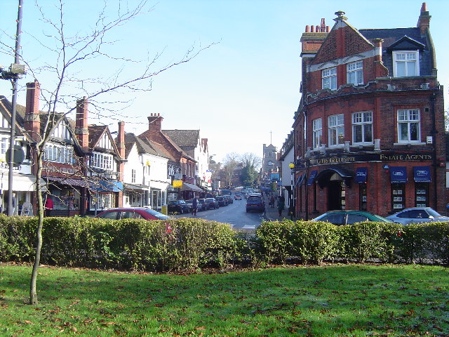
Originally a mediaeval hamlet, the St John Baptist church dates from the 14th century and other parts of the historic village include Tudor buildings. The newer High Street is mainly 18th-century buildings, while Bridge Street has a more urban character and many chain stores.
History
[edit]
Pinner was originally a hamlet, first recorded in 1231 as Pinnora,[3]: 11 although the already archaic -ora (meaning 'hill') suggests its origins lie no later than circa 900.[3]: 1 The name Pinn is shared with the River Pinn, which runs through the middle of Pinner. Another suggestion of the name is that it means 'hill-slope shaped like a pin'.[4]
The oldest part of the town lies around the fourteenth-century parish church of St. John the Baptist, at the junction of the present day Grange Gardens, High Street and Church Lane. The church was originally a chapel of ease to St Mary's Church, Harrow on the Hill, and was first mentioned in 1234. It was rebuilt in the early fourteenth-century, and rededicated in 1321. The parish became independent of St Mary's in 1766, when the first perpetual curate was appointed; not until the Wilberforce Act[which?] of 1868 did it appoint its first vicar, one William Hind.[3]: 34 The earliest surviving private dwelling, East End Farm Cottage, dates from the late fifteenth century.[3]: 18
The village expanded rapidly between 1923 and 1939, when a series of garden estates, including the architecturally significant Pinnerwood estate conservation area – encouraged by the Metropolitan Railway – grew around its historic core.[3]: 176–184 It was largely from this time onwards that the area (including Hatch End, which forms the northeastern part of Pinner) assumed much of its present-day suburban character. The area is now contiguous with neighbouring suburban districts including Rayners Lane and Eastcote.
Pinner contains a large number of homes built in the 1930s Art Deco style, the most grand of which is the Grade II listed Elm Park Court at the junction of West End Lane and Elm Park Road.[3]: 25 Pinner is also the site of one of the UK's oldest chartered fairs, called Pinner Fair, which has been held annually since 1336.[5]
Pinner lay within the historic county of Middlesex; it was located at the western end of the hundred of Gore, before it was in the Hendon Rural District.[6] In 1965 it became a part of the London Borough of Harrow in the newly formed ceremonial county of Greater London.[7]
Parish church
[edit]Pinner's St John the Baptist parish church was consecrated in 1321, but built on the site of an earlier Christian place of worship. The west tower and south porch date from the 15th century.[8]
Governance
[edit]Harrow Council has been governed by the Conservative Party since 2022. Pinner has two wards, Pinner and Pinner South, each represented by three Conservative councillors. Pinner is in the Brent and Harrow constituency for the London Assembly which has been represented since 2024 by Krupesh Hirani (Labour). Since the 2010 general election, Pinner has been part of the Ruislip, Northwood and Pinner parliamentary constituency, currently served by David Simmonds.[9]
Geography
[edit]
Pinner includes Pinner Village at its centre, along with the localities of Pinner Green and Pinnerwood Park Conservation Area[10] to the north. To the north east is the larger area of Hatch End, served by Hatch End railway station (originally opened as Pinner).
The River Pinn flows through Pinner, flowing in a diagonal direction. Large parks and open spaces are Pinner Memorial Park, Pinner Village Gardens, Roxbourne Gardens, Pinner Wood (woodlands) and Pinner Park (farmland).
Pinner Memorial Park has a large house in it which includes a museum to Illustrator Heath Robinson as well as a cafe which hosts regular music events throughout the summer; while Roxbourne Gardens also hosts a pop-up cafe and music venue on Sundays year-round.
Much of Pinner has an elevation of about 148 feet (45 m) to 200 feet (60 m). Nower Hill rises to a peak of about 260 feet (80 m) above sea level while Pinner Park peaks at 203 feet (62 m). The semi-rural Pinnerwood area is steep, and rises to a peak of over 390 feet (120 m) around Pinner Hill Golf Course.
Neighbouring communities | |
|---|---|
Demography
[edit]
Pinner is both a religiously and culturally mixed area, with the ethnic minority population having grown significantly since the 1970s.[11] Pinner ward nonetheless had the highest concentration of people describing themselves as white in the London Borough of Harrow, at 72 per cent of the population in 2011. In 2013 the Pinner South ward had the next highest proportion of white people in the borough at 69.4 per cent.[12] Various churches, a synagogue and others serve the religious needs of the community.
Pinner also has several independent schools and single-sex schools.[13] In the 2014/15 period, the Pinner South ward had a crime rate of 24.5, which was the lowest out of all 628 wards of Greater London.[14] The ward also has (data from 2009 to 2013) the second highest female life expectancy in the capital: 91.7 years, only bettered by Holland ward in Kensington and Chelsea.[14]
Fairs and fetes
[edit].jpg)
Pinner holds a number of fairs and fetes that are renowned in north west London for bringing its diverse and cosmopolitan community together.
Pinner Fair has been held annually since 1336, when it was granted by Royal Charter by King Edward III. The fair still draws thousand of people and families from Pinner and the surrounding areas in North West London.[15][16] The Pinner Fair was cancelled in 2020 and 2021 due to the COVID-19 pandemic, but the fair's charter was preserved.[17] To keep the annual tradition going, a small selection of non-operational rides were put up in 2020, and the Vicar came out to bless the showmen.[18][19]
Pinner Donkey Derby and Fete, held between 1925 and 1939 was a Charity event organised by Rev. John Caulfield, parish priest of St. Luke's, Pinner and Steve Donoghue, a leading flat-race jockey. Huge crowds would turn up to see the Derby, as it was also a chance to see celebrities and sporting personalities of the era.[20][21][22]
St. George’s Day annual celebrations are organised by the Rotary Club of Pinner and features the "Ye Olde Wheelbarrow Race".[23]
Sport and leisure
[edit]Pinner has a rugby union team, Pinner and Grammarians RFC, a member club of the Rugby Football Union. It is the most junior team to have supplied a President to the RFU.[24] Pinner also has a cricket team, Pinner Cricket Club,[25] and a youth football club, Pinner United FC.[26] The area also has a golf course, Pinner Golf course.[27]
In addition to numerous restaurants and a number of public houses, Pinner has an amateur theatre group, Pinner Players, who have been performing in the area since 1936 and currently stage productions at Pinner Village Hall[28] off Chapel Lane.[29]
The Heath Robinson Museum in Pinner Memorial Park was opened in 2016 and is dedicated to the work of the cartoonist William Heath Robinson.
In popular culture
[edit]Literature
[edit]Edward Lear makes reference to Pinner[30] in More Nonsense Pictures, Rhymes, Botany, etc:
There was an old person of Pinner,
As thin as a lath, if not thinner;
They dressed him in white,
And roll'd him up tight,
That elastic old person of Pinner.
H. G. Wells mentions Pinner in The War of the Worlds:
He learned they were the wife and the younger sister of a surgeon living at Stanmore, who had come in the small hours from a dangerous case at Pinner, and heard at some railway station on his way of the Martian advance.
Broadcast media
[edit]- The Pinner Fair held in Pinner High Street features in Sir John Betjeman's 1973 BBC film Metro-Land.[31]
- The BBC sitcom May to December (1989–1994) was set in Pinner.[32]
- During the 1990s the children's TV series Aquila was filmed in and around Pinner, particularly at the local Cannon Lane School.[citation needed]
- Chucklevision, the children's TV series based on the Chuckle Brothers was also filmed in Pinner.[citation needed]
- Between 2000 and 2006 Pinner was used for location footage for BBC sitcom My Hero, starring Ardal O'Hanlon as Thermoman.[33]
- Channel 4's coming-of-age television teen sitcom The Inbetweeners, Season 1 (2008), Episode 2 "Bunk Off" was filmed on the High Street in Pinner.[34]
- The 2009 film Nowhere Boy had a number of scenes filmed in Pinner, including outside the Queens Head Pub, Pinner High Street,[35]
- The 2012 film May I Kill U?, written and directed by Stuart Urban and starring Kevin Bishop, was also filmed in Pinner.[36]
- The documentary series, Great British Railway Journeys, Series 6 (2015), Episode 6, "Amersham to Regent's Park" features Michael Portillo in Pinner, where he finds out about a Victorian domestic goddess (Isabella Beeton) and whips up a pint of her fanciest ice cream.[37]
- BBC Radio 1's 24 Years at the Tap End (2011–) is Chris Stark's memoir of growing up in and around Pinner during the turn of the millennium.[38]
- BBC Radio 5 Live's hit podcast That Peter Crouch Podcast (2018–) has many references to Pinner, Hatch End and the surrounding areas.[39]
- Rocketman (2019), the biographical musical film based on the life and music of British musician Elton John, had a number of scenes filmed in and around Pinner. Oakmeade substituted for Pinner Hill Road as Elton John's childhood home[40] and Albury Drive as his father's home.
- The British dark comedy-drama spy thriller television series Killing Eve's Season 3 (2020), Episode 5, is titled "Are You from Pinner?". This is in reference to the character Bor'ka's fondness of Elton John.[41][42]
Notable people
[edit]This section needs additional citations for verification. (October 2021) |

- Ronnie Barker and David Suchet were both one-time owners of 17th-century Elmdene in Church Lane.[43]
- Samuel and Isabella Beeton lived on the Woodridings estate between 1856 and 1862, during which time Mrs Beeton's Book of Household Management was published.[3]: 155
- Derek Bell, motor racing driver, was born in Pinner.[44]
- Edward Bulwer-Lytton wrote Eugene Aram at Pinner Wood House in 1832.[45]
- Ivy Compton-Burnett, Victorian novelist, feminist, satirist, was born in the village in 1884.[46]
- Daniel Dancer, the famed miser, was born in here in 1716.
- Charlie Dore, singer, was born here.[citation needed]
- Jo Durden-Smith, British documentary film maker, writer and journalist, was born here in 1941.[47]
- Daniel Finkelstein is a Pinner resident and was created Baron Finkelstein of Pinner in 2013.[48]
- W. S. Gilbert was a magistrate in Pinner from 1893 onwards.[49]
- Martin Gould, professional snooker player.[citation needed]
- Tony Hatch, composer of the Petula Clark hit "Downtown" and many other television themes, including the Neighbours theme, was born here.[50]
- Bob Holness, the former host of quiz show Blockbusters, lived here.[51]
- Peter Jacobs, Olympic fencer, was born here in 1938.[52]
- Elton John, singer and songwriter grew up in Pinner Green and was educated at Pinner Wood Junior School, Reddiford School and Pinner County Grammar School.[53][54]
- Norman Kember, Christian pacifist activist and emeritus professor of biophysics, is a longtime resident of the town.[55]
- Brian Lane, pilot, (1917–1942) grew up in the village.[56]
- Lee Latchford-Evans, singer, dancer, stage actor, and one of the five members of the British pop group Steps, lives and works in Pinner.[57]
- Simon Le Bon, vocalist of post-punk rock band Duran Duran, grew up locally and attended the Pinner County Grammar School.[citation needed]
- Liza Lehmann, composer, lived at 'Nascot', Waxwell Lane, Pinner for several years after her marriage to Herbert Bedford in 1894.
- Caroline Alice Lejeune, film critic, lived here with her husband Edward Roffe Thompson, a journalist.
- Jane March, actress and model, grew up here before moving to the United States. Earlier in her career, March was referred to in the press as "The Sinner From Pinner".[58]
- Agnes Marshall, a celebrity chef and culinary entrepreneur, who published the first certain mention of eating ice cream from a cone,[59] had a country home there and died there in 1905.[60]
- Patrick Moore, the television presenter and astronomer, was born in Pinner in 1923.[61]
- Horatia Nelson, daughter of Lord Nelson and Lady Emma Hamilton, lived in Pinner from 1860 until her death in 1881.[3]: 155
- Lucy Porter, comedian, actress and writer lives in Pinner.[62]
- Henry James Pye (poet laureate) retired to East End House in 1811.[3]: 11
- Joseph Raphson, mathematician, probably[weasel words] baptised at Pinner church.[63]
- Heath Robinson, cartoonist, illustrator and artist, lived in Moss Lane, Pinner between 1913 and 1918.[3]: 192 The Heath Robinson Museum is in Pinner Memorial Park.[64]
- Michael Rosen, poet and children's author, lived in Pinner from the time he was born, in 1946, until 1962.[65]
- Chris Roycroft-Davis, journalist (The Sun) is a resident.
- Chris Stark, radio presenter grew up in and around Pinner.[citation needed]
- David "Screaming Lord" Sutch, who lived in nearby South Harrow, is buried in Pinner New Cemetery.[66]
- Gordon Waller of Peter and Gordon lived with his family in the house called Elton, Elm Park Road, and went to St John's prep school before boarding at Westminster School.
- Molly Weir, best known for her role as the long-running character Hazel the McWitch in the BBC TV series Rentaghost, lived in Pinner until her death in 2004.[67]
- Bruce Welch, guitarist in The Shadows, lived in Pinner.
- Maude Valerie White, composer, lived in Love Lane, Pinner during the 1890s.
Transport
[edit]
Rail
[edit]Pinner Underground station was opened in 1885 and is on the Metropolitan line in London fare zone 5. In normal off-peak conditions the train takes approximately half an hour to Baker Street Underground station and approximately three-quarters of an hour to Aldgate Underground station.
Hatch End railway station was opened in 1842 and is on the London Overground Watford DC line in London fare zone 6. In normal off-peak conditions it roughly takes three-quarters of an hour to Euston railway station.
Buses
[edit]| Route | Start | End | Operator |
| 183 | Pinner, Bridge Street | Golders Green Bus Station | London Sovereign |
| H11 | Harrow Bus Station | Northwood, Mount Vernon Hospital, | London Sovereign |
| H12 | South Harrow Bus Station | Stanmore Station | London Sovereign |
| H13 | Ruislip Lido | Northwood Hills, St Vincent's Park | Metroline |
| 398[68] | Ruislip Station | Greenford, Hemery Road | London United Busways |
Public Transport in Pinner is governed by Transport for London.
Cycling
[edit]The Metropolitan Quietway Cycle Route runs through Pinner, as well as street-running cycle lanes on Pinner Road and Eastcote Road.[69]
Walking Trails
[edit]The Celandine Route from West Drayton terminates at Pinner Memorial Park.
Heritage
[edit]Harrow Heritage Plaques
[edit]The brown plaques are awarded by the Harrow Heritage Trust,[70] who secure the protection, preservation, restoration and improvement of the character and amenities of the London Borough of Harrow.
- Queen's Head Public House on the High Street.[71]
- Wax Well on Waxwell Lane.[71]
- Elthorne Gate on the High Street.[71]
- Grim's Dyke on Montesole Playing Fields.[71]
- Pinner House on Church Lane.[71]
- Pinner Hill Farm on Pinner Hill Road.[71]
English Heritage Plaques
[edit]London's blue plaques scheme, run by English Heritage,[72] celebrates the links between notable figures of the past and the buildings in which they lived and worked.
- Sir Ambrose Heal (1872–1959), "Furniture Designer and Retailer lived here 1901–1917", The Fives Court, Moss Lane[73]
- W. Heath Robinson (1872–1944), "Illustrator and comic artist lived here 1913–1918", 75 Moss Lane[74]
Architecture
[edit]The architecture in Pinner has evolved greatly over the centuries. The majority of the architecture is conserved by private residents or by Harrow council's Conservation Team.[75]
Norman, Gothic and Tudor architecture (1066–1603)
- Church of St John the Baptist on Church Lane[76]

- Shops and Restaurants on the High Street[77][78][79][80][81][82][83][84][85][86][87][88]
- Cottages and Farmhouse on Waxwell Lane[77][89][90][91]
- Dwellings on Moss Lane[92][93][94][95]
Georgian architecture (1714–1811)
- Pinner House on Church Lane[96]


- Shops, Restaurants and Public Houses on the High Street[97][98][99][100][101][102][103]
- Pinner Park Farm House on George V Avenue[104]
- Former Granary at Harrow Museum, originally located at Pinner Park Farm[105]
Victorian architecture (1837–1901)
- Pinner Station on Station Approach
- Pinner Police Station on Elm Park Road[106]

- Pinner Hill Farm on Pinner Hill Road[107][108][109]
- Pinner Hill Golf Club House on South View Road[110][111]
Metro-land architecture (1903–1939)
- Suburban prototypes on Cecil Park Estate[112][113][114]
- Tudor revival dwellings on Grange Estate[113][114]
- Arts and Crafts dwellings on Pinnerwood Park Estate[77]
- Cottages on Elm Park Road[115]
Art Deco architecture (1919–1939)
- Elm Park Court on Elm Park Road[77][116]
- Pinner Court on Pinner Road[77][117]
- Harrow Fire Station on Pinner Road[77]
- Pinner Wood School on Latimer Gardens[77][118]
Modern architecture (1945–1980)
- Roman Catholic Church of St Luke on Love Lane[119]
- Shops on Bishops Walk
- Shops on Barters Walk
- Dwellings on Nursery Road
Postmodern architecture (1980–present)
- Heath Robinson Museum in Pinner Memorial Park[120]
- Dwellings on Caulfield Gardens[121]
- Nursery in Montesole Playing Fields
- Flats on Marsh Road
See also
[edit]References
[edit]- ^ Pinner is made up of 3 wards in the London Borough of Harrow: Hatch End, Pinner, and Pinner South. "2011 Census Ward Population Estimates". Archived from the original on 22 February 2014. Retrieved 9 June 2014.
- ^ "2011 Census Ward Population Estimates". Archived from the original on 22 February 2014. Retrieved 9 June 2014.
- ^ a b c d e f g h i j Clarke, Patricia (2004). A History of Pinner. Chichester, West Sussex: Phillimore. ISBN 978-1860772870.
- ^ "Key to English Place-names". kepn.nottingham.ac.uk.
- ^ Gorman, Michael (8 June 2011). Broken Pieces: A Library Life, 1941-1978. American Library Association. ISBN 978-0-8389-1104-4.
- ^ "The hundred of Gore". British History Online. Retrieved 7 December 2022.
- ^ The London Government Order 1965 (Statutory Instrument). Parliament of the United Kingdom. 1965.
- ^ Ben Weinreb; Christopher Hibbert (1992). The London Encyclopaedia (reprint ed.). Macmillan. p. 745.
- ^ www.statistics.gov.uk Archived 20 February 2017 at the Wayback Machine. Retrieved 14 August 2008.
- ^ "Harrow – Pinnerwood Park Estate Conservation Area Appraisal 29 October 2008" (PDF). Harrow Council. Archived from the original (PDF) on 8 March 2021. Retrieved 19 December 2019.
- ^ Muir, Hugh (8 July 2016). "Black flight: how England's suburbs are changing colour". The Guardian. Retrieved 5 December 2016.
- ^ "A look at Harrow's wards: 2011 Census second release". Harrow Council. February 2013. Retrieved 5 December 2016.[permanent dead link]
- ^ "Pinner Guide". AllInLondon.co.uk. Retrieved 14 March 2012.
- ^ a b "Ward Profiles and Atlas – London Datastore".
- ^ "Thousands enjoy Pinner fair". Harrow Times. 29 May 2013. Retrieved 26 October 2020.
- ^ Pathé, British. "Annual Fair At Pinner". www.britishpathe.com. Retrieved 26 October 2020.
- ^ "FUN FAIR: Popular fair set to return to Pinner after two-year hiatus". My Local News. 7 May 2022. Retrieved 9 May 2022.
- ^ "Pinner Fair 2020 – the final word". The Pinner Association. 28 May 2020. Retrieved 18 November 2022.
- ^ "The Fair Must Go On!". The Pinner Association. 22 May 2020. Retrieved 18 November 2022.
- ^ "Obituary – from the Catholic Herald Archive". archive-uat.catholicherald.co.uk. Archived from the original on 26 October 2020. Retrieved 26 October 2020.
- ^ "Donkey Derby And Fete At Pinner". British Pathé. Retrieved 26 October 2020.
- ^ "The Donkey Derby". British Pathé. Retrieved 26 October 2020.
- ^ "Pinner St George's Day celebration". Pinner. 22 November 2018. Retrieved 26 October 2020.
- ^ "Rugby Football History". www.rugbyfootballhistory.com.
- ^ "Pinner Cricket Club home page". pinnercc.hitssports.com.
- ^ "Pinner United FC". pinner-utd-fc.
- ^ "PINNER HILL GOLF CLUB LTD". www.pinnerhillgc.co.uk.
- ^ "Pinner Village Hall: Available to hire for all occasions". www.pinnervillagehall.org.uk.
- ^ "Pinner Players Theatre Company". Pinner Players Theatre Company.
- ^ Lear, Edward (1872). More Nonsense Pictures, Rhymes, Botany, etc. London: R J Bush.
- ^ The Best of Betjeman (2000 ed.). Penguin Books. 2000. p. 228. ISBN 9780141184326.
- ^ Campbell, Mark (28 August 1999). "Torquay: the horrible truth". The Independent. Retrieved 16 March 2011.
- ^ My Hero (Comedy, Fantasy, Romance), Big Bear Films, 4 February 2000, retrieved 21 October 2020
- ^ Anderson, Gordon (1 May 2008), Bunk Off (Comedy), Kapital Entertainment, retrieved 21 October 2020
- ^ "December 2009 – Pinner High Street". Film London. Archived from the original on 16 December 2010. Retrieved 16 March 2011.
- ^ addictedtoeddieblogspot (7 October 2013). "October 2013". addictedtoeddieblogspot. Retrieved 18 January 2015.
- ^ "Great British Railway Journeys". BBC. Retrieved 21 October 2020.
- ^ "Scott Mills – 24 Years at the Tap End – Season 2". www.bbc.co.uk. Retrieved 21 October 2020.
- ^ "That Peter Crouch Podcast". BBC Radio 5 Live. Retrieved 21 October 2020.
- ^ "Rocketman Filming Locations: Pinner and Beyond". findthatlocation.com. Retrieved 8 May 2021.
- ^ Harrington, Delia (10 May 2020). "Killing Eve Season 3 Episode 5 Review: Are You From Pinner?". Den of Geek. Retrieved 16 July 2020.
- ^ Murphy, Shannon (10 May 2020), Are You from Pinner? (Action, Adventure, Drama, Thriller), retrieved 21 October 2020
- ^ Pinner Local History Archived 19 October 2016 at the Wayback Machine. Retrieved 12 August 2008
- ^ "Derek Bell". www.mshf.com. Retrieved 26 September 2025.
- ^ Pinner Local History Society Archived 21 February 2011 at the Wayback Machine. Retrieved 13 August 2008.
- ^ "Dame Ivy Compton-Burnett | Victorian novelist, feminist, satirist | Britannica". www.britannica.com. Retrieved 12 August 2008.
- ^ Obituary of Jo Durden-Smith, The Independent, 5 June 2007. Retrieved 14 August 2008.
- ^ The Lord Finkelstein, OBE, Debrett's. Retrieved 14 November 2013.[dead link]
- ^ Views of W. S. Gilbert Archived 25 October 2006 at the Wayback Machine. Retrieved 12 August 2008.
- ^ "International Songwriters Association (ISA) Songs And Songwriting • Tony Hatch Interview". www.songwriter.co.uk. Retrieved 26 September 2025.
- ^ BBC Kent: Profile of Bob Holness. Retrieved 13 August 2008.
- ^ "Peter Jacobs Olympic Results". sports-reference.com. Archived from the original on 18 April 2020. Retrieved 17 December 2010.
- ^ Elton John official website Archived 15 July 2010 at the Wayback Machine. Retrieved 12 August 2008.
- ^ "You could live in the house where Sir Elton John was born". Evening Standard. 12 June 2015. Retrieved 21 October 2020.
- ^ 'No word on fate of Iraq peace hostages', The Independent, 12 December 2005. Retrieved 14 August 2005.
- ^ Hardiman, David (28 September 2011). "Pinner War Veteran Brian Lane Remembered with Plaque Unveiling". Harrow Times. Retrieved 3 October 2024.
- ^ Proctor, Ian (24 September 2008). "Volent comedy' set in the mean streets of... here". MyLondon. Retrieved 6 February 2022.
- ^ Bradberry, Grace (23 January 2004). "The original sinner". The Evening Standard. Retrieved 19 October 2020.
- ^ Montague, Charlotte (2018). Women of Invention: Life-Changing Ideas by Remarkable Women. New York: Chartwell Books. p. 137. ISBN 978-0-7858-3500-4.
- ^ Weir, Robin (2004). "Marshall, Agnes Bertha (1855–1905)". In Matthew, H. C. G.; Harrison, Brian (eds.). Oxford Dictionary of National Biography. Oxford Dictionary of National Biography. Vol. 36 (online ed.). Oxford: Oxford University Press. p. 826. doi:10.1093/ref:odnb/67307. ISBN 0-19-861386-5. (Subscription, Wikipedia Library access or UK public library membership required.)
- ^ www.bbc.co.uk. Retrieved 13 August 2008.
- ^ "Lucy Porter: The Witham, Barnard Castle". The Northern Echo. 31 January 2017. Retrieved 6 February 2022.
- ^ O'Connor, J. J.; Robertson, E. F. "Joseph Raphson". MacTutor. Retrieved 14 March 2022.
- ^ "Heath Robinson Museum". Heath Robinson Museum. Retrieved 6 February 2022.
- ^ ":: Michael Rosen – The Website ::". 29 November 2016.
- ^ www.bbc.co.uk. Retrieved 13 August 2008.
- ^ The Gazetteer for Scotland. Retrieved 7 August 2008.
- ^ Route 398 serves stops in Pinner near its southern border, but not the town centre itself.
- ^ McGirr, Andrew. "Cycling in Harrow". London Borough of Harrow. Retrieved 7 June 2023.
- ^ "Harrow Heritage Trust". www.harrowheritagetrust.org.uk. Retrieved 16 October 2021.
- ^ a b c d e f "Plaques | Harrow Heritage Trust".
- ^ "Blue Plaques". English Heritage. Retrieved 11 November 2020.
- ^ "Ambrose Heal | Furniture Designer | Blue Plaques". English Heritage. Retrieved 11 November 2020.
- ^ "W. Heath Robinson | Illustrator | Blue Plaques". English Heritage. Retrieved 11 November 2020.
- ^ gangari, tariq. "Conservation". Harrow Council. Retrieved 27 October 2020.
- ^ "CHURCH OF ST JOHN THE BAPTIST, Harrow – 1286312 | Historic England". historicengland.org.uk. Retrieved 11 November 2020.
- ^ a b c d e f g gangari, tariq. "Conservation". Harrow Council. Retrieved 26 October 2020.
- ^ "THE VICTORY PUBLIC HOUSE, Non Civil Parish – 1286035 | Historic England". historicengland.org.uk. Retrieved 11 November 2020.
- ^ "7, HIGH STREET, Harrow – 1358633 | Historic England". historicengland.org.uk. Retrieved 11 November 2020.
- ^ "9, HIGH STREET, Harrow – 1193639 | Historic England". historicengland.org.uk. Retrieved 11 November 2020.
- ^ "11, HIGH STREET, Harrow – 1079698 | Historic England". historicengland.org.uk. Retrieved 11 November 2020.
- ^ "25–27, HIGH STREET, Harrow – 1193645 | Historic England". historicengland.org.uk. Retrieved 11 November 2020.
- ^ "26, HIGH STREET, Harrow – 1286041 | Historic England". historicengland.org.uk. Retrieved 11 November 2020.
- ^ "29, HIGH STREET, Harrow – 1079699 | Historic England". historicengland.org.uk. Retrieved 11 November 2020.
- ^ "33–35, HIGH STREET, Harrow – 1286059 | Historic England". historicengland.org.uk. Retrieved 11 November 2020.
- ^ "34, 34A, 36, HIGH STREET, Harrow – 1358634 | Historic England". historicengland.org.uk. Retrieved 11 November 2020.
- ^ "BARN TO SOUTH OF NUMBER 38, Harrow – 1079705 | Historic England". historicengland.org.uk. Retrieved 11 November 2020.
- ^ "58, HIGH STREET, Harrow – 1193713 | Historic England". historicengland.org.uk. Retrieved 11 November 2020.
- ^ "BEE COTTAGE, Harrow – 1079660 | Historic England". historicengland.org.uk. Retrieved 11 November 2020.
- ^ "WAXWELL FARMHOUSE, Harrow – 1079661 | Historic England". historicengland.org.uk. Retrieved 11 November 2020.
- ^ "MANOR COTTAGE MANOR HOUSE WAXWELL COTTAGE, Harrow – 1079659 | Historic England". historicengland.org.uk. Retrieved 11 November 2020.
- ^ "TUDOR COTTAGE, Harrow – 1079672 | Historic England". historicengland.org.uk. Retrieved 11 November 2020.
- ^ "EAST END FARM COTTAGE, Harrow – 1358620 | Historic England". historicengland.org.uk. Retrieved 11 November 2020.
- ^ "EAST END HOUSE, Harrow – 1358657 | Historic England". historicengland.org.uk. Retrieved 11 November 2020.
- ^ "EAST BARN TO EAST END FARM (PREMISES TO MCPHAIL BROS), Harrow – 1193851 | Historic England". historicengland.org.uk. Retrieved 11 November 2020.
- ^ "PINNER HOUSE, Harrow – 1358615 | Historic England". historicengland.org.uk. Retrieved 11 November 2020.
- ^ "18–24, HIGH STREET, Harrow – 1079703 | Historic England". historicengland.org.uk. Retrieved 11 November 2020.
- ^ "The Queen's Head, Non Civil Parish – 1079700 | Historic England". historicengland.org.uk. Retrieved 11 November 2020.
- ^ "32, HIGH STREET, Harrow – 1079704 | Historic England". historicengland.org.uk. Retrieved 11 November 2020.
- ^ "37, HIGH STREET, Harrow – 1079701 | Historic England". historicengland.org.uk. Retrieved 11 November 2020.
- ^ "The Hand in Hand Public House, Harrow – 1193708 | Historic England". historicengland.org.uk. Retrieved 11 November 2020.
- ^ "39, HIGH STREET, Harrow – 1079702 | Historic England". historicengland.org.uk. Retrieved 11 November 2020.
- ^ "HAYWOOD HOUSE, Harrow – 1079706 | Historic England". historicengland.org.uk. Retrieved 11 November 2020.
- ^ "PINNER PARK FARMHOUSE, Harrow – 1079715 | Historic England". historicengland.org.uk. Retrieved 11 November 2020.
- ^ "Former Granary at Headstone Manor, Non Civil Parish – 1420464 | Historic England". historicengland.org.uk. Retrieved 11 November 2020.
- ^ "Pinner Police Station including stable block, boundary wall, gate pier and fences, bollards and police lamps, Non Civil Parish – 1411163 | Historic England". historicengland.org.uk. Retrieved 27 October 2020.
- ^ "TOOKE'S FOLLY AT PINNER HILL FARM, Harrow – 1079682 | Historic England". historicengland.org.uk. Retrieved 11 November 2020.
- ^ "BARNS ON SOUTH AND WEST SIDES OF YARD AT PINNER HILL FARM, Harrow – 1194027 | Historic England". historicengland.org.uk. Retrieved 11 November 2020.
- ^ "PINNER HILL FARMHOUSE AND BRICK BARN TO REAR, Harrow – 1079681 | Historic England". historicengland.org.uk. Retrieved 11 November 2020.
- ^ "A Brief History of Pinner Hill (researched and written by Ellie Pithers)". www.pinnerhill.org. Archived from the original on 31 October 2020. Retrieved 27 October 2020.
- ^ "PINNER HILL GOLF CLUB HOUSE, AND BOUNDARY WALL EXTENDING NORTHWARDS FROM CLUB HOUSE, Harrow – 1358625 | Historic England". historicengland.org.uk. Retrieved 11 November 2020.
- ^ "Metroland: the golden age of mock Tudor | MIDDLESEX: A ROUNDTRIP IN NOWHERE LAND". Archived from the original on 6 June 2019. Retrieved 11 November 2020.
- ^ a b Green, Oliver. (1987). The London Underground : an illustrated history. London: Ian Allan in association with the London Transport Museum. ISBN 0-7110-1720-4. OCLC 59997780.
- ^ a b Jackson, Alan Arthur. (1986). London's metropolitan railway. Newton Abbot: David & Charles. ISBN 0-7153-8839-8. OCLC 16277029.
- ^ "TUDOR COTTAGE, Harrow – 1253922 | Historic England". historicengland.org.uk. Retrieved 11 November 2020.
- ^ "ELM PARK COURT, AND ENTRANCE ARCH, Harrow – 1261409 | Historic England". historicengland.org.uk. Retrieved 11 November 2020.
- ^ "PINNER COURT, Harrow – 1254195 | Historic England". historicengland.org.uk. Retrieved 11 November 2020.
- ^ "Our History". PWS. Archived from the original on 22 October 2020. Retrieved 11 November 2020.
- ^ "Roman Catholic Church of St Luke, Non Civil Parish – 1429922 | Historic England". historicengland.org.uk. Retrieved 11 November 2020.
- ^ "Heath Robinson Museum". www.heathrobinsonmuseum.org. Retrieved 11 November 2020.
- ^ "Final phase of five year regeneration begins". Catalyst housing association London and South East. 30 October 2014. Archived from the original on 27 October 2020. Retrieved 27 October 2020.
External links
[edit]| Districts |
|   | ||
|---|---|---|---|---|
| Attractions | ||||
| Parks and open spaces | ||||
| Constituencies | ||||
| Tube and rail stations | ||||
| Other topics | ||||
| International | |
|---|---|
| National | |
| Geographic | |
| Other | |
Pinner
View on GrokipediaHistory
Origins and Medieval Period
Pinner originated as a Saxon settlement, with its name deriving from Old English elements suggesting a location on a bank or edge, as evidenced by its early recording as Pinnora in 1231 or 1232.[8][4] The archaic suffix -ora, meaning "bank" or "ridge," indicates pre-Norman roots tied to the local topography near the River Pinn, though the settlement itself is not explicitly listed in the Domesday Book of 1086, which instead records the broader Harrow manor encompassing it.[1] As one of the ten hamlets comprising the medieval manor of Harrow, Pinner functioned as a rural agricultural community under the lordship of Harrow, where tenants rented land or labored in exchange for holdings.[1] The manor's demesne included significant properties such as Woodhall Farm, Headstone Manor (with its surviving moated house and barn), and Pinner Park, a 250-acre deer enclosure protected by banks and ditches to preserve game for the lord's hunt.[1] Villagers cultivated subdivided fields south of the settlement, with commons and woodlands to the north, reflecting a typical open-field system of medieval agrarian organization. The Parish Church of St. John the Baptist, central to early Pinner, was rebuilt in flint and consecrated in 1321 as a chapel of ease subordinate to Harrow's ancient church, marking a key development in local ecclesiastical independence.[9] By the 1230s, records confirm the presence of a church structure, underscoring Pinner's established community by the early 13th century.[1] In 1336, King Edward III granted a midsummer fair to be held outside the church on the feast of St. John the Baptist, fostering economic activity through trade and markets amid the hamlet's growing cohesion.[1] These elements highlight Pinner's evolution from a peripheral hamlet to a nucleated village within the feudal framework of Harrow manor during the medieval period.Post-Medieval Development
In the 16th and 17th centuries, Pinner evolved from a medieval hamlet into a more established village centered on agriculture and emerging crafts, with timber-framed buildings constructed along the High Street, including the Queen's Head and Victory public houses.[10] These structures, often incorporating jettied upper stories and pargeted facades, reflect the period's vernacular architecture and the growing presence of trades such as butchery, baking, and lace-making, the latter becoming a notable local industry that drew workers and merchants.[2] [11] Pinner Fair, originally granted a charter in the medieval era, expanded as a hub for lace trade during this time, fostering economic ties beyond subsistence farming.[11] Prominent figures contributed to localized development; Sir Christopher Clitherow, Lord Mayor of London in 1635, constructed a mansion on Pinner Hill, exemplifying how affluent Londoners invested in rural Middlesex estates for leisure and status.[1] Around the same period, the lord of Harrow Manor sold off estates including Woodhall, Headstone, and Pinner Park, fragmenting larger holdings and enabling smaller-scale farming and residential use.[1] By the mid-17th century, the village supported a community of tradespeople operating from home workshops, alongside its core agrarian economy of arable and dairy production on fertile lands watered by local streams.[1] The 18th century saw modest continuity in this rural character, with population growth remaining gradual and building limited to infill on existing lanes; surviving barns and farmhouses from this era underscore Pinner's role as a peripheral supplier to London's markets, though without significant industrialization or enclosure until later.[12] Enclosures, such as those at Pinner Hill in the early 1800s, marked the transition toward more intensive land use, but pre-1800 development prioritized maintenance of the village core over expansion.[13]19th and 20th Century Growth
During the 19th century, Pinner transitioned from a predominantly rural settlement to an emerging suburb, with population growth reflecting national trends but remaining modest initially. The census recorded 761 residents in 1801, rising to 1,310 by 1851, supported by agricultural stability and limited local trade.[2] The arrival of the railway in 1885, via the extension of the Metropolitan Railway line, catalyzed further development by enabling daily commuting to central London, transforming Pinner into a dormitory suburb.[14] This infrastructure spurred residential and commercial expansion along the High Street, where frontages were progressively closed and rebuilt by 1880 to accommodate increasing footfall from tradespeople and incoming Londoners.[2] By 1911, the population had increased dramatically to 7,103, underscoring the railway's impact on attracting middle-class households seeking rural amenities near the capital.[2] The 20th century accelerated Pinner's suburbanization, particularly during the interwar period, as part of the "Metroland" marketing by the Metropolitan Railway Company, which promoted semi-rural estates accessible by tube.[4] Residential development boomed between 1923 and 1939, with large-scale construction of semi-detached houses on former farmland, exemplified by estates along roads like George V Avenue, drawing artists, writers, and professionals to its tranquil yet connected setting.[1][14] This era saw Pinner's High Street evolve into a bustling local hub with shops and services, while population growth continued post-World War II, solidifying its status as a affluent commuter enclave within the expanding London Borough of Harrow.[2] By the mid-20th century, restrictions on further infilling preserved much of the village character amid broader urbanization pressures.[2]Recent Historical Preservation
In response to threats of insensitive modernization during the mid-20th century, local campaigns in Pinner successfully advocated for the protection of its historic High Street and Bridge Street in 1968, preserving timber-framed buildings dating from the 16th and 17th centuries that originally served as inns and workshops.[15] This initiative marked an early focus on retaining the area's medieval village character amid suburban expansion.[15] The London Borough of Harrow designated multiple conservation areas within Pinner to safeguard its architectural and historic interest, with the Pinner Conservation Areas Supplementary Planning Document adopted in December 2009 providing guidance on their management.[16] [17] These include Pinner High Street, Pinner Hill Estate (covering 30 hectares), and Pinnerwood Park Estate (27 hectares), emphasizing distinct identities formed by inter-war housing and earlier vernacular structures.[16] Strict planning guidelines enforce preservation, as seen in Pinner Hill's conservation status, which restricts developments to maintain the area's early 20th-century domestic architecture and town planning.[18] [19] A notable restoration project involved West House in Pinner Memorial Park, a historic building threatened with demolition but saved through community efforts led by the Pinner Association and trustees; following extensive renovations, it reopened in June 2010 as the home of the Heath Robinson Museum.[20] [21] [22] Increased awareness of historic value has driven further restorations along Pinner High Street, where properties underwent refurbishment to retain their picturesque qualities while adapting to modern uses, such as a recent medical centre development that preserved surrounding historic elements.[2] [2] Local organizations, including the Pinner Local History Society established to promote research and public interest in the area's heritage, continue to support preservation through talks, visits, and advocacy against incompatible developments.[23] Preservation societies and Harrow Council collaborate to ensure Pinner's architectural heritage endures, balancing conservation with contemporary needs in these designated zones.[14]Geography
Location and Administrative Boundaries
Pinner is a suburban locality in the northwestern sector of Greater London, situated within the London Borough of Harrow, approximately 12.5 miles (20.1 km) northwest of Charing Cross.[24] Its central coordinates are 51.5938°N 0.3822°W.[25] Administratively, Pinner functions as an electoral ward, designated as Pinner Ward (E05013555), under the governance of the London Borough of Harrow.[26] The borough, established in 1965 through the London Government Act 1963, absorbed areas previously in the historic county of Middlesex, including Pinner, into the new administrative structure of Greater London.[4] The ward's boundaries are delineated by Harrow Council and encompass residential, commercial, and green areas, adjoining other local wards such as Hatch End to the north and Pinner South to the southeast, while sharing an external border with the London Borough of Hillingdon to the west.[27] These boundaries have been periodically reviewed, with updates reflected in council ward maps, such as those from 2019 and proposed revisions for 2022. Pinner lacks separate parish status, aligning with the unparished nature of most Greater London areas under the authority of the borough council and the Greater London Authority.[28]Topography and Natural Features
Pinner's topography consists of undulating terrain shaped by the underlying London Clay Formation, with higher elevations concentrated around Pinner Hill and adjacent areas like Pinner Cemetery.[16] Pinner Hill itself rises to 134 meters above sea level, capped by pebble gravels that enhance its prominence amid the surrounding clay plateau.[16] The London Clay, an Eocene deposit reaching depths of about 100 meters beneath sites like Pinner Park Farm, forms the dominant substrate, interrupted locally by Reading Beds near watercourses.[16] The River Pinn, a tributary of the Colne originating in nearby Harrow Weald, traverses Pinner, providing a key hydrological feature that supports riparian habitats despite sections being culverted for urban development; it emerges visibly near Pinner High Street and Pinner Park Farm.[16] [29] Subsurface geology includes chalk workings, as evidenced by the Pinner Chalk Mines—a Regionally Important Geological Site featuring shafts up to 34 meters deep, the deepest known chalk mine shaft in the UK, located near Pinner Hill Farm.[16] [30] Vegetative natural features encompass ancient woodlands such as Pinner Wood, spanning approximately 2 hectares with characteristic species including ash, oak, hornbeam, and beech, remnants of historic parkland integrated into the semi-rural landscape.[30] Adjacent areas like Oxhey Wood and Nanscot Woods contribute to dense greenery, mature tree cover, and diverse flora-fauna assemblages, preserving ecological continuity amid suburban pressures.[30] These elements, including hedgerows and grass verges, underscore Pinner's transition from clay-dominated lowlands to gravel-capped elevations, fostering views across the broader Harrow landscape.[30]Urban and Green Spaces
Pinner maintains a balance between suburban urban development and extensive green spaces, preserving its village-like character within the London Borough of Harrow. The borough manages 80 green spaces, including parks, nature reserves, and open lands, several of which are located in or near Pinner.[31] Pinner Memorial Park, situated centrally with entrances on West End Lane, West End Avenue, and Chapel Lane, features a pond supporting ducks and geese, a bowling green, an aviary, playground equipment, an outdoor gym, and diverse habitats such as woodland patches, hedges, and mature trees including native and exotic species like larch and weeping willow.[32][33][34] This park holds Green Flag status, recognizing high-quality management and facilities accessible to all, including baby changing and dog-friendly areas.[33][34] Additional green areas include Pinner Recreation Ground, offering recreational facilities, and Roxbourne Park on Cannon Lane, which provides paths for walking and jogging alongside children's play areas.[35][36] Pinner Village Gardens contribute to the local network of open spaces. Farmland persists on the periphery, supporting the area's semi-rural topography. Urban spaces emphasize conservation, with Pinnerwood Park Estate—a 1920s garden suburb in Arts and Crafts style—covering 27 hectares, and Pinner Hill Estate spanning 30 hectares as key protected zones.[16][37] These areas integrate low-density housing with green buffers, limiting intensive development while accommodating suburban expansion since the 19th century.[16][38] The High Street serves as the urban core, blending historic structures with modern commerce amid leafy surroundings.[38]Governance
Local Administration
Pinner is administered by the London Borough of Harrow Council, the unitary local authority responsible for delivering public services across the borough, including council tax collection, planning permissions, housing allocation, social care, waste collection, and leisure facilities.[39] The council operates from its main offices at the Council Hub on Kenmore Avenue in Harrow, with full council meetings convened at the Harrow Arts Centre in Pinner.[40] Following the Local Government Boundary Commission's review and boundary changes effective from the 2022 elections, Harrow comprises 22 wards electing a total of 55 councillors, with each ward represented by either two or three members depending on population size.[41] [42] The Pinner area specifically falls under the Pinner and Pinner South wards, each electing three councillors to represent local interests on the borough council.[43] These wards handle resident concerns through mechanisms such as monthly surgeries held at Pinner Library on Marsh Road, where councillors address issues like parking, maintenance, and community services.[44] Pinner lacks a separate civil parish or town council, with all administrative functions centralized at the borough level, ensuring uniform application of policies without sub-local governance layers.[45] As of the 2022 local elections, representation in these wards is held by Conservative Party councillors, including Paul Osborn and Norman Stevenson for Pinner ward, and June Baxter and Hitesh Karia for Pinner South ward, reflecting the party's majority control of the council at 31 seats to Labour's 24.[46] [47] This structure facilitates decision-making via cabinet-style governance, where a leader and portfolio holders oversee departments, supported by scrutiny committees for oversight.[48] Local planning applications and enforcement in Pinner, for instance, are processed through the borough's development control committee, adhering to national and borough-wide planning frameworks.Political Dynamics and Representation
Pinner is represented in the UK Parliament by the Ruislip, Northwood and Pinner constituency, which encompasses the area along with parts of the London Borough of Hillingdon. The seat has been held by David Simmonds of the Conservative Party since 2019.[49] In the July 4, 2024, general election, Simmonds received 21,366 votes (45.4% share), securing a majority of 7,581 over Labour candidate Tony Gill's 13,785 votes (29.3% share), despite a 9.9 percentage point decline in the Conservative vote share from 2019.[50] At the local level, Pinner is divided between the Pinner and Pinner South wards of Harrow London Borough Council, which elects 55 councillors across 22 wards every four years. In the May 5, 2022, local elections, the Conservative Party retained control of both wards. In Pinner ward, Norman Shairp Stevenson (Conservative) was re-elected with 1,979 votes (46.6% share under first-past-the-post for the three seats), contributing to a narrow hold amid a turnout of 39%.[51] Pinner South ward saw June Rosemary Baxter (Conservative) elected with 2,418 votes (18% in the multi-member contest), with Conservatives securing two of the three seats and a majority of 1% over Labour.[52] These results aligned with the Conservative Party's overall majority on Harrow Council, holding 34 of 55 seats post-2022.[53] Pinner residents are also represented in the Greater London Assembly by the Harrow and Brent constituency member, currently Kirsten Johnson of the Conservative Party, elected in 2024 with 58,000 votes (44.5% share). Local political dynamics in Pinner reflect a consistent Conservative preference, evidenced by vote shares exceeding 45% in recent parliamentary and assembly contests, though national shifts in 2024 narrowed margins compared to prior elections.[50] Key issues in council representation include resident concerns over planning, green belt preservation, and infrastructure, with Conservative councillors advocating for restrained development to maintain the suburb's semi-rural character.Economy
Employment Patterns
Pinner ward records a low long-term unemployment rate of 1.6 per 1,000 working-age population for the period 2019/20, substantially below typical urban averages and indicative of robust local labor market stability.[54] This aligns with the area's elevated median household income of £43,000 (2012/13 estimate), surpassing the Harrow borough average of £38,000 and reflecting higher earning potential among residents.[54] Census 2021 data for sub-areas like Pinner Green highlight a predominance of professional and managerial roles, with managers, directors, and senior officials forming the largest occupational group, while elementary occupations represent the smallest share.[55] Specific lower super output areas (LSOAs) within Pinner, such as Harrow 009D, show 23.8% of residents in higher managerial and professional occupations—10.5 percentage points above the London average—underscoring a skew toward skilled, knowledge-based employment.[56] Employment deprivation in Pinner remains minimal, with LSOA scores as low as 0.028 (ranking 30,995 out of 32,844 nationally in the Indices of Deprivation), pointing to limited barriers to workforce participation compared to more deprived urban zones.[57] Within the encompassing Harrow borough, the overall employment rate for ages 16-64 stood at 73.4% for the year ending December 2023, with Pinner's affluence likely contributing to rates at or above this benchmark through commuting to central London professional sectors.[58]Local Businesses and Commerce
Pinner's commerce is primarily concentrated along its High Street and adjacent Bridge Street, designated as a conservation area since 1968 to preserve over 20 historic timber-framed buildings. These streets host a blend of independent retailers, cafes, restaurants, and service providers catering to the local residential population and visitors drawn to the area's village-like charm. Supermarkets such as Sainsbury's, Marks & Spencer, Lidl, and Tesco anchor the retail landscape, while independent delis, interiors shops, and eateries provide specialized options.[15][37] The High Street features a notable increase in coffee shops, up 22% in recent years, alongside pubs like the Queen's Head, one of Pinner's oldest structures dating back centuries. Independent cafes such as Augustina's Tearoom and Kafe Ador, along with vegan options like Ahimsa, contribute to a diverse hospitality sector that includes both chains like Pizza Express and local establishments. This mix supports daily commerce for residents, with boutique stores, salons, and niche retailers adapting to modern trends amid challenges from rising rents and e-commerce competition.[37][59] Historically, the High Street evolved from medieval markets and fairs—Pinner Fair has operated annually since 1336—to 20th-century independent trades including greengrocers, butchers, and hardware stores, many family-run for generations. Contemporary shifts emphasize food, beauty services, and small offices, reflecting suburban economic patterns within the broader Harrow borough, which recorded 15,215 registered businesses in 2019. Local commerce sustains employment in retail and services, bolstering the area's affluent, family-oriented demographic without dominating the regional economy.[15][60]Demographics
Population Trends
The population of Pinner ward, as defined in the early 21st century, grew modestly from 9,601 residents in the 2001 census to 10,026 in 2011, an increase of 4.4% over the decade, reflecting limited expansion amid constrained suburban development.[61] This growth rate was below the 15.3% recorded for the wider London Borough of Harrow during the same period, attributable to factors such as established residential stock and preservation of green spaces limiting large-scale housing additions. Ward boundaries were redrawn by the Local Government Boundary Commission for England following a review concluded in 2019, with changes taking effect for the 2022 local elections; the revised Pinner ward now covers a broader area previously including elements of adjacent wards like Pinner South and Hatch End.[62] Under these new boundaries, the 2021 census enumerated 13,137 residents, implying an approximate annual growth of 0.67% from mid-2011 estimates when adjusted for the expanded footprint, though direct comparability across censuses is limited by the reconfiguration.[5] This trajectory aligns with Harrow's overall 9.3% decadal rise to 261,205 by 2021, driven by net migration and natural increase rather than aggressive infill development.| Census Year | Population (Pinner Ward) | Growth from Prior Decade | Notes |
|---|---|---|---|
| 2001 | 9,601 | - | Original boundaries[61] |
| 2011 | 10,026 | +4.4% | Original boundaries[61] |
| 2021 | 13,137 | Not directly comparable | Revised boundaries post-2019 review[5][62] |
Ethnic and Cultural Composition
According to the 2021 United Kingdom census, Pinner ward in the London Borough of Harrow had a population of 13,155, characterized by a diverse ethnic makeup reflecting post-1970s immigration trends in outer London suburbs.[5] The largest ethnic group was White, comprising 6,099 residents or 46.4% of the population, followed by Asian or Asian British at 5,097 residents or 38.7%.[5] Within the White category, British Whites accounted for approximately 35% of the total population, lower than the London average of 37%, indicating a notable presence of other White ethnicities such as Irish or European.[63]| Ethnic Group | Number of Residents | Percentage |
|---|---|---|
| White | 6,099 | 46.4% |
| Asian/Asian British | 5,097 | 38.7% |
| Black/Black British | 701 | 5.3% |
| Mixed/Multiple | ~1,065 | ~8.1% |
| Arab | 193 | 1.5% |
| Other | (remainder) | (balance) |
Socioeconomic Indicators
Pinner exhibits low levels of deprivation relative to national benchmarks. In the 2019 English Indices of Multiple Deprivation, Pinner South ward recorded the lowest overall deprivation score in the London Borough of Harrow, with an income deprivation rate of 8.6%, placing its lower-layer super output areas (LSOAs) among the least deprived in England.[65] Pinner ward similarly features minimal deprivation, with only two LSOAs identified as relatively more deprived within the borough, both ranking in the least deprived national deciles across domains such as income, employment, and education.[66] These rankings reflect structural advantages including high property values and professional employment concentrations, though they mask pockets of income disparity. Economic activity rates in Pinner ward stand at approximately 75-80% for working-age residents, lower than Harrow's borough average of 85% but aligned with patterns in suburban areas influenced by higher proportions of retirees and self-employed professionals.[54] Median gross weekly earnings for full-time employees residing in the Ruislip, Northwood, and Pinner constituency, which encompasses Pinner, were £575.50 as of recent labour market data, below London's £804.90 regional median but indicative of a commuter economy reliant on sectors like finance, IT, and healthcare in central London.[67] Unemployment remains low, with claimant rates under 2%, supported by proximity to Metropolitan line transport links facilitating access to high-wage opportunities.[67] Educational attainment is a strength, with residents showing elevated qualification levels. In Pinner ward, 69.6% of pupils achieved GCSE grades 5 or above in English and mathematics in 2018, the highest rate among Harrow wards and exceeding national averages.[68] Secondary schools such as Pinner High School report Attainment 8 scores of 55.1, with 61% of pupils securing grade 5 or above in English and maths, reflecting above-average progress in value-added metrics.[69] Adult qualification rates align with this, featuring high proportions holding degree-level or equivalent credentials, contributing to socioeconomic stability. Housing affordability poses challenges, with average property prices in Pinner reaching £799,500 as of 2025 data, a 12.7% year-on-year increase driven by demand for family homes in greenbelt-adjacent locations.[70] This elevates price-to-income ratios well above national medians, rendering homeownership difficult for median earners and fostering reliance on private rentals or inheritance, though owner-occupancy rates exceed 70% due to legacy holdings from earlier decades.[54]| Indicator | Pinner Ward Value | Comparator (Harrow/England) | Source |
|---|---|---|---|
| Income Deprivation Rate (2019 IMD) | 8.6% (Pinner South) | Harrow: ~10%; England: 20% | [65] |
| Economic Activity Rate (Working Age) | ~75-80% | Harrow: 85%; England: 82% | [54] |
| Median Weekly Earnings (Full-Time) | £575.50 | London: £804.90; UK: £640 | [67] |
| GCSE 5+ in Eng/Maths (Pupils) | 69.6% | Harrow average: ~65%; England: ~50% | [68] |
| Average House Price (2025) | £799,500 | London average: ~£520,000 | [70] |
Education
Primary and Secondary Schools
Pinner is served by several state-funded primary schools, primarily catering to children aged 3-11, with a mix of community, academy, and faith-based institutions under the London Borough of Harrow's oversight. Key establishments include Pinner Wood School, a community primary academy located at Latimer Gardens, Pinner HA5 3RA, which enrolled approximately 470 pupils as of recent data and achieved an Ofsted rating of Outstanding in December 2023 for its curriculum, pupil behavior, and leadership.[71] Pinner Park Primary School, comprising infant and junior sections at Melbourne Avenue, serves a diverse intake of over 600 pupils and reported 87% achieving expected standards in reading, 93% in mathematics, and 75% in combined reading, writing, and math in 2023 assessments.[72] Cannon Lane Primary School, at Cannonbury Avenue, was inspected in January 2025 and rated Outstanding across all categories, including quality of education, behavior and attitudes, personal development, and leadership, highlighting its strong academic outcomes and inclusive practices for its roughly 450 pupils.[73] Other notable primaries include St John Fisher Catholic Primary School, a voluntary aided faith school at Berkeley Avenue, HA5 5RA, emphasizing Catholic values alongside secular curriculum for about 240 pupils, with consistently high attainment in national tests.[74] Grimsdyke Primary School, bordering Pinner at Sylvia Avenue, Harrow Weald, serves local families with around 450 pupils and maintains strong performance metrics, though specific recent Ofsted details emphasize effective safeguarding and progress for disadvantaged pupils.[75] These schools generally outperform national averages in key stage 2 results, with Harrow borough primaries achieving 78% pupil proficiency in reading, writing, and math combined in 2023, attributed to selective admissions pressures and high parental engagement in the area.[76]| School Name | Type | Approximate Pupils | Ofsted Rating (Latest) |
|---|---|---|---|
| Pinner Wood School | Community Academy | 470 | Outstanding (2023)[71] |
| Pinner Park Primary | Community | 600+ | Good (implied by performance data, 2023)[72] |
| Cannon Lane Primary | Community | 450 | Outstanding (2025)[73] |
| St John Fisher Catholic | Voluntary Aided | 240 | Good[75] |
| School Name | Type | Age Range | Approximate Pupils | Ofsted Rating (Latest) |
|---|---|---|---|---|
| Pinner High School | Free School Academy | 11-18 | 1,200+ | Outstanding[78] |
| Nower Hill High | Academy Converter | 11-18 | 1,600 | Good[79] |
| Hatch End High | Community | 11-18 | 1,000+ | Good (performance-based)[80] |