
Community hub
Recent from talks
Contribute something
Nothing was collected or created yet.
Iver /ˈaɪ.vər/ is a civil parish in Buckinghamshire, England. In addition to the central clustered village, the parish includes the residential neighbourhoods of Iver Heath and Richings Park and the hamlets of Shreding Green and Thorney.[2]
Key Information


Geography, transport and economy
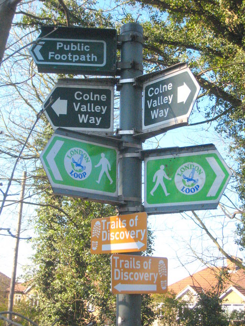
[edit]Part of the 43-square-mile Colne Valley regional park, with woods, lakes and land by the Grand Union Canal. Most of the open land is classified as Metropolitan Green Belt.
Surrounding the Ivers are neighbouring villages and towns of Fulmer, Denham, Gerrards Cross and Wexham. Also nearby are Colnbrook, Langley, Uxbridge, Cowley, Yiewsley and West Drayton.
The Ivers have public transport and motorway links. The M25 motorway passes east of the main village, west of Iver Heath and east of Richings Park, but cannot be accessed directly from the Ivers. Instead, road links are provided to junction 5 of the M4 motorway for Langley, and to junction 1 of the M40 motorway for Denham. The junction of the M4 with the M25 is named Thorney Interchange, after the southernmost Iver neighbourhood.
Also situated on the Elizabeth line, Iver, Richings Park and Thorney are less than 0.5 miles (0.8 km) from Iver railway station, with Langley railway station and Uxbridge tube station nearby for other villages across the Ivers.
Significant employers in the parish include the businesses in Ridgeway trading and warehousing estate in Richings Park, and Pinewood Studios in Iver Heath.
History
[edit]In the Domesday Book of 1086 the whole area was recorded as Evreham or homestead by the brow of a hill and it was in the possession of a man called Robert Doiley.

In 1351 the area was granted a Royal charter to hold a weekly market. This charter was confirmed 110 years later in 1461.
Iver
[edit]Iver village on the Uxbridge to Langley road has a pre-Domesday foundation and Neolithic pottery fragments and other artefacts have been discovered. The village church has shards of a Saxon window, and elements dating from the 15th century, 16th century and 17th century can be seen. The village has numerous houses from the 16th and 17th centuries.
Thorney
[edit]In the spring of 893 a Viking raiding army plundered through Kent and Sussex. After reaching Farnham in Surrey it was intercepted by Alfred the Great's son Edward with his West Saxon Fyrd. The Danes were routed, fleeing over the River Thames into Mercia with the West Saxon army in pursuit. Having reached the River Colne the Danes mounted a defence on what was known as Thorney Island, believed to be land between the Colne and an offshoot channel of the river between Thorney and Iver. Edward began a siege of the island and was joined by Æthelred of Mercia with soldiers from the Mercian garrison in London. After a prolonged stalemate an agreement was reached with the Danes that they would to leave the Angle and Saxon controlled lands peacefully and go directly to the lands in the east under Danish control which they duly did, without any of their plundered spoils.[3][4]
Iver Heath
[edit]
Iver Heath is the location of Heatherden Hall, a Victorian estate with spectacular grounds. It was purchased by Lt. Col. Grant Morden, a Canadian financier, who transformed the mansion by adding a huge ballroom and Turkish bath. During the 1930s it became a retreat and private meeting place for politicians and diplomats. The agreement to form the Irish Free State was signed at Heatherden Hall. The Church of St Margaret was built in 1862. Iver Heath itself is centred on a triangle of roads. The village post office was on the Slough Road to the south, but closed in September 2020, while a parade of shops used to be found along Church Road to the north. Slough Road and Church Road are connected by Bangors Road North to the east.
Richings Park
[edit]
Richings Park was once the estate of Lord Bathurst. In the 1630s, the Richings estate was owned by the Salter family, who in 1678 sold it to Sir Peter Apsley. His daughter Catherine married her cousin, Allen Bathurst, 1st Earl Bathurst.[5] Around 1740, the estate was sold to the Earl of Hertford, and in 1776 to Sir John Coghill, 1st Baronet of Richings.[5]
In the 1780s, the house was burned down and rebuilt. It was later the home of the Sullivan and Meeking families.[5] Ironically, in 1924, Viola Meeking married into the Bathurst family who had held the Richings Park estate two centuries earlier.
The new Richings Park mansion, very briefly the home of RAF Bomber Command, was destroyed during World War II, and its site is now a residential area with its own shopping facilities. Local street names reflect the history of the estate. The cellars of the house are still visible in fields now overlooking the M4.
Richings Park is the location of Iver railway station on the Elizabeth line.
Black Park Country Park and Langley Park Country Park
[edit]Black Park adjoins the Pinewood Studio complex. It has a lake that extends over 13 acres (5.3 ha).[6] Due to its proximity to Pinewood Studios, Black Park was used for outdoor sequences in some of Hammer's Dracula films, a number of Carry On films, the Gerry Anderson Sci Fi series UFO and in the 1964 James Bond film Goldfinger.
To the south, Black Park is separated from Langley Park by the A412 / Uxbridge Road. Langley Park covers 130 acres (0.53 km2) and is known for its rhododendron and azalea-filled Temple Gardens.
Pinewood Studios
[edit]
Pinewood Studios is a major British film studio to the immediate west of the developed land of Iver Heath, which is in all other respects residential. The studios have hosted many productions from blockbuster films to UK television shows, commercials and pop music promos. The Superman and James Bond film franchises have used the film studios which provides tours of its museum.
Pinewood was built on the estate of Heatherden Hall, a large, attractive Victorian house with spectacular grounds. The Pinewood estate had previously been purchased by Lt. Col. Grant Morden, a Canadian financier and MP for Brentford and Chiswick. He spent a fortune transforming the mansion into a showpiece home, adding refinements such as a huge ballroom, a Turkish bath and an indoor squash court. Due to its seclusion, the house was used as a discreet meeting place for high-ranking politicians and diplomats. Here the agreement for the Anglo-Irish Treaty was signed. When Grant Morden died in 1934 the estate was purchased at auction by Charles Boot, who had recently inherited a large construction firm from his father, Henry Boot, who died in 1931. Within twelve months Charles had formed a partnership with J. Arthur Rank, who transformed the mansion into the office building for a film studio complex. He based his new studios on the latest Hollywood designs of that era. Charles Boot named the complex Pinewood Film Studios, a reference to the many pine trees in the area. The entrance to the studio is on Pinewood Road.
Activities and facilities
[edit]The Evreham Sports Centre
[edit]The Sports Centre is based in Iver, which is in the south of the District. The centre is run by Greenwich Leisure Limited. Facilities include a multi purpose sports hall, dance studio, lounge (with adjoining kitchen), sunbed, outdoor floodlit synthetic surface pitch, grass soccer pitches and a changing facility and fitness suite with equipment including a nautilus tread climber. The fitness suite contains pieces of equipment designed to be accessible to those persons with limited mobility.
Evreham Adult Learning Centre
[edit]Adjacent to the Sports Centre on the border of Iver Heath and Iver, this facility is a former secondary school which hosts independent and Council-run events and courses. These include Zumba, Slimming World, Pottery, Guitar and Woodwork. The venue also hosts the Tiny Toes Nursery and a Youth Centre.[7]
Iver Heath Village Hall
[edit]Built in 1964, the New Village Hall is a registered charity which hosts an array of classes, clubs, private events and community events such as their annual Christmas fete. The hall is home to the Iver Heath Drama Club, itself founded in 1948, who perform a summer play and annual Pantomime on the hall's stage. The hall is also used for rehearsals and filming, including several scenes in the Netflix comedy "Too Much". The hall is on a site in the centre of Iver Heath which is also home to the Iver Heath Library, Iver Heath Scouts and Iver Heath Junior School. [8]
Demography
[edit]| Output area | Homes owned outright | Owned with a loan | Socially rented | Privately rented | Other | Usual residents | Area (km2) |
|---|---|---|---|---|---|---|---|
| Civil parish | 1462 | 1720 | 569 | 377 | 43 | 11,119 | 20.09 |
Notable people
[edit]- Prince Edward, Duke of Kent, member of the British royal family, lived at Coppins, Iver (1935–1972).
- Prince Michael of Kent, Edward's younger brother, was born in Iver.[9]
- Princess Victoria (1868–1935), daughter of Edward VII, lived in Iver 1925–1935.[10]
- Matty Cash, is an English football player who grew up in the village. He currently is playing football for Aston Villa and Poland.
- Linford Christie, is a British sprinter who lived in Iver.
- Charles Richard Fairey Founder of Fairey aviation, the Fairey factory based in West London creators of the Swordfish. The family lived at Woodlands aka Elk Meadows in Iver Heath.
- John Fairey (1935–2009), aviator son of Charles Fairey (founder of the Fairey Aviation Company), was born in Iver.[11]
- Chris Finnegan (1944–2009) British professional boxer of Irish descent born in Iver.
- Kevin Finnegan (1948–2008) British professional boxer of Irish descent born in Iver.
- James Gambier (1756–1833), notorious admiral of the Royal Navy, lived in Iver, his gardener invented the modern day pansy[12]
- Julian Haviland (born 1930), former Political Editor of both ITN and The Times newspaper, was born in Iver Heath.
- Sid James (1913–1976) South African-born British actor and comedian. Lived at Delaford Park, Iver.
- Daniel Johnson (born 26 August 1957) is a British journalist who is the founding editor of Standpoint, lived in Iver.
- Luke Oliver Johnson (born 2 February 1962), is a British serial entrepreneur, best known for his involvement with Pizza Express. He is a former chairman of the Royal Society of Arts and Channel 4. Lived in Iver.
- Paul Bede Johnson (born 2 November 1928) is an English journalist, historian, speechwriter and author. While associated with the political left in his early career, he is now a conservative popular historian. Lived in Iver.
- Brian Muir, sculptor of Darth Vader's helmet and armour and the Stormtrooper armour in Star Wars, lives in Iver.[13]
- John Nash (1893–1977), painter of landscape and still-life, grew up in Iver.[14]
- Paul Nash, WW1 and WW2 war artist, older brother of John Nash, moved to Iver Heath aged 3 and is buried in Langley in family plot.
- David Seaman Former England goalkeeper lived in Iver.
- Martin Secker (1882–1978) London publisher who rose to prominence in the 1920s and 30s, lived at Bridgefoot House, Iver.
- Oli White (born 26 January 1995), is an English YouTuber, actor and author, born in Iver.
See also
[edit]References
[edit]- ^ a b Neighbourhood Statistics 2011 census Archived 4 March 2016 at the Wayback Machine, Accessed 2 February 2013
- ^ "The Ivers Parish Council". www.iversparishcouncil.gov.uk.
- ^ Cox, A.H. (1983). West Drayton & Yiewsley through the centuries. Hillingdon Borough Libraries. p. 9. ISBN 0907869033.
- ^ Merkle, Benjamin (2009). The White Horse King, The life of Alfred the Great. Thomas Nelson, Nashville. pp. 210–221. ISBN 9781595552525.
- ^ a b c "Parishes: Iver Pages 286–294 A History of the County of Buckingham: Volume 3". British History Online. Victoria County History, 1925. Retrieved 10 June 2023.
- ^ "Explore georeferenced maps – Map images – National Library of Scotland". maps.nls.uk. Retrieved 20 February 2020.
- ^ Buckinghamshire Adult Learning
- ^ History of the Iver Heath Village Hall
- ^ "Prince and Princess Michael of Kent". The Official Website of the British Monarchy. Retrieved 3 February 2012.
- ^ "Introduction: Ralph Hancock". Retrieved 3 February 2012.
- ^ "Obituary: Captain John Fairey". telegraph.co.uk. The Daily Telegraph. 23 July 2009. Retrieved 3 February 2012.
- ^ The Gentleman's magazine, Volume 103, Part 1. 1833. p. 559. Retrieved 3 February 2012.
- ^ "Interview with Brian Muir". Retrieved 3 February 2012.
- ^ "Nash, John Biography". The Bookroom Art Press. Archived from the original on 22 July 2012. Retrieved 3 February 2012.
External links
[edit]South Bucks (former district) | ||
|---|---|---|
| Towns (component areas and hamlets) |  | |
| Other civil parishes (component villages and hamlets) | ||
| Former districts and boroughs | ||
| Former constituencies | ||
| Geographic | |
|---|---|
| Other | |
Geography and Environment
Location and Boundaries
Iver is a civil parish situated in the southeast corner of Buckinghamshire, England, encompassing an area of 20.10 km².[2] The parish is centered approximately at 51°31′N 0°31′W and lies primarily on the western side of the River Colne, which forms its eastern boundary.[5] It borders the unitary authority of Slough in Berkshire to the south and the London Borough of Hillingdon in Greater London to the east, while within Buckinghamshire, it adjoins the parishes of Fulmer to the north, Denham to the northwest, and Wexham to the southwest.[6] The civil parish includes several distinct settlements: the central Iver Village, the northern suburb of Iver Heath, the southern garden suburb of Richings Park, the small western hamlet of Shreding Green, and the southeastern area of Thorney.[6] These communities are integrated within the parish boundaries, designated as a neighbourhood area on 18 November 2016 by what was then South Bucks District Council (now Buckinghamshire Council).[6] The overall boundary reflects a mix of natural features like the River Colne and transport corridors, including the M4 to the south and M25 to the east. Iver forms part of the Colne Valley Regional Park, with its entire area lying within this protected landscape that spans 43 square miles across Buckinghamshire, Greater London, and Hertfordshire.[6] Additionally, the parish is predominantly designated as Metropolitan Green Belt, with only the built-up settlements inset to allow limited development while restricting urban expansion to prevent coalescence with neighboring urban areas like Uxbridge and Slough.[6]Topography and Natural Features
Iver's topography features gently undulating terrain typical of the Colne Valley, with elevations ranging from around 40 meters above ordnance datum (AOD) in the southern floodplain areas to 75 meters AOD on the northern Iver Heath terrace, shaped by underlying London Clay and river terrace deposits.[7] The landscape is transitional lowland, with subtle south-facing slopes and minimal variation in much of the parish, facilitating drainage into adjacent watercourses.[8] The parish is drained by the River Colne, which forms its eastern boundary and flows southward to meet the River Thames, along with tributaries such as the Colne Brook and Fray's River, which contribute to a network of streams and wetlands.[7] A prominent feature is the Grand Union Canal, which traverses the southern portion of Iver, influencing local hydrology and providing a historic east-west corridor through the floodplain.[9] Extensive woodlands, including remnants of ancient woods and heathland commons like Iver Heath, cover significant rural expanses, interspersed with lakes formed from former gravel extraction sites and a patchwork of agricultural fields that dominate the open countryside.[7][9] Since the establishment of the Metropolitan Green Belt policy in 1955, the entirety of Iver parish has been designated as Green Belt land, with only the built-up settlements of Iver Village, Iver Heath, and Richings Park inset to allow limited infill development, thereby preserving the rural character and preventing urban sprawl.[9] This designation integrates Iver fully within the Colne Valley Regional Park, safeguarding its natural features against inappropriate development.[9]History
Iver Village
Iver Village, the historic core of the parish, traces its origins to the late Anglo-Saxon period and is first documented in the Domesday Book of 1086 as Evreham, denoting a "homestead on the brow of a hill." At that time, the settlement supported 45 households, including 32 villagers, 3 freemen, 6 smallholders, and 4 slaves, with 30 ploughlands indicating a moderately prosperous agrarian community under the lordship of Robert d'Oyly.[10] The name evolved through variants like Evre and Eure, reflecting its location on elevated ground near the River Colne.[11] In the mid-14th century, the village received a royal charter from King Edward III dated March 6, 1353, granting the warden and canons of the King's chapel at Windsor a weekly market on Wednesdays and two annual fairs, fostering local trade and economic activity around the emerging High Street.[12] This period also saw the consolidation of Iver Manor, which was transferred to the College of Windsor in 1351 and served as a key administrative center, with court rolls documenting land tenure and social changes amid events like the Black Death in 1348 and 1361, which reduced the population and reshaped inheritance patterns.[13][11] The manor's influence contributed to the village's growth, centered on the High Street, where St. Peter's Church became a focal point; originally constructed in the late 11th or early 12th century with Norman features in the nave and aisles, it underwent significant 14th-century enhancements, including Decorated-style windows and structural reinforcements.[13][11] During the 19th century, Iver Village experienced economic diversification through brickmaking, which peaked as clay deposits in the area supported small-scale works, particularly at nearby Shredding Green, contributing to local building and infrastructure projects amid the Industrial Revolution's demand for materials.[13][14] Post-World War II suburbanization transformed the village, with population growth from 5,406 in 1951 to 7,035 in 1961 driven by housing developments and improved transport links, shifting it from a rural enclave to a commuter settlement while preserving its historic core.[13]Thorney
Thorney, a small hamlet in the parish of Iver, Buckinghamshire, exhibits evidence of early human activity dating back to the Roman period. Archaeological excavations at Thorney Farm, located near the Colne River, uncovered Romano-British pottery including Belgic bead-rim jars, a narrow-necked jar from the 1st or 2nd century AD, and Samian ware stamped "MAN" dated to 90-120 AD, alongside a hearth and pits containing animal bones.[15] Further Romano-British artifacts, such as tile fragments and a jet bowl, were recorded approximately 830 meters south at Labourne Farm, indicating sustained settlement and agricultural use in the vicinity during the Roman era.[16] The area's historical significance is associated with a notable Viking incursion in 893 AD. According to the Anglo-Saxon Chronicle, following their defeat by Saxon forces under Edward the Elder at Farnham in Surrey, a Viking army led by Haesten (also known as Hastein) fled to an island called Thorney on the River Colne, traditionally identified in Essex, where they established a defensive position; the pursuing Saxons besieged the Vikings there, compelling them to abandon the site after a short standoff. Local tradition links this event to Thorney in Iver, Buckinghamshire, and artifacts including a Viking sword and Saxon dagger, discovered in 1928, may corroborate raids in the area.[17][18] During the medieval period, Thorney developed as a modest farming community situated along the Colne River, which was significantly wider and deeper than today, forming natural boundaries like the eponymous "thorn island."[19] The landscape supported arable farming within defined boundaries marked by Thorney Lane and medieval field systems, with Thorney Wood—spanning about 60 acres from the 1300s until its clearance in 1546—serving as a key resource for timber and grazing.[20] Growth remained constrained due to the floodplain's vulnerability to seasonal flooding from the Colne, which deposited gravel terraces and mud plains, limiting expansion and reinforcing the area's rural isolation.[21] In the 20th century, Thorney underwent transformation primarily through infrastructure rather than residential development. The Thorney Interchange, connecting the M4 and M25 motorways, was constructed in the early 1980s as part of the M25's completion, with the relevant section opening to traffic on 19 December 1985.[22] This development elevated Thorney's role as a major transport junction, handling high volumes of traffic while preserving its sparse population and agricultural character with minimal new housing.[22]Iver Heath
Iver Heath originated as expansive open heathland, characterized by sandy soils supporting sparse vegetation and used primarily for communal grazing of livestock until the late 19th century.[23] This rural landscape, with limited structures as shown on 18th-century maps like Jefferys' 1768 survey, began transitioning with the construction of isolated estates such as Heatherden Hall around 1865, marking early encroachments on the common areas.[23] The area experienced initial suburban growth in the interwar period, driven by proximity to London and the appeal of rural retreats, though significant housing development remained limited until the mid-20th century. A pivotal development occurred in 1936 with the opening of Pinewood Studios on the former Heatherden Hall estate, transforming part of the heath into a major film production facility and catalyzing local infrastructure improvements.[24] Post-World War II, Iver Heath expanded rapidly through private and council-led housing initiatives, including detached homes along roads like Wattleton Road in the 1950s, reflecting broader national efforts to address urban overflow.[25] Socially, Iver Heath shifted from a sparsely populated rural outpost to a commuter suburb, facilitated by improved road links like the A412 and rail access to London, attracting workers seeking affordable housing near employment hubs. This evolution accelerated in the 1960s and 1970s with a notable building boom, as demand for residences grew alongside job opportunities in the burgeoning film industry at Pinewood Studios, which provided steady employment and spurred ancillary economic activity.[26] The studios' role in fostering local prosperity is evident in the sustained residential infill during this era, though detailed production impacts are explored elsewhere.[26]Richings Park
Richings Park was established in the 1920s and 1930s as a planned garden suburb on the former Richings estate, purchased by the Sykes brothers in 1922 and developed through their Richings Park Co. Ltd.[27][28] The development drew on the emerging garden suburb model, emphasizing low-density housing amid preserved parkland to create a self-contained community with recreational amenities, influenced by post-World War I ideals of healthy suburban living.[9] Architect George E. Clare designed the original houses, incorporating Arts and Crafts elements to promote spacious, family-oriented homes marketed as affordable "country houses near London."[29] The project faced financial challenges, with the company entering receivership in 1930, after which development continued under receivership until the 1950s.[25] The estate features over 800 detached and semi-detached homes built on large plots, arranged around communal green spaces that incorporate remnants of the historic parkland, including mature trees and a canal originally designed in the 1710s.[9] These green areas, such as Richings Sports Park and the Residents' Garden, were integral to the garden suburb vision, providing recreational facilities like sports fields and a former recreation center to foster community life.[9] Iver railway station, opened on 1 December 1924 and located within the estate boundaries, enhanced connectivity to London and was promoted as a key access point for the development.[29] Following World War II, Richings Park saw modest expansion in the 1950s through infill development and completion of unfinished plots, though larger 1928 plans to triple the estate's size toward Colnbrook were abandoned.[27] This period included some prefabricated housing to address national shortages, but the core interwar character persisted, with preservation efforts maintaining Art Deco-influenced elements in commercial buildings like the former post office and corner shops at Wellesley Avenue.[26] Modern infill has been limited to respect the area's uniform low-density design, designated as an Area of Special Character to protect its heritage assets.[9]Local Government and Administration
Parish Council
The Ivers Parish Council was established under the Local Government Act 1894, which reformed local government in England and Wales by creating elected civil parish councils to handle local civic duties in rural areas.[30] This legislation provided the framework for parish councils to represent community interests independently from higher authorities. The current council comprises 14 elected members, serving terms of four years, with elections held periodically to fill seats across its two wards: Iver Heath Ward and the combined Iver Village and Richings Park Ward.[31] These members convene in full council meetings and delegate tasks to specialized committees, ensuring structured governance for the parish's diverse needs. The parish council held elections on 1 May 2025, maintaining 14 members.[32] The council's responsibilities encompass a range of local services and amenities, including the management of allotments in Iver and Iver Heath, maintenance of footpaths and consultations on highways matters, and oversight of community halls such as the Jubilee Pavilion and Iver Heath Pavilion.[33] Through its Open Spaces & Highways Committee, it addresses recreation grounds, street lighting, and nature reserves, while the Facilities & Events Committee organizes public events and maintains play areas. Additionally, the Planning Committee reviews local development applications, tree preservation orders, and aligns with broader policies to influence land use decisions. The council's annual budget supports these operations; for the 2023-24 financial year, it totaled £676,163, funded primarily through a precept on council tax.[34] A key achievement in planning was the development and adoption of the Ivers Neighbourhood Plan (2021-2040), which guides housing growth while prioritizing the protection of green spaces, local gaps between settlements, and heritage features through designations like Local Green Spaces.[9] The plan underwent community consultation and a successful referendum in January 2023, integrating into Buckinghamshire Council's development framework.[35] In response to the creation of the Buckinghamshire unitary authority in April 2020, the parish council has streamlined its administrative processes to collaborate effectively with the new local planning authority, particularly in adapting to updated statutory requirements for neighbourhood planning. Recent initiatives emphasize sustainability, such as contributing to Buckinghamshire's Air Quality Action Plan through green infrastructure enhancements and emission reduction measures, and traffic management efforts, including advocacy for the Five Points Roundabout improvements to enhance safety and active travel options. These focus areas reflect the council's commitment to balancing development pressures with environmental preservation and community well-being.[36][37][38]Administrative Divisions and Changes
Iver has historically been part of the Stoke Hundred, one of the ancient administrative divisions in Buckinghamshire dating back to the Domesday Book, encompassing southern areas of the county adjacent to Middlesex.[5] This hundred formed part of the Chiltern Hundreds, a grouping that included Stoke, Burnham, and Desborough for administrative and stewardship purposes from the medieval period onward.[39] In the 20th century, Iver was incorporated into the South Bucks district upon local government reorganization under the Local Government Act 1972, effective from 1 April 1974, until the district's abolition on 31 March 2020. Following this, Iver became part of the Buckinghamshire unitary authority on 1 April 2020, merging the functions of the former Buckinghamshire County Council and the districts of Aylesbury Vale, Chiltern, South Bucks, and Wycombe.[40] For electoral purposes, Iver's civil parish has been divided into wards reflecting its main settlements, including Iver Heath, and a combined Iver Village and Richings Park ward, as established in the South Bucks district electoral arrangements from 2002.[41] Boundary reviews, such as the 2023 Local Government Boundary Commission for England electoral review for Buckinghamshire Council, maintained the Iver ward as coterminous with the parish boundary, encompassing Iver Village, Iver Heath, and Richings Park without significant alterations to the parish extent, to preserve community identities and achieve electoral equality. The ward boundaries from the 2023 review were implemented for the 2024 Buckinghamshire Council elections, with the Iver ward electing two councillors.[42]Economy
Traditional Economy
Iver's traditional economy has long been anchored in agriculture, dating back to the medieval period. The Domesday Book of 1086 records the parish as supporting extensive farming activities, with 30 ploughlands divided among 4 lord's plough teams and 26 men's teams, alongside 30 acres of meadow suitable for hay production and woodland capable of sustaining 800 pigs annually.[10] This configuration points to a mixed agrarian system emphasizing arable cultivation and pastoral elements, including dairy and livestock rearing, which formed the backbone of local sustenance and trade.[10] Complementing agriculture, early industrial pursuits like milling contributed to the economy, with three mills valued at £2 4s in 1086, likely used for grinding grain from the surrounding farmlands.[10] By the 18th and 19th centuries, brickmaking gained prominence, exploiting the area's abundant clay deposits from the London Clay Formation. In 1741, brickmaker Richard Bigg leased the Coney Warren at Iver Heath to extract and burn clay for brick production, exemplifying how local geology fueled small-scale manufacturing tied to construction needs.[43] Operations such as the Shredding Green Brickworks, active from the late 19th century and featuring associated gasworks by 1899, further integrated brick production into the rural economy, supplying materials for regional building projects.[44] In contemporary times, agriculture persists as a vital sector, with substantial portions of the parish's landscape dedicated to arable fields, paddocks, and horticulture, preserving the rural character amid urban pressures.[45] Small-scale enterprises, including village shops and public houses, sustain community commerce, while the Slough Arm of the Grand Union Canal draws leisure boating and walkers, bolstering low-impact tourism.[45] However, the parish's full enclosure within the Metropolitan Green Belt since the mid-20th century has constrained farmland expansion and intensification, contributing to a gradual decline in traditional farming viability and a pivot toward service-oriented activities.[46] This shift has been accentuated by the overshadowing growth of the film and media sector.Film and Media Industry
Pinewood Studios, located in Iver Heath, was founded in 1936 by businessman Charles Boot, who acquired the 100-acre Heatherden Hall estate and transformed it into a film production facility to rival Hollywood. The studios officially opened on 30 September 1936, initially featuring five sound stages and aiming to boost British filmmaking amid competition from American productions. Over the decades, the site has expanded significantly, growing to over 200 acres by the early 2020s through successive developments, including the addition of new stages and backlots, with further plans approved in 2023 to incorporate an adjacent 77-acre plot for additional facilities.[47][48][49][50] In February 2025, however, the studio scaled back these expansion plans due to rising business costs.[51] The studios have served as a premier hub for major film and television productions, hosting iconic franchises such as the James Bond series, beginning with Goldfinger in 1964, which utilized the facilities for key interior and special effects sequences. Pinewood has also been central to the Star Wars saga, with episodes like The Empire Strikes Back (1980) employing its stages for set construction and filming, and numerous Marvel Cinematic Universe films, including Guardians of the Galaxy (2014) and Captain America: The First Avenger (2011), benefiting from its advanced infrastructure. A landmark feature is the 007 Stage, constructed in 1976 specifically for The Spy Who Loved Me as the world's largest purpose-built soundstage at 59,000 square feet with an approximately 9-foot-deep (2.7 m) water tank; it suffered severe flooding from a freak storm in 2006 but was rebuilt and continues to host high-profile action sequences.[52] Economically, Pinewood Studios has profoundly shaped Iver's landscape by generating substantial employment and revenue in the creative sector. The facility directly employs around 300 staff while supporting over 1,500 jobs through on-site contractors, suppliers, and production crews during active shoots. Its operations contribute significantly to the local economy via production spending, tourism from studio tours, and ancillary services like catering and equipment rental, fostering a vibrant ecosystem of spin-off businesses in the area. This transformative role has elevated Iver from a rural parish to a key node in the global film industry, with ongoing expansions projected to add thousands more jobs and boost productivity by £640 million yearly.[53][54]Transport
Road Network
Iver's road network is dominated by major motorways that provide strategic connectivity, with the M4 traversing the parish in an east-west direction, facilitating access to London and the west of England. The Thorney Interchange, a four-level stack junction connecting the M4 (junction 4B) and M25 (junction 15), has been operational since its opening on 19 December 1985, serving as one of the UK's busiest motorway intersections and handling high volumes of traffic bound for Heathrow Airport and beyond.[55][22] Local routes complement this infrastructure, with the A4007 forming the primary thoroughfare through the village along High Street, linking residential areas to nearby towns and supporting daily commuter flows.[56] The B470, known locally as Iver Lane, extends northward from Iver to Uxbridge, providing a key connection for residents traveling to the London Borough of Hillingdon.[57] Additionally, pedestrian and cycle facilities include shared towpaths along the Slough Arm of the Grand Union Canal, which borders parts of the parish and offers traffic-free routes for leisure and short-distance travel.[58] Proximity to Heathrow Airport, approximately 5 miles southeast, contributes to frequent traffic congestion on the M4 and spillover onto local roads like the A4007 and B470, particularly during peak hours and airport-related disruptions.[38] In the 2020s, infrastructure enhancements have focused on mitigating these pressures, including drainage improvements at Five Points Roundabout in 2024 and funding commitments from HS2 Ltd exceeding £1 million since 2016 to alleviate construction-related traffic and support potential relief road developments near the parish.[59] These upgrades contribute to an average driving commute time of around 30 minutes to central London under typical conditions, enhancing the area's accessibility.[60]Rail Services
Iver railway station, situated in the village of Richings Park within Iver, Buckinghamshire, serves as the area's main rail hub on the Great Western Main Line between West Drayton and Langley. The station opened on 1 December 1924, built by the Great Western Railway to accommodate expanding residential communities along the route. Prior to its integration into the Elizabeth line in November 2022, the station handled relatively low passenger volumes, with annual entries and exits under 200,000 in the late 2010s.[61] The Great Western Main Line section serving Iver was electrified in 2017 as part of broader upgrades to support Crossrail (now the Elizabeth line) operations.[62] Elizabeth line services now provide direct connections to London Paddington, reachable in approximately 27 minutes, and Heathrow Airport terminals, with journeys taking as little as 15 minutes.[63] Trains operate at frequencies of up to every 30 minutes in both directions during peak periods, enhancing connectivity for commuters and airport travelers.[64] During the 2010s, the station underwent significant refurbishments to improve accessibility and capacity in anticipation of Elizabeth line services. These included the addition of three lifts for step-free access from street level to platforms, a new ticket hall with automated gates and information screens, and a replacement station building for the original 1920s structure, with government funding confirmed in 2014.[65]Demographics
Population Trends
The population of Iver parish has experienced significant growth over the past two centuries, transitioning from a rural settlement to a suburban commuter area. In 1801, the first census recorded 1,377 inhabitants living in 273 families across 223 houses. By 1901, this figure had risen to 2,690, more than doubling during the 19th century amid agricultural expansion and early industrial activities such as brickmaking and gravel extraction.[5] The 20th century marked a period of accelerated expansion, with the population reaching 11,119 by the 2011 census and 11,675 by the 2021 census, reflecting broader trends of suburbanization in Buckinghamshire.[66][67] Demographically, the 2021 census showed that 65.3% of Iver's population identified as White, with increasing ethnic diversity in recent decades (Asian: 24.9%, Mixed/Multiple: 3.7%, Black: 2.1%, Other: 3.5%), largely attributable to inbound commuters from London seeking affordable housing near the capital. The age structure indicated 20.2% aged 0-17, 61.6% aged 18-64, and 18.2% aged 65+, with a median age of approximately 41 years, indicative of a balanced structure with a working-age majority supporting the local economy.[67][2] Key drivers of this growth include the parish's suburban attractiveness since the 1920s, bolstered by proximity to London (about 20 miles west) and enhanced transport connectivity via road and rail links to the metropolis. Additionally, employment opportunities in the burgeoning film and media industry—facilitated by natural locations like Black Park and Langley Park, frequently used for filming—have contributed to population influx, attracting creative professionals and support staff.Housing and Socioeconomics
Iver's housing stock consisted of approximately 4,464 households as recorded in the 2021 census. Ownership patterns reflect the area's affluent character, with a majority in private ownership or mortgages, and lower proportions in social rented accommodation.[67] The average house price in Iver was approximately £550,000-£600,000 as of 2024, influenced by its location within the Green Belt, which restricts new development and contributes to high affordability challenges for first-time buyers and younger residents.[68] Socioeconomic indicators underscore Iver's relative prosperity, with around 75% of the working-age population economically active as of recent estimates. The median household disposable income in Buckinghamshire was approximately £36,700 in financial year ending 2024, higher than the UK average, supporting a low deprivation profile. According to the English Indices of Multiple Deprivation 2019, Iver's lower-layer super output areas (LSOAs) rank among the least deprived nationally (average rank around 20,000 out of 32,844), highlighting limited issues with income, employment, education, and health compared to national averages.[69][70] Housing trends show a continued rise in private rentals since 2011, driven by commuting patterns to London and shifts in younger demographics favoring flexibility over ownership. The Green Belt designation continues to limit housing supply, exacerbating price pressures and contributing to longer-term affordability constraints despite overall economic stability.Education
Primary Schools
Iver, a village in Buckinghamshire, England, is served by four state-funded primary schools catering to children from ages 3 to 11, divided into infant and junior phases. These institutions emphasize inclusive education, with programs supporting diverse needs and fostering community involvement. All schools operate under the Buckinghamshire Council admissions framework and are subject to Ofsted inspections, with recent evaluations highlighting strengths in pupil welfare and curriculum delivery.[71][72][73][74] The Iver Village Infant Academy, an academy converter since October 2023, serves children aged 3 to 7 (nursery through Year 2) and enrolls approximately 157 pupils against a capacity of 210 as of October 2025. It focuses on nurturing confident learners through a broad curriculum that includes early phonics and creative arts, with an emphasis on safeguarding and personal development. The predecessor school, Iver Village Infant School, received an Inadequate rating in its last full Ofsted inspection in March 2022, but as an academy, it has not yet undergone a new graded inspection under the updated framework effective from September 2024, which no longer assigns overall effectiveness grades.[75][71][76][77] Iver Heath Infant School and Nursery, a community school, accommodates around 195 pupils aged 3 to 7 in a two-form entry setting with nursery provision, operating at near full capacity of 220. It promotes outdoor learning through its Forest School program, where children engage weekly in nature-based activities to develop social skills, resilience, and environmental awareness, aligning with the national curriculum's emphasis on experiential education. The school was rated Good by Ofsted in its February 2023 inspection, with inspectors noting effective leadership and pupils' positive attitudes to learning.[72][72][78][79] The Iver Village Junior School, a community school for ages 7 to 11 (Years 3 to 6), has about 208 pupils and a capacity of 240, serving the Iver Village and Richings Park areas. Its curriculum prioritizes core subjects alongside enrichment in sports and digital literacy, preparing pupils for secondary transition. Its most recent ungraded Ofsted inspection in May 2025 confirmed it continues to be Good, with praise for its nurturing environment and high expectations that enable pupils to thrive academically and socially.[73][80][81] Iver Heath Junior School, another community school for ages 7 to 11, enrolls roughly 213 pupils against a capacity of 240 and features its own Forest School initiative to enhance outdoor exploration and teamwork. The school integrates inclusive practices, such as tailored support for special educational needs, within a broad curriculum that achieved 62% of pupils meeting expected standards in reading, writing, and maths at Key Stage 2 in 2024 assessments. It maintained a Good rating in its May 2023 Ofsted inspection, with commendations for the inclusive culture and pupils' pride in their achievements.[74][74][82][83][84] Collectively, these schools provide around 910 primary places, though oversubscription is common due to demand from local families and commuters drawn to Iver's proximity to London and Heathrow Airport, leading to strict application of distance-based criteria in admissions.[85][86]Further and Higher Education
Iver parish contains no secondary schools, requiring residents to attend institutions in adjacent areas. Students commonly enroll at Langley Grammar School in Langley, approximately 2 miles away, or Burnham Grammar School in Burnham, around 3 miles distant.[87][88][87] Admissions to these selective grammar schools prioritize performance in the 11-plus entrance examination and proximity within defined catchment areas.[89] Further education opportunities for Iver residents include nearby Uxbridge College in Uxbridge, which provides vocational and A-level programs in fields such as business, health, and engineering.[90] Within the parish, the Evreham Adult Learning Centre on Swallow Street offers part-time courses for adults, focusing on essential skills like basic literacy, numeracy, and IT proficiency, alongside creative pursuits such as pottery and languages.[91] Access to higher education is facilitated by Brunel University London in Uxbridge, situated about 4 miles from Iver, encompassing a broad spectrum of undergraduate and postgraduate degrees in sciences, engineering, and social sciences. According to the 2021 Census, 49% of working-age residents (aged 16-64) in Buckinghamshire held Level 4 or above qualifications, higher than the national average of 34%.[92][93]Community and Leisure
Parks and Country Parks
Black Park Country Park, spanning approximately 530 acres of woodland, heathland, and open grassland, serves as a key recreational and ecological asset in the Iver area. Managed by Buckinghamshire Council, the park features a central 14-acre lake that supports diverse aquatic species including pike, perch, and carp, while also providing opportunities for fishing, model boating, and waterside walks along its 10 miles of trails. Ecologically, the lake and surrounding habitats contribute to local biodiversity, with designated Sites of Special Scientific Interest encompassing 39 acres of wetland and woodland that host varied birdlife and insect populations. The park's natural landscapes facilitate walking, cycling, and orienteering, promoting physical activity and nature connection for visitors. Adjacent to Black Park, Langley Park Country Park covers 155 acres of historic parkland, including ancient woodlands like Kings Wood with veteran oaks and chestnuts planted in the 18th century by landscape architect Lancelot "Capability" Brown. The park's Temple Gardens, dating to the 18th century, feature ornamental rhododendron collections that bloom vibrantly from April to June, offering scenic views toward Windsor Castle and enhancing its role as a tranquility spot for leisurely strolls. As a biodiversity hotspot, it harbors rare invertebrates, underscoring its importance as a wildlife haven managed under Buckinghamshire Council's conservation plans. Recreational paths through the park encourage dog walking, cycling, and family exploration, with facilities like a playground and tea room supporting year-round use. Beyond these major sites, the Colne Valley Regional Park encompasses trails such as the Iver Walk, a countryside route along the River Colne and Grand Union Canal that promotes walking and cycling amid meadows and waterways. Collectively, Black Park and Langley Park reflect their popularity for outdoor recreation while managed sustainably to balance ecological preservation with public access. The parks' film usage, including the iconic car chase sequence in the 1964 James Bond film Goldfinger filmed in Black Park's woodlands, adds cultural significance without detracting from their primary natural roles.Sports and Community Facilities
Evreham Sports Centre, located on Swallow Street in Iver, serves as a key multi-use facility offering a range of indoor and outdoor activities for residents of all ages. The centre features a fully air-conditioned 28-station gym equipped with cardio, resistance, and free weights machinery, which underwent a significant upgrade in 2024 (completed by late 2024) to enhance user experience with modern Life Fitness equipment.[94] It also includes a sports hall suitable for activities such as badminton, football training sessions, and group fitness classes, alongside outdoor pitches for team sports.[95] The facility is managed by Buckinghamshire Leisure Trust and provides affordable memberships and timetabled programs to promote physical health within the community.[95] Complementing the sports centre, Iver Heath Village Hall functions as a versatile community hub for events and classes, accommodating a variety of social and recreational gatherings. Situated in the heart of Iver Heath and shared with the local junior school and library, the hall supports regular activities including dance classes for children and adults, yoga sessions, and drama club performances, all organized by local groups and volunteers.[96] As a registered charity operated by a committee of residents, it hosts community meetings, fitness workshops, and private functions, ensuring accessibility for diverse leisure needs.[97] Recreation grounds and playgrounds maintained by The Ivers Parish Council further enhance local sports and play opportunities across Iver and Iver Heath. The Iver Heath Recreation Ground includes fenced play areas with equipment for young children and older youth, such as climbing structures, a basketball court, and an outdoor fitness gym, alongside multi-purpose pitches for casual sports.[98] Similarly, the Iver Recreation Ground offers three distinct play zones, including accessible equipment for disabled users, a BMX track, and hard-surfaced areas for ball games, all inspected annually for safety by the parish council.[99] These sites, including the adjacent Jubilee Pavilions for indoor hires, support informal recreation and are freely available to the public.[100] Local sports clubs and annual events foster community engagement through organized activities at these facilities. Iver Heath Football Club, competing in the East Berkshire Football League, utilizes pitches at the recreation grounds for matches and training, promoting youth and adult participation in the sport.[101] Community events, such as the annual Iver Village Carnival held in summer at local venues, bring residents together for parades, stalls, and family-oriented entertainment, while the Iver Heath Royal British Legion Classic Car Show in September features vehicle displays and social gatherings.[102] These initiatives, often coordinated via parish resources, highlight Iver's vibrant recreational scene.[103]Notable People
Several members of the British royal family were born at Coppins, the former home of the Duke and Duchess of Kent in Iver.- Prince Michael of Kent (born 4 July 1942), a member of the British royal family and grandson of King George V.[104]
- George Windsor, Earl of St Andrews (born 26 June 1962), eldest child of Prince Edward, Duke of Kent.[105]
- Lady Helen Taylor (born 28 April 1964), daughter of Prince Michael of Kent.[106]