Hubbry Logo
TaoudenniTaoudenniMain
Open search
Taoudenni
Community hub
Taoudenni
logo
8 pages, 0 posts
0 subscribers
Be the first to start a discussion here.
Taoudenni
Taoudenni
from Wikipedia
Slabs of salt from the mines of Taoudenni stacked on the quayside at the port of Mopti

Key Information

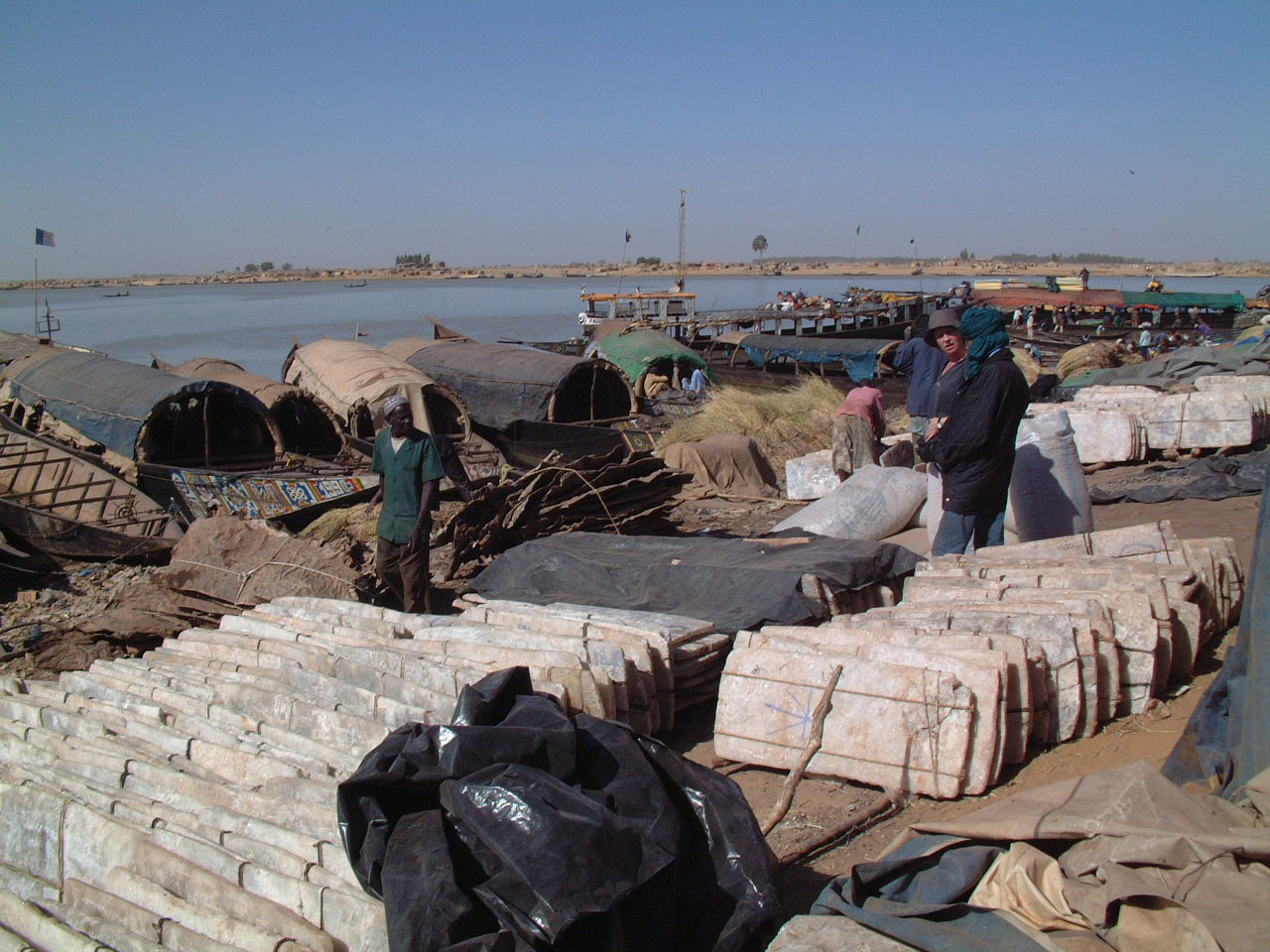
Taoudenni (also Taoudeni, Taoudénit, Taudeni, Berber languages: Tawdenni, Arabic: تودني) is a remote salt mining center in the desert region of northern Mali, 664 km (413 mi) north of Timbuktu. It is the capital of Taoudénit Region.[1] The salt is dug by hand from the bed of an ancient salt lake, cut into slabs, and transported either by truck or by camel to Timbuktu. The camel caravans (azalai) from Taoudenni are some of the last that still operate in the Sahara Desert. In the late 1960s, during the regime of Moussa Traoré, a prison was built at the site and the inmates were forced to work in the mines. The prison was closed in 1988.

Salt mining

[edit]

The earliest mention of Taoudenni is by al-Sadi, in his Tarikh al-Sudan, who wrote that in 1586 when Moroccan forces attacked the salt mining center of Taghaza (150 km north west of Taoudenni) some of the miners moved to 'Tawdani'.[2] In 1906, the French soldier Édouard Cortier visited Taoudenni with a unit of the camel corps (méharistes) and published the first description of the mines.[3] At the time, the only building was the Ksar de Smida, which had a surrounding wall with a single small entrance on the western side. The ruins of the ksar are 600 m north of the prison building.[4]

The Taoudenni mines are located on the bed of an ancient salt lake. The miners use crude axes to dig pits, which usually measure 5 m by 5 m with a depth of 4 m. The miners first remove 1.5 m of red clay overburden, then several layers of poor quality salt before reaching three layers of high quality salt. The salt is cut into irregular slabs that are around 110 cm x 45 cm by 5 cm in thickness and weigh around 30 kg. Two of the high quality layers are of sufficient thickness to be split in half, so that 5 slabs can be produced from the three layers. Having removed the salt from the base area of the pit, the miners excavate horizontally to create galleries from which additional slabs can be obtained.[5]

As each pit is exhausted another is dug, so there are now thousands of pits spread over a wide area. Over the centuries salt has been extracted from three distinct areas of the depression, with each successive area located further to the south west. The three areas can be seen clearly on satellite photographs. At the time of Édouard Cortier's visit in 1906 the mining area was 3 km south of the ksar;[6] in the 1950s, the active mines were located in an area 5 km from the ksar,[7] while the current mines are at a distance of 9 km.[8]

In 2007-2008, there were around 350 teams of miners, with each team usually consisting of an experienced miner with 2 labourers, giving a total of around 1,000 men. The men live in primitive huts constructed from blocks of inferior quality salt and work at the mines from October to April, avoiding the hottest months of the year, when only about 10 of them remain.[9]

The slabs are transported across the desert via the oasis of Araouane to Timbuktu. In the past, they were always carried by camel, but recently some of the salt has been moved by four-wheel drive trucks.[10] By camel the journey to Timbuktu takes around three weeks, with each camel carrying either four or five slabs. The typical arrangement is that for each four slabs transported to Timbuktu, one is for the miners and the other three are payment for the camel owners.[11]

Up to the middle of the 20th century, the salt was transported in two large camel caravans (azalaï), one leaving Timbuktu in early November and a second leaving Timbuktu in late March, at the end of the season.[12] Horace Miner, an American anthropologist who spent seven months in the town, estimated that in 1939-40, the winter caravan consisted of more than 4,000 camels and that the total production amounted to 35,000 slabs of salt.[13] Jean Clauzel records that the number of slabs reaching Timbuktu increased from 10,515 in 1926 to 160,000 (4800 t) in 1957–1958.[14] However, in the early 1970s the production decreased, and at the end of the decade was between 50,000 and 70,000 slabs.[15]

Prison

[edit]

A military post and a prison were built at Taoudenni in 1969 during the regime of Moussa Traoré.[16] The prison was used to detain political prisoners until 1988, when it was closed.[17] Many of the prisoners were government officials who had been accused of plotting against the regime.[18] The prisoners worked in the salt mines and many of them died. To the east of the ruins of the prison building is a cemetery containing 140 individual graves, of which only a dozen have names. They include:[19]

  • Yoro Diakité, head of the first provisional government following the coup of 19 November 1968, who died in 1973.
  • Tiécoro Bagayoko, head of security services from 1968 to 1978, who died in August 1983.
  • Kissima Doukara, Minister of Defence 1968–1978.
  • Youssouf Balla Sylla, police chief of the 3rd Arrondissement of Bamako.
  • Jean Bolon Samaké, head of the Goundam Cercle in 1969, who died in 1973.

Climate

[edit]

Taoudenni is a remote site in the hottest region on the planet, located over a hundred and sixty kilometres from the nearest inhabited location of any size. The region is located in the middle of the Sahara Desert, in the southern part of the Tanezrouft (one of the harshest areas on the planet, known for extreme heat and aridity), and features an extreme version of the hot desert climate (Köppen climate classification BWh). The region features a torrid, hyper-arid climate with unbroken sunshine all year long. Averages high temperatures exceed 40 °C (104 °F) from April to September and reach an extreme peak of 47.9 °C (118.2 °F) in July, the highest value for such an elevation above sea level.[20] Winters are also very warm compared to the world average. High temperatures average close to 27 °C (80.6 °F) in the coolest month. The mean annual daily temperature is around 29 °C (84.2 °F) and the annual average high is 37.8 °C (100.0 °F), one of the highest in the world. The annual average rainfall is between 1 cm (0.39 in) and 2 cm (0.78 in) which mainly falls from July to September because of the Intertropical Convergence Zone's influence on its climate.[21] On average, Taoudenni sees 3,700 hours of bright sunshine annually, with 84% of daytime hours being sunny. The site is also located in one of the driest regions on the globe.[22]

Climate data for Taoudenni
Month Jan Feb Mar Apr May Jun Jul Aug Sep Oct Nov Dec Year
Mean daily maximum °C (°F) 26.2
(79.2)
30
(86)
32.5
(90.5)
39.8
(103.6)
42.6
(108.7)
46.7
(116.1)
47.9
(118.2)
46.6
(115.9)
44.1
(111.4)
38.6
(101.5)
31.6
(88.9)
26.4
(79.5)
37.8
(100.0)
Daily mean °C (°F) 18.1
(64.6)
21.1
(70.0)
24.4
(75.9)
29.8
(85.6)
33.1
(91.6)
37.2
(99.0)
38.8
(101.8)
37.8
(100.0)
35.9
(96.6)
30.4
(86.7)
23.9
(75.0)
18.6
(65.5)
28.2
(82.8)
Mean daily minimum °C (°F) 9.9
(49.8)
12.2
(54.0)
16.3
(61.3)
19.8
(67.6)
23.6
(74.5)
27.6
(81.7)
29.6
(85.3)
29
(84)
27.6
(81.7)
22.1
(71.8)
16.2
(61.2)
10.8
(51.4)
20.4
(68.7)
Average precipitation mm (inches) 0.5
(0.02)
0.1
(0.00)
0.0
(0.0)
0.2
(0.01)
0.2
(0.01)
0.4
(0.02)
3.0
(0.12)
8.5
(0.33)
5.4
(0.21)
1.6
(0.06)
0.5
(0.02)
0.4
(0.02)
20.8
(0.82)
Average precipitation days 0.0 0.0 0.0 0.0 0.0 0.0 0.9 1.8 0.6 0.0 0.0 0.0 3.3
Average relative humidity (%) 33.5 29.1 25.6 23.1 23.5 28.9 35.8 43.0 40.4 31.4 32.3 34.2 31.7
Source: Weatherbase[23]

See also

[edit]

Notes

[edit]

References

[edit]

Further reading

[edit]
Revisions and contributorsEdit on WikipediaRead on Wikipedia
from Grokipedia
Taoudenni is a remote commune and salt-mining settlement in northern , centered on ancient mines that extract rock salt from the bed of a prehistoric in the Desert. The mines, operational for over seven centuries, involve manual excavation of pits up to 10 meters deep using basic tools to produce large slabs transported southward via caravans along historic trade routes, sustaining regional economies despite harsh conditions and minimal technological advancement. The Taoudenni area lies within the expansive Taoudeni Basin, a sedimentary formation spanning parts of , , and adjacent countries, rich in mineral resources including untapped hydrocarbons but primarily exploited for salt due to its surface accessibility and traditional methods documented since the .

Geography

Location and Physical Features

Taoudenni is positioned at coordinates approximately 22°40′N 3°59′W in northern , deep within the . This places it roughly 664 km north of , underscoring its remoteness from major population centers. The site functions as the administrative capital of Mali's Taoudénit Region, which was legislatively established in from portions of the former Timbuktu area. The terrain surrounding Taoudenni consists primarily of expansive flat salt pans, indicative of ancient evaporative deposits in the arid environment. These pans are encircled by shifting sand dunes typical of Saharan ergs, contributing to the area's physical uniformity and low relief, with elevations averaging around 295 meters above . The absence of permanent rivers, oases, or sources exacerbates the isolation, as the hyper-arid conditions preclude reliable surface water across the broader Taoudenni Basin. This combination of features renders the location one of the most inaccessible inhabited sites in the .

Taoudenni Basin

The Taoudenni Basin, also known as the Taoudeni Basin, is a vast intracratonic covering over 1.5 million square kilometers across , , and , forming the primary sedimentary cover of the West African Craton. This structure primarily records to deposition, with thick sequences of sandstones, shales, carbonates, and evaporites accumulated during prolonged from the late through the period. Limited strata, mainly in eastern portions, overlie the older successions in places where erosion did not remove them. The basin's geological history features initial clastic and carbonate sedimentation in the and El Mreïti Groups, transitioning to widespread marine deposits including organic-rich shales that serve as potential source rocks. formations, linked to restricted evaporative environments during the late —particularly Permian halite in basin-margin settings—underlie the extensive salt deposits exposed near Taoudenni, resulting from repeated marine incursions and in a maturing intracratonic setting. These evaporites not only influenced local stratigraphy but also acted as seals for potential subsurface traps. Beyond salt, the basin holds significant resource potential, particularly for hydrocarbons, with reservoirs and source rocks identified in its northeastern sectors. Exploration interest intensified in the , prompted by seismic surveys and drilling; the U.S. Geological Survey's 2016 assessment estimated mean undiscovered technically recoverable resources of 160 million barrels of and associated gas in the Mali-Mauritania portions. Despite limited commercial discoveries from wells drilled since the early 2000s, the basin's underexplored Infracambrian and plays, including stromatolitic carbonates in the Group, continue to attract attention for , gas, and emerging natural hydrogen prospects.

Climate

Environmental Conditions

Taoudenni lies within a hyper-arid environment, receiving an average annual of approximately 19 mm, with most months recording near-zero rainfall and only rare, brief events concentrated in late summer. This qualifies as hyper-arid by climatic classification, where annual totals below 25 mm preclude any significant or surface water persistence beyond ephemeral flashes. Temperatures feature pronounced seasonal and diurnal fluctuations driven by the region's low humidity, persistent clear skies, and lack of moderating moisture. The hot season spans May to , with average daily highs exceeding °C and peaking at 46°C in ; extreme daytime maxima have reached 48°C. In contrast, the cooler season from November to February sees average highs below 29°C, with January lows averaging 9°C, though nocturnal minima occasionally dip below 0°C during continental polar outbreaks. Diurnal ranges typically span 15–20°C, widening in the due to rapid at night. Prevailing winds, often from the east or north and averaging 15–16 km/h, intensify during to , fostering frequent dust storms that originate from the exposed salt pan surfaces. These events, triggered by strong surface gusts, erode fine sediments and salts, reducing visibility to near zero and depositing particles regionally, as observed in major Saharan outbreaks starting near Taoudenni. Such wind-driven processes exacerbate surface in the absence of stabilizing moisture or cover.

Impacts on Human Activity

The hyper-arid of Taoudenni, characterized by annual rainfall as low as 5 mm in the surrounding depression, severely constrains permanent , resulting in a sparse primarily composed of seasonal workers rather than year-round residents. This necessitates reliance on distant water sources, with nomadic pastoralists in northern engaging in long-distance migrations to access seasonal pastures and , limiting sustained habitation in the area. Such patterns reflect causal adaptations to , where fixed settlements would be unsustainable without external supply chains, as evidenced by the predominance of mobile herding systems over sedentary in the Sahara-Sahel transition zone. Extreme temperatures, often exceeding 45°C during daytime peaks and coupled with intense solar radiation, pose significant health risks including and stress for laborers and residents engaged in daily activities. In northern Mali's environments, these conditions exacerbate physiological strain, particularly during labor-intensive tasks, leading to elevated incidences of and cardiovascular complications without adequate hydration measures. Frequent dust storms further compound respiratory hazards through of fine particulates, which are linked to increased morbidity from pulmonary diseases in Saharan regions, as particulate matter penetrates deep into the lungs and triggers . The absence of viable vegetation cover and soil infertility, driven by negligible and high rates, precludes local or , forcing dependence on imported foodstuffs and goods transported via caravans or infrequent vehicular routes from southern . This logistical vulnerability underscores challenges, as disruptions in supply lines—often tied to seasonal mobility—can lead to food insecurity, compelling further migration or reliance on external aid for basic needs. Empirical observations confirm near-total barrenness in the Taoudenni Basin, where edaphic conditions inhibit growth and perpetuate economic isolation.

History

Pre-Colonial Salt Trade

Salt extraction at Taoudenni, situated in the northern Malian , formed a of trans-Saharan from the medieval period onward, with techniques involving the manual removal of overburden clay and excavation of layered rock salt slabs persisting largely unchanged since at least the . During the (c. 1240–1645 CE), which succeeded the in dominating sub-Saharan networks, Taoudenni's salt deposits enabled rulers to control vital exchanges, bartering salt northward for commodities like cloth and while facilitating southward flows of and slaves acquired via riverine routes along the . Tuareg nomads, leveraging their expertise in desert navigation, orchestrated the Azalai—a semi-annual caravan system linking Taoudenni to approximately 700 km south—where parties of hundreds of camels transported salt slabs, each cut to dimensions suitable for loads up to 90 kg, enduring grueling seasonal treks across arid expanses. This logistical feat, conducted primarily in the cooler months to mitigate heat and , sustained the Tuareg's economies by generating revenue from tolls, protection, and direct trade participation. Salt's intrinsic value as a preservative, source essential for health in tropical climates, and standardized —often equaling in ratios—drove these operations, with Taoudenni slabs reaching southern markets to preserve and , thereby underpinning population growth and imperial stability without reliance on perishable alternatives. The trade's stemmed from stark regional scarcities: abundant Saharan salt complemented -rich zones, fostering mutual dependency that propelled economic specialization and long-distance mobility over local subsistence.

Colonial and Post-Independence Developments

During the French colonial era in the early , the administration of Soudan Français incorporated Taoudenni into its control over Saharan resources, focusing on the exploitation of its salt mines to sustain trade in the Bend region. Previously dominated by Saharan groups who relied on slave labor for extraction, the mines underwent a French-imposed transition toward nominally free labor systems amid predictions of intensified colonial oversight as early as , though coercive practices and harsh conditions limited substantive changes. This exploitation prioritized exporting salt slabs via caravan routes to southern markets, bolstering colonial economic extraction without significant infrastructural investment in the remote site. Following Mali's independence from on September 22, 1960, Taoudenni fell under the central government's northern administrative framework, initially as part of Timbuktu Cercle in , where state efforts emphasized integrating desert peripheries into national resource management despite logistical challenges posed by vast distances and nomadic populations. The post-colonial regime maintained salt production for domestic trade but encountered persistent governance difficulties, including limited state presence that allowed traditional extraction methods to endure with minimal modernization. Administrative reforms accelerated in the 2010s, with the Taoudénit Region legislatively established in 2012 from northern territories to enhance local oversight, though full implementation, including official activation, occurred on January 19, 2016, amid broader initiatives. Concurrently, the longstanding caravan-based salt underwent partial shifts toward mechanization, as trucks supplanted convoys on declining traditional routes due to competition from cheaper industrial salt sources, reducing reliance on Taoudenni's output while preserving on a smaller scale.

Economy

Salt Mining Operations

Salt extraction at Taoudenni relies on manual underground mining techniques, where workers descend into shafts typically 15 feet deep to out large slabs of from deposits beneath a layer of . These slabs, often weighing 20 to 40 kilograms each, are hauled to the surface and cut into smaller blocks using basic tools like picks and saws, with minimal use of machinery due to the site's extreme remoteness and lack of . The labor force consists primarily of artisanal miners from Tuareg and nomadic groups, who endure six-month seasonal rotations in one of the world's most inhospitable environments, characterized by intense and isolation. These workers operate without modern safety equipment or mechanized support, relying on traditional methods that prioritize endurance over efficiency, as the deposits' shallow depth allows for hand extraction but demands physical resilience against dust, , and structural instability in the mines. Extracted salt blocks are loaded onto camels for transport via the historic Azalai caravan routes, primarily southward to , covering over 600 kilometers across the desert, though some modern operations supplement with trucks where feasible. This process sustains a reduced but persistent output, with caravans carrying slabs destined for further distribution, reflecting the persistence of pre-industrial logistics amid declining demand from industrial competitors.

Resource Exploration and Trade

Salt from Taoudenni continues to serve critical functions in , particularly for drying meat through and processes, and as a flavor enhancer, while also supporting health by preventing deficiencies in arid economies. These slabs, typically cut to dimensions of approximately 45x18x5 cm, are transported southward via traditional azalay operated by Tuareg traders, exchanging for grains like millet, , and other Sahelian in markets such as those in and . Despite the availability of trucks for bulk transport along certain routes since the mid-20th century, these —often comprising hundreds of camels covering 1,500 miles in 40-day treks—persist due to the rugged desert terrain inaccessible to vehicles and the caravans' role in supplementing herder incomes amid fuel costs and insecurity. The Taoudenni Basin exhibits potential, with geological assessments estimating undiscovered technically recoverable resources including mean volumes of conventional at 345 million barrels and gas at 2.37 trillion cubic feet across , , and adjacent areas. Exploratory efforts intensified in the 2010s, including drilling by Total on licenses like Ta8, partnered with (20% stake) and Qatar Petroleum International, though results yielded minor gas shows and disappointing outcomes that tempered further investment. Development remains stalled, with no commercial production due to ongoing jihadist insurgencies, political instability, and militarization in northern since the 2012 coup and subsequent conflicts, which have heightened risks for foreign operators. In Mali's mineral economy, dominated by comprising over 70% of exports, Taoudenni salt functions as a low-tech, artisanal commodity with annual production transported in 30-kg blocks by , sustaining local networks resilient to modern disruptions like shortages or . This trade, while marginal in national GDP terms (minerals at 6.3% overall), underscores salt's enduring value as a non-perishable staple in subsistence exchanges, contrasting with the high-risk, capital-intensive sector.

Economic Challenges

The remote location of Taoudenni in northern Mali's Desert creates profound infrastructural barriers, inflating production and transport costs while restricting for salt miners. Historically dependent on requiring extended journeys across arid terrain to reach southern hubs, the site's connectivity relies on limited, unpaved roads susceptible to sand accumulation and seasonal flooding, often rendering them impassable without specialized vehicles. These deficiencies exacerbate economic isolation, as reliable air access is minimal and road maintenance lags due to the government's prioritization of southern infrastructure. Competition from industrially produced salt has significantly undermined Taoudenni's traditional viability, as mechanized extraction and evaporation processes elsewhere yield lower-cost alternatives that bypass the labor-intensive slab-cutting methods still prevalent locally. Reports from the early highlight how such industrial outputs have "devastated" the market for Taoudenni's artisanal product, reducing for its higher-priced, slab-form salt transported via inefficient means. Southern Malian sources and imports further erode profitability, as closer, cheaper supplies diminish the premium once commanded by northern desert salt in regional exchanges. Recurrent droughts compound these issues by constraining water availability for operations and curtailing seasonal labor migration from nomadic herders, who supply much of the but face herd losses and mobility restrictions during prolonged dry spells. Severe droughts in 1972–1974 and 1983–1984, for instance, halted caravan movements and depleted local resources, foreshadowing ongoing vulnerabilities in an economy tied to unpredictable environmental conditions. Security disruptions from jihadist insurgencies in northern intensify these challenges, as armed groups control key routes, impose informal taxes, and deter investment, thereby reducing labor inflows and trade volumes.

Prison Camp

Establishment and Purpose

The Taoudenni prison camp was established in the late 1960s under the military regime of Moussa Traoré, who seized power in a coup against President Modibo Keïta on November 19, 1968. Construction of the facility began around 1969 as an open-air detention site integrated with the local operations, transforming the remote desert outpost into a site of forced labor. The camp's creation aligned with Traoré's authoritarian consolidation, targeting perceived internal threats amid Mali's post-independence instability. Its primary purpose was to detain and rehabilitate political opponents, including those accused of , , or opposition to the regime, functioning as a tool for suppressing through indefinite isolation and compulsory work. Prisoners, often high-profile figures such as officers and intellectuals, were sentenced to extracting salt slabs from underground mines, ostensibly to contribute to national resource production while deterring potential rivals via the threat of exile-like hardship. This dual role—punitive confinement and economic exploitation—reflected the regime's pragmatic use of state coercion to enforce loyalty and extract value from marginal territories. The site's selection in the desert, approximately 750 kilometers north of , leveraged its extreme remoteness for inherent security, with vast sand dunes and lack of infrastructure serving as natural barriers that minimized escape risks and oversight needs. By tying incarceration to —a historically vital but labor-intensive industry—the camp aimed to offset operational costs through prisoner output, which supported Mali's caravan economy while reinforcing the regime's narrative of productive reeducation. This approach echoed broader patterns in post-colonial African states, where peripheral resource sites were repurposed for political control without substantial investment in formal penal infrastructure.

Operations and Conditions

Inmates at the Taoudenni prison camp, established in 1969 during the regime of President Moussa Traoré, were compelled to perform manual labor extracting salt blocks from shallow desert pits measuring approximately 10 by 20 by 15 feet, using rudimentary tools for transport to regional . This forced labor operated without mechanized support, prioritizing punitive extraction over productivity or inmate welfare, in a facility functioning as an open-air detention site for political opponents until its closure around 1988–1991. Conditions were characterized by extreme Saharan heat and isolation, with minimal oversight that precluded external inspections, such as those attempted by the Red Cross in the , rendering the site effectively inaccessible. Prisoners received inadequate provisions, leading to rapid physical deterioration in an environment where survival depended on endurance against and exhaustion; condemnation to the camp was widely regarded as equivalent to a death sentence due to these unmitigated hardships. Escapes were virtually impossible given the surrounding vast expanse and lack of viable routes, ensuring containment without substantial guarding resources. The camp lacked any rehabilitative elements, serving solely as a mechanism for indefinite punitive isolation, with notable instances including the internment and subsequent death in 1983 of security official Tiécoro Bagayoko following his 1978 sentencing to hard labor there. No systematic records of mortality rates exist in available reports, but the structural design—combining grueling labor, nutritional deficits, and environmental extremes—resulted in high attrition among detainees, primarily political figures from the Traoré era's internal purges.

Closure and Legacy

The Taoudenni camp was shuttered in 1988, during the waning years of President Moussa Traoré's authoritarian rule, which had relied on such facilities to incarcerate political dissidents and enforce compliance since the camp's establishment in 1969. This closure preceded the broader wave in , triggered by nationwide protests that ousted Traoré in March 1991 and led to multiparty elections in 1992, though direct causal links between the camp's shutdown and these events remain unestablished in available records. The site was subsequently abandoned, leaving behind dilapidated structures integrated into the surrounding operations, with no significant infrastructure rehabilitation or repurposing undertaken by subsequent governments. In its aftermath, Taoudenni endures as a stark emblem of the coercive apparatus that sustained Mali's for over two decades, where forced labor in salt extraction demonstrably quelled potential unrest by instilling widespread deterrence among opponents, thereby bolstering regime stability until external pressures mounted. Empirical outcomes indicate that such remote penal facilities effectively isolated and neutralized threats without provoking immediate large-scale , contrasting with the moral critiques that later framed them as excesses of authoritarian control. No formal memorials or official acknowledgments have materialized, reflecting limited post-regime reckoning with the era's repressive tools, while the site's inaccessibility—exacerbated by ongoing Sahelian instability—restricts visitation to sporadic expeditions by adventurers navigating the hazardous terrain.

Demographics and Society

Population and Ethnicity

Taoudenni maintains a sparse permanent estimated at around 3,000 inhabitants, though precise data for the town remains limited due to its remote location and the challenges of enumerating nomadic groups. The broader Taoudénit Region, of which Taoudenni is the capital, recorded 18,160 residents in Mali's 2009 , reflecting low overall density in this Saharan expanse. figures are inherently fluid, as traditional pastoralist lifestyles lead to high mobility, with families and herders dispersing across the for and sources during dry seasons. The ethnic composition is dominated by Tuareg Berbers, a traditionally nomadic pastoralist group indigenous to the , alongside Arab Moors involved in networks. These groups constitute the core sedentary and semi-nomadic residents, with seasonal influxes of miners—primarily from similar ethnic backgrounds—swelling numbers during salt extraction periods from to March. Such patterns underscore a reliance on mobility over fixed settlement, complicating static demographic assessments and contributing to isolation-exacerbated challenges like sub-national average literacy rates below 20% in northern Mali's comparable areas and elevated vulnerability to desert-related health issues such as and limited access to .

Social Structure and Culture

Tuareg society in Taoudenni adheres to a traditional hierarchical structure characterized by endogamous castes, including nobles (imajaghan), vassals (imghad), religious specialists (ineslemen), artisans (inadan), and hereditary laborers (iklan), which historically dictate divisions of labor in activities such as salt extraction and camel herding. In the context of Taoudenni's salt mines, iklan castes have predominantly performed the physically demanding underground mining, while higher castes oversee trade and coordination, reflecting a feudal-like system adapted to resource scarcity in the . Tribal confederations further reinforce these affiliations, with loyalties influencing alliances for survival amid desert mobility and resource competition. Kinship among Taoudenni's Tuareg incorporates matrilineal elements, where descent and of key assets like tents and often trace through the female line, positioning women as custodians of family wealth and cultural transmission despite patriarchal household authority vested in men. This structure supports resilience in nomadic-pastoral economies, as women manage domestic resources during male absences for or expeditions, though overall decision-making remains male-dominated. Cultural practices emphasize oral traditions, including and genealogical recitations that preserve histories of routes and survival strategies against environmental hardships. , predominantly Sunni, permeates daily life with practices like and , yet syncretic integrations of pre-Islamic animist beliefs—such as reverence for spirits or ancestral rites—persist, blending with local to address ecological uncertainties. Adaptations for endurance include communal cooperatives among clans, pooling for seasonal migrations to oases, and collectives that distribute salt slabs via established caravan networks, enabling without centralized authority. These mechanisms, rooted in collaborations, facilitate risk-sharing in arid conditions where individual efforts would falter against or sandstorms.

Security and Recent Developments

Regional Conflicts

The 2012 Tuareg rebellion, initiated on January 17 by the secular National Movement for the Liberation of (MNLA), escalated into a broader as Malian forces collapsed amid a coup in on March 22. By April, (AQIM) affiliates, including and the Movement for Oneness and Jihad in (MUJAO), exploited the chaos to seize control of northern Mali's territory, imposing strict Islamic law and threatening remote areas like the Taoudenni Basin, where jihadist incursions disrupted local trade routes and mining operations. This phase resulted in the nominal declaration of independence by the MNLA on April 6, quickly undermined by Islamist dominance, with groups like AQIM establishing training camps and extortion networks across the , including zones proximate to Taoudenni. France's , launched January 11, 2013, with Malian and support, reversed jihadist advances by recapturing key northern towns by February, forcing insurgents into desert hideouts and reducing immediate threats to Taoudenni, though sporadic attacks persisted. This transitioned into in August 2014, a multinational effort involving 5,000 French troops focused on intelligence-driven strikes against AQIM remnants and emerging affiliates like the Islamic State in the Greater Sahara (ISGS), which by 2017 operated in the Taoudenni-adjacent borderlands with and . Barkhane's mandate emphasized preventing jihadist regrouping in ungoverned spaces, conducting over 20,000 patrols annually in northern until its drawdown began in 2021 amid political tensions with Mali's junta. Following Mali's August 2020 and May 2021 coups, the military government expelled French forces by August 2022 and allied with Russia's Wagner Group (later rebranded Africa Corps) from December 2021, deploying approximately 1,000-1,500 mercenaries to bolster the Malian Armed Forces (FAMa) against both jihadists and Tuareg separatists aligned with the Permanent Strategic Framework (CSP-PSD). Wagner operations in northern Mali, including the Taoudenni region, involved joint patrols and airstrikes targeting ISGS and JNIM (Jama'at Nasr al-Islam wal-Muslimin) cells, but also faced ambushes, such as the July 2024 Battle of Tinzaouaten near the Algerian border, where CSP rebels inflicted heavy losses on FAMa-Wagner convoys using Ukrainian-supplied drones, highlighting vulnerabilities in desert logistics. Jihadist groups maintain no permanent control over Taoudenni itself but conduct hit-and-run attacks on supply lines and sites, with ISGS claiming responsibility for and kidnappings in the basin as of , exacerbating access risks without establishing territorial dominance. Ongoing skirmishes between FAMa-Wagner units and CSP separatists, coupled with jihadist infiltration of nomadic communities, have intensified since the UN MINUSMA withdrawal in December 2023, displacing civilians and complicating state authority in the remote north, though Malian claims of territorial gains remain contested by independent reports of persistent insurgent mobility.

Infrastructure and Accessibility

Taoudenni's isolation in northern 's Desert constrains its infrastructure, with access limited to unpaved desert tracks extending roughly 700 km north from . These rudimentary routes are susceptible to sand erosion and seasonal flooding, complicating vehicular travel, while national road networks in feature only 13% paved coverage, with northern segments particularly underdeveloped and poorly maintained. Salt production, the town's economic mainstay, depends on traditional caravans and supplemental transport for exporting slabs to southern markets like , perpetuating low-volume, labor-intensive logistics amid minimal modernization. No rail lines or airports serve Taoudenni directly, precluding reliable air or high-capacity freight options. Utilities remain basic, with drawn from sparse wells amid arid conditions and generated via diesel, though rural broadly lacks grid connectivity, affecting 38% of households' access to improved as of recent assessments. Persistent security threats, including jihadist insurgencies and armed group activities in the as of 2025, impede upgrades and foreign investment, leaving the Taoudenni Basin's subsurface resource potential—encompassing hydrocarbons and emerging deposits—largely untapped despite exploratory interest.

References

Add your contribution
Related Hubs
User Avatar
No comments yet.