

Community hub
Recent from talks
Contribute something
Nothing was collected or created yet.
Torhout
View on WikipediaTorhout (Dutch pronunciation: [ˈtɔrɦʌut]; French: Thourout; West Flemish: Toeroet) is a city and municipality located in the Belgian province of West Flanders. The municipality comprises the city of Torhout proper, the villages of Wijnendale and Sint-Henricus, and the hamlet of De Driekoningen. On 29 February 2024 Torhout had a total population of 24,891. The total area is 45.23 km2 which gives a population density of 445 inhabitants per km2.
Key Information


People associated with Torhout
[edit]- Rimbert, saint
- Josse van Huerter, first settler, and captain-major of the island of Faial in the Portuguese Azores.
- Karel Van Wijnendaele (Founder of Tour of Flanders (Tour of Flanders))
- Benny Vansteelant (Multiple World Champion Duathlon) and Joerie Vansteelant
- Luk Descheemaeker, winner at the 2nd Holocaust cartoon contest in Tehran, 2016.
- Hilde Crevits, Vice Minister-President of the Flemish Government and Flemish minister of Economy, Innovation, Work, Social economy and Agriculture; and former mayor of Torhout (2016-2018)
- Brahim Attaeb, R&B singer and presenter
Festivities
[edit]Torhout-Werchter was until 1999 one of the largest annual pop festivals in Europe. Efforts were made to have a world music festival in Torhout after Torhout Werchter became Rock Werchter, held in Werchter only.
Sports
[edit]The main club of the city is Torhout 1992 KM.
Sights
[edit]-
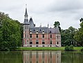 Aertrycke castle
 -
 Church: Sint Pietersbandenkerk
 -
 Watertower in Berg op Zoom
.jpg)


References
[edit]- ^ "Wettelijke Bevolking per gemeente op 1 januari 2018". Statbel. Retrieved 9 March 2019.
External links
[edit] Media related to Torhout at Wikimedia Commons
- Official website - Information available in Dutch and limited information available in French, English and German
| Bruges |  | |
|---|---|---|
| Diksmuide | ||
| Kortrijk | ||
| Ostend | ||
| Roeselare | ||
| Tielt | ||
| Veurne | ||
| Ypres | ||
| ||
| International | |
|---|---|
| National | |
| Geographic | |
| Other | |
This West Flanders location article is a stub. You can help Wikipedia by expanding it. |
Torhout
View on GrokipediaTorhout is a municipality and city in the province of West Flanders within the Flemish Region of Belgium, positioned in the arrondissement of Bruges at coordinates approximately 51°04′N 3°06′E.[1] It functions as the administrative center of the Houtland region, a wooded upland area characterized by its rural landscapes and historical significance.[2] As of 2025 estimates, Torhout has a population of 21,159 residents across a total area yielding a density of roughly 468 inhabitants per square kilometer.[3] The town features notable landmarks such as Wijnendale Castle, a medieval fortress, and the Sint-Pietersbandenkerk, a prominent church exemplifying local Gothic architecture, alongside a heritage tied to traditional industries like mustard production.[4][5]
Geography and Environment
Location and Administrative Boundaries
Torhout is situated in the province of West Flanders within the Flemish Region of Belgium, at geographical coordinates approximately 51°03′N 3°06′E.[6][7] The municipality forms part of the arrondissement of Bruges and encompasses a total area of 45.23 km².[8] Administratively, the municipality includes the central urban area of Torhout proper, along with the villages of Wijnendale and Sint-Henricus, and the smaller hamlet of De Driekoningen.[9] These sub-areas define the municipal boundaries, which border neighboring municipalities such as Lichtervelde to the south and Zedelgem to the north.[6] Torhout's location positions it about 19 km southeast of the city of Bruges and 23 km south of Ostend, facilitating connections via regional road and rail networks to these coastal and urban centers.[10][11]