

Community hub
Recent from talks
Contribute something
Nothing was collected or created yet.
Wagah
View on WikipediaWagah (/wɑːˈɡə/; Punjabi: واگھا [ʋäː˦ˈgä]; Urdu: واہگہ [ˈwɑːɦˌgɑː]), also spelled Wagha or Wahga, is a village and union council (UC 181) located in the Wahga Zone near Lahore City District, Pakistan.[1] The town is famous for the Wagah border ceremony and also serves as a goods transit terminal and a railway station between Pakistan and India.[2]
Key Information

.png)


Wagah is situated 600 metres (2,000 ft) west of the India-Pakistan border and lies on the historic Grand Trunk Road between Lahore and Amritsar in India. The border is located 24 kilometres (15 mi) from Lahore and 32 kilometres (20 mi) from Amritsar. It is also 3 kilometres (1.9 mi) from the bordering village of Attari in India. The Wagah flag-lowering ceremony – by the border security personnel of Pakistan (Pakistan Rangers) and India (Border Security Force) has been taking place here every evening since 1959.[3]
Border ceremony
[edit]
Border crossing
[edit]The border crossing draws its name from Wahga village, near which the Radcliffe Line, the boundary demarcation line dividing India and Pakistan upon the Partition of British India, was drawn.[4] At the time of the independence in 1947, migrants from India entered Pakistan through this border crossing and vice versa. The Wagah railway station is 400 metres (1,300 ft) to the south and 100 metres (330 ft) from the border.
Border crossing ceremony
[edit]The Wagah-Attari border ceremony happens at the border gate, two hours before sunset each day.[4] The flag ceremony is conducted by the Pakistan Rangers and Indian Border Security Force (BSF), similar to the retreat ceremonies at Ganda Singh Wala/Hussainiwala border crossing and Mahavir/Sadqi International Parade Ground border crossing. A marching ceremony, known as the "Silly Walk ceremony", is conducted each evening along with the flag ceremony. The ceremony started in 1986 as an agreement of peace, although there was not a conflict at that time.
Gallery
[edit]-
 122m high Pakistani flag on Wagah Border
 -
 Stadium-like seating at Pakistani side of the border
 -
 The Pakistani gate at the border crossing
 -
 Bab-e-Azadi (Gate of Independence) on Pakistani side of Wagah Border
 -
 Indian BSF at Wagah
 -
 Women personnel of Indian BSF at Wagah
 -
 Punjab Rangers at Waga


See also
[edit]References
[edit]- ^ "The Punjab Gazette" (PDF). Archived from the original (PDF) on 2018-06-12. Retrieved 2018-06-05.
- ^ "Mixed feelings on India-Pakistan border". BBC News. 14 August 2007.
- ^ Khaleeli, Homa (1 November 2010). "Goodbye to the ceremony of silly walks between India and Pakistan". The Guardian. Retrieved 11 November 2024.
- ^ a b Jacobs, Frank (3 July 2012). "Peacocks at Sunset". The New York Times.
External links
[edit]![]() Flag-lowering ceremony at Wagah border becomes more peaceful at Wikinews
Flag-lowering ceremony at Wagah border becomes more peaceful at Wikinews
- Michael Palin at the India-Pakistan border ceremony on the Pakistani side (from Himalaya with Michael Palin). BBCWorldwide video on YouTube.
- Sanjeev Bhaskar at the India-Pakistan border ceremony on the Indian side. BBCWorldwide video on YouTube.
- Pictures of independence's 60th anniversary celebration at Wagah Border
Wagah
View on GrokipediaGeography and Location
Site and Strategic Importance
, roads, barriers, and amphitheater-style seating for spectators, reflecting its dual role as a functional crossing and ceremonial venue.[12] Strategically, the Wagah-Attari crossing represents the only official overland route between India and Pakistan, enabling passenger transit and limited cargo movement despite periodic closures due to bilateral tensions.[9][2] It serves as India's sole operational land port for trade with Pakistan, handling goods like textiles, chemicals, and agricultural products, though volumes remain constrained by political disputes and infrastructure limitations.[9] Militarily, the heavily guarded site has historically functioned as a key defensive and logistical point, notably during the Indo-Pakistani wars of 1947, 1965, and 1971, when it supported troop deployments and supply lines along the Punjab frontier.[13] Its position amplifies Pakistan's potential as a regional trade hub in Central Asia, linking South Asian markets via overland corridors, though security concerns often overshadow economic opportunities.[14]Historical Background
Pre-Partition Context
Wagah, a small village in the Punjab province of undivided India, lay approximately 24 kilometers east of Lahore along the historic Grand Trunk Road, one of Asia's oldest trade and military routes dating back over 2,500 years and formalized in the 16th century under Mughal emperor Sher Shah Suri.[15][1] During the Sikh Empire (1799–1849), the village served as a jagir—a land grant—bestowed upon Sham Singh Attariwala (c. 1790–1846), a Jat Sikh general in Maharaja Ranjit Singh's army renowned for his command in campaigns against Afghan forces and his martyrdom at the Battle of Sobraon in 1846 during the First Anglo-Sikh War.[16][6] This grant underscored Wagah's proximity to Attari, Sham Singh's native village, and its position in the fertile Doab region between the Ravi and Sutlej rivers, supporting agriculture and local agrarian economies typical of Punjab's rural landscape. Following the British annexation of Punjab after the Second Anglo-Sikh War in 1849, Wagah remained a modest transit point within Lahore District, integrated into the colonial administrative framework that emphasized infrastructure for governance and commerce.[17] The village gained added connectivity with the expansion of the North Western State Railway in the mid-19th century, as the Lahore–Amritsar line, operational by the 1860s, included Wagah as a key intermediate station facilitating passenger and goods movement between major Punjab cities. This rail link, paralleling the Grand Trunk Road, enhanced Wagah's role in regional trade, particularly in grains, textiles, and livestock, though it hosted no major industrial or urban developments, retaining its character as a predominantly agrarian settlement with a mixed Hindu, Muslim, and Sikh populace reflective of Punjab's demographics prior to communal tensions escalation in the 1940s.[18] Strategically, Wagah's location at the crossroads of these enduring transport arteries made it vital for British military logistics, serving as a supply node during campaigns in the northwest frontier, yet it experienced no significant battles or administrative prominence beyond routine customs oversight on the undivided road and rail networks.[1] By the early 20th century, as pan-Indian nationalist movements grew, the village embodied Punjab's syncretic rural life, with local economies tied to Lahore's markets and Amritsar's commercial hubs, unmarred by the border divisions that would later define it.[17]Partition Events and Border Establishment
The partition of British India, enacted through the Indian Independence Act of July 18, 1947, divided the subcontinent into the Dominions of India and Pakistan effective August 15, 1947, with the Punjab province split based on religious demographics. The boundary in Punjab was determined by the Radcliffe Line, demarcated by Sir Cyril Radcliffe, chairman of the Punjab Boundary Commission, whose award was published on August 17, 1947. This line allocated Lahore and surrounding Muslim-majority areas to Pakistan while assigning Amritsar and Hindu/Sikh-majority districts to India, passing through fertile canal-irrigated lands and directly affecting villages like Wagah (assigned to Pakistan) and Attari (to India), approximately 25 kilometers from Lahore and 30 kilometers from Amritsar.[2][19] The Radcliffe demarcation, completed under tight deadlines with limited on-ground surveys, ignored some geographic and economic cohesions, such as rail links between Lahore and Amritsar, to prioritize communal ratios derived from the 1941 census, resulting in a jagged frontier that severed communities and infrastructure. In the Wagah-Attari sector, the line's placement near existing rail and road routes necessitated an immediate border post to manage cross-border movements, as the area became a funnel for evacuations amid rising communal clashes that began in March 1947 in Rawalpindi and spread province-wide.[2][19] On October 11, 1947, Indian Brigadier Lowell R.H. and Pakistani Brigadier Mohammad Ayub Khan met to establish a provisional Wagah check-post, initially demarcated by whitewashed stones and a single barbed-wire fence, serving as the primary land crossing for military convoys, refugees, and essential traffic. This setup addressed the logistical chaos of partition, where Punjab saw an influx of over 5 million Muslims into West Punjab from India and about 4.5 million Hindus and Sikhs into East Punjab from Pakistan, with Wagah-Attari overwhelmed by trains and caravans carrying displaced populations fleeing massacres that claimed between 200,000 and 2 million lives overall. The post's creation marked the formal operationalization of the border in this sector, transitioning from colonial internal lines to an international frontier enforced by respective armies.[17][2]Border Infrastructure and Operations
Crossing Facilities and Procedures
The Wagah-Attari border crossing operates exclusively for pedestrian travelers, with no provision for private vehicles across the international boundary; a mandatory shuttle bus transports passengers over the brief no-man's land separating the two gates. Facilities on the Pakistani side at Wagah include immigration counters staffed by the Federal Investigation Agency, customs inspection areas for baggage screening, and basic amenities such as restrooms, though reliable ATMs or currency exchange are unavailable at the border itself. On the Indian side at Attari, the Integrated Check Post features dedicated immigration halls, X-ray machines for luggage, and polio vaccination stations for incoming travelers lacking proof of immunization.[20] Crossing requires a valid passport with at least six months' validity and a physical visa stamp or approved e-visa printed in advance, as neither country offers visa-on-arrival at this land port for most nationalities; Indian e-tourist visas must initiate via air entry before land use, while Pakistani e-visas process online with approval letters mandatory. The border operates daily from 10:00 AM to 4:00 PM local time, closing promptly and prohibiting late arrivals even during the adjacent flag-lowering ceremony.[20][21] Procedures from India to Pakistan begin with arrival at Attari via taxi or bus from Amritsar (approximately 30-45 km, costing 1,000-1,200 INR), followed by initial passport verification, baggage X-ray, and polio vaccine documentation check—unvaccinated entrants receive an on-site dose. Travelers then board the shuttle bus to the zero line gate, disembark for final Indian exit stamps, and walk across to the Pakistani Bab-e-Azadi gate for entry questioning on travel purpose, itinerary, and accommodations, with full immigration processing typically taking 1-2 hours amid multiple security layers.[20] In the reverse direction from Pakistan to India, the process mirrors from Wagah: transport from Lahore (about 25 km, 800-1,200 PKR by rideshare), initial Pakistani exit checks including bag scans, shuttle bus to the gate, and handover to Indian authorities at Attari for visa scrutiny, purpose-of-visit interviews, and customs declarations prohibiting items like excess currency or contraband. Baggage rules limit carry-ons to small backpacks on the shuttle, with larger items secured in holds; conservative attire and patience are advised due to thorough interrogations focused on potential ties or intentions.[20][21] Special provisions exist for Sikh pilgrims holding Indian passports or Overseas Citizen of India cards, allowing visa-free access for religious visits such as to Kartarpur Sahib, though general foreign transit remains visa-dependent and subject to heightened scrutiny amid bilateral tensions.[20]Economic Role in Trade and Transit
The Wagah-Attari Integrated Check Post (ICP) functions as the sole operational land border crossing for official bilateral trade between India and Pakistan, handling the majority of direct cargo exchanges despite broader geopolitical constraints that route much commerce indirectly via third countries. In fiscal year 2023-24, the facility processed trade valued at ₹3,886.53 crore (approximately $470 million USD), encompassing 6,871 truck movements for exports and imports, primarily involving Indian pharmaceuticals, chemicals, engineering goods, and agricultural products destined for Pakistan, alongside Pakistani textiles, leather, and fruits entering India.[22][23] This volume constitutes a key segment of the official bilateral trade total, which declined to $1.2 billion in 2024 from $2.41 billion in 2018 amid heightened tensions and import bans.[24] Beyond direct India-Pakistan exchanges, the crossing supports regional transit, particularly for Afghan goods routed through Pakistan, with historical data showing combined India-Pakistan-Afghanistan trade via Wagah-Attari peaking at $830.58 million in 2019-20 before disruptions from border closures and security events reduced flows by up to 60% in Afghan exports to India by mid-2025. Passenger traffic, largely comprising traders, pilgrims, and visa holders, reached 71,563 crossings in 2023-24, bolstering ancillary economic activities such as logistics, warehousing, and cross-border services in Punjab's border districts.[25][26] Infrastructure at the ICP, inaugurated in 2012, includes dedicated cargo terminals, customs automation, and conveyor systems to minimize dwell times, though procedural delays—averaging 24-48 hours for truck clearances—persist due to bilateral visa restrictions and security protocols, elevating costs relative to maritime alternatives. These limitations underscore the route's underutilized potential, with studies estimating untapped bilateral trade capacity exceeding $10 billion annually if non-tariff barriers were eased, yet political sensitivities have repeatedly led to suspensions, as in April 2025 following a terror incident, halting all movements and amplifying reliance on costlier sea and air paths.[27][28][22]The Border Ceremony
Origins and Historical Development
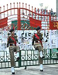
The Wagah-Attari border ceremony traces its roots to the immediate aftermath of the 1947 Partition of British India, which established the international boundary between the newly independent nations of India and Pakistan along the Radcliffe Line. The crossing at Wagah-Attari, located in Punjab, became one of the few land routes between the two countries, necessitating daily routines for border closure, including flag lowering, as a military tradition inherited from British colonial practices. This initial procedure was functional rather than ceremonial, focused on securing the frontier amid post-Partition violence and refugee movements that claimed over a million lives.[29] The formalized beating retreat ceremony, characterized by synchronized marches, high kicks, and competitive posturing between Indian Border Security Force (BSF) personnel and Pakistan Rangers, began in 1959. Initiated as a joint military exercise to close the border gates each evening, it evolved from a simple flag-lowering ritual into a display of national resolve and vigilance, reflecting the tense relations following the 1947 war over Kashmir. Both sides aimed to project strength and unity to their citizens, drawing crowds that grew over time and transforming the event into a public spectacle.[30][31] Early development emphasized patriotism in the nascent armies, separated from the British Indian Army, with the ritual serving as a tool to instill discipline and loyalty amid ongoing border skirmishes. By the 1960s, following the 1965 Indo-Pakistani War, the ceremony incorporated more theatrical elements, such as aggressive stares and foot-stomping, to symbolize unyielding defense of sovereignty without direct confrontation. Attendance surged, with stadium-like seating constructed on both sides to accommodate thousands, underscoring its role in fostering national identity during periods of diplomatic strain.[32][7]Daily Ritual and Key Elements
The daily ritual at the Wagah-Attari border, commonly known as the Beating Retreat ceremony, commences each evening approximately 30 minutes before sunset and lasts around 45 minutes.[33] This synchronized military drill is performed by contingents from India's Border Security Force (BSF) and Pakistan's Punjab Rangers, marking the formal closure of the border gate for the night.[12] The ceremony unfolds in the presence of large crowds seated in amphitheater-style galleries on both sides, who engage through cheers and nationalistic slogans such as "Pakistan Zindabad" or "Jai Hind."[10] The sequence begins with an inspection of the troops by their respective commanders, followed by the soldiers marching in formation toward the border gates with exaggerated, aggressive steps—including high knee lifts reaching up to chest height, thigh slaps, and thunderous foot stomps—to project strength and vigilance.[32] Personnel from opposing sides maintain intense eye contact and synchronized posturing, occasionally incorporating rifle drills and rapid advances to within inches of each other without physical contact.[34] Buglers play martial tunes, amplifying the theatrical display of discipline and rivalry. The ritual culminates in the simultaneous lowering of the Indian Tricolour and Pakistani Crescent flags, ensuring they descend at equal speeds and do not touch the ground, accompanied by the playing of each nation's anthem.[35] Commanding officers typically exchange salutes and a brief handshake before retreating, after which the iron gates are ceremonially shut.[36] This handshake has occasionally been omitted amid bilateral tensions, as observed in April 2025 following escalated hostilities in Kashmir.[37] The entire performance emphasizes precision, with movements rehearsed to maintain uniformity despite the adversarial tone.Military Participants and Symbolism
The military participants in the Wagah border ceremony consist of personnel from India's Border Security Force (BSF) on the Indian side and Pakistan Rangers on the Pakistani side.[29][38] BSF members wear khaki uniforms, while Pakistan Rangers don black attire, engaging in synchronized high-kick marches and stomping drills that emphasize physical discipline and vigor.[29] These forces, numbering around 6 to 10 soldiers per side during the core ritual, perform the beating retreat, culminating in the simultaneous lowering of national flags without allowing either to touch the ground.[38][39] The ceremony's symbolism underscores assertions of national sovereignty and military readiness between the two nuclear-armed neighbors, with exaggerated gestures like fist-shaking and stern glares projecting defiance and resolve.[29][40] It functions as a ritualized display of rivalry rooted in the 1947 Partition, reinforcing territorial claims and national identity for domestic audiences amid ongoing tensions over Kashmir and other disputes.[40][39] While some observers interpret elements of mutual respect in the coordinated flag procedure, the overall choreography prioritizes competitive posturing over reconciliation, serving as a controlled outlet for bilateral antagonism.[29][39]