
Community hub
Recent from talks
Contribute something
Nothing was collected or created yet.
Baubau
View on Wikipedia
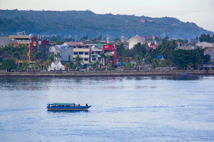
Baubau is a city in Southeast Sulawesi province, Indonesia. The city is located on the southwest coast of Buton island. Baubau attained city status on 21 June 2001 after Law Number 13 of 2001 was passed.[2] It covers an area of 294.98 square kilometres (113.89 sq mi), of which about 30 square kilometres (12 sq mi) is water. It had a population of 136,991 at the 2010 Census[3] and 159,248 at the 2020 Census;[4] the official estimate in mid-2023 was 161,280.[1] The city is the economic center of the Buton Island region and the second-largest city in the province. It was the cultural center of the Butonese people, the former capital of the Sultanate of Buton, the seat of the colonial administration of Eastern Sulawesi (Afdeeling Ost Celebes), and briefly the capital of the entire Southeast Sulawesi regency until 1955 when the capital status shifted to neighbouring Kendari.
Key Information


History
[edit]Etymology
[edit]There are several theories regarding the origin of the city's name. The first traces it to the word "bhaau", a Wolio language word meaning 'new', as the location was a bustling new town under the Sultanate of Buton. Another theory suggests that it came from "bau", a Malay word meaning "to smell", since it was a busy port town with unpleasant-smelling fish markets around the area.[5] A third suggestion descends the word from the Bugis noble title "Andi Bau", as many holders of this title settled in the city after fleeing the first and second Bone Wars.[6]
Early and colonial history
[edit]
According to local legends, the city's history started when four groups of Malay merchants in the late 13th century landed on Buton Island. Sipajonga and Simalui landed first on the southern coast and arrived with a banner that would become the banner of the sultanate. Sitamanjo and Sijawangkati followed, landing on the northern coast and eventually moving inland, establishing the area now known as Wolio Fortress, which became the center of governance. These four are collectively known as "mia patamiana"[clarification needed] and are said to be the origin of the royal family. The sultanate is said to have been a unification of four villages that later founded the kingdom.[5] Islam spread to the region after a visiting scholar from Johor in the 16th century converted the ruling royals and eventually turned the kingdom into a sultanate with its own constitution called "Murtabat Tujuh". During much of its existence, the political position of the Buton Sultanate was mainpulated by more powerful entities such as Makassar, Ternate, and the Dutch East India Company.[7] It was constantly under threat of invasion by the neighbouring Sultanate of Gowa and of raids by pirate ships from the Sultanate of Ternate, eventually falling under Dutch East India Company protection in the 17th century. A settlement later grew around Wolio Fortress and the palace complex that eventually become Baubau city.[5]
In 1911, under the Dutch colonial government, the city became the capital of Afdeeling Ost Celebes, and the governance of the whole eastern Sulawesi region was consolidated to the city.[5] As a result, the city grew in administrative importance and received modern infrastructure such as sealed roads, telephones, and military installments.[8] The development of the city's infrastructure was modeled after Sibolga and was tailored to help fight the spread of malaria due to the region's swampy nature.[9] This development was followed by economic expansion to the rest of Buton Island, starting with the opening of an asphalt mine in 1924. The asphalt was then used to construct inland roads to an economically important part of the island where there were coconut plantations and harvesting of forest goods such as rattan. During this time, the city also saw the founding of migrant quarters such as Kampung Bone and Kampung Wajo. Baubau acted as Southeast Sulawesi's main port, local goods hub, and main market town.[5][9]
Recent history
[edit]Baubau's economic importance declined following Indonesian independence, as the country's political power shifted from the sultanate to local figures and politicians. A local parliament was formed, with an election taking place in 1955, in which Masyumi and the Indonesian National Party gained the most seats (six and five respectively). The local parliament had already met in an ethnic Chinese school building in the city on 21 July 1953 and consisted of members appointed prior to the election.[9]
Between 1952's Law Number 34 and 1955, the city was the capital of the Southeast Sulawesi Regency (today corresponding to Southeast Sulawesi province). The regency was later divided into Buton Regency, Kendari Regency, Kolaka Regency, and Muna Regency, whose seats were Baubau, Kendari, Kolaka, and Raha, respectively.[5] When Southeast Sulawesi province formed, Kendari replaced Baubau as the capital, resulting in the latter becoming less relevant economically and politically.[9] Despite the creation of the province being the result of popular demand, the vision was initially that Baubau would become the capital; hence, the decision to choose Kendari was seen as betrayal of the original plan for the province. The decision to choose Kendari instead of Baubau was both the result of the city's losing a public vote against Kendari, 45–27, and of an incident where the city drafted two budgets produced by two different officials at the same time, creating dualism in the city's bureaucracy.[9] Both cities also experienced an influx of refugees in the 1950s due to the Darul Islam rebellion. People from outside of the cities were evacuated to camps within the city, with kidnappings of civilians by Darul Islam forces commonplace until the following decade.[9]
Baubau was granted city status in 2001 following the fall of Suharto and consequent decentralization across Indonesia, separating itself from Buton Regency.[10] Residents of Buton later demanded the creation of a new Buton Islands Province with Baubau as the capital, which would separate the regency from the rest of Southeast Sulawesi.[11][12] The creation of this province was supported by the governor of Southeast Sulawesi and the Regional Representative Council, but did not go ahead due to a moratorium on creating new autonomous regions under the presidency of Joko Widodo.[13][14][15]
Geography
[edit]Geographically, Baubau lies between latitude 5.21°S and 5.33°S and longitude 122.30°E and 122.47°E, and is located in the southern part of Southeast Sulawesi province. Baubau is bordered to the north by the Buton Strait (between Buton Island and Muna Island), to the east and south by the Buton Regency districts Kapontori and Pasarwajo, and to the west by South Buton Regency's Kadatua District.[16][17]
The topographical condition of Baubau consists mostly of mountains and hills above a long coast. Long hills stretch above the surrounding terrain with the variation of altitude between 0 and 100 meters above mean sea level. Baubau has a land slope of up to 40%. The dominant soil types in the city are cambisol, podzol, and latosol. Soils in the city and the rest of Buton Island are not fertile and are relatively unsuitable for large-scale farming. Similar to other Indonesian cities, Baubau has tropical weather. The day and night temperatures typically vary from 29 to 33 °C during the day and 20 to 29 °C at night.[18]
Governance
[edit]Administrative division
[edit]The city is divided into eight districts (kecamatan), tabulated below with their areas and their populations as of the 2010 Census[3] and the 2020 Census,[4] together with the official estimates as of mid-2022.[19] The city was previously divided into four districts: Betoambari, which had an area of 34.34 square kilometres (13.26 sq mi); Wolio, which had an area of 26.77 square kilometres (10.34 sq mi); Sorawolio, which had an area of82.25 square kilometres (31.76 sq mi); and Bungi, which had an area of 76.64 square kilometres (29.59 sq mi). At the time, Murhum, Kokalukuna, and Lea-Lea were incorporated within Betoambari, Wolio, and Bungi, while Batupoato was later spun out of Murhum.[19] The table includes the locations of the district administrative centres, the number of administrative villages (all classed as urban kelurahan) in each district, and their postcodes.
| Kode
Wilayah |
Name of
district (kecamatan) |
Area
in km2 |
Population
Census 2010 |
Population
Census 2020 |
Population
Estimate mid 2023 |
Administrative
centre |
Number
of villages |
Post
codes |
|---|---|---|---|---|---|---|---|---|
| 74.72.01 | Betoambari | 32.85 | 16,283 | 22,434 | 21,806 | Katobengke | 5 | 93721,
93724 & 93725 |
| 74.72.06 | Murhum | 6.13 | 19,261 | 20,021 | 20,860 | Lamangga | 5 | 93721,
93725 - 93727 |
| 74.72.08 | Batupoaro | 1.68 | 25,889 | 26,733 | 27,150 | Wameo | 6 | 93728 |
| 74.72.02 | Wolio | 33.89 | 37,974 | 43,342 | 43,484 | Wangkanapi | 7 | 93711–93715,
93717 |
| 74.72.05 | Kokalukuna[a] | 16.81 | 16,736 | 20,992 | 20,913 | Waruruma | 6 | 93711,
93716, 93719 |
| 74.72.03 | Sorawolio | 111.78 | 7,122 | 8,826 | 9,158 | Kaisabu Baru | 4 | 93731 |
| 74.72.04 | Bungi [b] | 58.89 | 7,096 | 8,381 | 8,791 | Liabuku | 5 | 93732 |
| 74.72.07 | Lea-Lea | 32.96 | 6,630 | 8,519 | 9,118 | Kantalai | 5 | 93733 |
| Totals | 294.98 | 136,991 | 159,248 | 161,280 | Betoambari | 43 |
Government and politics
[edit]As with all Indonesian cities, Baubau is a second-level administrative division run by a mayor and vice mayor together with the city parliament, and has a status equivalent to a regency.[20] Executive power lies with the mayor and vice mayor, while legislative duties are carried out by local parliaments. The mayor, vice mayor, and parliament members are democratically elected by the people of the city in elections.[21] The heads of districts are appointed directly by the mayor, with recommendations by the city secretary.[22][23]
The city is part of the 4th Southeast Sulawesi electoral district, together with Buton Regency, Wakatobi Regency, Central Buton Regency, and South Buton Regency, which together send 10 representatives to the 45-seat provincial parliament.[24] For city elections, the city is divided into three electoral districts with 25 seats.[25] The last election was in 2019 and the next one is planned for 2024. Below listed inside the table are the electoral districts in the city with their respective amount of seats.[24]
| Electoral district | Region | Representatives |
|---|---|---|
| Baubau 1st | Batupoaro, Betoambari, and Murhum | 11 |
| Baubau 2nd | Wolio | 7 |
| Baubau 3rd | Bungi, Kokalukuna, Lea-Lea, and Sorawolio | 7 |
| Total | 25 | |
Military
[edit]The city is the headquarters of Kodim 1413 / Buton, which oversees territorial defense of the entire Buton Island. It has been part of Korem 143 / Haluoleo under Kodam XIV / Hasanuddin since 2017, when the larger Kodam VII / Wirabuana was dissolved.[26]
Economy
[edit]Baubau's gross regional domestic product (GRDP) in 2023 was valued at 7.449 trillion rupiah. The largest contributors to the city's economy that year were its trade and retail, construction, and agriculture sectors, which consisted of 21.44%, 21.01%, and 15.60% of the city's GRDP. Its fastest-growing sector was its service sector, which grew by 11.05% between 2022 and 2023, and its fastest-declining sector was manufacturing, which declined by more than 22%. Economic growth of the overall city in 2023 was 3.38%, a decrease from the previous year's 5.28%.[27]
Agriculture and fisheries
[edit]The city's agriculture centers are Bungi, Sorawalio, and Lea-Lea districts, which between them have 59.6% of the city's registered agriculture business. In 2023, the city's most produced commodities were papaya and jackfruit, with the city producing 3,610 and 2,143 tonnes respectively, with high quantities of pineapple, tangerine, and dragonfruit also being produced.[27] Around 1,300 hectares of the city were allocated for rice fields,[28] however, many of these were underutilized and often abandoned by its farmers due to the soil being unsuitable for large-scale rice farming.[29][28][18] The city also has significant seaweed farming output, exporting 4,914 tonnes in 2022,[30] and fishing boats around the city catch decapterus fish, anchovies, mackerel tuna, and skipjack tuna. In addition, Baubau is a center of fish processing from nearby regions and processed around 10,000 tonnes of fish that were frozen and re-exported elsewhere in 2021.[30][31] The city planned to establish a shrimp aquaculture industry within the city in 2023.[32]
Tourism and service sector
[edit]The city's tourism and service sector contributed around 1.21% to the city's economy.[27] Baubau contains 50 registered hotels, 177 registered restaurant businesses, eight designated public market buildings, and 1,559 registered warungs. In 2023, the city was visited by 108,329 domestic tourists and 289 foreign tourists. The city has 3,458 registered small and micro industries in 2020, which employed 8,148 people that year.[33]
Other industries
[edit]There are 81 registered cooperatives in the city as of 2023, according to Statistics Indonesia.[27] There are several bank branches present in the city such as Bank Rakyat Indonesia, Bank Negara Indonesia, and Sultra Bank.[34][35][36] The city's main port, Murhum Port, aside from being used for fisheries, is also expected to support asphalt industries from nearby Buton Regency.[37] About 28,000 people from the city participated in economic activities related to or within small enterprises and microindustries that existed within the city in 2023.[38]
Demographics
[edit]
The most populous district in the city is Wolio district, which contained 27% of the city's population in 2023. This was followed by Batupoaro district with 17%, and Betoambari, Murhum, and Kokalukuna districts, with 13% each. The remaining 17% were distributed among other three districts (Lea-lea, Bungi, and Sorawolio). The average population growth of the city in 2023 was 1.18%, with Bungli district seeing 3.34% growth, Lea-Lea 3.20%, Betoambari 2.98%, Wolio 0.88%, Sorawolio 0.75%, Murhum 0.65%, Batupoaro 0.33%, and Kokalukuna 0.06%. The city's sex ratio was 98.45 males for every 100 females in 2023, with some districts such as Lea-Lea and Bungli having more males and other districts such as Wolio and Murhum having more females. The city's most densely populated district is Batupoaro with 16,161 people per square kilometre, followed by Murhum (3,403/km2), Wolio (1,283/km2), Kokalukuna (1,244/km2), Betoambari (644/km2), Lea-lea (277/km2), Bungi (149/km2), and Sorawolio (82/km2).[27]
Out of Baubau's total population of 161,280 in 2023, 84,185 were classified as economically active, with the city's unemployment rate that year being 2.17%, according to Statistics Indonesia.[27] The population pyramid of the city was dominated by those between age 14 to 34 years old in 2021. The religious demography of the city is dominated by Muslims with 96.65%, followed by Hindu as the second largest religion with 1.64%, Protestantism with 0.99%, Catholicism with 0.37%, and Buddhism with 0.05%, according to data from late 2021. The literacy rate in the city as of 2023 was 97.52%.[27] Baubau's national language is Indonesian, while its major regional language is Wolio, which was the official language of the Sultanate and is still taught in schools.[39][40] The city is also home to other regional languages of Buton, such as Cia-Cia which gained international attention when its users tried to use the Korean Hangul script to create a written version of their language.[41] Most of the city's inhabitants are Butonese, with a minority of Buginese, Moluccans, Javanese, and Sundanese migrants from other parts of Indonesia.[16]
Education
[edit]
The city has 110 kindergartens, 80 elementary schools, 38 junior high schools, 18 senior high schools, eight vocational high schools, and five tertiary education institutions registered in the city, according to Statistics Indonesia.[27] Universities in the city include Buton Muhammadiyah University, a private university run by Muhammadiyah, as well as Baubau Polytechnic and Dayanu Ikhsanuddin University. All universities and colleges in the city are private.[42][43][44]
Healthcare
[edit]The city has seven hospitals, three polyclinics, 26 puskesmas, and 23 registered pharmacies. Of the seven hospitals, four are general hospitals. Of the 26 puskesmas, five have inpatient care. One of the hospitals, Baubau City Regional General Hospital, is a public hospital managed by the city government and classified by the Ministry of Healthcare as C-class hospital. The rest of the hospitals are private, including one operated by Siloam Hospitals.[27][45]
Culture and entertainment
[edit]Butonese culture
[edit]
As the city was the capital of the Buton Sultanate, it retains many of the old sultanate's events and ethnic processions. A mix of Islamic influences and local cultures can be seen in celebrations such as Haroana Maludhu, which celebrates Mawlid, led by the sultan in the royal palace complex and attended by Butonese people. The procession lasts around a month and ends with an event celebrated inside the Buton royal mosque.[46] Another event, Haroana Rajabu, involves the Butonese people praying to their dead ancestors on the fourth Friday of the month of Rajab.[46] Aside from Islam-related events, many other events and processions take place, several of which are related to the sea. These include Tuturangina Andala, to ward off bad weather or disaster while seaborne, Harona Andala, to wish for success while fishing, and Phalantoana Bhangka, to inaugurate newly built ships made by local workshops.[46]
City parks
[edit]The city hosts several urban parks; one of the most prominent is Kotamara Park, which is located on the city's waterfront facing the sea. Built in 2010, the park was constructed on top of reclaimed land in Batupoaro district.[47] Hutan Pinus Samparona, an urban forest in Sorawolio district, is also a popular location with locals for hangouts and selfies. It is managed jointly by the city government and private investors.[48] Another park, Bukit Kaluku Park, was built in 2019 as part of a slum-upgrading project by the city. The park itself is located close to Kaluku Beach and has a direct view of Murhum Port.[49] There is also another park located close to a different beach within the city called Kamali Park.[50] A park located close to Wameo Market is used by vendors and hawkers in addition to its park function, while BRI Park near the city center was planned in 2022 to be a center for small businesses.[51][52] In 2012, the city has total of 1,192 hectares of land classified as city parks.[53]
.jpg)
Historical sites
[edit]The most prominent historical site in the city is Buton Palace Fortress, sometimes known as Wolio Fortress, which contains a royal complex. It was constructed around the 16th century, starting during the reign of Sultan La Sangaji and ending under Sultan La Buke.[54] In local folk legend, the fortress's construction was so time-consuming that subjects who took part were unable to work elsewhere, and the siolimbona, the sultanate's legislative body, threatened to impeach the sultan who insisted on continuing it. Due to the presence of this fortress and several others around the city, Baubau is nicknamed the "city of thousand fortresses".[55] These fortresses, including Wolio, were all built using carved coral reefs and limestone and were used as the main defense infrastructure of the sultanate.[55] Fortresses were so ubiquitous a part of the sultanate's infrastructure that the Wolio language word for "fortress" is synonymous with "city", and every single kadie (administrative division of Sultanate of Buton) had at least one fortress built on it.[55] The fortress itself and the complex inside of it were declared to be cultural heritage by Indonesia's Ministry of Education, who granted it legal protection. It is also the largest fortress in the Indonesian archipelago by land area, at 22.8 hectares, and has a circumference of 2,740 meters.[55] The fortress has a trench of around 1.5 kilometers in length which is divided into several parts for defensive purposes. Each part (baluara) of the fortress, is divided by internal walls and armed with cannons. It also has twelve gates (lawa) scattered around the fortress's outer layer. The inner part of the fortress is an old settlement complex said to have been founded by migrants from Johor and divided into limbo, each of which had administrative functions and a royal official. Inside this part is the royal mosque, built in 1712. The fortress also contains a 21-meter wooden flagpole, traditionally called kasulana tombi, which was built that year and is thought by Indonesian historians to be the oldest flagpole in the world still standing.[55][56] In 1871, the flagpole was struck by lightning, resulting in parts of it being replaced. In 2020, due to its old age and to prevent further damage, the flagpole was reinforced by the city government with additional supports and a protective structure made of iron.[55]
Certain parts of the city, especially around Balai Kota Street, contain colonial-era buildings, with their design resembling Art Deco style.[57] A former colonial resident office building, a former house of the Royal Netherlands East Indies Army officer, a colonial-era post office, and the town square (today called Merdeka Square) are located along this street. According to the Dutch administration, the spatial planning around this area with a central town square was a common feature of indigenous Muslim towns; the area was then reinforced for better surveillance and management of the natives' activities.[57] The Dutch also constructed a garden, called Keboen Raja, with a fountain at the intersection of Kartini Street and Sudirman Street. Today, only the fountain is left; the rest of the garden was converted into a landfill. Other colonial-era buildings included several palaces and residences constructed by the Dutch for the Buton sultans and royal family members. In addition to buildings built by the Dutch administration, the city also has a Chinatown area consisting of shophouses and old commercial buildings built by ethnic Chinese who immigrated during the 19th and 20th centuries.[57]
The area's more recent historical buildings, dating back to the early independence era in 1950s, include a housing complex for new civil servants dating to 1952. Baubau also includes the Galangi Monument, a monument of a figure wearing galangi, Butonese traditional wear, with their hand pointing to the port.[57] In total, there are 51 historical objects dating back to this era noted; most are managed or protected by the city's Culture and Tourism Department, though others lack documentation.[57]
Others
[edit]Baubau has one stadium, called Betoambari Stadium, mainly for association football and large ceremonies.[58][59] In 2021, the stadium was renovated with FIFA-standard grass.[59] The city is home to Persibau Baubau, an Indonesian football club playing in Liga 3.[60] The city also has other sports venues such as GOR Badminton Baubau for badminton, and several futsal fields, basketball, and volleyball courts, such as those in Murhum district, and the Lowu-Lowu Public Swimming Pool.[61] The Islamic Center of Baubau is located in Wameo subdistrict in Murhum district and is often visited by religious tourists.[62]
Transportation
[edit]
The city has a total road length of 472.3 kilometers, most of which are roads managed by the city government. National roads in the city comprise 53.4 kilometers of this total, while provincial roads comprise 9.5 kilometers.[27] Around 316 kilometres of the road are paved with asphalt, while the rest are of varying quality, including gravel and soil, as of 2023.[27] The city's main roads connect to other major towns on the island such as Pasarwajo and Ereke.[63][64] Baubau also has a ring road under construction, which is expected to be finished by late 2024.[65] The city's public transportation, as in most Indonesian cities, relies mostly on angkots with routes regulated by the local government, complemented by ride-hailing services such as Gojek and auto rickshaws.[66][67] In recent years, the number of angkots have declined due to ride-hailing services putting some angkot owners out of business after outcompeting them.[68]
Being located on an island, water transport is an integral part of city's transportation system to other islands or mainland Sulawesi. This service is provided primarily by Pelni and Sea Toll Program.[69][70] There was a plan to connect Buton Island to Muna Island via a bridge from Baubau, however, this plan was put on hold indefinitely in 2023.[71] The city is served by Betoambari Airport with regular flights to Makassar, Wakatobi Regency, and Kendari.[72]
Notes
[edit]References
[edit]- ^ a b Baubau Municipality in Figures 2024 (Report). Vol. 15. Badan Pusat Statistik Kota Baubau. 28 February 2024. ISSN 2622-4461. Retrieved 7 July 2024.
- ^ "UU No. 13 Tahun 2001". Database Peraturan | JDIH BPK. Retrieved 7 July 2024.
- ^ a b Biro Pusat Statistik, Jakarta, 2011.
- ^ a b Badan Pusat Statistik, Jakarta, 2021.
- ^ a b c d e f Tahara, Tasrifin; Bahri, Syamsul (2018). "Wolio, Buton, Atau Baubau Sebagai Wacana Nama Kota Baubau (Identitas Dan Transformasi Nilai Budaya Kesultanan Buton)". Pangadereng: Jurnal Hasil Penelitian Ilmu Sosial dan Humaniora (in Indonesian). 4 (1): 55–65. doi:10.36869/pjhpish.v4i1.73. ISSN 2686-4355.
- ^ "Mengenal Baubau dan Wangi-Wangi, Daerah dengan Nama Unik di Indonesia Halaman all". KOMPAS.com (in Indonesian). 16 February 2022. Retrieved 27 April 2024.
- ^ Schutte, G. J. (1994). State and Trade in the Indonesian Archipelago. KITLV Press. pp. 17–57. ISBN 978-90-6718-083-2.
- ^ Malim, Dinna Dayana; Sumantri, Iwan; Supriadi; Tahara, Tasrifin (23 July 2019). "Inventory and Development Potential of Baubau City Cultural Heritage". Kainawa: Jurnal Pembangunan Dan Budaya. 1 (1): 1–15. doi:10.46891/kainawa.1.2019.1-15. ISSN 2715-6184.
- ^ a b c d e f Rabani, La Ode; Purwanto, Bambang; Margana, Sri (31 August 2020). "Politik dan Ekonomi di Dua Kota: Baubau dan Kendari pada tahun 1950an–1960an". Mozaik Humaniora. 20 (1): 39. doi:10.20473/mozaik.v20i1.15746. ISSN 2442-935X.
- ^ Tuwu, Darmin; Sos, S. (October 2017). "Implication of conflict of ownership regional assets in the expansion of Bau-Bau City in the territory of ex Buton sultanate" (PDF). Jurnal Sosiologi Reflektif. 12 (1).
- ^ Nugraha, Al Khoriah Etiek. "Harapan Pembentukan Kepulauan Buton usai Jokowi Dapat Gelar 'La Ode Muhammad'". detiksulsel (in Indonesian). Retrieved 12 May 2024.
- ^ Wataullah, Haerul Mulku (10 May 2020). "Kepulauan Buton, Masih Lamakah Kehadiranmu?" [Buton Islands, How Long Will Your Presence Be?] (in Malay).
- ^ Rudi. "Moratorium Dicabut, Provinsi Kepton Mekar". Publik Satu (in Indonesian). Retrieved 12 May 2024.
- ^ "Gubernur Sultra Ali Mazi Apresiasi Positif Ketua DPD RI La Nyalla Mendukung Pemekaran Provinsi Kepton Arsip". BAUBAUPOST.COM (in Indonesian). Retrieved 12 May 2024.
- ^ "Gubernur Sultra Dukung Pembentukan Provinsi Kepton". Bisnis.com (in Indonesian). 2 June 2017. Retrieved 12 May 2024 – via Newswire.
- ^ a b "Profil Perkembangan Kependudukan Kota Baubau Tahun 2021" [Population Development Profile of Baubau City in 2021] (PDF) (in Indonesian). Archived from the original (PDF) on 13 May 2024.
- ^ Baubau Municipality in Figures 2024 (Report). Vol. 15. Badan Pusat Statistik Kota Baubau. 28 February 2024. ISSN 2622-4461. Retrieved 7 July 2024.
- ^ a b Mujabuddawat, Muhammad Al (30 August 2016). "Kejayaan Kesultanan Buton Abad Ke-17 & 18 dalam Tinjauan Arkeologi Ekologi". Kapata Arkeologi. 11 (1): 21. doi:10.24832/kapata.v11i1.279. ISSN 2503-0876.
- ^ a b Badan Pusat Statistik, Jakarta, 2023, Kota Baubau Dalam Angka 2023 (Katalog-BPS 1102001.7472)
- ^ "Wayback Machine" (PDF). www.dpr.go.id. Archived from the original (PDF) on 16 April 2021. Retrieved 13 May 2024.
- ^ "Wayback Machine" (PDF). www.dpr.go.id. Archived from the original (PDF) on 26 February 2021. Retrieved 13 May 2024.
- ^ "PP No. 17 Tahun 2018 tentang Kecamatan [JDIH BPK RI]". peraturan.bpk.go.id. Retrieved 16 April 2021.
- ^ Government Law No. 19 1998
- ^ a b "Peraturan KPU Nomor 6 Tahun 2023 tentang Daerah Pemilihan dan Alokasi Kursi Anggota Dewan Perwakilan Rakyat, Dewan Perwakilan Rakyat Daerah Provinsi, dan Dewan Perwakilan Rakyat Daerah Kabupaten/Kota dalam Pemilihan Umum Tahun 2024" (PDF). KPU RI. 2023. Retrieved 10 February 2023.
- ^ "Keputusan KPU Nomor 291/PL.01.3-Kpt/06/KPU/IV/2018 tentang Penetapan Daerah Pemilihan dan Alokasi Kursi Anggota Dewan Perwakilan Rakyat Daerah Provinsi dan Dewan Perwakilan Rakyat Daerah Kabupaten/Kota di Wilayah Provinsi Sulawesi Tenggara dalam Pemilihan Umum Tahun 2019" (PDF). KPU RI. 4 April 2018. Retrieved 22 January 2021.
- ^ "Sejarah Korem 143/Halu Oleo". korem143.tni-ad.mil.id. Archived from the original on 18 October 2022. Retrieved 24 May 2024.
- ^ a b c d e f g h i j k "Kota Baubau Dalam Angka 2024". baubaukota.bps.go.id. Retrieved 26 April 2024.
- ^ a b Heeryl (5 February 2022). "Lahan Luas, Petani di Baubau Kurang". Kendari News (in Indonesian). Retrieved 13 May 2024.
- ^ Abiddin, La Ode Muh (7 September 2021). "Kecamatan Sorawolio Diproyeksikan Jadi Kawasan Penghasil Jagung di Kota Baubau". Surya Metro. Retrieved 13 May 2024.
- ^ a b "SKIPM Kota Baubau antarpulaukan 4.914 ton rumput laut selama 2022". Antara News Sultra. ANTARA News Agency. 8 April 2023. Retrieved 13 May 2024.
- ^ Rini (23 January 2020). "Potensi Ekspor Perikanan Baubau Tinggi, Izin Pelaku Usahanya masih Sedikit". SultraKini.com (in Indonesian). Retrieved 13 May 2024.
- ^ "Kota Baubau mengembangkan budi daya udang vaname". Antara News Sultra. ANTARA News Agency. 25 January 2023. Retrieved 13 May 2024.
- ^ "PROFIL INDUSTRI MIKRO KECIL KOTA BAUBAU 2020". baubaukota.bps.go.id. Retrieved 13 May 2024.
- ^ "Pemkot Baubau Kerja Sama Sewa ATM Bank Sultra". web.baubaukota.go.id. Retrieved 14 May 2024.
- ^ "BNI Baubau Berbagi 300 Paket Sembako kepada Warga Kepton" [BNI Baubau Distributes 300 Basic Food Packages to Kepton Residents] (in Indonesian). Retrieved 24 May 2024.
- ^ "BRI Cabang Baubau Sukses Gelar Panen Hadiah Simpedes" [BRI Baubau Branch Successfully Holds Simpedes Prize Harvest]. www.rri.co.id. Retrieved 24 May 2024.
- ^ Sahab, Fahmi. "Ketua DPD RI Dorong Pelabuhan Murhum Baubau Jadi Pendukung Perkembangan Aspal Buton". Mantra Sukabumi.
- ^ "Trend Positif Ekonomi Baubau Tumbuh Berkat Peran UMKM" [Positive Trends in Baubau's Economy Growing Thanks to the Role of MSMEs]. www.rri.co.id (in Indonesian).
- ^ Anceaux, Johannes Cornelis (1988). The Wolio Language. Leiden: Brill. doi:10.1163/9789004286320. ISBN 978-90-04-28632-0.
- ^ "Tahun 2018, Kurikulum Bahasa Wolio Diberlakukan". INILAHSULTRA.COM (in Indonesian). 29 October 2017. Retrieved 13 May 2024.
- ^ "Menjelajahi Buton, Pulau Penghasil Aspal di Tenggara Sulawesi - Semua Halaman - National Geographic". nationalgeographic.grid.id (in Indonesian). Retrieved 14 May 2024.
- ^ "PDDikti - Pangkalan Data Pendidikan Tinggi". pddikti.kemdikbud.go.id. Retrieved 26 April 2024.
- ^ "PDDikti - Pangkalan Data Pendidikan Tinggi". pddikti.kemdikbud.go.id. Retrieved 26 April 2024.
- ^ "PDDikti - Pangkalan Data Pendidikan Tinggi". pddikti.kemdikbud.go.id. Retrieved 26 April 2024.
- ^ "RS Online". sirs.kemkes.go.id. Retrieved 13 May 2024.
- ^ a b c Munafi, La Ode Abdul (15 August 2022). "RAGAM PRAKTIK UPACARA DALAM TRADISI MASYARAKAT BUTON". Jurnal Pendidikan Sejarah: 59–74. ISSN 2686-3774.
- ^ "Melepas Senja di Kotamara, Kawasan Paling Indah di Kota Baubau, Sulawesi Tenggara". Tribunnews.com (in Indonesian). 15 May 2024. Retrieved 16 May 2024.
- ^ "Hutan Pinus Samparona, Wisata Alam untuk Swafoto dan Bermain" (in Indonesian). 18 February 2018. Retrieved 16 May 2024.
- ^ Djohan, Deni (5 April 2020). "Ini Destinasi Wisata yang Wajib Juga Dikunjungi di Kota Baubau". telisik.id (in Indonesian). Retrieved 16 May 2024.
- ^ "Lurah Wale Ajak Mayarakat Rawat Taman Di Pantai Kamali". BAUBAUPOST.COM (in Indonesian). 7 May 2019. Retrieved 16 May 2024.
- ^ "Taman Belakang Pasar Wameo Bakal Ditempati Pedagang". BAUBAUPOST.COM (in Indonesian). 19 June 2018. Retrieved 16 May 2024.
- ^ "Taman BRI Di Pusat Kota Baubau Akan Di Manfaatkan Pelaku UMKM". BAUBAUPOST.COM (in Indonesian). 26 September 2022. Retrieved 16 May 2024.
- ^ "Rencana tata ruang wilayah kota Baubau" [Baubau city spatial plan] (PDF) (in Indonesian). Archived from the original (PDF) on 24 June 2022.
- ^ "Hikayat Benteng Wolio Sulawesi Tenggara, Benteng Terluas di Dunia". liputan6.com (in Indonesian). 6 November 2022. Retrieved 15 May 2024.
- ^ a b c d e f Abdul Munafi; Muhammad Nasrun Saafi (2021). Mengenal kawasan cagar budaya Benteng Wolio: benteng Keraton Kesultanan Buton (in Indonesian). Universitas Halu Oleo Press. ISBN 978-602-5835-52-0.
- ^ kulitinta (12 March 2021). "Tiang Bendera Tertua di Dunia di Kota Baubau Tetap Terjaga Keasliannya". Kasamea.com. Retrieved 15 May 2024.
- ^ a b c d e Syahadat, Ray March; Arifin, Nurhayati H. S.; Arifin, Hadi Susilo (2015). "Lanskap Kolonial Kota Baubau Sebuah Pusaka Peninggalan Masa Kolonial di Sulawesi Tenggara". Paramita: Historical Studies Journal (in Indonesian). 25 (2): 185–195. doi:10.15294/paramita.v25i2.5130. ISSN 2407-5825.
- ^ "Upacara Haroana Baubau ke-482 Dipusatkan di Stadion Betoambari" [The 482nd Haroana Baubau Ceremony was centered at Betoambari Stadium]. Retrieved 24 May 2024.
- ^ a b Ma'waledha, Haludin. "Stadion Betoambari Baubau akan Pakai Rumput Standar FIFA - Hallo Sulsel". Stadion Betoambari Baubau akan Pakai Rumput Standar FIFA - Hallo Sulsel (in Indonesian). Retrieved 16 May 2024.
- ^ Redaksi (23 April 2018). "PS Baubau Keluhkan Tak ada Tim Medis di Liga III Sultra". Kolaka Pos News (in Indonesian). Retrieved 16 May 2024.
- ^ redaksi (10 November 2022). "Ini Lokasi dan Cabang Olah Raga yang Dipertandingkan di Porprov XIV Sultra di Buton dan Baubau - Suarakendari.com" (in Indonesian). Retrieved 16 May 2024.
- ^ "Wisata Religi Islamic Center Baubau Sambil Menikmati Pemandangan Sunset di Sore Hari". Tribunnewssultra.com (in Indonesian). Retrieved 16 May 2024.
- ^ "Pengendara Hati-hati: Sejumlah Titik Jalan Poros Baubau-Pasarwajo Amblas". SultraKini.com (in Indonesian). 22 February 2022. Retrieved 13 May 2024.
- ^ "Masyarakat Keluhkan Material Pemeliharaan Jalan Poros Ereke - Baubau, Kadis PU Butur 'Cuek'". BAUBAUPOST.COM (in Indonesian). 14 December 2021. Retrieved 13 May 2024.
- ^ "Pemkot Baubau komitmen tuntaskan pembangunan jalan lingkar". Antara News Sultra. ANTARA News Agency. 7 October 2022. Retrieved 13 May 2024.
- ^ "Kini GO-JEK Hadir di 158 Kota dan Kabupaten Indonesia". www.gojek.com. Retrieved 13 May 2024.
- ^ "Inilah 55 Fakta Menarik Tentang Buton Yang Jarang Ketahui – Dinas Pariwisata Sulawesi Tenggara". Retrieved 13 May 2024.
- ^ "Di Baubau, jumlah angkutan kota menurun". Antara News Sultra. ANTARA News Agency. 30 November 2018. Retrieved 13 May 2024.
- ^ "Wali Kota Baubau sebut Pelni berperan dalam pertumbuhan perekonomian". Antara News (in Indonesian). 1 May 2023. Retrieved 13 May 2024.
- ^ "Baubau Masuk Jalur Tol Laut". Antara News Sultra. ANTARA News Agency. 26 February 2017. Retrieved 13 May 2024.
- ^ Karsila, Anggun (21 March 2023). "Proyek Pembangunan Jembatan Buton-Muna Ditunda". Sultrademo.co (in Indonesian). Retrieved 13 May 2024.
- ^ "Bandara Betoambari Dukung Subsidi Penerbangan Baubau - Kendari" [Betoambari Airport Supports Baubau - Kendari Flight Subsidies]. www.rri.co.id (in Indonesian). Retrieved 24 May 2024.
External links
[edit]Regencies and cities of Southeast Sulawesi | ||
|---|---|---|
Capital: Kendari | ||
| Regencies | ||
| Cities | ||
| 2,000,000 and above | |
|---|---|
| 1,000,000–1,999,999 | |
| 500,000–999,999 | |
| 300,000–499,999 | |
| 200,000–299,999 | |
Note: Bold indicates provincial capital | |
Baubau
View on GrokipediaHistory
Etymology
The name Baubau derives from the influx of Bugis nobles and traders from South Sulawesi who settled in the Buton region, many bearing the title Andi Bau or simply Bau, a honorific associated with nobility among the Bugis people. The accumulation of such individuals in the area led locals to refer to it as Baubau, literally meaning "many Bau" in reference to the prevalence of this title among the migrants.[6][7] Originally hyphenated as Bau-Bau in historical and administrative records, the spelling was standardized to the unhyphenated Baubau under Buton City Local Regulation Number 2 of 2010, reflecting modern orthographic conventions in Indonesian place names.[8] This etymology aligns with oral traditions preserved by Butonese communities, though it remains a folk explanation without direct attestation in pre-colonial Sultanate of Buton documents, which primarily reference the area as Wolio.[6]Pre-colonial and sultanate era
The origins of the Buton kingdom, centered in Wolio (the historical core of modern Baubau), trace back to the early 14th century, with the kingdom enduring from approximately 1327 to 1541 as a pre-Islamic polity.[9] Local traditions attribute its founding to migrations and unification under early rulers, establishing a stratified society with nobility (kaomu) and commoners (walaka) that emphasized maritime trade and defense in the eastern Indonesian archipelago.[10] Islam first reached Buton Island around 1412, when the ulama Sayid Jamaluddin was invited by Raja Mulae Sangia i-Gola, marking initial conversions among the elite though not yet transforming the polity into a sultanate.[10] The full transition occurred in the mid-16th century, as the kingdom evolved into the Sultanate of Buton around 1541, with the ruling king La Kilaponto converting to Islam and adopting the title Sultan Murhum Kaimuddin Khalifatul Khamis as the first sultan.[10] [11] This shift integrated Islamic governance, with the sultan styled as Khalifatul Khamis, and expanded influence through fortified settlements and naval power. During the sultanate's formative phase, Wolio developed heavy fortifications starting in the 16th century under sultans like La Sangaji and La Buke, encompassing extensive walls and structures that underscored the realm's military prowess as a maritime power controlling trade routes near Southeast Sulawesi.[10] [12] The sultanate maintained a diarchic system blending royal and noble lineages, fostering a resilient political structure that persisted through internal hierarchies and external alliances until early European contacts in the 17th century.[13] Early sultans promoted Arabic-Wolio script for administrative and religious texts, reflecting Islamization's cultural imprint while preserving local customs.[9]Colonial and independence period
The Sultanate of Buton, centered in what is now Baubau, maintained relative autonomy from European powers through the 17th to 19th centuries despite early contacts with the Dutch East India Company (VOC). In 1613, the fourth sultan, La Elangi, signed the first treaty with the VOC's Governor-General Pieter Both, establishing trade relations without ceding sovereignty.[14] This alliance helped Buton navigate regional conflicts, including threats from Gowa-Makassar, but the sultanate preserved its independence as the Dutch focused on direct control elsewhere in the archipelago. Dutch influence intensified in the early 20th century, culminating in the Asyikin–Brugman Treaty signed on 8 April 1906 aboard the ship de Ruyter between Sultan Muhammad Ali Asyikin and Dutch Resident G. Brugman. This agreement subordinated the sultanate to Dutch colonial authority, transitioning Buton to indirect rule while restructuring its territories into districts starting in 1913. Baubau emerged as a key administrative hub under the Dutch Afdeeling Oost-Celebes, facilitating governance over eastern Sulawesi, though local Islamic traditions and sultanate structures persisted under colonial oversight. Following Indonesia's declaration of independence on 17 August 1945 and the formal transfer of sovereignty from the Dutch on 27 December 1949, the Buton Sultanate initially retained self-governing status as a swapraja domain within the new republic. However, centralizing reforms under President Sukarno led to its abolition in 1960, integrating Buton's territories fully into the Indonesian administrative system and ending the constitutional monarchy that had endured for centuries.[15] This marked the transition from colonial subordination to national incorporation, with Baubau evolving into a municipal center amid broader post-independence nation-building efforts.Post-independence development and city status
Following Indonesia's proclamation of independence on August 17, 1945, the Sultanate of Buton, centered in Baubau, formally aligned with the Republic of Indonesia; the 38th Sultan, Muhammad Falihi, pledged allegiance and facilitated the integration of Butonese territories into the new nation-state.[16] In the immediate postwar years, Baubau retained its role as a regional hub for agriculture, maritime trade, and small-scale mining—particularly asphalt extraction—but faced developmental setbacks amid national political instability, including shifts from parliamentary democracy to Guided Democracy under Sukarno and subsequent centralized control, which diverted resources away from peripheral areas like Southeast Sulawesi.[17] [18] The New Order era under Suharto (1966–1998) brought modest infrastructure gains, such as improved road connectivity and basic public services, yet Baubau remained administratively subordinate within Buton Regency, limiting local fiscal autonomy and investment in sectors like fisheries and heritage preservation.[17] Post-Suharto reforms, including the 1999 decentralization laws (UU No. 22/1999 and subsequent revisions), empowered regional pemekaran—administrative splitting—to foster localized governance and economic tailoring to ethnic and geographic specifics. Baubau achieved independent kota (city) status on June 21, 2001, via Law No. 13/2001, detaching it from Buton Regency with an initial area of 295.07 km² and jurisdiction over urban core functions, enabling direct elections for mayors and councils starting in 2005.[19] This elevation spurred targeted development, including expansions at Betoambari Airport for enhanced connectivity and initiatives to leverage sultanate-era sites for tourism, though challenges persisted in asset management and equitable resource distribution amid rapid urbanization.[20] [21] By the 2010s, city-led policies emphasized natural resource economics, such as sustainable fisheries and agro-processing, contributing to population growth from approximately 137,000 in 2010 to over 167,000 by 2018, while integrating traditional Butonese leadership values into modern administration.[22][19]Geography
Location and physical features
Baubau is a coastal city located on the southwestern shore of Buton Island in Southeast Sulawesi province, Indonesia, positioned between latitudes 5°18′30″S and 5°32′18″S and longitudes 122°33′22″E and 122°46′12″E.[23] The city spans a land area of approximately 295 km², encompassing urban, hilly, and coastal zones.[19] The topography of Baubau features predominantly undulating hills and mountainous terrain, with land slopes ranging from 8% to 30% and elevations varying from sea level along the coast to about 100 meters in central areas, including the historic sultanate site at 104 meters above sea level.[24][25] Buton Island's broader landscape includes rugged limestone karst formations, coral-derived rock structures, and interior low mountains rising to over 1,000 meters, contributing to cave systems and stratified geological features near the city.[26][10] The Baubau River and coastal cliffs further define the local physical environment, influencing settlement patterns and historical fortifications.[27]Climate and environmental conditions
Baubau features a tropical monsoon climate (Köppen Am), marked by high year-round temperatures, elevated humidity, and pronounced wet and dry seasons driven by the interplay of equatorial trade winds and the monsoon cycle. Average annual temperatures hover between 23.5°C and 31.7°C, with daily highs typically reaching 30–32°C and lows around 24–25°C; the warmest month is November at 31.7°C, while September records the lowest averages near 22.2°C for minima.[28] Annual precipitation totals approximately 2,253 mm, concentrated in the wet season from November to April, when monthly rainfall can exceed 300–400 mm, fostering lush vegetation but also flooding risks. The dry season spans May to October, with reduced rainfall averaging under 100 mm per month and minimal cloudy days, supporting drier conditions influenced by Buton Island's karst limestone terrain, which limits soil moisture retention.[29] Relative humidity consistently ranges from 80–85%, creating persistently muggy conditions that exacerbate heat stress, with wind speeds averaging 2–4 knots and occasional stronger gusts during transitional periods.[25] Sunshine hours vary seasonally, peaking at 8–9 hours daily in the dry period and dropping to 5–6 hours amid wet-season cloud cover. The climate supports tropical dry forests and coastal ecosystems, though urban expansion has introduced localized pressures such as detergent contamination in water bodies from household waste, elevating nutrient loads and risks to aquatic biota.[30] Environmental conditions reflect Baubau's island geography, with air quality generally compliant with national standards per governance assessments, though municipal waste generation—80–100 tons daily from households—strains disposal systems and contributes to potential leachate in karst aquifers.[31] [32] Water sources in many urban villages exhibit medium to high contamination risks from microbial and chemical pollutants, as mapped via geographic information systems, underscoring vulnerabilities in groundwater-dependent communities amid the region's porous limestone geology.[33] Climate variability, including erratic rainfall patterns linked to broader Indonesian monsoon shifts, poses adaptive challenges for food security and coastal erosion, with no severe aridification observed but increasing urban heat islands noted in performance metrics.[34]| Month | Avg. High (°C) | Avg. Low (°C) | Rainfall (mm) | Rainy Days |
|---|---|---|---|---|
| Jan | 31.0 | 24.5 | 350 | 15 |
| Feb | 31.2 | 24.6 | 320 | 17 |
| Mar | 31.5 | 24.8 | 280 | 14 |
| Apr | 31.8 | 25.0 | 200 | 12 |
| May | 32.0 | 25.2 | 120 | 8 |
| Jun | 32.2 | 24.8 | 80 | 6 |
| Jul | 32.0 | 24.5 | 60 | 5 |
| Aug | 31.8 | 24.2 | 50 | 4 |
| Sep | 31.5 | 23.5 | 70 | 5 |
| Oct | 31.2 | 24.0 | 150 | 9 |
| Nov | 31.7 | 24.5 | 250 | 12 |
| Dec | 31.3 | 24.7 | 320 | 14 |