Hubbry Logo
CalaguasCalaguasMain
Open search
Calaguas
Community hub
Calaguas
logo
8 pages, 0 posts
0 subscribers
Be the first to start a discussion here.
Calaguas
Calaguas
from Wikipedia

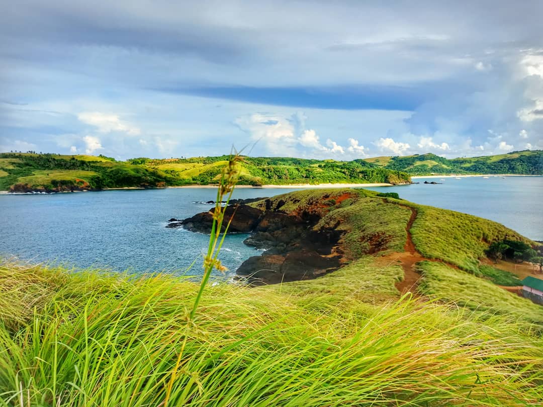
Calaguas, also known as Calaguas Islands, is a group of islands located in the Philippine province of Camarines Norte. It includes the major islands of Tinaga Island and Guintinua Island, the minor Maculabo Island, as well as several other minor. The group of islands is around 200 km away from the capital city of Manila and can be accessed through the ports at Paracale and Daet, Camarines Norte.[1]

Key Information

Most of the islands are under the administrative jurisdiction of Vinzons, while the minor island of Maculabo is under the jurisdiction of the municipality of Paracale. Recently, the island of Tinaga, where the well-known long beach called Mahabang Buhangin[2] is located, is experiencing an influx of tourists despite the absence of accommodation. Campers and backpackers visit Mahabang Buhangin to experience its powdery white sands.

The recent popularity of Calaguas Island has brought many tourists and travelers, especially during the summer. This has worried some of the natives and locals that increased tourism and the 2018 Boracay closure and redevelopment might lead to the detriment of the island's peace and serenity.[3] This is why the local government has created a program that will hold everyone responsible for taking care of Calaguas Island. Waste management and boat traffic are among the top concerns of the local government.[4]

References

[edit]
[edit]
Revisions and contributorsEdit on WikipediaRead on Wikipedia
from Grokipedia
![Calaguas Island in Camarines Norte][float-right] The Calaguas Islands form a remote archipelago of 17 islands and islets located off the northeastern coast of Luzon in the Philippine Sea, administratively belonging to the municipality of Vinzons in Camarines Norte province, Bicol Region. Primarily inhabited by small fishing communities, the islands support a sparse population of approximately 3,961 residents as of the 2020 census, concentrated in Barangay Banocboc on Tinaga Island, the largest and most developed islet. Renowned for their pristine natural features, including powdery white-sand beaches such as the 1.27-kilometer Mahabang Buhangin on Tinaga Island, crystal-clear turquoise waters conducive to snorkeling, and lush forested hills ideal for hiking and camping, the Calaguas have emerged as an ecotourism destination since the 2010s, with limited infrastructure helping to maintain ecological integrity amid growing visitor interest. Access remains challenging, typically involving 2- to 3-hour boat journeys from mainland ports like Vinzons or Paracale, which deters overcrowding and preserves the islands' appeal as a relatively unspoiled paradise compared to more commercialized Philippine beach destinations.

Geography

Location and Administrative Status

The Calaguas Islands are a remote group of islands located off the northeastern coast of in the , within the waters of the adjacent to province in the . Situated approximately 14-15 nautical miles northeast of the mainland town of , the archipelago includes major islands such as Tinaga and Guintinua, along with smaller islets like Maculabo. Administratively, the Calaguas Islands primarily fall under the jurisdiction of the in , encompassing barangays such as Mangcawayan on Tinaga Island, where the prominent Mahabang Buhangin beach is found. This municipal oversight governs most of the island group, supporting local governance and access from the Vinzons port. The minor island of Maculabo, however, is administered separately by the .

Physical Features and Geology

The Calaguas Islands comprise a group of 17 islands and islets off the northeastern coast of , with Tinaga Island as the largest landmass hosting the majority of physical features. The terrain of Tinaga Island features low hills covered in grasslands, steep coastal sections with rock outcrops, and long stretches of fine white sand beaches such as Mahabang Buhangin. Smaller islets exhibit exposed rock formations, minimal vegetation, and uninhabited hill grasslands. Geologically, the basement of the Calaguas Islands belongs to the Camarines Norte-Calaguas Islands complex, which incorporates an ophiolite sequence indicative of obducted oceanic lithosphere from . This pre-Late represents ancient and mantle material thrust onto continental margins during tectonic events shaping southeastern . Metamorphic rocks within the island group, as detailed in petrographic studies, further characterize the , reflecting deformation and alteration associated with regional orogenic processes. The overall structure aligns with the ' archipelago formation through emplacement, arc , and accretion since the .

Climate and Natural Hazards

The Calaguas Islands exhibit a typical of the , with consistently high temperatures averaging 24°C at night and 31–32°C during the day year-round, accompanied by high humidity levels often exceeding 80%. Rainfall is abundant throughout the year, totaling over 3,000 mm annually in nearby , the closest monitoring station, with the from June to November bringing peak precipitation—November alone averages 386 mm. The relatively drier period from December to May sees reduced but still significant monthly rainfall, ranging from 130–260 mm, supporting the islands' lush vegetation while minimizing extended dry spells. The primary natural hazards facing the Calaguas Islands are typhoons and associated strong winds, exacerbated by their exposed position in the Philippine typhoon belt, where approximately 20 tropical cyclones enter the country's area of responsibility each year, with several affecting the eastern seaboard. A vulnerability assessment identifies typhoons as the top hazard for Calaguas, followed by strong winds and drought, which can disrupt agriculture and tourism-dependent communities. In November 2024, Super Typhoon Pepito (international name Man-yi) directly threatened the islands, prompting PAGASA to raise Tropical Cyclone Wind Signal No. 5—the highest level, indicating catastrophic winds over 220 km/h—over Calaguas, leading to evacuations and halted sea travel. Storm surges and coastal flooding accompany these events, amplifying risks to low-lying areas and infrastructure. Seismic hazards exist due to the Philippines' location on the Pacific Ring of Fire, with the archipelago experiencing around 20 earthquakes daily nationwide, though Calaguas lacks major active faults or volcanoes directly beneath it, resulting in generally moderate shaking from distant events rather than localized high-magnitude quakes. Landslides are possible during heavy rains on the islands' hilly terrain, but documented incidents remain limited compared to typhoon impacts.

History

Pre-Colonial and Indigenous Settlement

Prior to the arrival of Spanish colonizers in the , the Calaguas Islands were inhabited by indigenous groups, including the Agta or Dumagat, who subsisted primarily through , , and gathering local resources such as and forest products. These semi-nomadic communities, skilled in navigating coastal waters, likely used the islands seasonally for exploitation of their rich fisheries, including and other pelagic species, while maintaining ties to mainland settlements in . The Agta of , also known locally as Manide or Abiyan Agta, represented one of the earliest populations in the , predating Austronesian expansions and characterized by dark skin, curly hair, and a deep dependence on the environment for . Archaeological evidence specific to the Calaguas Islands remains limited, reflecting the transient nature of these groups' occupations rather than permanent villages, though regional presence is corroborated by linguistic and genetic studies linking them to ancient Southeast Asian foragers. Mainland sites in areas like Labo and Santa Elena indicate similar adaptive strategies, with tools for and seafaring that would have extended to offshore islets like Calaguas. No records suggest large-scale pre-colonial trade or complex social structures unique to the islands, consistent with the small land area and isolation.

Colonial Era to Independence

The Calaguas Islands, falling under the jurisdiction of municipality in province, entered Spanish colonial governance as part of the Bicol region's incorporation following initial explorations in the 1570s. Spanish conquistador led an expedition in 1571 to in , drawn by abundant gold deposits, which marked the onset of systematic colonization efforts in the province, though direct engagements with the remote offshore Calaguas group remain unrecorded in primary accounts. Franciscan friars initiated evangelization drives in coastal locales, including Indan (the antecedent settlement to ) around 1581, establishing missions amid indigenous populations; the islands, however, likely sustained only transient use by Agta or Dumagat groups for fishing and resource gathering, with minimal permanent Spanish settlement due to their isolation. Provincial administration evolved through decrees affecting Camarines Norte: the unified territory of Ambos Camarines was divided into Norte and Sur provinces in 1829, briefly recombined in 1854, and separated anew in 1857, integrating peripheral areas like the Calaguas under alcaldía governance centered on mainland towns. Coastal vulnerabilities persisted, with Moro pirate raids plaguing Bicol harbors from 1573 into the 19th century, necessitating watchtowers and forts in places like and ; while Vinzons-area shores were exposed, no evidence details assaults or defenses specific to the Calaguas islets. The Spanish-American War culminated in the 1898 Treaty of Paris, ceding the to U.S. control, with American forces entering by March 1900 and Daet surrendering peacefully. Calaguas witnessed negligible or economic under American rule (1898–1946), preserving its marginal status amid broader provincial shifts like the 1919 reaffirmation of 's boundaries via U.S. Public Act No. 2809. arrived on , 1946, when the U.S. granted full sovereignty to the , formally concluding colonial oversight for the islands without notable local ceremonies or disruptions.

Post-Independence Development and Tourism Rise

Following Philippine in 1946, the Calaguas Islands experienced limited infrastructural and economic development, remaining isolated with local communities primarily engaged in subsistence fishing and agriculture. began to emerge in the late as the islands' pristine white-sand beaches, particularly Mahabang Buhangin on Tinaga Island, drew initial attention for their unspoiled natural beauty. The sector's significant rise occurred in the early , catalyzed by a 2013 nationwide online poll by Isla Lipana & Co., which named Calaguas the top " gem" among 175 destinations, enhancing its visibility and attracting global interest. This recognition led to approximately 10,000 visitors in 2013, marking a sharp increase from prior years. Visitor arrivals continued to grow, reaching 44,816 through port in 2016, though dipping to 34,897 in 2017 due to gale warnings. In response, basic infrastructure developed, including resorts such as Calaguas Paradise Resort with air-conditioned executive suites priced from P5,000 to P15,000 per night, and communal cabanas managed by units at P1,500 for groups of up to 10. Plans emerged for public parks, spas, restaurants operated by cooperatives, and a presidential proclamation designating areas for . By 2018, resorts reported a 50% increase in guests over the preceding two years, prompting concerns over environmental pressures like waste from tent camping and overcrowding, with local officials advocating sustainable regulations to avert Boracay-like degradation.

Ecology and Biodiversity

Flora and Vegetation

The Calaguas Islands, comprising small offshore landmasses in , feature vegetation dominated by tropical coastal scrub and hill grasslands, shaped by the islands' rugged and exposure to typhoons and strong winds. Larger islands such as Tinaga exhibit lush green hills rising behind white sand beaches, supporting adapted to saline coastal conditions and seasonal disturbances. Smaller islets often display sparse coverage, with some areas consisting of barren rock formations devoid of significant plant life, while others sustain grassland-dominated hills. Scientific documentation of specific flora remains limited, reflecting the islands' relative inaccessibility and focus on rather than botanical surveys; no comprehensive species inventories are available for the group. The broader region, including adjacent mainland areas, hosts dipterocarp-dominated lowland forests with seven species of Philippine mahogany ( spp.) and associated , suggesting potential for similar elements in undisturbed interior pockets of the larger Calaguas islands, though likely restricted by limitations from ophiolitic geology. Coastal zones may include resilient species like the pili (), an reaching 20 meters known for wind resistance and common in the . Hyperaccumulating plants tolerant of nickel-rich ultramafic soils, as found in the -Calaguas complex, could occur on geologically similar terrains, aiding but posing risks from mining proximity. Vegetation types align with Philippine island , emphasizing disturbance-adapted communities over primary due to historical clearing and climatic hazards like and cyclones, which exacerbate on steep slopes. Endemic Bicol flora, such as certain species, may extend to the islands, but confirmation requires targeted fieldwork amid ongoing gaps in the .

Fauna and Marine Life

The terrestrial fauna of the Calaguas Islands reflects the of small, remote Philippine ecosystems in , with observations limited by the area's relative inaccessibility and lack of comprehensive surveys. Reptiles such as monitor lizards (Varanus spp.), including like Enteng's monitor (Varanus dalubhasa), have been documented in nearby coastal and island habitats within the province, suggesting their presence on the Calaguas group due to similar ecological conditions. , including crabs (Tiomanium spp.) and centipedes (Scolopendra spinosissima), contribute to the ground-level diversity, while birds and small mammals likely include regional endemics adapted to forested and beach-edge environments, though province-wide records indicate over 300 bird in adjacent protected areas like Mount Labo without island-specific enumerations for Calaguas. Marine life around the Calaguas Islands thrives in fringing coral reefs, particularly in shallow waters, where benthic assemblages show high variability driven by hard corals, macroalgae, and sediments. Acropora species dominate coral cover in these shallow reef environments, supporting diverse fish assemblages typical of Philippine coral ecosystems, which collectively host over 2,000 reef fish species nationwide. Snorkeling sites reveal coral gardens teeming with colorful fish, invertebrates, and occasional larger species, underscoring the reefs' role as biodiversity hotspots despite limited targeted studies on Calaguas-specific endemism or threats. No critically endangered marine species are uniquely recorded here, but the reefs align with broader Philippine patterns of vulnerability to overfishing and sedimentation.

Conservation Initiatives and Protected Areas

The Calaguas Islands feature a local marine protected sanctuary aimed at preserving marine biodiversity, highlighted in provincial advocacy efforts as early as 2016. This sanctuary supports conservation of coral reefs and associated ecosystems amid growing tourism pressures. In response to concerns over uncontrolled development mirroring Boracay's environmental degradation, the municipal government of Vinzons in Camarines Norte pursued designation of the islands as an ecotourism area through a presidential proclamation in 2018. This initiative sought to enforce carrying capacity limits, regulate infrastructure, and prioritize low-impact tourism to maintain ecological integrity, though formal enactment remains pending. The Department of Environment and Natural Resources (DENR) has actively discouraged large-scale resort developments since at least 2014, citing risks to the islands' pristine ecosystems, and committed to establishing a monitoring station to safeguard natural resources and curb illegal occupations. Community-led practices, including beach clean-ups and tree-planting drives, complement these efforts, with organizations like TIES promoting responsible visitation to minimize waste and habitat disruption as of 2025. Despite these measures, the Calaguas group lacks inclusion in the national protected areas system under the National Integrated Protected Areas System Act, relying instead on local governance and voluntary compliance for enforcement. Ongoing challenges include balancing tourism growth with habitat preservation, as unregulated visitation has increased litter and erosion risks.

Human Geography and Society

Demographics and Local Communities

The Calaguas Islands, administered under the municipality of in , host a sparse primarily concentrated in coastal suited to and limited . According to the 2020 of and by the , Barangay Banocboc on Calaguas Island (also known as Calaguas Grande) recorded 3,961 residents, representing the largest settlement in the island group and comprising about 8% of Vinzons' total of 49,042. Smaller communities exist in Barangay Maculabo on the same island and Barangay Salvacion on Tinaga Island, though granular data for these specific locales remains aggregated within municipal totals, indicating populations likely under 1,000 each based on historical surveys and geographic isolation. The low density—estimated below 50 persons per square kilometer across the archipelago—stems from rugged terrain, seasonal storms, and historical underdevelopment, with net migration to mainland areas contributing to stagnant growth rates mirroring the Bicol Region's 0.87% annual increase from 2015 to 2020. Local communities consist mainly of extended fisherfolk families living in stilt houses along sheltered bays, sustaining themselves through artisanal capture of tuna, mackerel, and reef fish using outrigger boats and gill nets. Subsistence farming of coconuts and root crops supplements incomes, with copra production historically dominant before tourism's minor emergence. Social structures emphasize kinship ties and informal cooperatives for boat repairs and resource sharing, though access to potable water, electricity, and clinics is intermittent, reliant on periodic government resupply from Vinzons port. Education levels align with regional norms, with primary schooling available in barangay centers but secondary and higher education requiring mainland travel. Ethnically, residents are overwhelmingly of Austronesian descent, identifying as part of the broader Bikolano ethnolinguistic group prevalent in , where over 90% speak or Tagalog as primary languages per linguistic surveys. Pre-colonial inhabitants included populations such as the Dumagat or Agta, small-statured hunter-gatherers who navigated the archipelago's forests and coasts, but Spanish-era resettlement and intermarriage diluted distinct indigenous lineages, leaving minimal self-identified communities today—estimated under 5% regionally based on ethnographic mappings. Cultural practices blend Catholic rituals, including fiestas honoring patron saints, with animistic echoes in fishing taboos and boat-launching ceremonies, fostering resilient, self-reliant villages amid environmental pressures.

Cultural Practices and Indigenous Heritage

The Calaguas Islands were originally inhabited by indigenous groups such as the Agta or Dumagat, who practiced a nomadic lifestyle reliant on , gathering, , and small-scale farming from the surrounding and sea. These peoples, part of broader Aeta-related ethnolinguistic groups in , traditionally built clustered houses from local materials like , cogon grass, and leaves, emphasizing mobility and harmony with the environment. Their social customs included bahaginan, a communal partitioning and sharing of hunted game or gathered resources like wild pig or , which reinforced group survival and reciprocity. Dumagat communities persist in the Vinzons municipality encompassing the Calaguas Islands, with a focus on in areas like Pinagtigasan, where approximately 474 individuals benefit from cultural preservation efforts. Traditional practices among these groups involve ancestor veneration through spirits, accompanied by s featuring dances that mimic hunting movements and preserve oral histories via songs. Sacred sites such as rivers and mountains hold significance, while crafts like basket-weaving from kalagimay fibers are transmitted intergenerationally, often led by women in cooperative initiatives supported by the (NCIP). Contemporary cultural practices in Calaguas communities blend these indigenous elements with coastal adaptations, centered on traditions using banca boats for like , dolphinfish, and . Subsistence farming supplements marine resources, reflecting the Dumagat's historical self-reliance, though modernization and NCIP programs promote sustainable crafts like and production to enhance economic welfare without eroding heritage. Local expressions may include community events with music and honoring the sea's bounty, echoing broader Bicolano influences while rooted in indigenous resilience.

Economy

Traditional Economic Activities

The traditional economy of the Calaguas Islands, a remote group in , , has long revolved around subsistence fishing and coconut farming as primary livelihoods for local communities on islands like Tinaga and Maculabo. Residents, including descendants of indigenous Agta and Dumagat groups, have historically depended on for sustenance and , employing artisanal methods such as hook-and-line and small boat operations from coastal villages. Coconut cultivation dominates land-based activities, with families harvesting nuts for copra production—drying the meat for sale as a —which forms a staple income source amid limited and isolation from mainland markets. This practice traces back to Spanish colonial introductions of agriculture in the , supplementing earlier patterns but yielding modest outputs due to typhoon-prone conditions and rudimentary farming techniques. Small-scale farming of secondary crops like root vegetables occurs sporadically, yet it remains secondary to the sea and palms, reflecting the islands' coastal and pre-tourism self-sufficiency. Post-World War II, these activities sustained isolation until infrastructure improvements in the late , with fishing villages supporting populations of around 500 on Tinaga alone through daily catches sold locally or to mainland intermediaries.

Emergence of Tourism-Driven Economy

The emergence of in the Calaguas Islands accelerated in the late 2000s, driven by the allure of untouched white-sand beaches like Mahabang Buhangin, which gained visibility through early traveler accounts and . A pivotal boost occurred in when Calaguas topped a nationwide poll by Isla Lipana & Co. as the Philippines' premier "tourism gem," outranking 175 other destinations after voters selected it from a shortlist of 25 sites. This recognition, emphasizing its "concealed white beach of Bicol" status, heightened domestic awareness and visitor interest, marking a shift from obscurity to a sought-after nature-based destination. Prior to this growth, the islands' economy centered on subsistence fishing and limited , with residents relying on small-scale catches for . The influx of catalyzed a diversification, as locals pivoted to and support services, including boat transport, guiding, and renting basic cottages or homestays to capitalize on demand. Former fishermen, such as Cañeza, transitioned to resort-affiliated roles like boat operators, generating supplementary income from fares, tips, and onboard sales, thereby reducing dependence on volatile fisheries. By 2016, port records at Vinzons showed 44,816 arrivals, though numbers fell to 34,897 in 2017 amid gale warnings, illustrating tourism's weather sensitivity while affirming its scale. Individual resorts like Calaguas Paradise reported a 50% uptick in guests over the two years preceding , underscoring the sector's momentum in job creation and revenue for small operators. Industry observers, including Bicol tour operators, projected that sustained promotion would yield broader economic benefits, such as expanded local and opportunities, positioning tourism as the primary growth engine amid limited alternative industries.

Infrastructure and Recent Economic Projects

The Calaguas Islands feature rudimentary infrastructure, primarily consisting of unpaved or minimally improved local roads, limited port facilities for boat access from the mainland, and off-grid electricity reliant on solar panels and diesel generators. Access to the islands, particularly Tinaga Island, depends on a central in Mangcawayan, which serves as the main entry point for visitors and supplies. Water supply remains basic, drawn from local sources without extensive treatment systems, reflecting the islands' remote and underdeveloped status. Key road improvements include a 2020 Department of and Highways (DPWH) that converted a 485-meter gravel into a two-lane paved at a cost of PHP 14.7 million, enhancing local mobility and access to beach areas. Additionally, under the DPWH's Tourism Road Infrastructure Program (TRIP), the Pinagtigason to Mahabang Buhangin targets connectivity to white-sand beaches in Pinagtigason, Vinzons, to support without large-scale commercialization. Electricity infrastructure advanced with the Corporation's (NPC) 2018 inauguration of a power facility serving 697 households via hybrid systems, though supply remains intermittent, with mobile charging available at PHP 50 per session powered by solar and generators. In July 2025, officials announced plans for 24-hour power supply to the islands, aiming to bolster reliability for residents and emerging operations. Recent economic projects emphasize development amid environmental constraints. Tinaga Island Resorts Inc. initiated operations with regulated eco-resorts, including a September 2025 launch of a to fund expansions while adhering to setback requirements from beaches to preserve natural features. Local authorities have enforced pre-booking protocols for visitors and limited resort builds to prevent overcrowding, aligning with broader provincial efforts to integrate infrastructure like improved wharves without compromising the islands' pristine appeal. These initiatives, coupled with minor support such as seedling distributions in , seek to diversify income beyond while mitigating risks of overdevelopment.

Tourism

Access and Logistics

The primary route to the Calaguas Islands involves overland travel from to in , followed by local ground transport to a departure and a boat crossing. Buses operated by companies such as DLTB, Philtranco, Superlines, or Isarog depart from or Cubao terminals in , taking 8-10 hours to reach with fares around PHP 650-769 as of 2024. From , passengers take a (approximately 30-60 minutes, PHP 10-50) to ports such as Minaogan in , Vinzons fish , or Mercedes pier. Boats from these ports, typically local bangka ( canoes) hired in groups, cover the 1.5-2 hour crossing to key islands like Maculabo (home to Mahabang Buhangin ), with costs shared among passengers (around 1,000-2,500 per boat for 10-15 people, depending on size and conditions). Sea conditions can be rough, especially outside the ( to ), and many boats lack life jackets as they double as vessels; tourists are advised to travel in organized groups or via tour operators for safety and reliability. No scheduled ferries operate; all transfers are chartered, and advance booking through local ecotour agencies in (e.g., Calaguas Ecotours) is recommended during peak periods to secure spots and avoid weather delays. Alternative air access routes from involve flying to (WNP, about 1 hour flight), then bus or to or Mercedes (2-3 hours), extending total travel time to 7-9 hours but adding 2,000-4,000 in flight costs; direct flights to Airport exist but are infrequent and require similar boat . On-island remain basic, with no paved roads or ; visitors rely on walking, rented motorbikes ( 300-500/day), or guided transfers for inter-island hopping via additional boat charters ( 2,000-3,000 per group). Essential preparations include cash for fares (ATMs scarce), reef-safe , and confirmation of return boat schedules, as services halt during typhoons or high swells common in the (November-February).

Key Attractions and Activities

The Calaguas Islands, particularly Maculabo Island, feature Mahabang Buhangin Beach as the centerpiece attraction, a 1.2-kilometer expanse of powdery white sand fringed by clear turquoise waters and backed by lush hills. This beach draws visitors for its unspoiled natural beauty, often compared to more famous Philippine destinations like but with fewer crowds. Popular activities include and sunbathing in the calm, shallow waters, which remain relatively warm year-round, peaking at around 28–30°C during the from to May. along the shoreline reveals seashells and occasional , while stargazing at night enhances the serene ambiance. and allow exploration of nearby coral reefs teeming with , though equipment must typically be brought or rented locally due to limited facilities; dive sites near Apuao Grande feature vibrant marine . hopping by connects to smaller islets like Parola and Malagimsim, offering secluded coves for picnics and photography. Hiking trails on Maculabo ascend low hills for panoramic views of the , with paths varying from easy 30-minute walks to more strenuous routes suitable for moderate fitness levels. Camping on the , often in tents pitched directly on the sand, provides overnight stays with communal bonfires; permits from local authorities are required, and freshwater is sourced from community pumps. Cliff jumping from rocky outcrops into deeper waters appeals to thrill-seekers, though safety precautions are essential given variable .

Tourism Impacts and Management

Tourism in the Calaguas Islands has driven economic benefits for local communities but has also introduced environmental and social pressures, with visitor numbers rising from approximately 10,000 annually to over 15,000 following its recognition in an online poll by 2014. By 2016, arrivals reached 44,816, though they dipped to 34,897 in 2017 via port, amid concerns over overcrowding at key sites like Mahabang Buhangin beach. Peak periods, such as , have seen increased boat traffic posing safety risks to swimmers, with vessels occupying shorelines and prompting interventions to designate offshore docking areas. Environmental impacts include accumulation from visitors and pitching near beaches, which exacerbates challenges and threatens through risks of similar to those observed in overdeveloped sites like . Informal practices, such as dumping from boats, have been addressed through directives to operators, while broader fears of ecosystem degradation from creeping commercialization highlight vulnerabilities in the islands' pristine coral reefs and forests. Management strategies emphasize sustainable ecotourism to avert Boracay-like overdevelopment, with the Vinzons municipal government pursuing a presidential proclamation to designate the area as an ecotourism zone, enabling regulated facilities like a public park, spa, and cooperative-managed restaurant. The Department of Environment and Natural Resources (DENR) has actively discouraged permanent resort constructions, citing prohibitions on structures within 20-meter shoreline easements and forest reservations, and has established monitoring stations while reviewing land titles to curb illegal occupations detected via GPS. Local initiatives include regular coastal cleanups funded by private groups and the Jaycees chapter, alongside awareness campaigns on waste disposal, with proposals for a causeway in Barangay Mangcawayan and a provincial ordinance targeting congestion and sanitation. These measures prioritize preserving natural serenity over mass tourism, though enforcement remains challenged by rapid visitor growth.

Challenges and Controversies

Environmental Degradation Risks

The rapid growth in has intensified risks of accumulation and littering on the Calaguas Islands, where limited struggles to handle increased volumes; annual arrivals rose from around to over 15,000 by 2014, prompting concerns over unmanaged garbage that could degrade pristine beaches like Mahabang Buhangin. Boat operations during peak seasons, such as , further threaten environmental integrity by congesting shorelines, endangering swimmers, and discharging gasoline-laden wastewater that risks contaminating coastal waters with pollutants akin to those causing E. coli outbreaks in comparable Philippine destinations. By 2016, documented port entries reached 44,816 tourists, amplifying pressures from beachside tent camping, which heightens generation and exposes temporary structures to tidal erosion and storm surges without adequate or facilities. The absence of and formalized systems exacerbates these issues, potentially leading to and if visitor numbers continue unchecked, mirroring pathways to overload seen in over-touristed sites. The Department of Environment and Natural Resources has opposed expansive resort constructions since 2014, citing threats to the islands' exotic ecosystems, 20-meter shoreline easements, and vulnerability to illegal encroachments that could accelerate habitat loss and decline. hazards compound these anthropogenic risks, with typhoons, droughts, and strong winds identified as primary threats that could intensify erosion, , and vegetation damage in low-lying coastal areas. Unchecked development patterns risk replicating Boracay's trajectory, where unchecked led to severe degradation necessitating a closure for rehabilitation, underscoring the causal link between visitor influx and ecological tipping points in fragile island environments.

Development Debates and Policy Responses

The primary development debates surrounding the Calaguas Islands center on balancing tourism-driven economic growth with environmental preservation, given the archipelago's status as a pristine, low-impact destination. Local stakeholders and environmental advocates express concerns over "creeping development," including unauthorized resorts and infrastructure that could mirror Boracay's pre-2018 degradation from unchecked commercialization, which involved sewage pollution and coral reef damage leading to a six-month closure. Proponents of controlled development argue it could generate revenue for impoverished communities in Camarines Norte, where poverty incidence stood at 23.6% in 2021, through job creation in hospitality and transport, but critics, including the Department of Environment and Natural Resources (DENR), warn that large-scale resorts threaten the islands' exotic ecosystems, including endemic species and fragile white-sand beaches formed by specific coral and shell compositions. In response, the DENR's Bicol regional office issued a firm stance in 2014 against resort developments, emphasizing preservation of the islands' serenity and natural beauty over commercial exploitation, and committed to establishing a monitoring station to curb illegal occupation and resource extraction. The Vinzons municipal government pursued a presidential proclamation in 2018 to designate Calaguas as an ecotourism zone, aiming to enforce stricter zoning, waste management, and visitor caps to prevent overcapacity, as the islands' limited freshwater and infrastructure—such as reliance on boat access and basic sanitation—cannot support mass tourism without ecological collapse. Local policies include mandatory pre-booking for visitors and environmental user fees of PHP 20 per person collected by barangays, intended to fund conservation while discouraging unplanned influxes that peaked at thousands during peak seasons post-2013 recognition as a top Philippine tourism gem. Despite these measures, enforcement challenges persist, with reports of emerging resorts by 2023 indicating partial circumvention of restrictions, prompting calls for integrated assessments to align visitor numbers with ecological limits, such as beach erosion risks from and anchoring. Provincial initiatives under Camarines Norte's plans incorporate vulnerability assessments, identifying typhoons and droughts as key threats exacerbated by development, with policy recommendations for resilient like solar-powered facilities to minimize environmental footprints. Overall, responses prioritize "no-trace" principles and community-led management, reflecting a causal recognition that unregulated growth could irreversibly degrade the biodiversity-dependent appeal that sustains revenues estimated in the millions annually for local operators.

Social and Political Issues

The Calaguas Islands, primarily inhabited by small fishing and farming communities in Vinzons, Camarines Norte, face social challenges stemming from uneven distribution of tourism benefits. While visitor arrivals have surged, with concerns over unregulated growth mirroring Boracay's overdevelopment, local residents often receive limited economic gains, as resort operators have historically underinvested in workforce training and basic employee welfare. Basic infrastructure deficits persist, including inadequate health services and access to potable water, exacerbating vulnerabilities in remote island settings. Politically, the islands have encountered issues related to , including reports of fraudulent applications involving forged signatures of local officials, which undermine community control over resources. In response to development pressures, the municipal government has pursued presidential proclamations to designate parts of Calaguas as protected zones, aiming to balance growth with local governance and prevent external overreach. A notable political occurred in September 2024, when Vice President visited Calaguas amid national budget deliberations, prompting accusations from lawmakers that the trip constituted unauthorized leisure rather than official duties; Duterte countered that it involved direct engagement with residents on service gaps, while expressing satisfaction that the publicity could boost . This event highlighted broader tensions between national political figures and local priorities, though it underscored persistent community needs without resolving underlying governance debates.

References

Add your contribution
Related Hubs
User Avatar
No comments yet.