Hubbry Logo
CholseyCholseyMain
Open search
Cholsey
Community hub
Cholsey
logo
8 pages, 0 posts
0 subscribers
Be the first to start a discussion here.
Cholsey
Cholsey
from Wikipedia

Cholsey is a village and civil parish immediately south of Wallingford in South Oxfordshire. Its population in 2011 was 3,457.[2] 2011 Census. Its parish boundary, some 17 miles (27 km) long, reaches from the edge of Wallingford into the Berkshire Downs. The village green called "The Forty" has a substantial and ancient walnut tree.

Key Information

Winterbrook, historically the northern part of Cholsey, was absorbed into Wallingford in 2015. Winterbrook Bridge in the parish carries the Wallingford by-pass across the River Thames. The author Dame Agatha Christie, Lady Mallowan, lived at Winterbrook House until her death. John Masefield, poet laureate, lived at Lollingdon Farm in Cholsey from 1915 to 1917. Cholsey was transferred from Wallingford Rural District in Berkshire to the district of South Oxfordshire in 1974.

History

[edit]

A Bronze Age site has been found beside the River Thames at Whitecross Farm in the northeast of the parish.[3] A pre-Roman road, the Icknield Way, crosses the River Thames at Cholsey. A find announced in 2017 was of a substantial Roman site in Celsea Place.[4] Archaeologists discovered the best examples of corn dryers they have seen, with precision suggesting they were built by an engineer. Sites of burials and cremation pots have also been found. There is also part of a Roman villa, the majority of which appeared to have extended out under the existing road and houses and will have suffered significant unrecorded damage. The section of villa remaining within the archaeologically excavated area has been preserved in situ.

The village itself was founded on an island ("Ceol's Isle") in marshy ground close to the Thames. There is evidence that the House of Wessex royal family owned land in Cholsey in the sixth and seventh centuries. At this time the town was home to a Saint Wilgyth who was venerated locally in the Middle Ages. A royal nunnery, Cholsey Abbey, was founded in the village in 986 by Queen Dowager Ælfthryth on land given by her son, King Æthelred the Unready. The nunnery is thought to have been destroyed by invading Vikings in 1006 when they camped in Cholsey after setting nearby Wallingford ablaze.

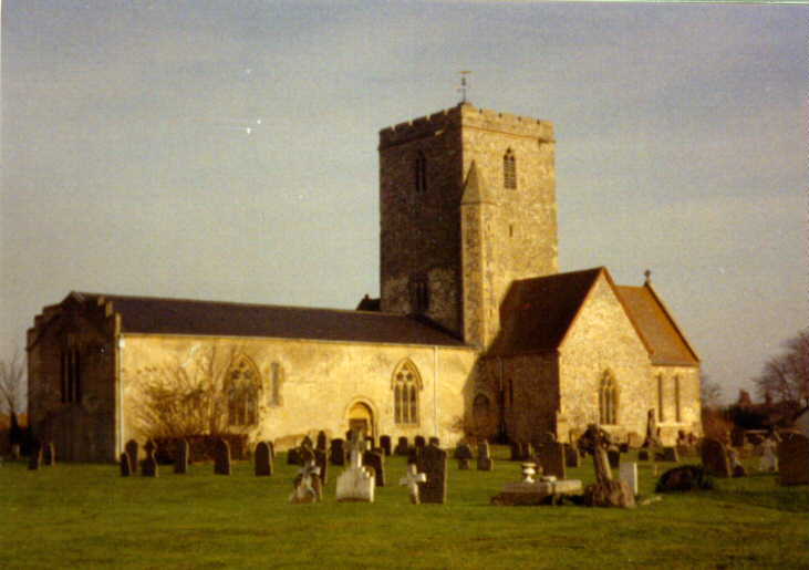
However, Saxon masonry still survives in the Church of England parish church of St Mary. Most of this flint and stone church was built in the twelfth century. The church is cruciform. Additions were made to it in the thirteenth and fourteenth centuries.[5] In the thirteenth-century a tithe barn was built in the village. It was, at the time, the largest aisled building in the world, being 51 feet (16 m) high, 54 feet (16 m) wide and over 300 feet (91 m) long.[6] It was demolished in 1815. Fair Mile Hospital, a former psychiatric hospital, opened near Cholsey in 1870 and closed in 2003.[7] In 2011–14 its Victorian buildings were converted to homes and new housing was built in its grounds.

Transport

[edit]
Cholsey railway station

Cholsey is served by Cholsey railway station, a calling point for Great Western Railway stopping services on the Great Western Main Line between Reading and Didcot. The station was also the junction for a branch line to Wallingford, nicknamed the "Wallingford Bunk", which the heritage Cholsey and Wallingford Railway now operates on bank holidays and some weekends. From Mondays to Saturdays Thames Travel bus route 136 links Cholsey with Wallingford and Benson. There is no evening, Sunday or bank holiday service.[8]

Architecture and buildings

[edit]

Writer and poet John Masefield lived in the parish for several years during World War I as tenant of Lollingdon Farm at the foot of the Berkshire Downs. He was Poet Laureate from 1936 to his death in 1967 and wrote a series of poems and sonnets called Lollingdon Downs. The farmhouse, on Westfield Road, has been listed grade II since 1986.[9]

The architect Edward Prioleau Warren (1856–1937), lived at Breach House, in Halfpenny Lane, Cholsey, built in 1906, which he designed for himself.[10] The building is grade II listed.[9]

St Mary's churchyard

[edit]
Gravestone of Agatha Christie and her husband Max Mallowan at St Mary's Church

The grave of novelist Dame Agatha Christie is in the churchyard of St Mary's. She lived with her second husband, archaeologist Sir Max Mallowan, at Winterbrook House, formerly in the north of the parish, from about 1934 and died there in 1976.[11] She and her husband had chosen a burial plot in the mid-1960s just under the perimeter wall of the churchyard. About twenty journalists and television reporters attended her funeral service, some having travelled from as far away as South America. Thirty wreaths adorned her grave including one from the cast of her long-running play The Mousetrap, and another sent "on behalf of the multitude of grateful readers" from the Ulverscroft Large Print Book Publishers.[12]

References

[edit]

Sources

[edit]
[edit]
Revisions and contributorsEdit on WikipediaRead on Wikipedia
from Grokipedia
Cholsey is a village and in , , located adjacent to the River Thames and immediately south of the town of Wallingford. As of the 2021 census, the parish had a population of 4,388 residents. The settlement originated as a Saxon island community in marshy terrain near the river, deriving its name from "Ceol's Isle," and it features notable historical landmarks including the partly Norman and the nearby Railway Viaduct designed by . The area's history traces back to the 6th and 7th centuries, when lands in Cholsey were held by the West Saxon royal family. In approximately , King founded a there—possibly the last major Anglo-Saxon monastic establishment in —as an act of penance for the murder of his half-brother, ; the lower portion of tower, incorporating distinctive "long and short" Saxon stonework, survives from this period. The abbey is recorded in the of 1086 and later became part of the extensive estates of , which held the manor until the Dissolution of the Monasteries in the . By the , the parish encompassed 4,447 acres and was integrated into the Great Western Railway network, with the Moulsford Viaduct (a skew structure of four elliptical brick arches crossing the Thames) completed in the 1830s to facilitate mainline travel. Cholsey gained modern prominence through its association with crime novelist , who resided at in the parish from 1934 until her death in 1976, writing many of her famous works there while maintaining a low-profile life as "Mrs. Mallowan." She and her husband, archaeologist , worshipped at and are buried in its churchyard. The village is also known for the Cholsey Great Barn, constructed around 1300 for to store agricultural produce from its fertile lands; at 303 feet long, 54 feet wide, and 51 feet high, it was likely the largest barn of its kind globally before its demolition in 1815, with recent digital reconstructions based on 18th-century surveys highlighting its architectural scale. Today, Cholsey functions as a commuter village with a focus on community services, including its parish council and railway station connecting to and .

Geography and Demographics

Location and Topography

Cholsey is a village and located approximately two miles (3 km) south of Wallingford in the district of , , positioned about 48 miles (77 km) west of . Its central grid reference is SU5886, placing it within the low-lying region. The covers an area of 8.92 km² (3.44 sq mi) following the 2015 boundary change that transferred the Winterbrook area to Wallingford, and is characterized by its terrain as a former island known as "Ceol's Isle" amid marshy ground in the . It borders the River Thames to the north, with the rising to the south, and lies between the North Wessex Downs (AONB) to the west and the Chilterns AONB to the east. This positioning creates a diverse landscape of floodplain meadows and gentle undulations, with elevations ranging from near along the river to around 250 feet (76 m) on the southern downs. Environmental features include a riverside prone to flooding due to its location, supporting habitats such as and wetlands. Archaeological evidence underscores the area's ancient significance, including a Late settlement and ritual site at Whitecross Farm in the northeast parish, featuring timber structures and middens on a Thames eyot. Administratively, Cholsey was transferred from to the newly formed county in 1974 under the Local Government Act 1972, shifting its boundaries to align with the modern county lines. In 2015, the Winterbrook area, historically the northern part of the parish adjacent to Wallingford, was absorbed into that town for local governance purposes, reducing Cholsey's extent and area from approximately 16.53 km² to 8.92 km² while maintaining its core rural identity.

Population and Housing

According to the 2011 Census, Cholsey had a of 3,457 residents (including the then-Winterbrook area). By the 2021 Census, this figure had risen to 4,388 for the reduced area, reflecting a growth of approximately 27% over the decade driven by new developments. Local projections anticipate further expansion, with the expected to grow by around 43% by 2035 to accommodate approximately 690 new homes as outlined in the 's housing strategy. The demographic profile of Cholsey features a mixed socio-economic grouping, with a balanced age distribution that supports a family-oriented . In 2011, the stood at 209 people per across the then 16.53 square kilometres (pre-boundary change); by 2021, with the reduced area of 8.92 square kilometres, the density was 492 per , an increase attributable both to and the boundary adjustment excluding the less densely populated area. Recent data indicate a stable structure, with significant proportions in working-age and family cohorts, alongside a growing older comprising about 20% over age 65. Housing in Cholsey totaled 1,359 dwellings as of the 2001 baseline, with 80% owner-occupied and 10% affordable social housing. In 2021, Bellway Homes launched Poppy Fields within the Yew Tree Gardens extension, adding a mix of two-, three-, and four-bedroom properties alongside bungalows and maisonettes. The Cholsey Neighbourhood Plan emphasizes affordable housing, mandating 40% of new units to be affordable, including shared ownership and social rent options to address local needs. Recent trends show an influx of residents to new estates, such as Way, a contemporary development constructed in 2018 offering terraced and homes with village views. However, affordability remains a challenge in this rural setting, where rising property prices outpace wage growth, prompting policies to prioritize local needs amid broader pressures.

History

Early and Medieval Periods

Archaeological evidence indicates early human activity in the Cholsey area during the , with a significant Late Bronze Age settlement uncovered at Whitecross Farm on a former eyot in the River Thames. Excavations revealed timber structures including jetties, palisades, and a possible , alongside occupation layers, a substantial , and evidence of , production, and crop , dated to approximately 1050–750 BC. The site, characterized by high-status artifacts such as , flint tools, and loomweights, suggests a small-scale, possibly seasonal riverside community in a of wooded scrub and grazed . Roman occupation is attested by the discovery of a site at Celsea Place in , during development-led excavations that identified stone-built corn driers, a well, a water hole, and a , pointing to agricultural and domestic activities from the Roman period. These features highlight Cholsey's role in the regional near the Thames, with the preserved as part of ongoing . The Anglo-Saxon origins of Cholsey trace to the 6th-7th centuries, with the settlement founded on an island in the marshy Thames floodplain, reflected in its name deriving from "Ceol's Isle," after Ceol, King of Wessex (r. 591–597), and linked to royal estates of the House of Wessex. Historical records suggest the Wessex royal family held land here, possibly including a palace, underscoring Cholsey's early ties to the emerging English monarchy. In the medieval period, Cholsey saw the foundation of an abbey in approximately 986 by King on land granted by his mother Ælfthryth; dedicated to , Æthelred's half-brother, it served as an act of penance following his 978 murder and marked the first religious house honoring the saint. The abbey may have been sacked by Viking raiders in 1006, who camped there one night after burning Wallingford, as recorded in the . Following this, the site transitioned to a parish community centered on St. Mary’s Church, which incorporates surviving Saxon masonry from the late 10th or early and was primarily rebuilt in the as a structure of flint and stone. Medieval Cholsey further developed under monastic influence, with constructing a 13th-century —the largest aisled building of its time at over 300 feet long, 54 feet wide, and 51 feet high—for storing agricultural s from local estates. Demolished in , the barn exemplified the village's integration into the feudal agrarian system. These institutions reinforced Cholsey's connections to early English royal and networks, evolving from a monastic foundation tied to legitimacy to a self-sustaining amid Viking disruptions and Norman transitions.

Modern Developments

The 19th century brought notable industrialization to Cholsey, primarily through infrastructure and institutional developments that fostered economic and demographic growth. The Great Western Railway's expansion facilitated the opening of Cholsey station in 1892, replacing the nearby Moulsford station and improving access to major cities like and , which encouraged commuter settlement and local commerce. Concurrently, Fair Mile Hospital opened in September 1870 as Berkshire's county , designed to house up to 285 patients in a self-sufficient complex with its own farm, laundry, and utilities, thereby creating jobs and stimulating village expansion. Throughout the 20th century, Cholsey experienced administrative and social transformations amid broader regional shifts. Under the Local Government Act 1972, the parish was transferred from to in 1974, realigning boundaries to better integrate it with adjacent areas like Wallingford and supporting coordinated planning efforts. Post-World War II contributed to steady , transforming Cholsey into a desirable commuter village with incremental additions that reflected national trends toward rural expansion near urban centers. The Fair Mile Hospital, renamed Berkshire Mental Hospital around 1915 and later integrated into the NHS, continued operating until its closure in March 2003 due to deinstitutionalization policies; the site was subsequently redeveloped into the residential community of Cholsey Meadows, with conversions of historic buildings into homes and new construction adding several hundred dwellings by 2014. In 2014, the area—historically part of Cholsey parish—was transferred to Wallingford parish to reflect its closer ties to the town, following a that considered local services and identity. This adjustment supported more efficient administration amid ongoing . From 2020 to 2025, Cholsey's modern evolution has emphasized community-led planning and balanced growth. The Cholsey Neighbourhood Plan, adopted in April 2019 after extensive consultations and a , sets policies for , environment, and infrastructure up to 2031; a initiated in 2022 to incorporate updates from the Local Plan 2035 reached post-examination stage by October 2025, with adoption anticipated soon and policies extended to 2035. Recent initiatives include the Homes development at Yew Tree Gardens (known as Poppy Fields), a residential estate where November 2025 proposals seek to formalize the existing 20mph speed limit across internal roads to prioritize pedestrian safety and livability. Community opposition has shaped contentious proposals, such as the 2021 application by Leavesley Developments for up to 350 homes, care facilities, and retail on land off Papist Way, which conflicted with Plan's allocation strategy and was refused by of State in October 2023 following a . Social impacts of these developments have prompted active resident engagement, including protests by over 200 locals in 2022, postcard campaigns to officials, and referendums integrated into Plan process, ensuring growth aligns with local needs for services, green spaces, and heritage preservation.

Governance and Community

Local Government

Cholsey is a within the District Council area, where the lowest tier of is provided by the elected Cholsey Parish Council. This council, comprising unpaid volunteer councillors, holds statutory responsibilities for enhancing community welfare and managing key local facilities, including the village's allotments, recreation ground, , and pavilion building. It also oversees certain bus shelters, defibrillators, dog poo bins, and footpaths to support public access and maintenance within parish boundaries. The parish's planning framework is guided by the Cholsey Neighbourhood Plan, which was originally adopted on 11 April 2019 and subsequently reviewed and made part of the on 13 October 2022, aligning with the Local Plan 2035. This plan covers the period from 1 April 2022 to 31 March 2035 and provides policies for accommodating approximately 690 new homes—exceeding the district's minimum requirement of 612 dwellings—while prioritizing the protection of heritage assets, such as listed buildings and conservation areas, and the surrounding landscape, including the Chilterns Area of Outstanding Natural Beauty. It integrates with district-level services by conforming to strategic policies on housing growth, , and biodiversity net gain, ensuring within defined built-up area boundaries. Community involvement in governance occurs through regular parish council elections, open public meetings, and resident consultations, such as the 2021 Zoom sessions addressing proposed developments like the Papist Way housing scheme. The council actively opposes unsustainable projects, as demonstrated by its successful stance against a 350-home proposal off Papist Way in 2023, which conflicted with neighbourhood plan allocations and was ultimately rejected by the Secretary of State. Key initiatives include ongoing management and enhancement of public spaces, with efforts to improve footpath accessibility, maintain green areas, and install or repair bus shelters in collaboration with . The council's 2024-2029 Strategic Plan and 2025 outline priorities such as increasing active travel routes and protecting , fostering integration with broader district services for cohesive community support.

Amenities and Education

Cholsey offers a range of recreational facilities maintained primarily by the Cholsey Parish Council, including the recreation ground off Station Road, which features play areas for children and a for older . Adjacent to this is the Cholsey Pavilion, a community hall with a 120-square-meter space, kitchen, and direct access to the recreation ground, used for , , and activities. The Forty, a set of playing fields in the village center, supports and other team sports, with an on-site overlooking the pitch. The parish also manages three allotment sites—Cholsey Meadows, Station Road, and Ilges Lane—providing residents with plots for gardening and community growing initiatives. A network of public footpaths crisscrosses the area, offering recreational walks through countryside and linking to nearby rural sites, while the council maintains public bus shelters and seating along key routes for resident convenience. Community amenities in Cholsey include essential daily services such as the on The Forty, which houses the village offering postal, banking, and government services. Additional shops, including a and barber, cater to local needs near the village common. The village supports social life through several traditional pubs, such as the Red Lion on Wallingford Road, a Brakspear-owned establishment with bars and a dining area, the Morning Star on Papist Way, which shares space with a , and the on Wallingford Road. Cholsey Meadows, a 100-acre development on the former Fair Mile Hospital site, provides public access to woodland trails and riverside paths along the Thames, blending natural parkland with residential areas for leisurely walks and . Education in Cholsey centers on Cholsey Primary School on Church Road, an serving children aged 5-11 in a vibrant focused on academic excellence and personal development, rated Good by in 2023. For secondary education, residents typically attend schools in nearby Wallingford, such as , which draws many pupils from Cholsey Primary as a partner feeder school; no higher education facilities exist within the village. Healthcare services for Cholsey residents are accessed primarily through GP practices in Wallingford, including Wallingford Medical Practice and Fairhill Medical Practice, both providing comprehensive NHS , appointments, and community health support. The former Fair Mile Hospital site, closed in 2003, has been redeveloped into housing without retaining medical facilities.

Economy and Employment

Local Businesses

Cholsey's local economy is characterized by a strong commuter orientation, with the majority of residents seeking employment beyond the parish boundaries in urban centers like , Reading, and . According to the 2011 Census, 74.7% of the 1,881 economically active residents aged 16 to 74 worked outside Cholsey, reflecting limited local job availability and a reliance on rail and road links for daily travel. Local employment opportunities are concentrated in retail and service sectors, including a Express supermarket with integrated Post Office services, the Best One , Rowlands , and independent outlets such as R.G. Park Family Butcher, Cholsey Cafe, and restaurants like Memories of and Shanki-Li. These businesses form the core of the village's commercial landscape at The Forty, providing essential daily needs and supporting a small number of part-time and full-time positions. Agriculture plays a notable role in the local economy, with arable and mixed farms operating in the surrounding rural areas, alongside ancillary services such as agricultural contracting firms like AEH Services and merchants including Frontier Agriculture Ltd. Small-scale enterprises, including builders, motor repair shops, dog kennels, and home-based operations, constitute the bulk of the approximately 100 businesses in Cholsey, many of which are family-run or sole trader ventures. The closure of Fair Mile Hospital in 2003, a former psychiatric facility that employed hundreds, has left a legacy of minimal industrial activity, with no significant manufacturing or large-scale operations present today. The socio-economic profile of Cholsey draws from a mixed demographic base, as indicated by the Census, where 43.3% of economically active residents were in full-time employment, 14.3% in part-time roles, and 12.2% self-employed, often in professional or skilled trades that facilitate to higher-wage areas. High skill levels among the workforce, including managerial and administrative , underscore the challenges of limited local opportunities, driving out-commuting and contributing to elevated rates of 36.9% for two-car households in . Recent , from 3,457 in to 4,388 in , has spurred demand for service sector expansion, with new housing developments enhancing viability for retail and home-based businesses. The Cholsey Neighbourhood Plan (adopted in 2019 and revised in 2022), prioritizes retaining village centre shops through policies like CNP I4 and I5, which advocate improvements in parking and delivery access to bolster commercial resilience amid housing-led economic shifts.

Tourism and Agriculture

Cholsey's landscape is predominantly agricultural, with arable farming forming the dominant land use across the Thames floodplain and surrounding areas, supported by the fertile clay soils of the Upper Thames Valley that enable cultivation of cereals and other crops. Traditional mixed farming practices, including some livestock rearing, persist on these lands, contributing to the rural character of the parish. The Cholsey Neighbourhood Plan (CNP) actively protects this agricultural heritage through policies such as CNP E1, which seeks to avoid the loss of best and most versatile agricultural land and requires soil surveys for any development proposals on farmland, thereby safeguarding against urban sprawl while promoting sustainable land management. Tourism in Cholsey centers on its rich literary and historical connections, drawing visitors to sites linked to notable figures and natural features. The village is a key stop on the Trail, which highlights her long residence at and her grave in the northwest corner of yard, where she worshipped for over 40 years until her death in 1976; this attracts global enthusiasts of her mystery novels. Literary heritage also includes associations with Poet Laureate , who lived at Lollingdon Farm and drew inspiration from the local downs for works like "Lollingdon Downs." Historical attractions encompass the remnants of Cholsey Abbey incorporated into , a 12th-century structure with surviving Anglo-Saxon tower elements from what may have been England's last major pre-Conquest monastery, as noted in the . Outdoor draws include riverside walks along the National Trail bordering the parish and explorations of Cholsey Marsh Nature Reserve, a with wet woodlands, damp meadows, and rare species like the Desmoulin's whorl snail, offering tranquil spots for and nature appreciation. The economic impact of supports local without overwhelming the rural setting, with heritage sites and proximity to the generating visitor footfall that benefits nearby amenities like the Cholsey and Wallingford Railway, a heritage line operating seasonal events such as Days and specials. Community-led markets and over 50 annual events, including craft fairs at Cholsey Great Hall, further enhance seasonal appeal and bolster the village economy. The CNP promotes balanced growth through policies like CNP I10, which encourages small-scale enhancements to trails and signage while conserving landscapes, and CNP E3, which protects the River Thames' tranquility for compatible recreation. Challenges include managing flood risks from the Thames and Cholsey Brook, which periodically inundate low-lying farmlands and necessitate careful planning to mitigate impacts on , alongside balancing housing expansions—providing for approximately 690 new homes by 2035, in line with the Local Plan 2035—with farmland preservation to maintain the parish's open character.

Transport

Railway Services

Cholsey railway station lies on the between Reading and Parkway, serving as an important commuter hub for the village. Originally opened in 1840 as Wallingford Road station, it was renamed Moulsford in 1866 before the current station building was constructed and opened in 1892, at which point it adopted the name Cholsey. The station is managed and served exclusively by Great Western Railway (GWR), handling local stopping services along the route. A notable feature connected to the station is the Cholsey and Wallingford Railway, a preserved standard-gauge heritage that diverges from the main line at Cholsey. This 2.5-mile (4 km) track, originally opened in July 1866 to link the of Wallingford with the Great Western Railway network, carried passengers until June 1959 and freight until September 1965, with the final freight operations ending in 1981. Today, operated by the Cholsey & Wallingford Railway Preservation Society since its formation in 1981, it runs steam and diesel heritage trains on selected weekends, bank holidays, and special events, offering round trips through rural countryside in restored 1950s-era coaches. GWR provides frequent local train services from Cholsey, with destinations including Paddington (hourly, journey time approximately 1 hour 7 minutes via Reading), (multiple daily direct services, around 30 minutes via Didcot Parkway), Reading (twice-hourly, 19 minutes), and Didcot Parkway (frequent, under 10 minutes). These are all stopping services on the regional network, with no direct high-speed connections available. The station's rail links have historically supported Cholsey's population expansion, notably during the 1960s and 1970s when many residents began commuting to and , contributing to significant village growth from the railway's early presence. Recent enhancements include accessible toilets and baby changing facilities to improve usability, though full step-free access to platforms remains unavailable.

Roads and Buses

Cholsey's primary road connection is the A4130, which serves as the main route linking the village to Wallingford in the east and extending northwest towards and Reading. This trunk road facilitates local traffic and supports regional connectivity, with ongoing improvements such as the proposed widening to a east of Milton Interchange to reduce congestion. Additionally, the B4009 provides access southward to Goring, offering an alternative route for travel to the and beyond. In recent years, efforts to enhance road safety within the village have included the introduction of a parish-wide 20 mph in May 2025, along with specific measures in new residential developments. For instance, a consultation concluded in October 2025 by proposed formalizing a 20 mph in the Bellway estate off Wallingford Road, aiming to protect pedestrians and cyclists in this expanding area. Public bus services in Cholsey are operated by Thames Travel, with route 136 providing the main link to nearby towns. This service runs a circular route between Wallingford, Cholsey, and , operating Monday to Saturday during daytime hours but with no evening or Sunday services, resulting in limited frequency of approximately every 30 minutes during peak times. Connections to are available via transfers at Wallingford onto other Thames Travel routes, though direct options remain infrequent. Non-motorized transport options include the National Trail, which passes through the Cholsey area and supports walking and limited cycling along its riverside sections. The parish council maintains a network of local footpaths for pedestrian access within the village and to surrounding countryside. Cholsey is also approximately 10 miles south of the , accessible via the A4130 and A4074, providing a gateway for longer-distance travel. As a rural village, Cholsey faces transport challenges including relative isolation from major urban centers, which fosters high reliance on private cars for daily and services among residents without access to rail. This is exacerbated by the sparse bus timetable, contributing to limited mobility options for non-drivers.

Architecture and Landmarks

Religious Sites

St Mary's Church, located on Church Road in Cholsey, , is a prominent religious site with deep historical roots tracing back to the late Anglo-Saxon period. The structure originated as the abbey church of Cholsey Abbey, a monastery founded around 986 by King as an act of penance for the murder of his half-brother, . The abbey was likely destroyed by Viking raiders in 1006 during their campaign that included the burning of nearby Wallingford, leaving no standing ruins but establishing a lasting historical footprint on the site now occupied by the church. The current church building is a 12th-century cruciform structure primarily constructed from flint and stone, incorporating elements of its Saxon origins, such as the lower part of the tower featuring "long and short" Anglo-Saxon quoining. It was substantially rebuilt between 1150 and 1170 in the Norman style, retaining the cruciform plan with an aisleless nave, transepts, and chancel, while the crenellated tower likely dates to the 11th century with later modifications. Additions in the 13th and 14th centuries enhanced its form, including a mid-13th-century extension to the east end of the chancel, an increase in the tower's height, and a 14th-century window in the south transept. Further alterations occurred in the Victorian era, with restorations in 1847 and 1877 that added new windows, stained glass, and a tiled floor, though the core medieval fabric remains intact. Designated as a Grade I listed building since 14 June 1963, St Mary's exemplifies ecclesiastical architecture of transitional Norman and Early English styles, with features like Romanesque doorways, lancet windows, and contributing to its historical and aesthetic significance. As an active parish church within the , it serves as the focal point for Cholsey's Anglican community, hosting regular worship services, baptisms, weddings, and funerals. The church also plays a central role in village life, supporting community events, group activities, and pastoral outreach beyond traditional religious functions. The churchyard surrounding St Mary's is designated for burials and memorials, maintaining its role as a consecrated space for the local community. Notably, it contains the grave of renowned author , who died in 1976 and is interred alongside her husband, archaeologist Sir , in the northwest corner; the site draws visitors interested in literary history while underscoring the church's ongoing cultural importance.

Historic Houses and Estates

Cholsey is home to several historic houses and estates that reflect its architectural heritage and cultural significance, particularly through associations with prominent literary figures and institutional developments. Among these, stands out as a mid-18th-century Grade II constructed of grey brick with red brick dressings and a hipped old plain-tile roof, featuring a symmetrical three-window range with 12-pane sashes and a pedimented doorcase. Located in the nearby hamlet of , it served as the residence of crime novelist and her husband, , from 1934 until her death in 1976, during which time she penned numerous bestselling novels, including works inspired by the surrounding landscape that influenced the fictional setting of Miss Marple's home in Danemead. Today, the elegant five-bedroom detached house remains a private residence and is not open to the public, preserving its intimate connection to Christie's later creative output. Lollingdon Farmhouse, situated on Westfield Road in Cholsey, exemplifies rural as a Grade II listed structure first designated on 13 January 1986, with origins dating to the and featuring construction with timber elements in its northern wall. The property gained literary prominence as the residence of from 1914 to 1917, where he drew inspiration for his collection Lollingdon Downs and Other Poems with Sonnets, capturing the essence of the countryside during his tenancy on the farm rented from the Cross family. Its Arts and Crafts-influenced farmhouse design underscores the early 20th-century appreciation for traditional rural forms, though it has since been adapted for modern use while retaining its historical fabric. Breach House, located on Halfpenny Lane in Cholsey, represents a prime example of Edwardian domestic architecture, designed in approximately 1905 by architect Edward Prioleau Warren as his own residence and Grade II listed since 19 August 1985. Constructed with cement render over brick and old plain-tile roofs, the two-storey house features gabled bays, mullioned windows, and a tudor-style entrance , embodying Warren's expertise in Arts and Crafts principles adapted to Edwardian elegance during his final three decades living there until his death in 1937. The building's understated yet substantial scale, including multiple bedrooms and period detailing, highlights Warren's personal investment in creating a harmonious rural retreat near his professional projects. Other notable sites include Fair Mile Hospital, a Victorian-era complex established in 1870 as the , designed by Charles Henry Howell in a Tudor-Gothic style using red brick with blue brick and stone dressings, featuring gabled roofs and a prominent round turret. Spanning about 26 hectares with grounds laid out by Robert Marnock in the early 1870s, it included self-sufficient facilities like a , lodge, and farm buildings, and operated until its closure in 2003 before conversion into the residential Cholsey Meadows development. Additionally, the site of a 13th-century great barn, once among the largest in at over 300 feet long, 54 feet wide, and 51 feet high, built for to store agricultural tithes, was demolished around 1815 and replaced by smaller 19th-century barns, leaving only archaeological traces of its medieval significance; recent digital reconstructions, based on 18th-century surveys, have visualized its immense scale.

References

Add your contribution
Related Hubs
User Avatar
No comments yet.