
Community hub
Recent from talks
Contribute something
Nothing was collected or created yet.
Coolgardie, Western Australia
View on Wikipedia
Coolgardie is a small town in Western Australia located around 558 kilometres (347 mi) east of the state capital, Perth; and 38 kilometres (24 mi) southwest of Kalgoorlie. It has a population of approximately 850 people.[3]
Key Information


Although Coolgardie is now known to most Western Australians as a tourist town and a mining ghost town, it was once the third largest town in Western Australia (after Perth and Fremantle). At this time, mining of alluvial gold was a major industry and supplied the flagging economy with new hope. Many miners suffered under the harsh conditions, but for a few, their find made the hard work worthwhile. Most men, however, left poorer than they had started off, with their hopes dashed.
History
[edit]

_(Kalgoorlie_region,_Western_Australia)_2_(16992820417).jpg)
Coolgardie was founded in 1892, when gold was discovered in the area known as Fly Flat by prospectors Arthur Wellesley Bayley and William Ford.[6] Australia had seen several major gold rushes over the previous three decades, mostly centred on the east coast, but these had mostly been exhausted by the 1890s. With the discovery of a new goldfield, an entire new gold rush began, with thousands flocking to the area. The Municipality of Coolgardie was established in 1894. By 1898, Coolgardie was the third largest town in the colony, with an estimated population of 15,000[7] At its peak, 700 mining companies based in Coolgardie were registered with the London Stock Exchange. The town also supported a wide variety of businesses and services, including the railway connection between Perth and Kalgoorlie,[8] a swimming pool (first public baths in the state), many hotels and several newspapers.
The value of Coolgardie to the colony in the late 1890s was so significant that it was used as leverage to force Western Australia to join the Australian federation. Britain and the eastern colonies threatened to create a new state to be named Auralia around Coolgardie and other regional goldfields, such as Kalgoorlie, if the government in Perth did not agree to hold a referendum on federation. The Western Australian government reluctantly complied and a referendum was held just in time to become a founding state in the new federation. When federation did occur in 1901, Coolgardie was the centre of a federal electorate, the Division of Coolgardie. Soon after in November 1901, Alf Morgans from the state electorate of Coolgardie briefly became Premier of Western Australia. Albert Thomas, also of Coolgardie, was elected the first Member of Dundas, an electoral division south of Coolgardie.
However, the gold began to decrease in the early 1900s, and by World War I, the town was in serious decline. The federal electorate was abolished in 1913 due to the diminished population, as many of its residents left for other towns where the gold was still plentiful, and it soon ceased to be a municipality. The situation remained unchanged throughout the century, as its population slipped to around 200 and it became a virtual ghost town. An example of this decline is that, in March 1896, Coolgardie's main street was lit by an electric light, but by April 1924, the same street was lit by four hurricane lamps.
Despite this, many of the buildings from the town's peak were retained, which in recent years has helped start a small revival in the town's fortunes. The development of a tourist industry has once again created some employment in the town, resulting in a small increase in population. Coolgardie appears to be no longer in danger of dying.
Gallery
[edit]-
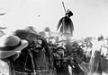
![Prospector riding "Misery", a famous camel that travelled a record 970 kilometres (600 mi) without water, 1895[9]](//upload.wikimedia.org/wikipedia/commons/thumb/8/8f/Misery_Coolgardie.jpg/120px-Misery_Coolgardie.jpg) Prospector riding "Misery", a famous camel that travelled a record 970 kilometres (600 mi) without water, 1895[9]
Prospector riding "Misery", a famous camel that travelled a record 970 kilometres (600 mi) without water, 1895[9] -
 Aboriginal people participate in ceremony to mark the opening of the Coolgardie Railway Line, 1896
 -
 Miners burn effigy of prospector who lied about gold discovery near Coolgardie, 1897
 -
 Coolgardie Chamber of Mines, c. 1900
![Prospector riding "Misery", a famous camel that travelled a record 970 kilometres (600 mi) without water, 1895[9]](https://en.wikipedia.org/wiki/File:Misery_Coolgardie.jpg)


Muslim Afghan cameleers
[edit]
When the Coolgardie gold rush occurred in 1894, the Afghan cameleers (so-called, although not allwere from Afghanistan) were quick to move in and provide transport for much-needed supplies. In March that year, a caravan of six men, forty-seven camels and eleven calves, set out across the desert from Marree to the goldfield. It arrived in July with the camels, carrying between 135 and 270 kilograms (298 and 595 lb) each, in good condition. Another fifty-eight camels for Coolgardie arrived by ship in Albany in September.[10]
By 1898 there were 300 members of this Muslim community in Coolgardie and 80 on average attended Friday prayer. Coolgardie held the main Muslim community in the colony at that time. There were no women amongst them, no marriages were performed and no burials, reflecting a relatively young and transient population. As with other structures in the town, simple mud and tin-roofed mosques were initially constructed. All of the community eventually relocated from Coolgardie generally to Perth, the new capital of Western Australia. Their success occasionally attracted resentment, with reports of unsolved attacks on animals.[11][12]
Transport
[edit]Great Eastern Highway (National Highway 94) runs through the town as Bayley Street. Just to the town's east, Highway 94 turns south onto Coolgardie-Esperance Highway, which heads towards Norseman, the starting point of the route east across the Nullarbor Plain.
Originally the narrow gauge railway to Kalgoorlie, the Eastern Goldfields Railway passed through Coolgardie, until 1968, when the new standard gauge line was built to the north on a new route.
Transwa's The Prospector stops 14 kilometres (8.7 mi) north of the town at Bonnie Vale. There is a very limited public bus service to the town on the Kalgoorlie to Perth route, although school bus services are more frequent.
Climate
[edit]| Climate data for Coolgardie | |||||||||||||
|---|---|---|---|---|---|---|---|---|---|---|---|---|---|
| Month | Jan | Feb | Mar | Apr | May | Jun | Jul | Aug | Sep | Oct | Nov | Dec | Year |
| Mean daily maximum °C (°F) | 33.3 (91.9) |
32.3 (90.1) |
29.4 (84.9) |
24.9 (76.8) |
20.3 (68.5) |
16.9 (62.4) |
16.1 (61.0) |
18.1 (64.6) |
22.0 (71.6) |
25.1 (77.2) |
29.3 (84.7) |
32.3 (90.1) |
25.0 (77.0) |
| Mean daily minimum °C (°F) | 17.0 (62.6) |
16.8 (62.2) |
15.1 (59.2) |
12.0 (53.6) |
8.6 (47.5) |
6.5 (43.7) |
5.2 (41.4) |
5.9 (42.6) |
7.9 (46.2) |
10.2 (50.4) |
13.4 (56.1) |
15.8 (60.4) |
11.2 (52.2) |
| Average precipitation mm (inches) | 23.4 (0.92) |
27.5 (1.08) |
25.3 (1.00) |
21.7 (0.85) |
28.0 (1.10) |
28.8 (1.13) |
23.8 (0.94) |
23.6 (0.93) |
13.6 (0.54) |
16.0 (0.63) |
16.4 (0.65) |
17.1 (0.67) |
265.2 (10.44) |
| Average rainy days (≥ 1 mm) | 2 | 2.1 | 2.5 | 2.7 | 3.7 | 4.3 | 4.5 | 3.7 | 2.4 | 2.2 | 2.1 | 1.9 | 34.1 |
| Average afternoon relative humidity (%) (at 3 pm) | 23 | 25 | 29 | 37 | 42 | 48 | 47 | 39 | 28 | 24 | 23 | 21 | 32 |
| Source: (temperatures 1897-1953, humidity 1938-1953, rainfall 1893-2024)[13][14] | |||||||||||||
Goldfields
[edit]In the 1890s four goldfields were gazetted with Coolgardie as reference point:
- Coolgardie Goldfield (1894)[15]
- East Coolgardie Goldfield (1894)[16]
- North Coolgardie Goldfield (1895)[17]
- North-east Coolgardie Goldfield (1896)[18]
Despite the changes to the Kalgoorlie region, Coolgardie still has a Mining Registrar.
In popular culture
[edit]The Denver City Hotel was the setting for the 2016 documentary Hotel Coolgardie,[19][20] while the town itself was used as the setting for the fictional town of Jardine in the 2022 mini-series Mystery Road: Origin.
See also
[edit]- Rescue of Modesto Varischetti from a nearby Bonnie Vale in 1907
- Burbanks Gold Mine
- Coolgardie Gold Mine
- Coolgardie safe
- Carnegie expedition of 1896
References
[edit]- ^ Australian Bureau of Statistics (28 June 2022). "Coolgardie (urban centre and locality)". Australian Census 2021.
- ^ Australian Bureau of Statistics (28 June 2022). "Coolgardie (urban centre and locality)". Australian Census 2021.
- ^ Australian Bureau of Statistics (27 June 2017). "Coolgardie (L) (Urban Centre/Locality)". 2016 Census QuickStats. Retrieved 5 January 2018.
- ^ "Our biggest nugget arrives in time for Gold Week". The Courier. Ballarat, Vic. 15 April 2004. Retrieved 2 September 2016.
- ^ "Class B objects refused an export permit - Prior to 2013". Movable Cultural Heritage Prohibited Exports Register. Canberra, ACT: Commonwealth of Australia Department of Communications and the Arts. Retrieved 3 September 2016.
- ^ Ford, Lyall (2001). Poorhouse to Paradise: The Adventures of a Pioneering Family in a North Queensland Town. Freshwater, Queensland: Taipan Press. p. 14. ISBN 0646332546.
- ^ Eastern Goldfields Historical Society inc. (7 March 2025). "Coolgardie". Eastern Goldfields Historical Society. Retrieved 7 March 2025.
- ^ Morris, Bernie & Milne, Rod (2008) Coolgardie's Railway Days Australian Railway History, June; July, 2008 pp183-196; 219-234
- ^ Reid, Arthur. Those Were the Days. Perth: Hesperian Press, 1986. ISBN 0-85905-101-3, p. 97
- ^ A History of Islam in Australia Archived 30 November 2007 at the Wayback Machine accessed: 27 May 2010
- ^ Simon Adams (2009). The Unforgiving Rope: Murder and Hanging on Australia's Western Frontier. UWA Press. p. 178. ISBN 978-1-921401-22-0.
- ^ Christine Stevens (2002). Tin Mosques and Ghantowns: A History of Afghan Cameldrivers in Australia. Paul Fitzsimons. p. 109. ISBN 978-0-9581760-0-2.
- ^ "Summary statistics COOLGARDIE (Site number: 012018)". Climate statistics for Australian locations. Commonwealth of Australia, Bureau of Meteorology. Retrieved 4 April 2024.
- ^ "Summary statistics Coolgardie (Site number: 012018)" (CSV). Commonwealth of Australia, Bureau of Meteorology. Retrieved 4 April 2024.
- ^ "Proclamation of Coolgardie Goldfield". Western Mail. Perth, WA. 14 April 1894. p. 4. Retrieved 17 February 2020.
- ^ "Government Gazette - Perth Friday September 21st". The West Australian. Perth, WA. 22 September 1894. p. 7. Retrieved 17 February 2020.
- ^ "News and Notes". The West Australian. Perth, WA. 23 May 1895. p. 4. Retrieved 17 February 2020.
- ^ "Mining Appointments". The Inquirer and Commercial News. Perth, WA. 6 March 1896. p. 5. Retrieved 17 February 2020.
- ^ Buckmaster, Luke (21 June 2017). "'I was crying, and I was angry': Hotel Coolgardie's shocking portrait of sexism in the outback". The Guardian. Retrieved 11 November 2023.
- ^ Croot, James (16 April 2022). "Hotel Coolgardie: The most disturbing Aussie doco ever made comes to DocPlay". Stuff. Retrieved 11 November 2023.
External links
[edit]| International | |
|---|---|
| National | |
| Other | |
Coolgardie, Western Australia
View on GrokipediaGeography
Location and Physical Features
Coolgardie is situated in the Goldfields-Esperance region of Western Australia, within the Shire of Coolgardie, approximately 558 km east-northeast of Perth, 40 km west of Kalgoorlie, and 370 km north of Esperance.[7][8][9] The town lies at coordinates 30°57′10″S 121°09′50″E.[10] The area has an elevation of 428 m above sea level.[11] Physical features include subdued relief characterized by gently undulating uplands dissected by broad valleys, with bands of low greenstone hills. Geologically, Coolgardie is part of the Yilgarn Craton, with a granite basement including Archaean greenstone intrusions in parallel belts that contribute to the local terrain and support mineral exploration. A prominent local hill and landmark in the Shire of Coolgardie is Mount Burges, located approximately 15 km northwest of the town with an elevation of about 550 m.[12][13] The landscape around the town features low, unremarkable hills and sparse vegetation typical of the semi-arid goldfields, as well as several ephemeral salt lakes within or partially within the Shire of Coolgardie. These include Lake Lefroy, the largest entirely within the shire at approximately 512 km², an expansive flat ephemeral salt pan near Kambalda and Widgiemooltha known for its hard crust used in land sailing and Australian land speed record attempts; the northern portion of Lake Cowan, a large ephemeral salt lake straddling the Coolgardie and Dundas Shires with an overall area of ~500–600 km² and significant shire portions including northern shores and mining areas; and Red Lake, a notable ephemeral salt lake east of Coolgardie in the approximate range of 50–100 km².[14][15][16][17]Climate and Environmental Conditions
Coolgardie experiences a hot semi-arid climate (Köppen classification BSh), characterized by high summer temperatures, mild winters, and low, erratic rainfall predominantly in the winter months. Average maximum temperatures peak at 33.3°C in January, dropping to 16.1°C in July, while average minimum temperatures range from 17.0°C in January to 5.2°C in July; the annual average maximum is 25.0°C and minimum 11.2°C, based on records from 1897 to 1953.[18] Annual rainfall averages 265.3 mm over 125 years (1893–2025), with the wettest month being June at 29.0 mm and the driest September at 13.5 mm; rain days (≥1 mm) total about 34 annually, reflecting infrequent but occasionally intense events, such as the record daily fall of 181.4 mm on 23 January 1967.[18][19]| Month | Average Max Temp (°C) | Average Min Temp (°C) | Average Rainfall (mm) | Average Rain Days |
|---|---|---|---|---|
| Jan | 33.3 | 17.0 | 23.2 | 2.0 |
| Feb | 32.3 | 16.8 | 27.4 | 2.1 |
| Mar | 29.4 | 15.1 | 25.3 | 2.5 |
| Apr | 24.9 | 12.0 | 22.0 | 2.7 |
| May | 20.3 | 8.6 | 27.6 | 3.6 |
| Jun | 16.9 | 6.5 | 29.0 | 4.3 |
| Jul | 16.1 | 5.2 | 23.8 | 4.5 |
| Aug | 18.1 | 5.9 | 23.5 | 3.7 |
| Sep | 22.0 | 7.9 | 13.5 | 2.4 |
| Oct | 25.1 | 10.2 | 15.9 | 2.2 |
| Nov | 29.3 | 13.4 | 16.8 | 2.1 |
| Dec | 32.3 | 15.8 | 16.9 | 1.9 |
| Annual | 25.0 | 11.2 | 265.3 | 34.0 |
History
Indigenous Lands and Pre-Gold Rush Exploration
The Coolgardie region formed part of the traditional territory of the Marlinyu Ghoorlie people, Indigenous groups whose language and cultural practices encompassed the Eastern Goldfields of Western Australia, including areas around Coolgardie, Kalgoorlie.[22] These groups maintained a nomadic lifestyle adapted to the semi-arid environment, depending on ephemeral waterholes, soaks, and granites for survival, supplemented by foraging for seeds, roots, and hunting native animals such as kangaroos and emus.[23] The local Aboriginal name for the site, derived from "Kurl-Kurti" or similar variants, denoted a stand of mulga trees (Acacia aneura) near a significant water source, highlighting the centrality of such features to Indigenous resource management and wayfinding in the landscape.[2] Prior to the gold discoveries of 1892, European awareness of the Coolgardie interior remained minimal, with explorations driven by surveys for potential agricultural or pastoral expansion from the Swan River Colony. In 1863, Henry Maxwell Lefroy led an expedition eastward from Perth, traversing roughly 200 miles into the interior and noting the prevalence of salt bush plains and occasional granite outcrops, though water scarcity limited progress.[24] This was followed by Charles Cooke Hunt's four expeditions between 1864 and 1866, originating from York, during which he mapped over 40 wells and rock holes—known as Hunt's Wells—along routes that skirted the future Coolgardie goldfields, approximately 300-400 kilometers east of Perth; these markers proved instrumental for later overland access but underscored the region's marginal viability for settlement due to unreliable rainfall averaging under 250 mm annually and frequent droughts.[25][26] John Forrest's 1869 expedition, commissioned to investigate traces of the lost Ludwig Leichhardt party, ventured northeast from the Murchison River and Esperance Bay into unexplored desert country near modern Laverton—about 285 kilometers northeast of Coolgardie—covering over 1,600 kilometers in 113 days while documenting vast expanses of spinifex-covered sandplains, salt lakes, and sparse timber, with no evidence of permanent watercourses to support colonization.[27][28] In 1875, during his transcontinental expedition from South Australia to Western Australia, explorer Ernest Giles skirted the Coolgardie area to the north, reaching Ularring (approximately 100-150 km northeast of Coolgardie) on October 13, where his party was attacked by a large group of Aboriginal people; Giles documented encounters with dense scrubs, challenging water scarcity, and the harsh interior landscape, further highlighting the difficulties of traversal in the region.[29][30] These efforts yielded practical data on terrain and hydrology but revealed no economic incentives for immediate occupation, leaving the area unpopulated by Europeans until prospectors arrived in the early 1890s; interactions with local Aboriginal people during these traverses were incidental, often involving exchanges of information about water sources.[31] No permanent European outposts or pastoral leases were established in the immediate Coolgardie vicinity before 1892, preserving Indigenous land use patterns amid the isolation.[32]Gold Discovery and Rapid Settlement (1892–1897)
In late August 1892, prospector William Ford identified alluvial gold deposits at a site known as Fly Flat in the arid interior of Western Australia, approximately 550 kilometers east of Perth. Arthur Wellesley Bayley, partnering with Ford, assisted in extracting the gold, amassing 554 ounces (15.7 kg), which Bayley transported to the warden at Southern Cross on 17 September 1892 to register the claim named Bayley's Reward.[33] This discovery, confirmed by the substantial yield, ignited the Coolgardie gold rush, drawing immediate attention from miners in nearby fields like Southern Cross and sparking a migration of prospectors seeking fortune in the previously unproven region.[34][35] The influx began rapidly as word spread via telegraph and word-of-mouth; by late 1892, dozens of tents dotted Fly Flat, renamed Coolgardie after the local Aboriginal term possibly meaning "water hole." In March 1893, Bayley and Ford sold their claim for £6,000 plus a one-sixth interest to investors Sylvester Browne and Gordon Lyon, fueling further investment and prospecting. The Western Australian government laid out the townsite and proclaimed Coolgardie a township on 25 August 1893, formalizing streets and allotments amid burgeoning claims.[33][36] Settlement expanded chaotically with makeshift shanties, stores, and pubs serving the growing population, reliant on camel teams and horses for supplies due to the lack of roads and water scarcity. The Municipality of Coolgardie was established in 1894 to manage governance and services for the swelling community. By 1897, the town had become Western Australia's third-largest, with approximately 15,000 residents in the urban area and another 10,000 in surrounding camps, supported by over 700 mining companies actively operating leases.[2][37] Tensions arose from fraudulent claims, exemplified by miners burning an effigy of a prospector in 1895 who had exaggerated discoveries near Lake Cowan to attract followers, highlighting the speculative fervor and community self-policing during the rush.Boom Period and Infrastructure Development (1898–1903)
Following the initial gold rush, Coolgardie experienced a sustained boom from 1898 to 1903, characterized by population stability and expanded mining operations. By 1898, the town supported 15,000 residents, with an additional 10,000 in the surrounding district, making it Western Australia's third-largest population center. Over 700 mining companies were active, reflecting intensive prospecting and development of quartz reefs. This period saw the registration of numerous leases with the London Stock Exchange, fueling investment in battery plants and shaft sinking.[37][2] Infrastructure development accelerated to accommodate the growing settlement and arid conditions. Construction of the Goldfields Water Supply Scheme commenced in 1898, engineered by C. Y. O'Connor, featuring a reservoir on the Helena River, eight steam-powered pumping stations, and 566 kilometers of steel pipes delivering water to Coolgardie. The scheme, costing approximately £2.7 million, addressed chronic water shortages that had previously limited expansion, with the pipeline reaching the town and officially opening on January 22, 1903. Supporting urban growth, the town installed electric street lighting and opened Western Australia's first public swimming pool by 1900.[38][39] Commercial and public facilities proliferated, underscoring the era's prosperity. By 1900, Coolgardie hosted 23 hotels, three breweries, six banks, and two stock exchanges, alongside a hospital and multiple newspapers—three daily and four weekly editions. The 1899 Mining World Exhibition drew 61,000 visitors, showcasing gold specimens and machinery, which highlighted the field's economic significance. Permanent structures like the Chamber of Mines and educational institutions emerged, transitioning from tent city to established townscape.[37]Decline, Revival Attempts, and Modern History (1904–Present)
Following the peak of the gold boom, Coolgardie's mining output declined as shallow alluvial and reef deposits were exhausted, prompting prospectors to migrate to richer fields like Kalgoorlie-Boulder where deeper, higher-grade ores were more accessible via advancing technology such as cyanide processing.[37] By 1907, smaller operations were increasingly consolidated by larger companies, but overall production fluctuated downward due to diminishing grades at depth. In March 1907, miner Modesto Varischetti was trapped for nine days underground in the flooded Westralia mine at nearby Bonnie Vale, highlighting the hazards faced by workers during this period of industry contraction.[40][41] The population, which had reached approximately 25,000 in 1897, began a steep drop in the early 1900s, exacerbated by World War I labor shortages and economic pressures that halted many operations.[2] By 1921, the town had shrunk significantly, with residents relocating for reliable employment.[42] Revival efforts in the interwar and mid-20th centuries were limited, relying on sporadic nickel and gold prospecting, but failed to reverse the trend as global commodity prices remained low and infrastructure decayed.[37] Underground mining persisted until 1961 at sites like the historical reefs, yielding 324,000 ounces at an average 22.7 grams per tonne, yet insufficient to sustain growth amid rising costs.[43] A modest resurgence occurred in the late 20th century through heritage preservation and tourism promotion, stabilizing the population at around 200 by 1980, though economic dependence shifted toward service roles rather than extraction.[37] More substantive attempts emerged in the 2010s with renewed exploration under high gold prices, including drilling programs targeting extensions of known high-grade zones.[43] In the modern era, Coolgardie has functioned primarily as a heritage tourism hub and regional service center with a population of about 850, drawing visitors to preserved sites amid its semi-ghost town character.[44] Mining revival accelerated post-2020, fueled by soaring gold prices and technological advances enabling deeper extraction; for instance, projects like the Coolgardie Gold Mine plan an 18% output increase by 2026 via automation.[45] Infrastructure improvements, such as the 30-kilometer realignment of the Coolgardie-Esperance Highway at Emu Rocks, support logistics for renewed operations.[46] Local governance has faced challenges, including over $27 million in debts by 2025, leading to resisted merger proposals with Kalgoorlie-Boulder and a near-suspension averted through budget reforms adopted in July 2025.[47][48][49] These efforts emphasize economic diversification into industrial estates and job creation, though fiscal mismanagement critiques persist from state oversight.[50]Economy
Mining Industry and Resource Extraction
The mining industry in Coolgardie centers on gold extraction, stemming from the September 1892 discovery of quartz gold by prospectors Arthur Bayley and William Ford, which sparked Western Australia's most significant gold rush and established the town as a key hub.[1] [34] Deposits occur primarily in narrow veins within greenstone belts, requiring underground and open-pit methods for ore recovery.[45] Historical operations during the late 19th and early 20th centuries involved numerous small-scale mines, with the region contributing to the Eastern Goldfields' output that propelled Western Australia's gold production to prominence by the 1890s.[51] Specific sites like Tindals Mine yielded 1.241 million tonnes of ore at 4.15 g/t Au, producing 5,150 kg of gold by June 1994.[52] The Shire of Coolgardie, encompassing the area, ranks as the top mineral producer in the Goldfields region, bolstered by both gold and nickel activities.[2] Modern gold mining persists through projects such as the Coolgardie Gold Operations, which have produced over 300,000 ounces since 2008 while expanding known resources.[53] In October 2025, Auric Mining acquired the Burbanks gold processing plant, capable of 180,000 tonnes per annum, located 10 km south of Coolgardie, to support regional extraction.[54] Ore reserves for the Coolgardie Gold Project were updated in 2022, affirming ongoing viability.[55] Nickel extraction supplements gold in the shire, with operations like the Lanfranchi Mine and the Coolgardie Nickel project, where Future Battery Minerals acquired an 85% stake in March 2024 to consolidate holdings in sulfide deposits.[56] [57] These activities underscore the area's transition from boom-era alluvial and reef mining to sustained, mechanized resource recovery amid fluctuating commodity prices.[2]Tourism, Agriculture, and Diversification Efforts
Tourism in Coolgardie centers on its gold rush heritage, with key attractions including the Coolgardie Goldfields Exhibition and Visitors Centre, which serves as the gateway to the region's history and features exhibits on mining artifacts and pioneer life.[58] The town is the starting point for the 965 km Golden Quest Discovery Trail, a self-drive route through Goldfields ghost towns, abandoned mines, and historical sites accessible by 2WD vehicles.[59] Additional attractions include heritage sites such as:- Warden Finnerty's Residence
- Lions Lookout on Hunt Street
- the Varischetti Mine Rescue exhibit at the museum
- the ruins of the Premier Hotel in Kunanalling
- the Shire's participation in the Nullarbor Links, recognized as the world's longest golf course at 1,365 km with 18 holes spanning participating towns and locations, including holes at Kambalda and Widgiemooltha within the Shire.[60][61][62]
- Rowles Lagoon
- Burra Rock Conservation Park
- Cave Hill Nature Reserve
- Gnarlbine Rock (23 km south of Coolgardie, a granite outcrop serving as a historical Aboriginal water source developed into Well No. 22 by C.C. Hunt on Hunt's Track, with other wells and water sources of interest for exploration)
- Wallaroo Rock Conservation Park
- Victoria Rock Nature Reserve
Demographics and Society
Population Dynamics and Trends
The population of Coolgardie experienced explosive growth following the 1892 gold discovery by Arthur Bayley and William Ford, surging from negligible numbers to support around 25,000 residents by 1897 amid the gold rush peak, driven by influxes of prospectors and service industries.[2] This made it Western Australia's third-largest settlement, with the town proper estimated at 15,000 by 1898, supplemented by surrounding district populations exceeding 10,000, as mining leases proliferated to over 700.[37] Growth was fueled by alluvial gold yields and infrastructure like the 1896 railway, but it masked underlying volatility tied to finite surface deposits.[2] Post-1900, depletion of easily accessible gold and redirection of efforts to deeper quartz reefs in adjacent Kalgoorlie triggered a precipitous decline, with the population contracting to under 200 by the 1920s, rendering much of the town a near-ghost settlement as miners departed for more viable fields.[42] This bust phase persisted through the mid-20th century, with minimal rebound until sporadic nickel and gold revivals in the broader Goldfields-Esperance region post-World War II, though Coolgardie town's numbers stabilized at low levels, reflecting broader resource-dependent demographics in remote Western Australian outback areas.[74] In recent decades, the town's population has hovered below 1,000, with the 2016 Australian Census recording 865 residents and the 2021 Census declining to 763, indicative of ongoing challenges like outmigration for urban opportunities and aging infrastructure amid intermittent mining fluctuations.[75] [76] The Shire of Coolgardie, encompassing wider localities like Kambalda, reports a larger 3,478 in 2021, but town-specific trends show stagnation or slight contraction, with growth rates lagging regional Western Australia averages due to limited diversification beyond extractive industries.[77] [74] Current estimates place the town at approximately 850, sustained by tourism to heritage sites, residual mining, and commuting to employment in nearby Kalgoorlie, though vulnerability to commodity cycles persists.[78]Cultural Composition and Community Life
The Shire of Coolgardie exhibits a cultural composition shaped by its mining heritage and remote location, featuring a majority population of Anglo-Australian descent alongside a notable Indigenous component. The 2021 Australian Census recorded 3,478 residents, with top-reported ancestries being Australian (33.2%) and English (30.2%), followed by Australian Aboriginal (8.9%).[79] An identical 8.9% (311 individuals) identified as Aboriginal and/or Torres Strait Islander, whose primary ancestries included Australian Aboriginal (90.4%) and Australian (34.4%).[79][80] Country of birth data reveals 60.0% Australian-born, 7.6% from New Zealand, and 2.1% from England, indicating modest multicultural influences primarily from English-speaking nations.[79] Linguistic and religious profiles further highlight homogeneity, with English spoken at home by the vast majority and small instances of Indigenous languages like Wangkatha (0.5% overall, 5.5% among Indigenous residents).[79][80] Religiously, 43.1% professed no religion, 10.4% identified as Catholic, and 8.6% as Anglican, reflecting secular trends common in regional Australia.[79] Local churches serve as key community institutions supporting these affiliations, including the heritage-listed St Mary's Catholic Church constructed in 1902, St Andrew's Anglican Church, Coolgardie Gospel Chapel, and ChurchWest Coolgardie.[81][82][83][84] Among the Indigenous population, 87.5% spoke only English at home, underscoring assimilation patterns while preserving elements of traditional language use.[80] Community life revolves around tight-knit social structures, local organizations, and annual events that reinforce outback resilience and camaraderie. The Coolgardie Returned and Services League (RSL) sub-branch functions as a key venue for veterans' support, social functions, and volunteer activities; it recently obtained a club licence allowing members and their guests to consume beverages on site, hosting meetings and events like fun days during Volunteer's Week.[85][86] The Coolgardie Outback Festival, held annually, features rodeo competitions, live music, markets, and youth activities, attracting thousands and bolstering groups such as the RSL through fundraising.[87] Similarly, Coolgardie Day on the third Sunday in September promotes family-oriented celebrations of local history and spirit.[88] The Shire of Coolgardie supports cultural initiatives, including a creative plan to highlight regional diversity, talent, and events like community tree plantings and mental health gatherings.[89] Indigenous-specific groups, such as the Coolgardie Aboriginal Playgroup, facilitate early childhood engagement and cultural continuity.[90] Recreation centers in Coolgardie and nearby towns serve as hubs for sports and cultural pursuits, adapting to the shire's sparse, transient mining workforce.[91]Government and Administration
Local Governance Structure
The Shire of Coolgardie functions as the local government authority overseeing the town of Coolgardie and surrounding districts in Western Australia, including the towns of Widgiemooltha and Kambalda, encompassing an area of 30,400 square kilometres with a population exceeding 3,600 residents.[92] This shire-level administration handles regional services including road maintenance, land-use planning, waste collection, and community development initiatives.[93] Governance occurs through an elected council comprising a Shire President and multiple councillors, with members serving four-year terms determined by periodic elections with all residents and ratepayers eligible to vote.[94][78] The council elects its president internally, who, as of October 2025, is Cr. Paul Wilcox, supported by Deputy President Cr. Tony Ball and other elected representatives responsible for policy-making and budgetary oversight.[95] Ordinary council meetings are held regularly to deliberate on local matters, with decisions implemented by a chief executive officer and administrative staff.[96] The structure aligns with Western Australia's local government framework under the Local Government Act 1995, empowering the council to enforce planning schemes, manage public reserves, and address community needs while adhering to state oversight from the Department of Local Government, Sport and Cultural Industries.[97] Recent elections, such as those in October 2025, fill councillor positions to maintain representation across the shire's dispersed communities.Financial Mismanagement and Recent Controversies
In August 2025, the Western Australian Department of Local Government, Sport and Cultural Industries issued a show cause notice to the Shire of Coolgardie, citing serious concerns over the local government's financial management and governance practices.[98] The notice followed an audit revealing "shocking mismanagement and poor governance," including the improper dismissal of employees, with one former staff member reportedly relocating to the Caribbean amid unresolved compensation claims.[99] Ratepayer-initiated no-confidence motions against councillors, passed in July 2025, highlighted dissatisfaction with leadership decisions, including proposals for significant rate increases that defied ministerial warnings against treating residents as "cash cows."[100] [101] The shire's mounting debt exacerbated these issues, with the council's financial viability described as precarious by Local Government Minister Hannah Beazley.[102] Contributing to the turmoil was the suspension and subsequent termination of Chief Executive Officer Andrew Trail in November 2024 over allegations of toxic workplace culture, followed by his dismissal on July 9, 2025.[103] Trail became the subject of a Crime and Corruption Commission investigation after revelations of an attempted $100,000 reimbursement claim, prompting resident demands for state intervention to hold him accountable.[104] Community meetings in October 2025 underscored ongoing frustration, with locals criticizing the council's handling of these matters while expressing mixed relief over the avoidance of immediate suspension.[105] On October 13, 2025, Minister Beazley opted not to suspend the council, granting a 12-month probationary period contingent on mandatory financial management training for councillors, 3-monthly updates to the state, and collaboration with administration on strategic planning.[106] [48] Despite this reprieve, Beazley reiterated "very serious concerns" about the shire's long-term sustainability, attributing risks to persistent governance lapses rather than external factors.[107] The episode reflects broader challenges in rural Western Australian local governments, where limited revenue from declining populations amplifies the impact of administrative errors, though state oversight has prevented outright dissolution.[108]Infrastructure
Transportation Networks
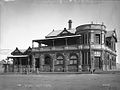
Coolgardie's transportation networks primarily rely on road infrastructure, reflecting the town's role as a regional hub in Western Australia's Goldfields-Esperance area. The Great Eastern Highway, a major arterial route, connects Coolgardie eastward to Kalgoorlie-Boulder approximately 40 kilometers away and westward to Perth over 550 kilometers via Southern Cross, Merredin, and Kellerberrin, supporting heavy freight haulage for mining operations and general travel. This highway forms part of the strategic Port Augusta to Perth corridor, handling significant volumes of goods vital to the eastern goldfields' economy. Branching southward from Coolgardie, the Coolgardie-Esperance Highway extends 370 kilometers to the coastal port of Esperance via the towns of Widgiemooltha, Norseman and Salmon Gums, linking the interior goldfields to southern export routes and facilitating agricultural and mineral transport. Ongoing upgrades, including pavement rehabilitation and widening, address flood vulnerabilities and enhance resilience for oversized vehicles common in resource extraction. Local roads, such as Coolgardie North Road, Jaurdi Hills Road, Burra Rocks Road, and Victoria Rocks Road, are managed by the Shire of Coolgardie and primarily consist of unsealed gravel tracks suited for mining access and tourism access, with periodic closures due to weather or maintenance. The state-run Prospector passenger train provides regular services to Perth, with a stop at Bonnie Vale station approximately 14 km north of Coolgardie via sealed road upon advance booking, as the train does not normally stop there otherwise. The Prospector continues to Kalgoorlie station.[109] Rail networks originated with the Eastern Goldfields Railway, constructed during the 1890s gold rush to connect remote prospects to coastal ports. The line from Southern Cross reached Coolgardie on March 23, 1896, with the station and goods shed completed as part of this extension, enabling daily passenger and freight services to Perth that spurred population growth. Initially, trains operated bidirectionally each day, transporting ore, supplies, and workers essential to the boom. The infrastructure later extended to Kalgoorlie, solidifying the network's role in regional development. The line was rerouted away from Coolgardie in the early 1970s, leading to the closure of the Coolgardie station and explaining why the nearest public siding for the Prospector train is now at Bonnie Vale. In the present day, the railway supports private freight operations for mining exports, primarily iron ore and gold. Aviation relies on Kalgoorlie-Boulder Airport (KGI), 38 kilometers east, which handles commercial flights to Perth operated by Qantas and Virgin Australia, with resident fare programs reducing costs for regional travelers. Coolgardie itself maintains a small, unsealed aerodrome (YCLG) for general aviation and emergency use, but no scheduled commercial services. Ground connections to KGI include bus routes, taxis, and private vehicles, with travel times around 30-45 minutes under normal conditions.Public Services and Utilities
The Shire of Coolgardie manages wastewater services through its treatment plant, where sewage is processed to remove or break down organic matter prior to disposal or reuse, with operations governed by a customer service charter outlining terms for connection, maintenance, and potential discontinuation for non-compliance.[110][111] Potable water supply to Coolgardie is provided by Water Corporation via the Goldfields Pipeline, delivering treated surface water from distant reservoirs to regional consumers, including provisions for non-potable uses under the Shire's licensed operations.[112][113] Electricity distribution falls under Western Power, with the Shire holding ancillary licenses for power generation activities amid broader regional infrastructure.[114][115] Healthcare services are centered at the Coolgardie Health Centre, a facility offering general practice, nurse-led clinics, and emergency care, staffed by resident doctors such as those appointed in 2023 with expertise in rural medicine.[116][117] Supplementary support includes periodic visits by St John Ambulance for health clinics and events, integrated with the Shire's community assistance framework.[118] Education is provided through Coolgardie Primary School, a public institution serving kindergarten to Year 6 students with a focus on community development in the goldfields context, and the Christian Aboriginal Parent-Directed School (CAPS), an independent facility enrolling approximately 98 students from pre-primary to Year 12 with a Christian educational emphasis.[119][120][121] The Shire of Coolgardie manages the Coolgardie Swimming Pool, a 25-metre, 4-lane outdoor pool with step access, outdoor change rooms, showers, shaded grass areas, and BBQs, available for public use by residents.[122] Waste management, including weekly collection of 240-litre household rubbish bins from residential properties and operation of rubbish tips such as the Coolgardie Waste Facility—where ratepayers receive annual tip passes allowing 10 visits for trailer loads of household waste—is handled locally by the Shire under environmental licenses covering putrescible and solid waste facilities.[123][124][115]Heritage and Culture
Preservation of Historical Sites
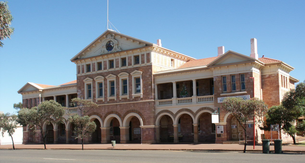
Coolgardie retains a significant number of heritage-listed structures from its 1890s gold rush origins, with 27 places entered on the State Register of Heritage Places as managed by the Department of Planning, Lands and Housing.[125] These include key public buildings constructed amid rapid population growth, such as the Coolgardie Post Office complex, designed by government architect George Temple-Poole and expanded between 1894 and 1898 to accommodate postal and telegraph demands driven by mining booms.[126] The Shire of Coolgardie has prioritized conservation through grant-funded initiatives, including a $500,000 state government allocation in 2004 for restoring public heritage buildings like the post office and courthouse, addressing deterioration from environmental exposure and deferred maintenance. Adaptive reuse projects exemplify ongoing efforts to sustain these sites' viability, such as the 2019 Shire-commissioned refurbishment of the Coolgardie Post Office complex, which involved facade repairs, repainting, and reconstruction elements to enable contemporary functions while preserving original fabric.[127] Similarly, specialist conservation by firms like K&S Heritage has targeted the 1898 Warden's Court, a stone and brick edifice representative of goldfields judicial architecture, through structural stabilization and material restoration completed in recent years.[128] Ben Prior Park, redeveloped and reopened in February 2021, functions as Western Australia's largest open-air museum, showcasing relocated mining-era artifacts and structures to interpret Coolgardie's pioneer history for public education.[129] The National Trust of Australia (WA) maintains properties like Warden Finnerty's Residence, a 1895 stone dwelling built for Coolgardie's first mining warden, emphasizing interpretive programs alongside physical upkeep to highlight administrative roles in early colonial resource extraction.[130] State-level oversight via the Heritage Council ensures compliance with conservation principles, as seen in entries for the Coolgardie Railway Station and Goods Shed, which retain late-19th-century features despite adaptive alterations, underscoring the tension between historical authenticity and functional reuse in arid climates prone to material degradation.[131] Local advocacy, including Shire-led heritage promotion through the Coolgardie Goldfields Exhibition and Visitors Centre, supports tourism-driven funding for preservation, though challenges persist from economic pressures in a declining population center.[58]Representation in Media and Popular Culture
The 2016 Australian documentary Hotel Coolgardie, directed by Pete Gleeson, provides one of the most prominent modern depictions of the town, following two young Finnish backpackers employed as barmaids at the local pub amid a predominantly male mining workforce.[132] The film portrays Coolgardie as a remote, rough outback settlement characterized by heavy drinking, overt sexism, and cultural clashes between transient workers and outsiders, drawing criticism from some residents for exaggerating negative stereotypes and ignoring community positives.[133] Gleeson defended the observational style as unfiltered reality, though reviewers noted its unflinching focus on "toxic masculinity" in isolated mining towns.[134] This documentary inspired the 2023 fictional horror-thriller The Royal Hotel, directed by Kitty Green and starring Julia Garner, which relocates similar themes of female vulnerability in a male-dominated pub to a generic Australian outback town modeled after Coolgardie but depicted as more desolate and abandoned than the actual location.[135] The film amplifies tensions from the source material, including harassment and isolation, but alters specifics like population density to heighten dramatic effect, diverging from verifiable accounts of Coolgardie's ongoing, albeit small, community of around 800 residents as of the 2021 census.[136] Earlier cinematic representations include the 1988 drama Boundaries of the Heart, starring Wendy Hughes, which was filmed on location in Coolgardie and explores isolation and moral dilemmas in a gold-mining town setting reminiscent of the area's historical boom era.[137] More recent productions filmed in the area include the 2024 sports drama Kid Snow, depicting 1970s outback tent boxing and shot in Coolgardie and nearby Goldfields locations,[138] and the 2022 TV mini-series Mystery Road: Origin, a prequel exploring outback police life and Indigenous themes, with scenes filmed in Coolgardie.[139] Coolgardie has appeared sporadically in broader Australian gold rush documentaries, such as excerpts in Constructing Australia: Pipe Dreams (2007), which contextualizes the 1890s rushes without centering the town as a primary narrative focus.[140] Literary depictions remain limited in popular culture, with the town more often referenced in historical nonfiction on Western Australia's goldfields than in fiction or mainstream novels.[141]References
- https://en.wikisource.org/wiki/History_of_West_Australia/John_Forrest