Hubbry Logo
Liancourt RocksLiancourt RocksMain
Open search
Liancourt Rocks
Community hub
Liancourt Rocks
logo
8 pages, 0 posts
0 subscribers
Be the first to start a discussion here.
Liancourt Rocks
Liancourt Rocks
from Wikipedia

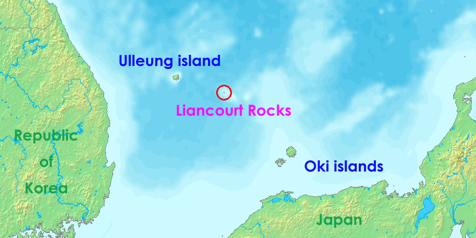
The Liancourt Rocks,[2] known in Korea as Dokdo (Korean: 독도)[a] and in Japan as Takeshima (Japanese: 竹島),[b] are a group of islets in the Sea of Japan between the Korean Peninsula and the Japanese archipelago administered by South Korea. The Liancourt Rocks comprise two main islets and 35 smaller rocks; the total surface area of the islets is 19 hectares (47 acres) and the highest elevation of 168.5 metres (553 ft) is on the West Islet. The Liancourt Rocks lie in rich fishing grounds that may contain large deposits of natural gas.[4] The English name Liancourt Rocks is derived from Le Liancourt,[c] the name of a French whaling ship that came close to being wrecked on the rocks in 1849.[5]

Key Information

While South Korea controls the islets, its sovereignty over them is contested by Japan. North Korea also claims the territory. South Korea classifies the islets as Dokdo-ri, Ulleung-eup, Ulleung County, North Gyeongsang Province,[6] while Japan classifies the islands as part of Okinoshima, Oki District, Shimane Prefecture.[7]

Geography

[edit]
A steep, rocky island surrounded by dark blue sea
A round rocky island, with an empty port. Seagulls block some of the frame.
The West island (top) and the East island (bottom)

The Liancourt Rocks consist of two main islets and numerous surrounding rocks. The two main islets, called Seodo (서도; 西島; lit. western island) and Dongdo (동도; 東島; lit. eastern island) in Korean and Ojima (男島; "Male Island") and Mejima (女島; "Female Island") in Japanese, are 151 metres (495 ft) apart.[8] The Western Island is the larger of the two, with a wider base and higher peak, while the Eastern Island offers more usable surface area.

Altogether, there are about 90 islets and reefs,[8][dead link] volcanic rocks formed in the Cenozoic era, more specifically 4.6 to 2.5 million years ago. A total of 37 of these islets are recognized as permanent land.[verification needed]

The total area of the islets is about 187,554 square metres (46.346 acres), with their highest point at 168.5 metres (553 ft) on the West Islet.[8] The western islet is about 88,740 square metres (21.93 acres); the eastern islet is about 73,300 square metres (18.1 acres).[8] The western islet consists of a single peak and features many caves along the coastline. The cliffs of the eastern islet are about 10 to 20 metres (33 to 66 ft) high. There are two large caves giving access to the sea, as well as a crater.[verification needed]

In 2006, a geologist reported that the islets formed 4.5 million years ago and are (in a geological sense) quickly eroding.[9]

Tourism

[edit]

Restricted public access to the rocks for a variety of purposes is provided by ferry from Ulleng Island.[10] In 2022, 280,312 tourists visited the islands, averaging 500 visitors per day.[1]

Distances

[edit]

The Liancourt Rocks are located at about 37°14′N 131°52′E / 37.233°N 131.867°E / 37.233; 131.867.[11] The western islet is located at 37°14′31″N 131°51′55″E / 37.24194°N 131.86528°E / 37.24194; 131.86528 (West Islet) and the Eastern Islet is located at 37°14′27″N 131°52′10″E / 37.24083°N 131.86944°E / 37.24083; 131.86944 (East Islet).

The Liancourt Rocks are situated at a distance of 211 kilometres (114 nmi) from the main island of Japan (Honshu) and 216.8 kilometres (117.1 nmi) from mainland South Korea. The nearest Japanese island, Oki Islands, is at a distance of 157 kilometres (85 nmi),[12] and the nearest Korean island, Ulleungdo, is 87.4 kilometres (47.2 nmi).[13][12]

Climate

[edit]
The Liancourt Rocks viewed from the North

Owing to their location and small size, the Liancourt Rocks can have harsh weather. If the swell is greater than 3 to 5 metres, then landing is not possible, so on average ferries can only dock about once in forty days.[14] Overall, the climate is warm and humid, and heavily influenced by warm sea currents. Precipitation is high throughout the year (annual average—1,383.4 millimetres or 54.46 inches), with occasional snowfall.[15] Fog is common. In summer, southerly winds dominate. The water around the islets is about 10 °C (50 °F) in early spring, when the water is coldest, warming to about 24 °C (75 °F) in late summer.

Ecology

[edit]
Japanese sea lions at Liancourt Rocks during a Japanese sealing operation in 1934

The islets are volcanic rocks, with only a thin layer of soil and moss.[16] About 49 plant species, 107 bird species, and 93 insect species have been found to inhabit the islets, in addition to local marine life with 160 algal and 368 invertebrate species identified.[17] Although between 1,100 and 1,200 litres of fresh water flow daily, desalinization plants have been installed on the islets for human consumption because existing spring water suffers from guano contamination.[citation needed] Since the early 1970s trees and some types of flowers were planted.[citation needed] According to historical records, there used to be trees indigenous to Liancourt Rocks, which have supposedly been wiped out by overharvesting and fires caused by bombing drills over the islets.[d] A recent investigation, however, identified ten spindle trees aged 100–120 years.[18][19] Cetaceans such as minke whales, orcas, and dolphins are known to migrate through these areas.[20][21][22]

Pollution and environmental destruction

[edit]

Records of the human impact on the Liancourt Rocks before the late 20th century are scarce, although both Japanese and Koreans claim to have felled trees and killed Japanese sea lions there for many decades.[23][24]

There are serious pollution concerns in the seas surrounding the Liancourt Rocks. In 2004, a malfunction in the sewage water treatment system established on the islets caused sewage produced by inhabitants of the Liancourt Rocks, such as South Korean Coast Guards and lighthouse staff, to be dumped directly into the ocean. Significant water pollution was observed; sea water turned milky white, sea vegetation died, and coral reefs were calcified. The pollution also caused loss of biodiversity in the surrounding seas. In November 2004, eight tons of malodorous sludge was being dumped into the ocean every day.[25] Efforts have since been made by both public[26] and private[27] organizations to reduce the level of pollution surrounding the Rocks.

Construction

[edit]

South Korea has carried out construction work on the Liancourt Rocks; by 2009, the islands had a lighthouse, helicopter pad,[28] and a police barracks.[29] In 2007, two desalination plants were built capable of producing 28 tons of clean water every day.[30] Both of the major South Korean telecommunications companies have installed cellular telephone towers on the islets.[31]

History

[edit]
Japanese map depicting the Liancourt Rocks in "Matsushima Ezu" (松嶋絵図), 1656, (Tottori Prefecture)

Whaling

[edit]

U.S. and French whaleships cruised for right whales off the rocks between 1849 and 1892.[32]

Demographics and economy

[edit]
The base that houses South Korean police guards on the Liancourt Rocks' East Islet

In February 2017, there were two civilian residents, two government officials, six lighthouse managers, and 40 members of the coast guard living on the islets.[1] Since the South Korean coast guard was sent to the islets, civilian travel has been subject to South Korean government approval; they have stated that the reason for this is that the islet group is designated as a nature reserve.[33]

In March 1965, Choi Jong-duk moved from the nearby Ulleungdo to the islets to make a living from octopus fishing. He also helped install facilities from May 1968. In 1981, Choi Jong-duk changed his administrative address to the Liancourt Rocks, making himself the first person to officially live there. He died there in September 1987. His son-in-law, Cho Jun-ki, and his wife also resided there from 1985 until they moved out in 1992. Meanwhile, in 1991, Kim Sung-do and Kim Shin-yeol transferred to the islets as permanent residents, still continuing to live there. In October 2018, Kim Sung-do died, thus Kim Shin-yeol is the last civilian resident still living on the islands.[34][35][36][37]

The South Korean government gave its approval to allow 1,597 visitors to visit the islets in 2004. Since March 2005, more tourists have received approval to visit. The South Korean government lets up to 70 tourists land at any given time; one ferry provides rides to the islets every day.[38] Tour companies charge around 350,000 Korean won per person (about US$310 as of 2019).[39]

Sovereignty dispute

[edit]

Sovereignty over the islands has been an ongoing point of contention in Japan–South Korea relations. There are conflicting interpretations about the historical state of sovereignty over the islets.

South Korean claims are partly based on references to an island called Usando (우산도; 于山島; 亐山島) in various medieval historical records, maps, and encyclopedia such as Samguk Sagi, Annals of Joseon Dynasty, Dongguk Yeoji Seungnam, and Dongguk munhon bigo. According to the South Korean view, these refer to today's Liancourt Rocks.[citation needed] Japanese researchers of these documents have claimed the various references to Usan-do refer at different times to Jukdo, its neighboring island Ulleungdo, or a non-existent island between Ulleungdo and Korea.[e] The first printed usage of the name Dokdo was in a Japanese log book in 1904.[40]

North Korea also regards the islands as Korean, and as it claims the entirety of Korea, North Korea claims the islands as its own and contests Japan's claim to the islands alongside South Korea.[41]

Natural Monument of South Korea

[edit]

The Liancourt Rocks were designated as a breeding ground for band-rumped storm petrels, streaked shearwaters, and black-tailed gulls as Natural Monument #336 of South Korea on November 29, 1982.[42]

See also

[edit]

Notes

[edit]

Inline citations

[edit]
  1. ^ a b c "Dokdo Residents". Gyeongsangbuk-do Province. Retrieved 17 February 2021.
  2. ^ Fern 2005, p. 78: "Since the end of World War II, Japan and Korea have contested ownership of these islets, given the name Liancourt Rocks by French whalers in the mid-1800s and called that by neutral observers to this day".
  3. ^ BBC staff 2006.
  4. ^ BBC staff 2008.
  5. ^ Kirk 2008.
  6. ^ "Ordinance No.1395 on Ri-Administration, Ulleung County" (in Korean). Ulleung County. 7 April 2000.
  7. ^ "Japan's Consistent Position on the Territorial Sovereignty over Takeshima". Ministry of Foreign Affairs of Japan. Retrieved 23 September 2025.
  8. ^ a b c d Gyeongsangbuk-do Province 2017b.
  9. ^ "독도ㆍ울릉도 `침몰하고 있다'"<손영관교수>. Yonhap News Agency (in Korean). 1 December 2006. Archived from the original on 22 January 2016. Retrieved 1 January 2015.
  10. ^ "독도 : 독도입도안내 페이지 입니다.아름다운 신비의 섬 – 울릉군". www.ulleung.go.kr. Archived from the original on 13 October 2022. Retrieved 13 October 2022.
  11. ^ Gyeongsangbuk-do Province 2017c.
  12. ^ a b "The Issue of Takeshima". Ministry of Foreign Affairs of Japan. Retrieved 26 October 2012.
  13. ^ BAEK In-ki, SHIM Mun-bo & Korea Maritime Institute 2006, pp. 20–22.
  14. ^ Gyeo ngbuk Province 2001b.
  15. ^ Gyeongsangbuk-do Province 2017a.
  16. ^ Gyeo ngbuk Province 2001a.
  17. ^ 독도 자연생태계 정밀조사결과(요약) [A comprehensive survey of the natural ecosystems of Liancourt Rocks (synopsys)] (in Korean). Archived from the original on 22 July 2011.
  18. ^ 독도 자생 사철나무 군락 첫 발견 [Indigenous Spindle Tree Colony Found on Liancourt Rocks] (in Korean). [dead link]
  19. ^ 독도 자생 사철나무 100년 이상 된 자생식물 [Liancourt Rock Spindle Trees Over 100 Years Old] (in Korean).
  20. ^ 독도수비 해경, 그물걸린 범고래 구조 – 멸종위기 해양생물 보호 적극적인 조치 기대. K07011002K (in Korean): ENVIROASIA. 2007. Archived from the original on 19 January 2015. Retrieved 10 June 2014.
  21. ^ 独島警備の海洋警察、網にかかったシャチ救出. K07011002J (in Japanese). Translated by Koike T.: ENVIROASIA 2007. Archived from the original on 14 July 2014. Retrieved 10 June 2014.
  22. ^ "동해 고래, 한미관계 뿐 아니라 독도 역사와도 연결". 2017. Retrieved 21 August 2017.
  23. ^ 국민일보 (Gookmin Daily). "독도‘실효적 지배’새 근거 (New Evidence of effective control), 1890년 이전부터 독도서 강치잡이 (Sea lion hunting before 1890) [26 July 2006"]
  24. ^ Japan: Outline of Takeshima Issue
  25. ^ 독도 오수정화시설이 동해바다 오염 주범?. Imaeil (in Korean). 28 September 2007. Archived from the original on 2 April 2015. Retrieved 15 April 2009.
  26. ^ 독도 바다쓰레기 청소 6월2일부터 석달간 [Three-Month Cleanup for Dokdo's Marine Garbage Starts from June 2] (in Korean).
  27. ^ 나무 심고 오물 줍고…아름다운 ‘독도 사랑’ (in Korean). 5 July 2010. Archived from the original on 2 April 2015. Retrieved 28 September 2010.
  28. ^ Vladivostok News report Archived 23 August 2009 at the Wayback Machine
  29. ^ Choe 2008.
  30. ^ KOIS staff 2007a.
  31. ^ KOIS staff 2007.
  32. ^ Cambria, of New Bedford, Apr. 29, 1849, Nicholson Whaling Collection; Cape Horn Pigeon, of New Bedford, Apr. 19, 1892, Kendall Whaling Museum.
  33. ^ On 13 December 1997 the "Special Act on the Preservation of Ecosystem in Island Areas Including Dokdo Island" was enacted by the South Korean parliament. The title of the Natural Monument No. 336, the Dokdo Seaweed Habitat, was changed to the Dokdo National Nature Reserve in December 1999. "Dokdo in History: Chronology". The National Assembly of the Republic of Korea.
  34. ^ Hong, Euny (2014). The birth of Korean cool: how one nation is conquering the world through pop culture (1st ed.). New York: Picador. ISBN 978-1-250-04511-9.
  35. ^ Lee Tae-hee (13 February 2019). "Widow to remain sole Dokdo resident, authorities confirm". The Korea Herald.
  36. ^ McKirdy, Euan; Jeong, Sophie (15 February 2019). "Widow, 81, sole resident of remote island disputed by South Korea and Japan". CNN.
  37. ^ 竹島人口は7万人 4年で倍増 日本人17人も住民登録している!?. KoreaWorldTimes (in Japanese). 16 August 2021. Retrieved 6 October 2021.
  38. ^ Ha 2008.
  39. ^ "Life in Dokdo". Cyber Dokdo of Korea. Archived from the original on 11 January 2013.
  40. ^ ""Logbooks of the Japanese Warship Niitaka September 25th 1904"". Dokdo Takeshima The Historical Facts of the Dispute. 1 September 2008.
  41. ^ Agency, United States Central Intelligence; Office, Government Publications (2016). The World Factbook 2016–17. Government Printing Office. p. 406. ISBN 9780160933271.
  42. ^ "문화재(천연기념물)보호구역지정". 2 December 1982.

References

[edit]
[edit]
Revisions and contributorsEdit on WikipediaRead on Wikipedia
from Grokipedia
The Liancourt Rocks are a cluster of islets and rocks in the Sea of Japan, consisting of two primary islets—the East Islet and West Islet—along with approximately 90 smaller outcrops and reefs, of which 37 are considered permanent land features. The total land area measures approximately 187,450 square meters, with the West Islet featuring the highest elevation at 169 meters; the islets are steep, rocky, and largely barren, supporting limited vegetation and wildlife such as seabirds and marine mammals. Known internationally as the Liancourt Rocks after a French whaling ship that nearly wrecked there in 1849, they are called Dokdo (獨島, "solitary island") in Korean and Takeshima (竹島, "bamboo island") in Japanese. Positioned at roughly 37°14′ N latitude and 131°52′ E longitude, the rocks lie 87.4 kilometers southeast of South Korea's Ulleung Island—visible from there on clear days—and 157.5 kilometers northwest of Japan's Oki Islands, making Ulleung the nearest significant landmass. South Korea has administered the territory since 1954, establishing police stations, a lighthouse, and other facilities while prohibiting permanent civilian settlement except for a small number of registered residents; Japan contests this control, asserting sovereignty based on its 1905 incorporation of the islets, while North Korea also nominally claims them. The ongoing dispute, rooted in historical claims and post-World War II treaties, periodically strains South Korea-Japan relations and involves economic interests in surrounding fisheries and potential seabed resources, though no international arbitration has resolved ownership.

Geography

Location and Physical Features

The Liancourt Rocks are a small archipelago situated in the Sea of Japan, at coordinates approximately 37°14′N 131°52′E. They lie 87.4 kilometers southeast of Ulleungdo Island in South Korea and 157.5 kilometers northwest of Japan's Oki Islands, placing them closer to Korean territory by landmass proximity. The rocks are also about 216.8 kilometers east of the South Korean mainland at Jukbyeon, Uljin-gun. Comprising two main islets—West Islet (Seodo) and East Islet (Dongdo)—along with roughly 90 smaller rocks and reefs, the total land area measures approximately 0.19 square kilometers (187,554 square ). The West Islet, the larger of the two, features a precipitous volcanic peak rising to 168.5 above , while the East Islet reaches 98.6 . These islets are separated by a narrow roughly 330 wide, with sheer cliffs dominating the terrain and scant soil development limiting vegetation primarily to grasses on the East Islet.

Geology and Distances

The Liancourt Rocks consist of two primary islets—known as Dongdo (East Islet) and Seodo (West Islet)—along with approximately 90 smaller rocks and reefs, formed primarily from volcanic activity during the Cenozoic era. The islets emerge from the Ulleung Basin, an oceanic region averaging 2,000 meters in depth, atop a roughly circular intrusive body about 10 kilometers in diameter. Geological composition includes alkaline volcanic rocks such as andesitic lavas, pyroclastic tuffs (hardened volcanic ash), and intrusive formations, resulting from submarine eruptions estimated between 2.5 and 4.6 million years ago. These features indicate a stratovolcano origin, with no active volcanism in recent geological history, though the rocks exhibit steep cliffs and minimal soil development due to their exposed, eroded state. The total land area spans 0.187 square kilometers, with Seodo reaching a maximum elevation of 168.5 meters and Dongdo at 98.6 meters, making them uninhabitable without intervention due to harsh terrain and lack of freshwater sources. Seismic and bathymetric studies link their formation to tectonic activity along the eastern margin of the Eurasian Plate, distinct from nearby Ulleungdo, which formed later. Geographically, the Liancourt Rocks lie at coordinates 37°14′N 131°52′E in the Sea of Japan (East Sea), approximately 87.4 kilometers southeast of Ulleungdo, South Korea's nearest inhabited island. This proximity allows visibility from Ulleungdo on clear days. Distances to continental landmasses are greater: 216.8 kilometers east of the Korean Peninsula (from Jukbyeon, Uljin-gun) and about 211 kilometers northwest of Honshu, Japan. The distance to Japan's Oki Islands exceeds that to Ulleungdo by roughly 70 kilometers, underscoring the islets' relative isolation amid deeper surrounding waters exceeding 2,000 meters.

Climate and Environment

Climate Patterns

The Liancourt Rocks exhibit a maritime climate strongly influenced by the warm Tsushima Current, a branch of the Kuroshio Current, resulting in milder temperatures than the nearby Korean mainland and frequent oceanic effects such as high humidity and fog. The annual average temperature is approximately 12 °C, with January averages around 1 °C and August peaks at 23 °C, reflecting limited seasonal extremes due to the surrounding sea's thermal moderation. Precipitation totals about 1,240 mm annually, distributed relatively evenly but with winter months (December to February) dominated by snow rather than rain, often featuring heavy snowfall events. Relative humidity exceeds 70% year-round, contributing to over 150 rainy or snowy days and more than 160 cloudy days per year. Fog is prevalent, particularly in summer, reducing visibility and linked to the warm currents interacting with cooler air masses. Winds are consistently strong, with annual average speeds of around 4.3 m/s, intensifying during winter under the influence of Siberian high-pressure systems and East Asian monsoon patterns, though the islands' isolation buffers extreme gusts compared to continental areas. Recent observations (2013–2017) indicate a slight warming trend, with averages reaching 13.8 °C, potentially attributable to broader regional ocean warming.

Ecology and Biodiversity

The Liancourt Rocks, comprising Dongdo (East Islet) and Seodo (West Islet) along with surrounding smaller rocks, support limited terrestrial flora adapted to harsh, windswept conditions with thin soil layers and high salinity exposure. Vascular plant diversity includes approximately 108 species across 39 families and 78 genera, with 93 native taxa; dominant families are Asteraceae (19 species), Poaceae (12 species), and Caryophyllaceae (9 species), featuring grasses, herbs, and low shrubs such as Artemisia mongolica and Carex pumila. Insect fauna is modest, with Coleoptera and Diptera comprising over 45% of recorded species, including endemic or newly documented taxa like ground beetles and flies, reflecting the islands' isolation and volcanic origins. Avifauna is a key ecological feature, with the rocks serving as a breeding ground for seabirds due to the absence of terrestrial predators. Black-tailed gulls (Larus crassirostris) form the largest colony, exceeding 20,000 individuals and increasing in number, alongside streaked shearwaters (Calonectris leucomelas) and Swinhoe's storm petrels (Hydrobates monorhis), though the latter two populations have declined from historical levels. Over 170 bird species have been observed, including migrants like gray herons (Ardea cinerea) and common sandpipers (Actitis hypoleucos), but breeding is concentrated among a few pelagic species that nest on cliffs and rocky outcrops. Marine biodiversity surrounding the rocks is notably high, influenced by the convergence of warm Tsushima and cold Liman currents, creating a hotspot for macrozoobenthos with 578 species across 12 phyla, dominated by Mollusca (e.g., gastropods and bivalves), Arthropoda (crustaceans), and Annelida. Fish assemblages include commercially important species such as Pacific saury (Cololabis saira), black rockfish (Sebastes schlegelii), and squid, supporting trophic structures with high endemism in invertebrates and diatoms associated with seaweed beds. Historically, the Dokdo sea lion (Zalophus japonicus), a subspecies of California sea lion, inhabited the area until extinction by the mid-20th century, with last sightings in the 1930s; no pinnipeds currently reside there. The ecosystem faces pressures from overfishing and climate variability, but restricted human access preserves relative pristineness.

Environmental Challenges

The Liancourt Rocks, comprising two main islets and numerous surrounding rocks, host a fragile ecosystem dominated by seabirds, marine invertebrates, and limited terrestrial flora due to their barren, volcanic geology and exposure to harsh marine conditions. Invasive black rats (Rattus rattus), likely introduced via human activity such as supply ships, have proliferated since at least the early 2000s, preying on seabird eggs, chicks, and native plants while damaging infrastructure like electrical wiring on the East Islet. By 2024, rat populations were estimated to threaten the islands' seabird colonies, including species like black-tailed gulls (Larus crassirostris), disrupting breeding cycles and reducing biodiversity in an area with no natural predators. Marine pollution poses additional risks to the surrounding waters, which support diverse macroinvertebrate communities and serve as a for benthic . Polycyclic aromatic hydrocarbons (PAHs), persistent organic pollutants adsorbed onto particulate matter, have been detected entering Dokdo's coastal waters, potentially bioaccumulating in chains and affecting and invertebrate populations. , prevalent in the East , contaminate feathers—particularly those of black-tailed —due to their and , with studies from 2023 identifying these particles in samples from Dokdo and nearby Ulleungdo, indicating broader oceanic ingress. Overfishing and climate change exacerbate vulnerabilities in the underwater habitat, where warming waters and intensified commercial fishing have contributed to the decline of species like the striped beakfish (Oplegnathus fasciatus), a key herbivore in kelp forests. These pressures, combined with dynamic ocean currents mixing warm Tsushima and cold North Korean waters, lead to variable environmental conditions that limit species distribution and resilience, as observed in long-term monitoring of macroinvertebrate diversity. Historical exploitation, such as early 20th-century sea lion hunting, further depleted marine mammal populations, compounding recovery challenges in this remote, uninhabited archipelago. South Korean conservation efforts, including designation as a natural monument, aim to mitigate these threats through monitoring and habitat restoration, though geopolitical tensions hinder joint research.

Human Utilization and Infrastructure

Historical Economic Uses

The Liancourt Rocks, due to their small and lack of , supported no permanent settlements but served as temporary bases for marine extraction by Japanese fishermen and hunters from the 17th century onward. Early exploitation focused on gathering and (konbu), with the Murayama of Oya receiving a Tokugawa shogunate permit in 1618 for to Ulleungdo and Matsushima (historical name for the Liancourt Rocks), involving seasonal voyages for these products until restrictions in the 1690s. Resumed activities in the 19th century included bonito fishing, where Japanese vessels from the Yonago area used the islets to process and dry catches from surrounding waters. In the early , emerged as the primary economic activity, intensifying around when Yozaburo Nakai petitioned for incorporation to protect amid depletion concerns. Following Shimane Prefecture's incorporation, the islets were leased for exploitation, yielding pelts and ; regulations in limited activities to licensed while permitting ancillary and collection. diving, prized as "Takeshima ," continued alongside, though populations declined due to overharvesting. These uses ceased during , with no comparable Korean historical exploitation documented in primary . No evidence exists of or other terrestrial economic activities historically, as the precluded or extraction beyond marine pursuits.

Modern Facilities and Administration

South Korea exercises de facto administration over the Liancourt Rocks, incorporating them into since and maintaining a continuous presence through rotating contingents of police officers and personnel to assert territorial control amid the ongoing sovereignty dispute with . The operates a station on the islands, supported by patrol vessels that enforce restricted access, while the National Police Agency stations approximately 40-50 officers at any given time in barracks facilities, primarily for security and symbolic purposes rather than full-time habitation. No permanent civilian population resides there, though occasional private claimants maintain nominal living quarters used sporadically by county officials or visitors. Modern infrastructure, developed incrementally since the 1950s, focuses on logistical support, surveillance, and basic utilities to sustain administrative operations in the harsh maritime environment. Key facilities include a manned lighthouse constructed in August 1954 and expanded in 1998 for navigational aid, a heliport established around 1997 for emergency and supply transport, and docking quays capable of berthing vessels up to 500 tons, though access is often limited by weather. Security infrastructure comprises police dormitories and a watchtower equipped with radar and communication systems, alongside desalination plants and fresh water generators producing potable water from seawater for on-site use. Power is supplied via diesel generators and solar panels, with additional features like hiking trails, a cable car system on steeper terrain, and an automatic weather observation station installed in 2009 to monitor conditions. These developments, funded by the South Korean government, underscore efforts to reinforce physical presence without large-scale habitation, totaling modest investments in structures adapted to the rocky, uninhabitable islets. ![Dokdo watchtower on the East Islet][float-right] Administrative operations emphasize surveillance and deterrence, with police and coast guard activities including patrols to prevent unauthorized Japanese approaches, as evidenced by frequent diplomatic protests from Tokyo over new constructions. Japan views these facilities as illegal occupations but maintains no counter-presence, relying instead on diplomatic assertions and occasional coast guard patrols near the exclusive economic zone boundary. South Korean authorities restrict civilian access to preserve the environment and sovereignty symbolism, permitting limited tourism via ferries from Ulleungdo under strict quotas.

Tourism and Access

Access to the Liancourt Rocks is provided exclusively via ferry from Ulleung Island, situated about 87 kilometers southwest, with voyages lasting approximately 1.5 hours under favorable conditions. Services, operated by companies such as Seaspovill, run daily from ports like Dodong, departing typically in the early morning, though schedules vary seasonally and are subject to cancellation due to rough seas, limiting accessibility to roughly 150 days per year. Tourist visits are restricted to the East Islet (Dongdo), where a port enables brief disembarkation for viewing from designated areas; the West Islet (Seodo) remains off-limits to civilians. Entry declarations are required and handled by ferry operators on behalf of passengers, with on-site capacity capped at 470 individuals in public zones excluding residents or officials. Time ashore is limited, often to 15-30 minutes, to manage crowds and environmental impact. Civilian access opened on March 24, 2005, after decades of prohibition, fostering tourism under South Korean administration. Cumulative visitors to Dongdo have surpassed 3.4 million since inception, averaging 500 daily as of June 2025, though actual annual figures fluctuate with weather, exceeding 200,000 in peak years like 2017 and 2018. No nationality-specific barriers apply, enabling international participation despite the territorial dispute.

Historical Timeline

Pre-20th Century Records

The earliest documented reference to the vicinity of the Liancourt Rocks appears in Korean records from the Silla Kingdom (57 BCE–935 CE). In 512 CE, General Isabu conquered Usan-guk, an island polity identified in sources such as the Samguk sagi (1145) as comprising Ulleungdo and, per Korean historical interpretations, the adjacent Usando (claimed to be the Liancourt Rocks). This event marked the incorporation of these territories into Silla control, though the precise extent of Usan-guk remains debated, with some analyses limiting it to Ulleungdo due to the islets' minimal habitability and distance. Joseon Dynasty annals provide further mentions. The Sejong sillok jiriji (geographical treatise in the annals of King Sejong, compiled 1454) describes Usando as an uninhabited island located eastward from Mureungdo (Ulleungdo), approximately 120 ri (about 48 km) distant, visible on clear days, and formerly populated but depopulated by the 15th century. Korean scholars equate this Usando with the Liancourt Rocks based on positional descriptions in contemporaneous maps and texts like the Goryeosa jiriji (geography of Goryeo history, 1451), which first names Usando explicitly. Counterarguments, often from Japanese analyses, contend Usando likely referred to Jukdo, a smaller islet 3.6 km from Ulleungdo—empirically visible and matching the proximity better than the 87 km to the Liancourt Rocks—citing inconsistencies in visibility claims and lack of pre-modern navigational evidence for the farther islets. Japanese records emerge in the 17th century, coinciding with fishing expeditions. Following a 1618 shipwreck report by Oya Tsunemi on Ulleungdo (then Takeshima), which alluded to sighting distant peaks possibly the Liancourt Rocks, Edo-period documents detail Matsushima (the Japanese name for the islets) as a stopover for abalone divers en route to Ulleungdo. The 1667 shogunate inquiry into Korean protests over Japanese activities led to 1696 regulations (An'yōrin jōreisho) prohibiting voyages to Takeshima (Ulleungdo) in deference to Korean sovereignty but permitting continued use of Matsushima, evidenced by persistent fishing logs and 18th-century pictorial maps depicting the islets with navigational details. These permissions are interpreted by Japanese sources as establishing effective control over Matsushima by the mid-17th century, absent specific Korean objections, while Korean perspectives view them as incidental to Ulleungdo access without implying title. No earlier Japanese administrative claims exist, and pre-17th-century European or Chinese maps omit the barren rocks.

Japanese Incorporation and Korean Assertions (1900-1945)

In 1900, the Korean Empire issued Imperial Ordinance No. 41 on October 25, reorganizing the administrative structure of Ulleungdo by elevating it to Uldo County and placing Usando—interpreted by Korean authorities as encompassing the Liancourt Rocks—along with Jukdo under the jurisdiction of the Uldo County governor, thereby asserting administrative control over the islets as part of Korean territory. This decree, promulgated under Emperor Gojong, aimed to strengthen governance amid reports of foreign encroachments and unauthorized settlements on Ulleungdo, with the ordinance specifying that the islands were to be managed from the county seat on Ulleungdo itself. Japanese analyses contend that the ordinance references Usando as a fictitious or misidentified landmass distinct from the Liancourt Rocks, citing the absence of direct surveys, permanent Korean garrisons, or documented patrols on the islets prior to 1905, which undermines claims of effective sovereignty under international law principles of the era requiring actual occupation. On January 28, 1905, amid the Russo-Japanese War, the Japanese Cabinet resolved to incorporate the Liancourt Rocks—known as Takeshima—into , formalizing this through Shimane Prefecture Public Notice No. 40 on February 22, 1905, which declared the islets part of the Oki Islands branch office jurisdiction as unoccupied territory (). This action followed surveys confirming no prior sovereign control, with Japan citing the lack of Korean enforcement despite the 1900 ordinance, as evidenced by continued Japanese fishing activities and the absence of Korean protests until after the incorporation. Korean perspectives assert that the incorporation violated emerging Korean sovereignty, occurring during Japan's coercive influence via the Japan-Korea Protectorate Treaty of November 17, 1905, which rendered Korea a Japanese protectorate and facilitated subsequent administrative integration of the islets. Empirical records indicate Japan's prompt establishment of control, including granting exclusive fishing concessions to Japanese operators by 1906 and installing navigational aids, contrasting with Korea's reliance on intermittent references without demonstrated physical presence. Following the 1910 Japan-Korea Annexation Treaty, which integrated Korea into the Japanese Empire until 1945, the Liancourt Rocks remained under Shimane Prefecture's administration, with Japanese entities exploiting marine resources such as abalone and sea lions; for instance, a 1934 Japanese expedition documented sea lion populations on the islets, supporting commercial hunting operations. During this colonial period, Korean assertions of prior rights were effectively muted under Japanese governance, though post-hoc Korean narratives emphasize the 1900 ordinance as preserving latent sovereignty against Japan's unilateral occupation, a view contested by Japanese records showing no Korean diplomatic objections or reclamations until the Allied occupation after World War II. De facto Japanese control persisted uninterrupted, with tax registrations and resource leases recorded in prefectural ledgers, reflecting effective occupation that international legal standards of the time—predating modern self-determination norms—would recognize as establishing title absent prior effective dominion by another state.

Post-War Occupation and Control (1945-1950s)

Following Japan's surrender on August 15, 1945, the Liancourt Rocks ceased Japanese administration as part of the Allied occupation framework under the Supreme Commander for the Allied Powers (SCAP). On January 29, 1946, SCAP issued Instruction Note 677, directing Japanese authorities to provisionally halt political or administrative actions over specified islands, explicitly including the Liancourt Rocks (identified as Takeshima), thereby excluding them from Japan's territorial scope for governance purposes during the occupation. This directive, reiterated in SCAPIN 1033 on June 22, 1946—which barred Japanese vessels and personnel from approaching within 12 nautical miles of the rocks—effectively suspended Japanese claims without assigning sovereignty to any party. The United States, as primary occupying power, designated the surrounding area as a military bombing range from 1946 onward, restricting civilian access and fisheries until the early 1950s, with operations continuing intermittently post-Korean War armistice in 1953. In the interim vacuum, fishermen from both Korea and Japan exploited the rich surrounding waters for squid, abalone, and sea lions, with no permanent human presence on the barren islets. Korean vessels, operating from Ulleungdo, asserted historical access post-liberation, while Japanese boats from the Oki Islands resumed activities by 1947, prompting mutual complaints but no enforced exclusion until later assertions. South Korea, established in 1948, viewed the rocks as inherent territory restored by Japan's defeat, issuing ordinances in 1949 to regulate fishing rights and prohibiting unauthorized Japanese entry, though enforcement remained limited without physical occupation. Tensions escalated on , , when Korean President proclaimed the "Presidential of over Adjacent Seas," delineating the (also called the Line)—a unilateral enclosing the Liancourt Rocks within Korean to secure fisheries amid the . This move, coinciding with the (effective , ), which signed but rejected, prompted to protest the line as violating international norms and leading to seizures of over Japanese fishing vessels by Korean between and 1965. contended the treaty preserved its pre-war sovereignty over Takeshima, as the rocks were not explicitly renounced among "Korean" territories, but lacked capacity to project control amid post-war constraints. De facto Korean control solidified in 1954, when South Korea dispatched an initial contingent of police and civilian residents to the east islet in March, followed by formal establishment of a security police unit in July to deter Japanese approaches; this included constructing rudimentary facilities like a lighthouse and wharf. Japanese fishing expeditions, the last recorded on May 3, 1954, were thereafter interrupted by Korean patrols, marking the onset of continuous South Korean administration despite ongoing diplomatic protests from Japan, which viewed the actions as an illegal occupation commencing without legal basis. By the late 1950s, South Korean presence comprised a rotating garrison of approximately 20-30 personnel, focused on surveillance and basic sustenance amid harsh conditions, transitioning the rocks from contested fisheries to asserted sovereign outposts.

Ongoing Developments (1960s-Present)

South Korea solidified its administrative control over the Liancourt Rocks through infrastructure enhancements, including staffing the lighthouse with three watchmen in December 1998 following its initial construction in 1954 and extension works. The docking facility on the East Islet was completed in November 1997 and registered in cadastral records by August 1998. These developments supported a permanent coast guard presence of approximately 40 personnel to enforce sovereignty. The 1965 Treaty on Basic Relations between Japan and South Korea normalized diplomatic ties and addressed colonial-era claims but explicitly excluded resolution of the Liancourt Rocks dispute, with South Korea maintaining its position of inherent sovereignty and Japan continuing to assert territorial rights without renunciation. Japan proposed joint administration or International Court of Justice referral during negotiations, but South Korea rejected these, prioritizing unilateral control. From the 1970s onward, Japan lodged diplomatic protests against South Korean constructions and visits, escalating with Shimane Prefecture's designation of February 22 as "Takeshima Day" in 2005 to commemorate its 1905 administrative incorporation of the islands. This annual event, held in Matsue, features public ceremonies asserting Japanese claims amid improving bilateral ties. High-profile assertions of control included South Korean President Lee Myung-bak's landing on the rocks in August 2012, the first by a sitting president, prompting Japan to recall its ambassador from Seoul. In response to South Korean facility expansions, Japan has annually reiterated claims in its Defense White Papers, such as the 2025 edition describing the islands as "inherent territory," eliciting immediate South Korean summons of Japanese defense attachés and strong protests. Efforts to enhance access include South Korea's 2014 announcement of an airport on nearby Ulleung Island, aimed at reducing ferry travel time to under an hour by 2020, facilitating monitored tourism while bolstering logistical support. Maritime patrols by both nations' coast guards have led to occasional standoffs without escalation to force, underscoring de facto South Korean occupation amid unresolved diplomatic tensions.

Sovereignty Dispute

Korean Claims and Evidence

South Korea asserts sovereignty over the Liancourt Rocks, known domestically as Dokdo, based on historical records dating to the Goryeo Dynasty (918–1392), where documents reference Usan-guk as a territory incorporating the islands alongside Ulleungdo. The Samguk Sagi (1145), a chronicle of Korea's Three Kingdoms period, provides the earliest indirect mention of the rocks as part of Korean domain, with later Joseon Dynasty texts like the Sejong Sillok Jiriji (1454) explicitly describing Usando—interpreted by Korean scholars as Dokdo—five leagues southeast of Ulleungdo, under Korean administrative oversight. These records, according to the South Korean government, demonstrate continuous Korean awareness, mapping, and jurisdiction, including tribute collection and patrols, predating Japanese involvement. In the 17th century, following the 1696 Tottori fishing incident involving Korean and Japanese vessels, the Tokugawa shogunate issued edicts prohibiting Japanese access to Ulleungdo and adjacent islets, including Dokdo, acknowledging Korean sovereignty by directing fishermen to avoid the area. Korean officials conducted surveys and incorporated the rocks into administrative units, as evidenced by 19th-century maps and gazetteers like the Yeodo Jaryo (1870s), which delineate Dokdo as Korean territory without Japanese nomenclature or claims until the early 20th century. South Korean analyses contend that Japanese maps prior to 1900 often omitted or misidentified the rocks, reinforcing Korea's prior effective control. Regarding Japan's 1905 incorporation, South Korea argues it constituted an invalid occupation of inhabited Korean territory, not terra nullius, as the rocks fell under Ulleungdo county jurisdiction with documented Korean fishermen using the area for abalone harvesting and sea lion hunting. The annexation, enacted via Japanese cabinet decree on January 28, 1905, amid the Russo-Japanese War, lacked notification to the Korean Empire and ignored ongoing Korean administration; contemporary Korean protests, including diplomatic notes and media reports, rejected the move as unlawful encroachment. Under the 1965 Japan–South Korea Basic Treaty, unresolved territorial issues like Dokdo were excluded from cession, preserving Korea's title. Post-World War II, Supreme Commander for the Allied Powers Instruction Note (SCAPIN) 677 (January 29, 1946) explicitly excluded the Liancourt Rocks from Japanese administration, aligning with the Cairo Declaration (1943) and Potsdam Proclamation (1945), which mandated return of Japanese-seized Korean territories. South Korea formalized control via the Syngman Rhee Line (1952) and Presidential Decree No. 1168 (1954), stationing coast guard personnel and registering residents; annual budgets support lighthouses, helipads, and desalination plants on the islands. North Korea endorses these claims, viewing Dokdo as intrinsic Korean territory in its constitution since 1948, though it asserts no physical presence. These elements, per South Korean legal interpretations, establish prescriptive sovereignty through uninterrupted post-liberation exercise of authority.

Japanese Claims and Evidence

The Government of Japan maintains that Takeshima (the Japanese name for the Liancourt Rocks) has been an inherent part of its territory since at least the 17th century, citing historical records of Japanese fishing and marine resource exploitation in the area. Specifically, Japan references Edo-period documents granting residents of the Oki Islands exclusive rights to harvest sea lions, abalone, and other marine products from Takeshima, which it equates with the Liancourt Rocks, as evidence of effective control and sovereignty establishment by the mid-1600s. These activities, Japan argues, demonstrate continuous usage and administration predating modern incorporation, distinguishing Takeshima from nearby Ulleungdo (referred to as Matsushima in some historical Japanese texts). In 1905, amid growing maritime interests, Japanese fisherman Yutaka Nakai petitioned for exploitation rights, prompting the Japanese Cabinet to formally incorporate Takeshima into Shimane Prefecture on January 28 via a decision acknowledging it as terra nullius (unclaimed land) not subject to prior Korean sovereignty. This was publicly notified on February 22, 1905, through the Shimane Prefecture bulletin, after which Japan issued fishing and seaweed harvesting permits, collected taxes, and mapped the islets as Japanese territory. Japan contends this process complied with international law of the time, as no effective Korean control existed, supported by the absence of Korean administrative records or protests until after 1905. Japan administered Takeshima uninterrupted from 1905 until Japan's defeat in World War II in 1945, including police stations, weather observations, and resource management under Shimane Prefecture. Postwar, the Supreme Commander for the Allied Powers (SCAP) excluded Takeshima from areas designated for Korean repatriation or administration in 1946, treating it as Japanese. The 1951 San Francisco Peace Treaty, under which Japan renounced claims to Korea—including specified islands like Quelpart (Jeju), Port Hamilton (Geomun), and Dagelet (Ulleungdo)—omitted Takeshima, which Japan interprets as confirmation of retained sovereignty. Further evidence includes a January 1952 U.S. diplomatic note from Assistant Secretary Dean Rusk stating that Takeshima was not regarded as Korean territory and historically belonged to Japan, reflecting Allied consensus during treaty negotiations. Japan also provided Takeshima for U.S. military bombing exercises from 1953 to 1965 with SCAP approval, underscoring de jure Japanese control despite the Republic of Korea's 1952 Syngman Rhee Line enclosure, which Japan protested as invalid under international law. Postwar maps from Japanese and U.S. sources, numbering over 30, consistently depict Takeshima as Japanese, bolstering claims of international recognition. Japan argues these facts—historical usage, lawful incorporation, continuous administration, and treaty non-renunciation—establish indisputable sovereignty, urging resolution via the International Court of Justice.

International Law and Third-Party Positions

The sovereignty dispute over the Liancourt Rocks remains unresolved under , with no binding or explicitly allocating to either claimant. The 1951 San Francisco Peace Treaty required Japan to renounce all to Korea acquired by but omitted specific to the Liancourt Rocks, prompting Japan to argue they were not historically Korean and thus retained Japanese post-renunciation, while South Korea contends the islands were inherently part of the Korean Peninsula and thus included in the . Principles of such as original through discovery and effective occupation, contrasted with prescriptive acquisition via continuous display of , are cited by both parties, but divergent historical interpretations preclude consensus without third-party resolution. Japan has proposed referral to the International Court of Justice (ICJ) since 1954, reiterating the request in 1962, 1977, and annually since 2012, asserting the court's compulsory jurisdiction under mutual consent as the appropriate venue for evidentiary review. South Korea has rejected these overtures, insisting no dispute exists due to its established sovereignty and effective control since 1952, thereby denying ICJ jurisdiction, which requires explicit agreement from both states for contentious cases. Absent such consent, the ICJ has not assumed competence, leaving the matter in diplomatic stasis despite calls for judicial settlement to clarify title based on pre-1905 records and post-war administration. Third-party involvement is minimal, underscoring the dispute's bilateral character. The United States maintains official neutrality on sovereignty, viewing the Liancourt Rocks' status as unsettled since at least the 1950s, though early post-war U.S. diplomatic correspondence, including a 1951 note from Assistant Secretary Dean Rusk, described the islands as never treated as Korean and thus Japanese for San Francisco Treaty purposes. This stance prioritizes alliance stability over endorsement of either claim, with no shift as of 2025 despite periodic tensions. Other states, including Russia and China, have issued no formal positions, though North Korea has occasionally echoed South Korea's sovereignty assertion in propaganda without practical involvement.

De Facto Control and Diplomatic Tensions

South Korea has exercised de facto control over the Liancourt Rocks since 1954, maintaining administrative authority through the Korea Coast Guard and a permanent garrison of police officers stationed on the islets. This control includes regulating access, conducting patrols, and developing infrastructure such as helipads, observatories, and a visitors' center to assert presence and facilitate limited tourism. Japan has not attempted physical occupation, relying instead on diplomatic assertions of sovereignty without on-site enforcement. The dispute generates persistent diplomatic tensions between South Korea and Japan, marked by reciprocal protests over activities near or on the islets. Japan frequently lodges formal objections to South Korean marine surveys, construction projects, and official visits, viewing them as violations of its claimed territorial waters. For instance, on August 16, 2025, Japan protested a South Korean research vessel's operations near the rocks, alleging intrusion into Japanese waters. In response, South Korea has summoned Japanese diplomats to contest Tokyo's sovereignty claims, such as in July 2025 when Seoul protested Japan's defense white paper reiterating the Takeshima designation. These exchanges underscore the issue's role as a flashpoint in bilateral relations, occasionally straining broader cooperation on security and trade despite efforts at reconciliation. Japan's Ministry of Foreign Affairs advocates resolution through the International Court of Justice, a proposal consistently rejected by South Korea, which deems its control conclusive evidence of sovereignty. Recent political developments, including Japan's leadership transition in 2025, have raised concerns in Seoul about potential escalation, though both governments have avoided military confrontation. North Korea's nominal claim adds a layer of complexity but has not translated into active involvement.

References

Add your contribution
Related Hubs
User Avatar
No comments yet.