
Community hub
Recent from talks
Contribute something
Nothing was collected or created yet.
El Lahun
View on WikipediaEl Lahun (Arabic: اللاهون El Lāhūn, Coptic: ⲗⲉϩⲱⲛⲉ alt. Illahun, Lahun, or Kahun, (the latter being a neologism coined by archaeologist William Matthew Flinders Petrie) is a town and pyramid complex in Faiyum, Egypt founded by Senusret II. The Pyramid of Senusret II (Greek: Sesostris II) is located near the modern town, and is often called the Pyramid of Lahun. The site was occupied during the Middle Kingdom into the late Thirteenth Dynasty, and then again in the New Kingdom. The ancient name of the site was rꜣ-ḥn.t, literally, "Mouth (or Opening) of the Canal". It was known as Ptolemais Hormos (Ancient Greek: Πτολεμαῒς ὅρμος, romanized: port of Ptolemy) in Ptolemaic Egypt.[1] There are multiple areas at El Lahun including the Pyramid of Senwosret II, cemeteries, the Valley temple, and the town of Kahun. It contains many artifacts of daily life like pottery from the Middle Kingdom and evidence of administrative procedures seen on papyri and seals.[2]
Key Information

Excavation history
[edit]El Lahun was initially excavated by William Flinders Petrie in 1889–1890. He mapped the town of Kahun, located the pyramid's entrance, found many objects of daily life, and returned in 1920 to continue his work.[3] His excavations uncovered pottery and other artifacts from the city of Kom. Ludwig Borchardt also worked there in 1899, recording the architecture in Kahun.[4] Borchardt found thousands of papyri related to the temple during his time at Lahun. From 1989 to 1997, Egyptologist Nicholas B. Millet worked there with the University of Toronto.[5] The most recent excavations and work at Lahun are being carried out by Zoltan Horvath and a Hungarian team.[6]
Also found in the town were the Kahun papyri, comprising about 1,000 fragments covering legal, medical, religious, and astronomical matters.[3] Re-excavation of the area in 2009 by Egyptian archaeologists revealed a cache of pharaonic-era mummies in brightly painted wooden coffins in the sand-covered desert rock surrounding the pyramid.[7]
El Lahun layout
[edit]Pyramid
[edit]
The pyramid at Lahun is dedicated to King Senwosret II. It is located west of the town and the first entrance discovered was found on the south side farther away from the pyramid than expected.[8] Like the other Twelfth Dynasty pyramids in the Faiyum, the Pyramid of Lahun is made of mudbrick, but here the core of the pyramid consists of a network of stone walls that were infilled by mudbrick.[8] The pyramid stands on an artificial terrace cut from sloping ground. On the north side many mastabas were found, probably for the burial of personages associated with the royal court. In front of each mastaba is a narrow shaft leading down to the burial chamber underneath. Also on the north side is the Queen's Pyramid or subsidiary pyramid believed to have been for Queen Atmuneferu based on the inscription.[9]
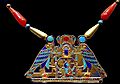
Within the pyramid complex multiple tombs were discovered by Petrie during his excavations. Those buried here were most likely family based on the names found in the tombs and the grave goods.[10] One tomb with a large quantity of grave goods is that of princess Sithathor-yunit, the daughter of the Senwosret II. Artifacts found were a crown, pectorals, bracelets, necklaces, and cowries.[11]
- Sithathor-yunet Jewelry
-
 Pectoral of Sithathor-yunet, reign of Senwosret II. Metropolitan Museum of Art.
 -
 Crown of Sithathor-yunet
 -
 Pectoral of Senusret II
 -
 Cowrie Shell Girdle, Lion Bracelets, Bracelets with the Name of Amenemhat III, and Anklets of Princess Sithathoryunet

.jpg)


Cemeteries
[edit]There have been many cemeteries found between the pyramid and the town. There appears to be a mixture of elite burials and pit burials depending on the cemetery. In the Bashkatib cemetery, there have been multiple types of burials found: open graves, shallow shaft tombs, stairway tombs, and deep shaft tombs.[12] Abdel Rahman el-Aydi found four cemeteries with an Egyptian mission. They mostly date to the Middle Kingdom like the rest of the site,[13] but there have been ones that date to the Roman period.[14]
Valley Temple
[edit]The Valley temple at Lahun is located slightly southwest of the town. The temple was most likely used for the royal mortuary cult of Senswosret II. It no longer exists as it lays under modern day cultivation. Originally, it would have been connected to the pyramid, but there is no evidence of a causeway connecting the two areas.[15] There have also been papyri found associated with the temple and the mortuary cult and even a day-book where "letters to and from the mayor were copied".[16] Other papyri at the temple included information about the cult of Anubis that was inside the temple and correspondence between the mayor and temple accountant. These recorded the inventory of the temple and what goods were required for it to operate.[17]
Town layout
[edit]
The village of el Lahun, also known as Kahun, is believed to have been inhabited by the workers who both constructed the pyramid and then served the funerary cult of the king. The main function "has usually been linked to the funerary cult of Senwosret II – whose nearby pyramid complex has been understood as the main reason for its existence – housing administrators, as well as temple staff for the upkeep of his royal mortuary cult."[18] The village is about 1.1 km from the pyramid and lies in the desert a short distance from the edge of cultivation.[13] The town was orthogonally planned, with mudbrick town walls on three sides. The fourth wall may have collapsed and been washed away during the annual inundation or covered due to the cultivation in the area.[19] The town was rectangular in shape and was divided internally by a mudbrick wall running north to south that was added after the initial eastern part of the town was built.[20] This wall divided about one third of the area of the town and created a western section with rows of back-to-back, side-by-side single room houses.[21] The eastern section of the town contains mansions, medium sized houses, and small houses similar to the ones in the western section. The mansions are located in the north part of the eastern section and there are seven in total with four along the northern wall and the other three across the street. The medium and small houses are located east and south of the mansions in the eastern section.[22]
Houses
[edit]In Kahun there are three main types of houses found: mansions, medium size houses, and smaller homes. The mansions are about 2,700 m2, medium are 100-168 m2, and small houses are 50 m2 or smaller. The small and medium houses are in the western section, and south and east of the mansions. The houses located in the western section are smaller and much closer together than ones south and east of the mansions.[22]
Multiple artifacts have been found in these houses. In the smaller houses papyri and copper tools have been found which can tell us a little about what the people who lived here did.[22]
Mansions and acropolis
[edit]Mansions were significantly larger than the other houses that most of the workers and villagers lived in. Mansions also contained granaries on one side of the building that could hold enough grain for the entire town.[23] They are located on the north edge of the town next to the northern wall.[22] These mansions were also separated into smaller units within that may have housed the entire family, the staff, and administrative activities.[24] There are also administrative sections in the mansions that contained seals and a few papyri detailing administrative duties and dealings as well as names of individuals.[16]
A major feature of the town was the so-called "acropolis" building. The acropolis is roughly the same size as the other mansions at Lahun and is located at the end of the main street to the west. It is next to the four mansions on the north side. It was most likely made for the mayor based on the seals and seal impressions found.[25] The platform the mudbrick building was built on was carved out of stone that already existed; it was only carved down to create the platform. It rests above the rest of the town on this platform.[15]
Discoveries
[edit]Papyri and Seals
[edit]
The papyri have been found in multiple areas of Lahun and are on different topics: administrative dealings, the town, and the temple. They had to do with agriculture, temple proceedings, and town organization.[15] Temple documents discuss the daily occurrences at the temple and important information about the temple. There were also census lists that listed the people who lived in the town including soldiers, servants, scribes, and members of certain households. Among the administrative papyri there were legal proceedings recorded including ones on debt.[26] Petrie was the first to propose that the seals and papyri found in the town of Kahun were for administrative purposes which was later supported by other finds including those in 1899 by Ludwig Borchardt.[27]
Many of these papyri also tell stories that were religious or literary. There were ones about the gods and their myths and tales that were found in other sites.[28] Also, papyri dealing with the chronology of the Ancient Egyptian world have been found called Sothic cycle.[29] The papyrus containing the Sothic date was found by Petrie and has narrowed Lahun's establishment to a fifty year timespan during the 12th Dynasty.[30] The papyrus says that it is "Month 8 Day 16 of a Year 7".[31] This date is one of the most definitive dates relating to Ancient Egypt. Knowing this date has allowed Egyptologists to organize the Middle Kingdom around Year 7 of Senwosret III's reign.[31] With other archaeological information from Lahun and other sites they are better able to determine the chronology of Egypt.[32]
The seals were found in some buildings in the town. They were attached to "boxes, vases, and bags" and marked what they contained.[33] They have the names of the people who owned the seals, or inscriptions to someone the object the seal was on was going to. The seals state who the person was and what their title was including high priest, citizen, or inspector.[34] The town was not the only place seals were found. Some were discovered by Petrie in the pyramid, precincts, and other areas during excavations. These ones also had the names of the people and their titles on them.[35]
Objects of daily life
[edit]Other objects of daily life have been found in the town and in the pyramid complex. These include copper tools found in what is believed to be the western workmen's section, flint tools, and pottery which is both local and foreign.[36] The pottery would have included bowls, storage jars, water jars, plates, and other tableware.[37] Cosmetic jars have been found in houses and the most common ones found have been kohl jars.[38] Jewelry has been found in the town and inside tombs that could have been potentially used by the owners in their daily lives or important objects that they waned in their afterlife.[39]
-
 Spouted jar, brown smooth pottery. From a box containing infant burial, with a lock of hair, shell, slip of wood, and beads. 12th Dynasty. From Lahun (Kahun), Faiyum, Egypt. Petrie Museum, London
 -
 Dried date, peach, apricot, and stones. From Lahun, Fayum, Egypt. Late Middle Kingdom. Petrie Museum, London
 -
 A bag of white linen, unopened. Contains rolls of linen only. Foundation deposit, Heb Sed Chapel at Lahun, Fayum, Egypt. 12th Dynasty. Petrie Museum, London
,_Faiyum,_Egypt._The_Petrie_Museum_of_Egyptian_Archaeology,_London.jpg)


Mummies
[edit]
In 2009, dozens of pharaonic-era mummies were uncovered near the pyramid of Senwosret II by Abdel Rahman El-Aydi and his team. The sarcophagi were decorated with green, red and white and an image of the person laid to rest there. Archaeologists unearthed multiple well preserved mummies which range from the 12th Dynasty to the 18th Dynasty.[40] Many have prayers inscribed on them with later mummies having texts from the Book of the Dead inscribed on them.[41] Some mummies even contain almost all of the funerary equipment from when the person first died. Multiple mummies also had Egyptian gods depicted on their sarcophagus, like Horus.[40]
See also
[edit]- List of ancient Egyptian sites, including sites of temples
Bibliography
[edit]- G. Brunton: Lahun I: The Treasure (BSAE 27 en ERA 20 (1914)), London 1920.
- A.R. David: The Pyramid Builders of Ancient Egypt: A Modern Investigation of Pharaoh’s Workforce, London, Boston en Henley 1986.
- B. Gunn: The Name of the Pyramid-Town of Sesostris II, in JEA 31 (1945), p. 106-107.
- B. J. Kemp: Ancient Egypt: Anatomy of a Civilization, London 1989.
- N. Moeller: The Archaeology of Urbanism in Ancient Egypt, Cambridge, England: University of Cambridge Press 2016.
- W.M.F. Petrie, G. Brunton, M. A. Murray: Lahun II (BSAE 33 en ERA 26 (1920)), London 1923.
- W.M.F. Petrie, F. Ll. Griffith, P.E. Newberry: Kahun, Gurob, and Hawara, London 1890.
- W.M.F. Petrie: Illahun, Kahun, and Gurob, London 1891.
- S. Quirke: (ed.), Lahun Studies, New Malden 1998.
- S. Quirke: Lahun: A Town in Egypt 1800 BC, and the History of Its Landscape, London 2005.
- A. Scharff: Illahun und die mit Königsnamen des Mittleren Reiches gebildeten Ortsnamen, in ZÄS 59 (1924), p. 51-55.
- K. Szpakowska: Daily Life in Ancient Egypt: Recreating Lahun, Malden, Oxford, Carlton 2008 ISBN 978-1-4051-1856-9
- H. E. Winlock: The Treasure of el Lahun, New York 1973.
References
[edit]- ^ Peust, Carsten. "Die Toponyme vorarabischen Ursprungs im modernen Ägypten" (PDF). p. 57.
- ^ Moeller, Nadine (2018). The archaeology of urbanism in ancient Egypt: from the predynastic period to the end of the Middle Kingdom. Cambridge: Cambridge University Press. p. 271. ISBN 978-1-107-43908-5.
- ^ a b Petrie, W. M. Flinders (1891). Illahun, Kahun, and Gurob (published 1974).
- ^ Borchardt, Ludwig (1899). "Der zweite Papyrusfund von Kahn und die zeitliche Festlegung des mittleren Reiches des ägyptischen Geschichte". Zeitschrift für Ägyptische Sprache und Altertumskunde. 37: 89–103.
- ^ Frey, Rosa A.; Knudstad, James E. (2008). "The Re-examination of Selected Architectural Remains at El-Lahun". Journal of the Society of the Studies of Egyptian Archaeology. 35: 27–81.
{{cite journal}}: CS1 maint: multiple names: authors list (link) - ^ Horvath, Zoltan (2009). "El-Lahun Survey Project: The Archaeological Mission of the Museum of Fine Arts". Bulletin du Musée Hongrois des Beaux-Arts: 186–190 – via Academia.
- ^ Johnson, C. Cache of mummies unearthed at Egypt's Lahun pyramid. April 26, 2009.
- ^ a b Petrie, W. M. Flinders (1891). Illahun, Kahun, and Gurob (published 1974). p. 1.
- ^ Petrie, W. M. Flinders (1891). Illahun, Kahun, and Gurob (published 1974). p. 5.
- ^ Brunton, Guy (1920). Lahun I: The Treasure. London: Bernard Quartich. p. 43.
- ^ Brunton, Guy (1920). Lahun I: The Treasure. London: Bernard Quartich. p. 42.
- ^ Petrie, W. M. Flinders; Brunton, Guy; Murray, M.A. (1923). Lahun II. London: Bernard Quartich. pp. 21–23.
- ^ a b Moeller, Nadine (2018). The archaeology of urbanism in ancient Egypt: from the predynastic period to the end of the Middle Kingdom. Cambridge: Cambridge University Press. p. 272. ISBN 978-1-107-43908-5.
- ^ Petrie, W. M. Flinders; Brunton, Guy; Murray, M.A. (1923). Lahun II. London: Bernard Quartich. p. 24.
- ^ a b c Kemp, Barry (2018). Ancient Egypt: Anatomy of a Civilization (3rd ed.). Routledge. p. 213.
- ^ a b Kemp, Barry (2018). Ancient Egypt: Anatomy of a Civilization (3rd ed.). Routledge. pp. 218–219.
- ^ Quirke, Stephen (2005). Lahun: a town in Egypt 1800 BC, and the history of its landscape. Egyptian Sites. London: Golden House Publications. pp. 30–36. ISBN 978-0-9550256-1-7.
- ^ Nadine Moeller, The Foundation and Purpose of the Settlement at Lahun during the Middle Kingdom: A New Evaluation in R.K. Ritner (ed.), Essays for the Library of Seshat. Studies Presented to Janet H. Johnson on the occasion of her 70th birthday, SOAC 70, Chicago: The Oriental Institute, (2018), p.187.
- ^ Moeller, Nadine (2018). The archaeology of urbanism in ancient Egypt: from the predynastic period to the end of the Middle Kingdom. Cambridge: Cambridge University Press. p. 335. ISBN 978-1-107-43908-5.
- ^ Moeller, Nadine (2018). The archaeology of urbanism in ancient Egypt: from the predynastic period to the end of the Middle Kingdom. Cambridge: Cambridge University Press. p. 276. ISBN 978-1-107-43908-5.
- ^ "A Planned Town of the Middle Kingdom: Kahun." Arts and Humanities Through the Eras. Gale. 2005. "Archived copy". Archived from the original on 2016-04-13. Retrieved 2019-08-05.
{{cite web}}: CS1 maint: archived copy as title (link) - ^ a b c d Moeller, Nadine (2018). The archaeology of urbanism in ancient Egypt: from the predynastic period to the end of the Middle Kingdom. Cambridge: Cambridge University Press. pp. 286–287. ISBN 978-1-107-43908-5.
- ^ Moeller, Nadine (2018). The archaeology of urbanism in ancient Egypt: from the predynastic period to the end of the Middle Kingdom. Cambridge: Cambridge University Press. p. 285. ISBN 978-1-107-43908-5.
- ^ Moeller, Nadine (2018). The archaeology of urbanism in ancient Egypt: from the predynastic period to the end of the Middle Kingdom. Cambridge: Cambridge University Press. p. 367. ISBN 978-1-107-43908-5.
- ^ Moeller, Nadine (2018). The archaeology of urbanism in ancient Egypt: from the predynastic period to the end of the Middle Kingdom. Cambridge: Cambridge University Press. p. 278. ISBN 978-1-107-43908-5.
- ^ Kemp, Barry. Ancient Egypt: Anatomy of a Civilization (3rd ed.). Routledge. pp. 218–220.
- ^ Moeller, Nadine (2018). The archaeology of urbanism in ancient Egypt: from the predynastic period to the end of the Middle Kingdom. Cambridge: Cambridge University Press. p. 283. ISBN 978-1-107-43908-5.
- ^ Quirke, Stephen (2005). Lahun: a town in Egypt 1800 BC, and the history of its landscape. Egyptian Sites. London: Golden House Publications. pp. 106–108, 111–112. ISBN 978-0-9550256-1-7.
- ^ Depuydt, Leo (2000). "Sothic Chronology and the Old Kingdom". Journal of the American Research Center in Egypt. 37: 167–186. doi:10.2307/40000529. ISSN 0065-9991. JSTOR 40000529.
- ^ Depuydt, Leo (2000). "Sothic Chronology and the Old Kingdom". Journal of the American Research Center in Egypt. 37: 171. doi:10.2307/40000529. ISSN 0065-9991. JSTOR 40000529.
- ^ a b Depuydt, Leo (2000). "Sothic Chronology and the Old Kingdom". Journal of the American Research Center in Egypt. 37: 172. doi:10.2307/40000529. ISSN 0065-9991. JSTOR 40000529.
- ^ Depuydt, Leo (2000). "Sothic Chronology and the Old Kingdom". Journal of the American Research Center in Egypt. 37: 167–186. doi:10.2307/40000529. ISSN 0065-9991. JSTOR 40000529.
- ^ Petrie, W. M. Flinders (1891). Illahun, Kahun, and Gurob. London (published 1974). p. 14.
{{cite book}}: CS1 maint: location missing publisher (link) - ^ Petrie, W. M. Flinders; Brunton, Guy; Murray, M. A. (1923). Lahun II. London: Bernard Quartich. p. 41.
- ^ Petrie, W. M. Flinders; Brunton, Guy; Murray, M. A. (1923). Lahun II. London: Bernard Quartich.
- ^ Petrie, W. M. Flinders (1891). Illahun, Kahun, and Gurob. London (published 1974). pp. 8–15.
{{cite book}}: CS1 maint: location missing publisher (link) - ^ Szpakowska, Kasia Maria (2008). Daily life in ancient Egypt: recreating Lahun. Malden, MA: Blackwell Pub. p. 93. ISBN 978-1-4051-1855-2. OCLC 167763916.
- ^ Szpakowska, Kasia Maria (2008). Daily life in ancient Egypt: recreating Lahun. Malden, MA: Blackwell Pub. pp. 65–66. ISBN 978-1-4051-1855-2. OCLC 167763916.
- ^ Szpakowska, Kasia (2008). Daily life in ancient Egypt: recreating Lahun. Malden (Mass.): Blackwell Publishing. pp. 76–78. ISBN 978-1-4051-1855-2.
- ^ a b [1] Archived 2020-10-22 at the Wayback Machine
- ^ redOrbit (2009-04-27). "New Cache Of Mummies Discovered In Egypt - Redorbit". Redorbit. Retrieved 2018-02-26.
External links
[edit]![]() Media related to El-Lahun at Wikimedia Commons
Media related to El-Lahun at Wikimedia Commons
| International | |
|---|---|
| National | |
| Geographic | |
| Other | |
El Lahun
View on GrokipediaHistorical Context
Location and Geography
El Lahun is situated in the Faiyum Oasis region of Egypt, approximately 100 kilometers southwest of Cairo, at the entrance to the Faiyum depression where the Bahr Yussef canal diverges from the Nile Valley.[7] The site's coordinates are approximately 29°14′N 30°58′E, placing it at the desert edge north of the modern village of El Lahun.[8] Geologically, El Lahun occupies an artificial terrace constructed from lacustrine clay deposits, elevated to mitigate seasonal flooding risks from the nearby Lake Moeris, now known as Birket Qarun.[9] This terrace, carved from the sloping ground at the oasis's margin, provided a stable foundation amid the surrounding alluvial and lacustrine sediments characteristic of the Faiyum basin.[10] The location's strategic proximity to the Nile Valley facilitated its role in ancient hydraulic engineering, particularly under Pharaoh Senusret II of the Twelfth Dynasty, who initiated irrigation enhancements by constructing a dike at El Lahun to regulate water flow from the Bahr Yussef into the Faiyum, supporting agricultural expansion around Lake Moeris.[11] This positioning at the "mouth" of the canal system underscored the site's importance for controlling water distribution in the oasis.[12] In antiquity, the site bore the Egyptian name rꜣ-ḥn.t, interpreted as "Mouth of the Canal," reflecting its hydrological significance.[13] During the Ptolemaic period, it was redesignated Ptolemais Hormos, denoting a harbor associated with Ptolemaic infrastructure.[14]Middle Kingdom Foundations
The Middle Kingdom, approximately 2055 to 1650 BCE, represented a phase of political reunification and cultural renaissance in ancient Egypt after the fragmentation of the First Intermediate Period. The 12th Dynasty (c. 1991–1802 BCE) epitomized this stability through centralized royal authority, administrative reforms, and economic prosperity, enabling territorial expansion into Nubia and the eastern deserts while fostering internal development via monumental architecture and resource management. Pharaohs of this dynasty prioritized agricultural enhancement and trade, laying the groundwork for enduring state infrastructure that supported population growth and elite patronage of arts and literature.[15] Senusret II, the fourth ruler of the 12th Dynasty, reigned from c. 1897 to 1878 BCE, ascending during a co-regency with his father, Amenemhat II, which ensured smooth dynastic transition. As part of a lineage that had solidified pharaonic control since the dynasty's founding, Senusret II's family included prominent queens like Khenemetneferhedjet I and Nofret II, and he elevated his son Amenemhat III to co-regent toward the end of his reign, with the duration debated but likely brief (c. 2-6 years), promoting continuity in governance. His rule emphasized peaceful internal consolidation over external conquests, with a particular focus on the Faiyum Oasis, where he spearheaded early hydrological initiatives to expand cultivable land and bolster food security amid growing demands.[16] El Lahun was founded as Senusret II's royal pyramid complex, strategically positioned to integrate mortuary functions with the Faiyum's agricultural potential. The site's establishment aligned with broader 12th Dynasty efforts to reclaim arid lands through engineered canals—such as precursors to the Bahr Yussef—and basin systems that regulated Nile inundations into Lake Moeris, transforming the depression into a vital granary that enhanced Egypt's economic resilience. This dual purpose not only perpetuated the pharaoh's cult but also facilitated labor mobilization for regional irrigation, underscoring the intertwining of royal ideology and practical resource exploitation.[17] Occupation at El Lahun peaked during the 12th Dynasty, with intensive activity tied to pyramid construction, cult maintenance, and associated administrative operations from c. 1897 BCE onward. Use persisted into the 13th Dynasty (c. 1802–1649 BCE), albeit with reduced scale and shifts toward more localized functions, reflecting the dynasty's waning central control. Secondary phases occurred in the New Kingdom, notably the 18th Dynasty (c. 1550–1295 BCE), involving sporadic reoccupation and ritual reuse, though the site largely declined as a primary center thereafter.[18]Site Layout and Architecture
Pyramid Complex
The pyramid complex at El Lahun, constructed for Pharaoh Senusret II during the Twelfth Dynasty (c. 1897–1878 BCE), represents a key example of Middle Kingdom monumental architecture, emphasizing innovation in material use and security features amid the Faiyum region's challenging terrain. The central pyramid, known anciently as Senusret Kha ("Senusret Shines"), was built primarily of mudbrick for its superstructure, supported by a core of limestone walls infilled with mudbrick to enhance stability, and originally encased in polished white limestone that has largely eroded away.[19][20] Its base measured 106 meters per side at ground level, with an original height of 48.6 meters and a slope angle of approximately 42°35', making it one of the earliest large-scale mudbrick pyramids in Egypt.[21] The structure was erected on an artificial terrace cut from a natural limestone hill about 12 meters high, which served to elevate the foundation and mitigate issues from the area's high groundwater levels near the Faiyum Oasis.[22] A distinctive feature of the pyramid is its southern entrance, an unconventional placement likely intended to enhance security by deviating from the typical north-facing orientation and disguising access as part of a subsidiary burial.[20] This entrance leads to a descending corridor with bends that reaches the burial chamber, incorporating antechambers and a portcullis system of granite slabs to block intruders. The burial chamber itself, located deep underground, features a vaulted ceiling lined with red granite and houses a finely crafted pink granite sarcophagus positioned against the west wall; the chamber was found looted upon discovery.[20] The complex includes associated royal burials integrated into its layout, such as a smaller subsidiary pyramid on the north side attributed to Senusret II's queen, Atmuneferu, designed in similar mudbrick style but on a reduced scale.[23] Flanking the main pyramid to the north are a series of mastaba tombs for royal family members, including princesses and officials, carved partly into the bedrock and aligned parallel to the enclosure wall, reflecting the hierarchical organization of the necropolis.[20] These elements, enclosed within a mudbrick perimeter wall, underscore the pyramid's role as the focal point of a broader funerary landscape, briefly referencing its position at the Faiyum's entrance for ritual and agricultural significance.[22]Valley Temple and Cemeteries
The Valley Temple at El Lahun is situated in the cultivated plain southwest of the adjacent town of Kahun, serving as the lower component of Senusret II's pyramid complex during the Middle Kingdom's Twelfth Dynasty.[24] Constructed primarily of mudbrick with incorporated stone elements such as red granite lintels and jambs inscribed in green hieroglyphs, the temple facilitated the pharaoh's mortuary cult through rituals honoring his ka (spirit).[24] Its square layout, approximately 125 feet wide with a northern annexe extending 17 feet, featured rock-cut foundations and brick pavements preserved under layers of marl chips up to 7 feet deep; however, much of the structure has been eroded or destroyed by modern agricultural activity, leaving only scattered fragments like a king's head relief now in the Cairo Museum and foundation deposits containing pottery saucers, model bricks, and inscribed sealings.[24] These deposits, unearthed at the southeast corner and central axis during William Flinders Petrie's 1920 excavations, underscore the temple's dedication to Senusret II, whose cartouche "Ra-kha-kheper" appears on associated artifacts.[24] A causeway connected the Valley Temple to the pyramid temple atop the desert plateau, approximately three-quarters of a mile to the west, forming a ritual processional route for festivals and offerings central to the pharaonic mortuary practices.[24] This sloping brick roadway, built over underlying rock-cut tomb pits, measured about 85 feet in its preserved foundation sections with side walls spaced 80 inches apart and small slab paving; though heavily ruined, it included an offering area evidenced by small pottery vessels (types 5 D and 6 W) and limestone lamps discovered along its path.[24] The causeway's alignment emphasized the spiritual axis linking the fertile valley to the pyramid, the focal point of the royal funerary landscape, without extensive physical elaboration beyond its functional brick construction.[24][25] The cemeteries at El Lahun, positioned between the pyramid and the town, encompass a range of burial sites spanning the Middle Kingdom to the Roman period, with elite mastaba tombs and simpler pit graves reflecting hierarchical social structures.[24] The Pyramid Cemetery, adjacent to the royal monument, features larger mastabas for nobles and royalty, such as Tomb 621—a deep shaft with a granite sarcophagus likely intended for a queen—and Tombs 7 through 10 for princesses like Sat-Hathor-ant, containing wooden coffins, alabaster jars with inscriptions, and grave goods including carnelian and jasper beads, glazed pottery (types 2 Ma and 5 H), and a wooden canopic box.[24] Further southwest lies the Bashkatib Cemetery, with over 104 graves including open pits, shallow shafts, and deep portcullis-sealed tombs from the Old Kingdom's First to Third Dynasties, but reused in the Middle Kingdom for contracted burials accompanied by hammerstones, syenite fragments, and pottery (type 67 Xₓ).[24] On the west ridge, mastabas like that of the official Anpy include multi-chambered underground structures, though often found empty of remains due to ancient looting, with artifacts such as boat models and stone vases indicating status.[24] Evidence of later reuse appears in Eighteenth Dynasty graves near the Valley Temple, featuring multiple interments in shared coffins and glass beads, extending the site's necropolis function across millennia.[24]Town of Kahun
The town of Kahun, the primary workers' settlement at El Lahun, lies approximately 1.1 kilometers northeast of Senwosret II's pyramid complex, positioned on the edge of the desert near the cultivation zone in the Fayum region. Enclosed by substantial mudbrick walls reaching up to 6 meters in height, the settlement spans about 14 hectares and follows a rigidly planned orthogonal grid layout, with straight streets intersecting at right angles to form organized blocks. This design exemplifies Middle Kingdom urban planning, dividing the town into eastern and western sections separated by an internal north-south wall, reflecting administrative control over the population.[26][27][18] The layout underscores a clear social hierarchy, with an elevated acropolis in the eastern section likely serving as the residence for high-ranking officials, such as a nomarch or senior administrator overseeing the pyramid project. Adjacent to this, more than 25 large mansions, some exceeding 2,700 square meters, featured expansive courtyards, columned porticos, and private granaries, accommodating elite families, their retainers, and administrative staff. These structures, concentrated in the higher-status eastern zone, contrast sharply with the denser western area, highlighting stratified organization within the community.[27][25] Housing varied by status and function, including medium-sized multi-room dwellings of 100 to 168 square meters for mid-level supervisors, equipped with multiple chambers around central spaces, and smaller workers' homes of 50 square meters or less, consisting of basic single- or two-room layouts with minimal amenities. Evidence of craft workshops, such as areas for tool-making and textile production, appears integrated into residential blocks, particularly in the western section, supporting the settlement's self-sufficiency.[26][28] Infrastructure included a network of paved and unpaved streets, rudimentary drainage channels along alleys to manage wastewater, and controlled access via gates, such as the main eastern entrance with its approach passage. Built to temporarily house the pyramid's construction workforce and later support the royal mortuary cult, the town was largely abandoned upon completion of the project around the late 19th century BCE, with many structures dismantled for materials.[27][26]Excavation History
Early Discoveries (1889–1920)
The archaeological exploration of El Lahun began in the late 19th century, marking one of the earliest systematic investigations of a Middle Kingdom site in Egypt. In 1889–1890, British Egyptologist William Flinders Petrie initiated excavations at the pyramid complex and the adjacent town of Kahun (modern-day Illahun), focusing on the mudbrick structures that had remarkably preserved the site's layout despite erosion over millennia. Petrie mapped the town's grid-like streets and residential quarters, revealing a planned workers' settlement associated with the pyramid's construction under Senusret II. During this campaign, he excavated the pyramid's south entrance, uncovering evidence of ancient looting in the burial chamber, where the sarcophagus had been ransacked. Administrative papyri were recovered from debris in the adjacent town of Kahun. Petrie's work highlighted the site's potential for insights into daily life, though his methods relied on manual labor without stratigraphic controls, leading to some finds being dispersed to institutions like the Petrie Museum at UCL. In 1913–1914, Petrie returned to El Lahun with Guy Brunton, conducting excavations in the pyramid complex and surrounding areas, including subsidiary tombs south of the pyramid. This campaign uncovered significant burial remains associated with royal family members, contributing to the understanding of Middle Kingdom funerary practices.[29] Petrie returned briefly in 1920 to further document the pyramid's architecture and town remnants, noting the exceptional preservation of mudbrick walls up to several meters high in places, which allowed for detailed plans of over 200 houses and administrative buildings. His efforts established El Lahun as a key site for understanding Middle Kingdom urban planning, with sketches and photographs capturing the layout before further degradation. In 1899, German archaeologist Ludwig Borchardt conducted a targeted excavation at the town of Kahun, emphasizing architectural documentation and stratigraphic analysis to contextualize the site's phases of occupation. Borchardt recovered numerous papyrus fragments from the debris of collapsed buildings and the antiquities market, many bearing administrative and mathematical texts, which he meticulously cataloged before their transfer to the Egyptian Museum in Cairo and the Louvre. His approach, which involved careful layer-by-layer removal, provided early evidence of the site's multi-phase use from the 12th Dynasty onward, though limited funding and rudimentary preservation techniques resulted in some artifacts deteriorating en route to museums. These pioneering efforts by Petrie and Borchardt laid the groundwork for later archaeology but underscored the challenges of early 20th-century fieldwork, including the irreversible dispersal of artifacts across global collections.Modern and Ongoing Excavations
Following the exploratory work of Flinders Petrie in the late 19th century, modern excavations at El Lahun began in earnest with the concession granted to Nicholas B. Millet of the University of Toronto and the Royal Ontario Museum from 1989 to 1997.[26] Millet's team conducted a systematic survey of the town and adjacent cemeteries, documenting architectural remains and stratigraphic layers to better understand site preservation.[27] Their analysis of housing layouts revealed patterns of social stratification, with larger elite residences clustered in the northern sector contrasting with denser, smaller worker dwellings in the south, indicating hierarchical organization within the Middle Kingdom settlement.[26] In 2009, a team from the Supreme Council of Antiquities (now the Ministry of Tourism and Antiquities) re-excavated areas near the pyramid base, uncovering a cache of over 30 mummies in brightly painted wooden coffins dating from the 12th to 18th Dynasties.[30] This discovery highlighted the site's prolonged use as a burial ground beyond the Middle Kingdom, with the mummies interred in simple shaft tombs amid sand dunes.[31] The effort addressed gaps left by earlier digs, focusing on conservation to protect the vulnerable remains from environmental degradation. Since the early 2000s, the Hungarian Archaeological Mission, led by Zoltán Horváth of the Museum of Fine Arts in Budapest, has undertaken the El-Lahun Survey Project as an ongoing initiative.[32] The project employs non-invasive geophysical surveys, including ground-penetrating radar and magnetic mapping, to identify unexcavated structures in the town and peripheral zones without disturbing the site.[33] Emphasis has been placed on re-excavating select areas of the town to refine Petrie's original plans, alongside conservation measures to stabilize mudbrick architecture against erosion and modern threats. Post-2010 advancements have integrated satellite imagery with ground-based data to map subsurface features at El Lahun, revealing previously undetected alignments of walls and potential tomb shafts.[25] These remote sensing techniques, applied in surveys around the pyramid and town, aid in delineating site boundaries and monitoring changes over time.[34] No major new discoveries have been reported since 2020, though ongoing geophysical work by Egyptian and international teams continues to counter looting activities, which have intensified in the region due to political instability.[35]Key Discoveries
Papyri and Administrative Records
The Kahun Papyri, comprising approximately 1,000 fragments, were unearthed from rubbish heaps within the ancient town of Kahun at El Lahun, providing a rare glimpse into Middle Kingdom administrative practices.[36] These documents, dating primarily to Year 7 of Senusret III around 1870 BCE, include a diverse array of texts that illuminate the bureaucratic operations of the pyramid workforce and local governance. The papyri were primarily discovered by Flinders Petrie during his 1888–1889 excavations, with additional fragments recovered by Ludwig Borchardt in 1899–1900.[37] The contents of the Kahun Papyri encompass legal contracts, such as those detailing adoptions and marriages, which reveal the social and familial structures supporting the pyramid town's community.[36] Medical treatises form another significant category, including veterinary texts addressing cattle ailments and gynecological works outlining treatments for women's health issues like infertility and contraception.[38] Mathematical problems appear in fragments that demonstrate practical calculations for resource allocation, while religious hymns dedicated to deities and the king highlight the spiritual dimensions of daily administration.[36] These texts collectively underscore a sophisticated system of record-keeping that managed labor, supplies, and interpersonal relations in the pyramid complex.[37] Among the most notable documents is the Sothic Cycle Papyrus, a fragmentary record from the same period that notes the heliacal rising of Sirius (Sothis) in Year 7 of Senusret III. This astronomical observation serves as a critical dating tool, anchoring the Middle Kingdom chronology by aligning the Egyptian civil calendar with stellar events and confirming the reign's temporal framework through subsequent Sothic cycle calculations. Administrative seals found at El Lahun further attest to the hierarchical organization of the pyramid town, known anciently as Hotep-Senusret. Cylinder and scarab seals impressed on storage jars bear official titles, such as "overseer of the pyramid town," indicating roles in supervising construction, provisioning, and temple activities. These artifacts, often linked to viziers' bureaus, reflect a centralized authority structure that coordinated the site's economic and logistical functions.Artifacts of Daily Life
Excavations at the town of Kahun, associated with the El Lahun pyramid complex, have yielded a rich assemblage of utilitarian artifacts that illuminate the daily activities of its Middle Kingdom inhabitants, primarily workers and their families. These objects, recovered from mud-brick house debris and domestic contexts, include tools for craftsmanship and agriculture, pottery for storage and cooking, personal adornment items, and household implements reflecting food preparation and diet. Such finds, documented during William Matthew Flinders Petrie's campaigns in 1888–1890 and 1913–1914, provide evidence of on-site production and trade networks supporting the pyramid workforce.[4] Tools and implements discovered in residential areas highlight the practical demands of construction, farming, and textile work. Copper chisels, knives, and piercers, alongside flint knives for cutting and scraping, were essential for woodworking and stoneworking tasks. Wooden hoes, rakes, and mallets facilitated agriculture in the nearby Faiyum region, while weaving-related items such as spindles, thread balls, and loom weights indicate linen production within households. A wooden cubit rod, used for precise measurements, underscores the organized labor in the settlement. Evidence of craft production is evident from these tools' distribution in workmen's quarters.[24][39][40][4] Pottery and vessels formed the backbone of domestic storage and consumption, with local Nile silt jars for grain and water alongside finer marl clay bowls for serving. Imported Canaanite amphorae, identified among the assemblages, point to trade connections with the Levant for oils and resins, integrating Kahun into broader Mediterranean exchange. These ceramics, often found in house fills, vary in form from everyday cooking pots to specialized storage jars, reflecting both utilitarian needs and status differences among residents.[24][41] Personal items recovered from domestic settings reveal attention to grooming and adornment among the town's populace. Kohl tubes and pots of obsidian or alabaster held eye makeup, while copper or silver mirrors aided in application, often paired with tweezers and hair curlers for hygiene. Simple jewelry, including faience and shell beads strung into necklaces, supplemented rarer carnelian or turquoise examples, suggesting on-site crafting of affordable accessories. These artifacts, clustered in wealthier house sectors, indicate personal care practices across social strata.[4][29] Household goods attest to the routines of food processing and sustenance in Kahun's arid environment. Bread molds of clay and quartzite grinding stones were ubiquitous for milling grain into flour, essential for the staple diet. Animal bones scattered in debris, including those from cattle for meat and dairy, complemented fish remains from the Faiyum lakes, evidencing a protein-rich menu supported by local herding and fishing. Fishing nets and possible rat traps further illustrate pest control and resource management in daily life.[24][42][4]Funerary Remains and Mummies
In 1889, British archaeologist William Flinders Petrie discovered fragments of a royal sarcophagus within the pyramid complex at El Lahun, indicating an elite burial of the 12th Dynasty pharaoh Senusret II, though the tomb had been robbed in antiquity.[29] Petrie also uncovered several child mummies in the surrounding cemeteries, preserved in small wooden coffins and exhibiting natural desiccation typical of the arid environment.[24] A major discovery occurred in 2009 when Egyptian archaeologist Abdel Rahman el-Ayedi's team unearthed a cache of over 30 mummies near the pyramid, dating primarily from the 12th to 18th Dynasties and including both males and females aged approximately 18 to 60 years.[43][30] These individuals were wrapped in linen inscribed with spells from the Book of the Dead, reflecting standard Middle Kingdom and later funerary practices aimed at ensuring safe passage to the afterlife.[43] The mummies were naturally preserved through the use of natron, a naturally occurring sodium salt that dehydrated the bodies and inhibited bacterial growth, a technique common in ancient Egyptian embalming from the Middle Kingdom onward.[44] Bioarchaeological analysis of examples from the cache, such as two female mummies dated to the Third Intermediate Period (though part of the broader assemblage), revealed evidence of health conditions including severe dental wear attributed to a coarse, abrasive diet rich in grit from stone-ground grains, as well as arthritis-like degenerative changes such as scoliosis and osteopenia.[45] Associated grave goods included amulets for magical protection, canopic jars for organ storage, and wooden coffins often made from local sycamore or imported woods like Aleppo pine, contrasting with the more elaborate stone sarcophagi and granite elements found in the elite pyramid burials.[45][30] These non-royal interments highlight variations in burial customs based on social status, with simpler yet functional elements emphasizing communal rather than individualized elite commemoration.[29] Notable funerary treasures from the site include jewelry caches discovered in 1914 by Flinders Petrie and Guy Brunton in subsidiary tombs south of the pyramid, belonging to Princess Sithathoryunet, daughter of Senusret II. These included gold pectorals, necklaces, girdles, and amulets inscribed with the names of Senusret II and his successor Amenemhat III. The artifacts, now in collections such as the Metropolitan Museum of Art, exemplify Middle Kingdom royal burial practices and artistic craftsmanship.[6]Significance
Insights into Middle Kingdom Society
The planned layout of El Lahun, divided into an eastern elite quarter known as Hetep with spacious residences up to 170 square meters and a western workers' quarter called Sekhem featuring uniform smaller houses of 44-62 square meters, separated by a substantial enclosure wall, exemplifies the rigid class divisions in Middle Kingdom society.[18] This spatial segregation enforced social hierarchy, with elites enjoying palatial estates and workers, including conscripts, prisoners, and foreign laborers, confined to controlled zones monitored by a "great prison" and restricted access points.[18] Gender roles emerge from administrative records showing women participating in legal proceedings, such as property disputes and substitutions for male labor obligations, as well as serving as temple musicians and dancers, often of Asiatic origin, highlighting their economic agency within a patriarchal framework.[46][18] Economically, El Lahun's development as a pyramid town underscores the state's mobilization of labor for monumental projects, with pyramid construction relying on seasonal corvée systems that conscripted thousands of ḥsbw (enlisted workers) and mnyw (counted laborers) for quarrying and transport, coordinated through central bureaucracies under the vizier.[46] This state-directed effort, involving temporary camps housing 1,200-1,500 workers and provisions from royal granaries, reinforced economic centralization and social cohesion under pharaonic authority.[46] Trade connections are evident in imported Levantine artifacts, such as pottery from Byblos, indicating exchange networks that supplied the settlement and integrated Egypt into broader regional economies during the Twelfth Dynasty.[47] Culturally, the site's dedication to Senusret II's mortuary cult reveals deep religious devotion, with the town serving as a center for priests to perform rituals sustaining the king's eternal life as Osiris and upholding maat (cosmic order).[48] The Kahun papyri provide evidence of advanced medical knowledge, particularly in gynecology and veterinary care, documenting treatments for women's reproductive health and animal ailments that reflect practical, empirical approaches to healing in daily life.[38] The town's abrupt decline and abandonment shortly after Senusret II's death, with layers of refuse indicating hasty departure and minimal reuse until later periods, points to rituals tied to the pharaoh's cult, where the settlement's purpose ended with the cessation of royal support.[48][49] As a paradigmatic Middle Kingdom site, El Lahun contrasts with Old Kingdom pyramid complexes, which emphasized solid limestone structures without such integrated, state-planned worker towns, highlighting the era's shift toward mud-brick cores, enhanced urbanism, and administrative oversight to sustain royal cults amid a more decentralized political landscape.[50] This model settlement illustrates the Twelfth Dynasty's emphasis on controlled colonization and social engineering, differing from the Old Kingdom's focus on elite necropolises by incorporating diverse populations in a functionally rigid community.[18][26]Recent Research and Interpretations
Since the early 2000s, the El-Lahun Survey Project, conducted by the Museum of Fine Arts in Budapest, has employed non-invasive methods including geophysical surveys to map unexcavated areas around the pyramid complex and associated town. These efforts, initiated in 2009, have identified potential subsurface features such as tombs and structural remains through magnetic gradiometry and ground-penetrating radar, revealing a more extensive necropolis than previously documented.[32][51] Integrated geophysical investigations in the 2020s have further highlighted buried archaeological ruins north of the Senusret II pyramid, including possible canal systems linked to ancient water management in the Faiyum region. A 2022 study using electrical resistivity tomography and magnetic surveys detected high-resistivity anomalies indicative of mudbrick structures and voids, suggesting unexcavated tombs and irrigation channels that supported the site's pyramid construction. Satellite imagery analysis has corroborated these findings by tracing extinct Nile branches, such as the Ahramat Branch, which likely facilitated material transport to El Lahun during the Middle Kingdom.[34][52][53] Recent debates center on the pyramid's apparent "floating" appearance, attributed in 2024-2025 discussions to optical illusions from groundwater levels or construction techniques involving elevated foundations, though these remain unconfirmed without further excavation. Studies from the 2010s, building on survey data, have reinterpreted the town of Kahun as a multi-phase settlement with distinct zones, including a potential "ghetto" area for lower-status or foreign workers, evidenced by varied architectural layouts and artifact distributions indicating prolonged occupation and social stratification.[54][55][18] Significant gaps persist in understanding the site's 13th Dynasty reuse, with limited archaeological data on how the settlement and pyramid were adapted during this period of political fragmentation, as seen in reused administrative papyri but lacking comprehensive stratigraphic evidence. Conservation challenges include ongoing threats from agricultural expansion in the Faiyum Oasis, which encroaches on the site, and looting incidents exacerbated by post-2011 instability, though no major excavations have been reported since 2020.[18][56][57] Future research directions emphasize potential DNA analysis of mummies, including those from 2009 discoveries, to explore kinship networks among the site's inhabitants and their connections to broader Middle Kingdom populations. Integration with regional Faiyum projects could further contextualize El Lahun's role in ancient hydraulic engineering and oasis development.[58][59]References
- https://en.wikinews.org/wiki/30_brightly_coloured_mummies_discovered_in_Egyptian_necropolis