Hubbry Logo
ByblosByblosMain
Open search
Byblos
Community hub
Byblos
logo
8 pages, 0 posts
0 subscribers
Be the first to start a discussion here.
Contribute something
Byblos
Byblos
from Wikipedia

Byblos (/ˈbɪblɒs/ BIB-loss; Ancient Greek: Βύβλος), also known as Jebeil, Jbeil or Jubayl (Arabic: جُبَيْل, romanizedJubayl, locally Jbeil [ʒ(ə)beːl]), is an ancient city in the Keserwan-Jbeil Governorate of Lebanon. The area is believed to have been first settled between 8800 and 7000 BC[1] and continuously inhabited since 5000 BC.[2] During its history, Byblos was part of numerous cultures including Egyptian, Phoenician, Assyrian, Persian, Hellenistic, Roman, Genoese, Mamluk and Ottoman. Urbanisation is thought to have begun during the third millennium BC when it developed into a city,[3][2] making it one of the oldest cities in the world, if not the oldest. It is a UNESCO World Heritage Site.[4]

Key Information

It was in Ancient Byblos that the Phoenician alphabet, the ancestor of the Greek, Latin and all other Western alphabets, was developed.[5]

Etymology

[edit]
R5
N35
Z4
N25
kbnj[6]
in hieroglyphs
Era: 1st Intermediate Period
(2181–2055 BC)
V31 D58 N35
N25
kbn[6][7]
in hieroglyphs
Era: Middle Kingdom
(2055–1650 BC)

The name appears as kbnj in Egyptian hieroglyphic records going back to the 4th-dynasty pharaoh Sneferu (fl. 2600 BC)[8] and as Gubla (𒁺𒆷) in the Akkadian cuneiform Amarna letters to the 18th-dynasty pharaohs Amenhotep III and IV. In the 1st millennium BC, its name appeared in Phoenician and Punic inscriptions as Gebal (𐤂𐤁𐤋, GBL);[9][10] in the Hebrew Bible as Geval (גבל);[11] and in Syriac as GBL (ܓܒܠ). Eusebius' Onomasticon stated that Byblos was called "Gobel / Gebal" in Hebrew.[12] The name seems to derive from GB (𐤂𐤁, "well") and ʾL (𐤀𐤋, "god"), the latter a word that could variously refer to any of the Canaanite gods or to their leader in particular. The name thus seems to have meant the "Well of the God" or "Source of the God".[citation needed]

Its present Arabic name Jubayl (جبيل) or J(e)beil is a direct descendant of these earlier names, although apparently modified by a misunderstanding of the name as the triliteral root GBL or JBL, meaning "mountain". When the Arabic form of the name is used, it is typically rendered Jbeil, Jbail, or Jbayl in English.[citation needed] All of these, along with Byblos, are etymologically related. During the Crusades, this name appeared in Western records as Gibelet or Giblet. This name was used for Byblos Castle and its associated lordship.[citation needed]

The Phoenician City, known to the Greeks as Býblos (Βύβλος) and to the Romans as Byblus, was important for their import of papyrus out of Ancient Egypt[13] – to the extent that "Byblos" came to mean "papyrus" in Greek. The English word "Bible", therefore, ultimately derives from the Greek name of the city, Βύβλος ('Βύblos / Byblos'), a Greek mumbo-jumble of גְּבָל ('Gāḇal / Gəbal Gobâl'..., that is, 'Gebal' or 'Jebel'), which shares the same root as גְּבוּל ('Gəḇūl / Gābūl, that is 'Gebul' or 'Jabul'), as they're derivatives of ג־ב־ל ('g-ḇ-l' / 'g-b-l' / 'g-v-l'), which means 'twist as a rope', '(be a, set) border' or 'bound(aria)', which tells us that it is a North Boundary of Canaan.[14][15][16][17][18][19]

History and archaeology

[edit]
Terracotta jug from Byblos (now in the Louvre), Late Bronze Age (1600–1200 BC)

Situated approximately 42 km (26 mi) north of Beirut, Byblos holds a strong allure for archaeologists due to its accumulations of various strata resulting from countless centuries of human dwelling. The initial excavation was conducted by Ernest Renan in 1860, documented in his work "Mission de Phénicie" (1865–1874). This was succeeded by Pierre Montet's efforts from 1921 to 1924, and later by Maurice Dunand, who continued excavations from 1925 for a span of forty years.[20][21] Renan's expedition was to "provide the evidence that the city did not move and that Gebeil is Byblos".[22]

Fragments attributed to the semi-legendary pre-Homeric Phoenician priest Sanchuniathon say Byblos was the first city erected in Phoenicia and was established by the god Cronus.[23] (Cronus was considered the nearest equivalent to the Canaanite Baal / Baal Hammon in the syncretising system used by the ancient Greeks and Romans.) According to the writer Philo of Byblos (quoting Sanchuniathon, and quoted in Eusebius), Byblos was founded by the Phoenician shrine god El (whom the Greeks identified with their god Cronus). During the 3rd millennium BC, the first signs of a town can be observed, with the remains of well-built houses of uniform size. This was the period when the Canaanite civilization began to develop.[citation needed]

Neolithic and Chalcolithic levels

[edit]

Neolithic remains of some buildings can be observed at the site. Jacques Cauvin published studies of flint tools from the stratified Neolithic and Chalcolithic sites in 1962.[24] Remains of humans found in Chalcolithic burials have been published by Henri Victor Vallois in 1937.[25] Tombs from this era were discussed by Emir Maurice Chehab in 1950.[26] Early pottery found at the tell was published by E.S. Boynton in 1960 with further studies by R. Erich in 1954 and Van Liere and Henri de Contenson in 1964.[27][28][29]

Dunand's five-level stratigraphy

[edit]

Prehistoric settlements at Byblos were divided up by Dunand into the following five periods, which were recently expanded and re-calibrated by Yosef Garfinkel to correlate with Tell es-Sultan (Jericho):

The site first appears to have been settled during the Pre-Pottery Neolithic B period, approximately 8800 to 7000 BC[1][30] (Durand's Early Neolithic).

Early Neolithic Byblos was a later settlement than others in the Beqaa Valley such as Labweh and Ard Tlaili. It was located on the seaward slope of the larger of the two hills that used to compose ancient Byblos, with a watered valley in between.[31]

Dark faced burnished ware pottery from Shir, in Syria

The original site spread down into the valley and covered an area of 1.2 ha (3.0 acres) providing fertile soils and a protected landing place for boats. Dunand discovered around twenty houses although some of the settlement was suggested to have been lost to the sea, robbed or destroyed.[21][32][33][34][35][36][37] Dwellings were rectangular with plastered floors, pottery was usually Dark faced burnished ware with some shell impressions.[38]

The Middle Neolithic was a smaller settlement of no more than 0.15 ha (0.37 acres) adjacent to the older site. The pottery was more developed with red washes and more varied forms and elaborate decorations, buildings were poorer with unplastered floors.[citation needed]

The Late Neolithic period showed development from the middle in building design, a wider range of more developed flint tools and a far larger variety of pottery with fabrication including silica. The Late Chalcolithic featured developments of "Canaanite blades" and fan scrapers. Adult burials in jars started to appear along with metal in the form of one copper hook, found in a jar. Some jars were lined with white plaster that was applied and self-hardened after firing.[39] Copper appeared more frequently in the Late Chalcolithic period along with multiple burials in tombs and jar handles with impressed signs.[27]

Byblos

Early Bronze

[edit]

According to Lorenzo Nigro, Byblos moved from being a fishermen's village to its earlier urban form at the beginning of the third millennium BC.[40] Early Bronze Age remains were characterised by the development of Byblos combed ware and a lithic assemblage studied by Jacques Cauvin.[31][41]

Watson Mills and Roger Bullard suggest that during the Old Kingdom of Egypt and Middle Kingdom of Egypt Byblos was virtually an Egyptian colony.[20] The growing city was a wealthy one and seems to have been an ally (among "those who are on his waters") of Egypt for many centuries. First Dynasty tombs used timbers from Byblos. One of the oldest Egyptian words for an oceangoing boat was "Byblos ship". Archaeologists have recovered Egyptian-made artifacts as old as a vessel fragment bearing the name of the Second dynasty ruler Khasekhemwy, although this "may easily have reached Byblos through trade and/or at a later period".[42]

Middle Bronze

[edit]

Objects have been found at Byblos naming the 12th Dynasty king Senusret II,[43] the 13th Dynasty Egyptian king Neferhotep I.

Late Bronze

[edit]

The rulers of Byblos maintained close relationships with the New Kingdom pharaohs of Ancient Egypt.[citation needed]

Around 1350 BC, the Amarna letters include 60 letters from Rib-Hadda and his successor Ili-Rapih who were rulers of Byblos, writing to the Egyptian government. This is mainly due to Rib-Hadda's constant pleas for military assistance from Akhenaten. They also deal with the conquest of neighbouring city-states by the Habiru.[citation needed]

It appears Egyptian contact peaked during the 19th dynasty, only to decline during the 20th and 21st dynasties. In addition, when the New Kingdom collapsed in the 11th century BC, Byblos ceased being a colony and became the foremost city of Phoenicia.[44] Although the archaeological evidence seems to indicate a brief resurgence during the 22nd and 23rd dynasties, it is clear after the Third Intermediate Period the Egyptians started favouring Tyre and Sidon instead of Byblos.[45]

Archaeological evidence at Byblos, particularly the five Byblian royal inscriptions dating back to around 1200–1000 BC, shows existence of a Phoenician alphabet of twenty-two characters; an important example is the Ahiram sarcophagus. The use of the alphabet was spread by Phoenician merchants through their maritime trade into parts of North Africa and Europe. One of the most important monuments of this period is the Temple of the Obelisks, dedicated to the Canaanite war god Resheph, but this had fallen into ruins by the time of Alexander the Great.[citation needed]

Iron Age

[edit]
Traditional Lebanese house overlooking the Mediterranean sea, Byblos. This house is within the antiquities complex and illustrates the modern ground level concerning excavations

In the Assyrian period, Sibittibaal of Byblos became tributary to Tiglath-Pileser III in 738 BC, and in 701 BC, when Sennacherib conquered all Phoenicia, the king of Byblos was Urumilki. Byblos was also subject to Assyrian kings Esarhaddon (r. 681–669 BC) and Ashurbanipal (r. 668–627 BC), under its kings Milkiasaph and Yehawmelek.[citation needed]

In the Achaemenid Empire (538–332 BC), Byblos was the fourth of four Phoenician vassal kingdoms established by the Persians; the first three being Sidon, Tyr, and Arwad.[citation needed]

Classical antiquity

[edit]

Hellenistic rule came with the arrival of Alexander the Great in the area in 332 BC. Coinage was in use, and there is abundant evidence of continued trade with other Mediterranean countries.[citation needed]

Phoenicia in late antiquity, from the Peutinger map
Ruins at port.

During the Greco-Roman period, the temple of Resheph was elaborately rebuilt, and the city, though smaller than its neighbours such as Tyrus and Zidonia, was a centre for the cult of Adonis.[citation needed]

King Herod of Judaea, known for his extensive building projects, including beyond his own kingdom, constructed a city wall for Byblos.[46]

In the 3rd century, a small but impressive theatre was constructed. With the rise of Christianity, a bishopric was established in Byblos, and the town grew rapidly. Although a Sasanian colony is known to have been established in the region following the early Muslim conquests of 636, there is little archaeological evidence for it. Trade with Europe effectively dried up, and it was not until the coming of the First Crusade in 1098 that prosperity returned to Byblos, known then as Gibelet or Giblet.[citation needed]

Crusader, Mamluk, Ottoman period

[edit]
Crusader Fort
The Crusades-era Church of St. John-Mark in Byblos

In the 12th and 13th century, Byblos became part of the County of Tripoli, a Crusader state connected to, but largely independent from, the Crusader Kingdom of Jerusalem.

As Gibelet or Giblet, it came under the rule of the Genoese Embriaco family, who created for themselves the Lordship of Gibelet, first as administrators of the city in the name of the Republic of Genoa, and then as a hereditary fief, undertaking to pay an annual fee to Genoa and the church of San Lorenzo (Genoa's Cathedral).[47]

The Embriaco family's residence, the Byblos Castle, along with the fortified town, served as an important military base for the Crusaders. The remains of the castle are among the most impressive architectural structures now visible in the town centre. The town was taken by Saladin in 1187, re-taken by the Crusaders, and conquered by Baibars in 1266, but it remained in the possession of the Embriacos until around 1300.[citation needed]

Having voluntarily surrendered to the Mamluks, the city was relatively spared from looting following its capture.[48] Its fortifications were subsequently restored by Baybars.[49] From 1516 until 1918, the town and the whole region became part of the Ottoman Empire.[citation needed]

Contemporary history

[edit]
Byblos Historic Quarter

Byblos and all of Lebanon were placed under French Mandate from 1920 until 1943 when Lebanon achieved independence. The 2006 Lebanon War negatively affected the ancient city by covering its harbour and town walls with an oil slick that was the result of an oil spill from a nearby power plant.[50]

During the 2024 Israeli invasion of Lebanon, UNESCO gave Byblos and 33 other cultural sites enhanced protection to safeguard them against damage.[51]

Demographics

[edit]
The old souk in Byblos, Lebanon

Byblos's inhabitants are significantly Christian, mostly Maronite, with minorities of Armenian Apostolic, Greek Orthodox, and Greek Catholics. There is also a minority of Shia and Sunni Muslims. It is said that the predominantly Shi`i city of Bint Jbeil ("Daughter of Byblos") in Southern Lebanon was founded by Shi`a migrants from Byblos. Byblos has three representatives in the Parliament of Lebanon: two Maronites and one Shi`i Muslim.[52][53]

Education

[edit]
Sultan Abdulmejid mosque in Byblos, Lebanon

Byblos is home to the professional schools of the Lebanese American University (LAU). The LAU Byblos Campus houses the Medical School, the Engineering School, the School of Architecture and Design, the Pharmacy School, which offers the only Pharm.D. Program outside the United States accredited by the Accreditation Council for Pharmacy Education (ACPE),[54] the School of Business, and the School of Arts and Sciences.

Tourism

[edit]
Byblos public beach
The King's Spring

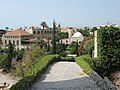
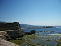
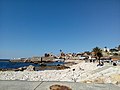
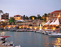
Byblos is re-emerging as an upscale touristic hub.[55] With its ancient port, Phoenician, Roman, and Crusader ruins, sandy beaches and the picturesque mountains that surround it make it an ideal tourist destination. The city is known for its fish restaurants, open-air bars, and outdoor cafes. Yachts cruise into its harbor today as they did in the 1960s and 1970s when Marlon Brando and Frank Sinatra were regular visitors to the city.[55] Byblos was crowned as the "Arab Tour Capital" for the year 2016 by the Lebanese minister of tourism in the Grand Serail in Beirut. Byblos was chosen by Condé Nast Traveler as the second best city in the Middle East for 2012, beating Tel Aviv and Dubai,[56] and by the World Tourism Organization as the best Arab tourist city for 2013.[57]

The Byblos archaeological site

[edit]
  • Ain el-Malik or King's Spring, about 20 m deep, is a large cavity accessible by spiral stairs. Once it supplied the city with water.[58] According to Plutarch's version of the Egyptian Osiris myth, the king's servants met Isis on the stairs of the spring and took her to the royal palace, where she found the body of her husband Osiris embedded in one of the palace pillars.[59]
The L-shaped Temple
  • The L-shaped Temple was erected about 2700 BC.
The Temple of the Obelisks

Other historic buildings

[edit]
  • Byblos Wax Museum

The Byblos Wax Museum displays wax statues of characters whose dates of origin range from Phoenician times to current days.

  • Byblos Fossil Museum

The Byblos Fossil Museum has a collection of fossilised fish, sharks, eel, flying fish, and other marine life, some of which are millions of years old.

  • Medieval city wall

The old medieval part of Byblos is surrounded by walls running about 270m from east to west and 200m from north to south.

  • Byblos Castle

Byblos Castle was built by the Crusaders in the 12th century. It is located in the archaeological site near the port.

Work on the church started during the Crusades in 1115. It was considered a cathedral and was partially destroyed during an earthquake in AD 1170. It was later given to the Maronite bishop as a gift by Prince Yusuf Shihab.[60]

  • Sultan Abduljid Mosque

The old mosque by the Castle dates back to the Mamluk period, and adopted the name of Sultan Abdulmejid I after he renovated it.

  • Historic Quarter and Souks

In the southeast section of the historic city, near the entrance of the archaeological site, is an old market.

  • Byblos International Festival

This summer music festival is an annual event that takes place in the historic quarter.

  • Temple of Baalat Gebal
  • Aram Bezikian Museum

The Armenian Genocide Orphans' Aram Bezikian Museum is a museum dedicated to preserving the memory of the Armenian Genocide and its survivors.[61]

Notable people

[edit]

Twin towns – sister cities

[edit]

Byblos is twinned with:

[edit]

See also

[edit]

Notes

[edit]

References

[edit]

Further reading

[edit]
[edit]
Revisions and contributorsEdit on WikipediaRead on Wikipedia
from Grokipedia

Byblos, modern Jbeil, is an ancient seaport on the Mediterranean of present-day , distinguished as one of the earliest sites of continuous with archaeological evidence of occupation dating to around 7000 BCE. Excavations have uncovered successive layers of habitation spanning from prehistoric periods through Canaanite, Phoenician, Persian, Roman, and medieval eras, underscoring its enduring role as a vital commercial and cultural nexus. As a principal Phoenician from approximately 3000 BCE, Byblos facilitated extensive maritime trade, particularly exporting Lebanese cedar timber to in exchange for goods like —whence the Greek name Byblos derives, linking to the biblical term for . The city's strategic and resources propelled its prosperity, evidenced by royal tombs, temples, and fortifications that reflect advanced societal organization and religious practices centered on deities such as Baalat-Gebal. Byblos contributed to the evolution of writing in the region, with early inscriptions in proto-Canaanite script from its territory aiding the development of the , a foundational innovation for alphabetic systems worldwide.

Geography and Environment

Location and Topography


Byblos occupies a position on the Mediterranean coast of Lebanon at 34°07′N 35°39′E. It lies approximately 30 kilometers north of Beirut along the narrow coastal strip, where the sea meets the rising terrain of the Mount Lebanon range. This placement in a natural, shallow cove formed by geological outcrops and a sandstone cliff provides inherent shelter for vessels, contributing to its suitability for maritime operations.
The topography features a jutting into the , offering defensive advantages through rocky elevations, while the immediate transitions to of , which approach closest to the shoreline here. These mountains facilitated access to upland cedar forests, essential for timber resources, contrasting with the limited flat that supported localized and settlement. Proximity to the perennial Nahr Ibrahim, a 23-kilometer river emerging from mountain springs and discharging into the sea near Byblos, ensured freshwater availability for habitation and cultivation on the otherwise constrained coastal terrain, distinguishing it from drier inland plateaus.

Climate and Natural Resources

Byblos experiences a characterized by mild, wet winters and hot, dry summers. Average winter temperatures range from 10°C to 15°C, with precipitation concentrated between and , totaling approximately 759 annually. Summers feature highs of 25°C to 30°C and minimal rainfall, fostering conditions suitable for the cultivation of drought-resistant crops such as olives, , and . The region's natural resources include extensive cedar forests historically blanketing the adjacent Mountains, providing high-quality timber ideal for construction and maritime applications due to its durability and resin content. These forests, dominated by , contributed to the area's ecological richness and resource base, while coastal proximity offered access to marine ecosystems supporting fisheries. Fertile soils in the further enabled grain production, with olives thriving in the terraced landscapes influenced by seasonal rains. Geological vulnerabilities, including moderate to high seismic activity from proximity to faults like the Yammouneh and systems, expose the site to earthquakes, as demonstrated by historical disruptions in stratigraphic layers. Coastal positioning also subjects the area to from wave action and occasional tsunamis, limiting long-term stability of low-lying settlements despite the enabling climate and resources.

Etymology

Ancient Names and Designations

The primary ancient Semitic designation for Byblos was Gubla or Gebal, a term attested in Canaanite and Phoenician contexts and derived from the root g-b-l, signifying "" or "hill," which alluded to the city's elevated tell formed by successive layers of settlement. This nomenclature reflected the topographic of the site atop an artificial mound, distinguishing it amid the and underscoring local Semitic linguistic traditions tied to landscape features. In Egyptian records dating from onward, the city was denoted as Kbn (later variant Kpn by the 18th Dynasty), a designation linked to its role as a of Lebanese cedar wood (kbn.t in Egyptian, denoting cedar), essential for Egyptian , temple , and trade expeditions documented in inscriptions like those of around 2600 BCE. This name's phonetic adaptation highlights early Nile-Levant commercial interdependence, with Byblos serving as Egypt's chief northern port for timber imports, as evidenced by archaeological finds of cedar residues and Egyptian artifacts at the site. Akkadian cuneiform texts, particularly the of the 14th century BCE, refer to the city as Gubla or Gubal, portraying it as a entity under Egyptian in diplomatic correspondence from rulers like Rib-Hadda to , thereby illustrating its integration into Near Eastern chancery practices and Akkadian as a for . The Greek appellation Byblos (Βύβλος), adopted by the Classical period, originated from búblos, the term for , stemming from the city's mediation in exporting Egyptian rolls to the Aegean world, where the imported sheets evoked local Phoenician reeds used for writing; this , preserved in ancient sources, underscores Byblos' enduring position in Mediterranean knowledge transmission.

Modern Linguistic Evolution

The Arabic name for the city, (جبيل) or Jubayl, represents a direct phonetic continuation of the ancient Semitic Gebal, maintaining continuity from medieval Islamic rule through the Ottoman period into the French Mandate era (1920–1943), where it appeared in administrative mappings of . This form reflects local Levantine pronunciation shifts, with the initial "G" softening to "J" under influence, while preserving the core root denoting the site's mountainous locale. In the mid-19th century, European scholarly interest revived the classical Greek-derived Byblos during the site's rediscovery. French orientalist led a systematic survey and initial excavations around 1860–1861 as part of his Mission de Phénicie, identifying and documenting the ancient ruins near modern Jbeil, which reintroduced the name into Western and . 's publications emphasized the site's Phoenician significance, shifting academic away from solely local variants toward the Hellenized form for its evocative link to trade and early alphabetic writing. This 19th-century revival facilitated the name's global standardization, notably influencing the site's inscription as a World Heritage property under "Byblos" in 1984, prioritizing its ancient identity in international cultural preservation efforts. Locally in , usage blends Jbeil for endogenous references—such as in governmental and communal contexts—with Byblos for heritage promotion, enhancing appeal to international visitors by associating the locale with its prehistoric and legacy rather than Ottoman-era designations.

Prehistoric Settlement

Neolithic Foundations

The earliest evidence of human occupation at Byblos dates to approximately 7000 BCE, corresponding to the period, with artifacts including flint tools and marine shells indicative of a coastal community engaged in and rudimentary gathering. These findings, recovered from basal stratigraphic layers, suggest initial semi-sedentary campsites rather than fully urbanized entities, supported by the presence of simple lithic implements and faunal remains without signs of intensive fortification or large-scale construction. Obsidian artifacts, sourced from Anatolian deposits over 900 kilometers distant, point to nascent exchange networks facilitating the import of high-quality raw materials for tool production, underscoring Byblos's early integration into regional interaction spheres despite its modest scale. Excavations directed by Maurice Dunand in the mid-20th century delineated the sequence into three phases—Ancien, Moyen, and Récent—stratified across multiple levels, with the foundational layers (approximating Level V) yielding evidence of transitioning through approximately 33 stone-built houses associated with domestic activities. These rectilinear structures, lacking mud-brick elements in the earliest contexts, enclosed spaces for processing domesticated cereals, as inferred from grinding areas and botanical residues, marking a shift from ephemeral camps to more stable farming settlements reliant on and cultivation alongside caprine . such as flint daggers and stone axes from these levels further attest to organized subsistence and rudimentary social practices, without monumental that might imply centralized authority or rapid . This gradual material progression aligns with empirical stratigraphic , prioritizing localized exploitation over exogenous impositions of .

Chalcolithic Transitions

The period at Byblos, dated roughly to 4500–3800 BCE based on radiocarbon evidence from burials, represents a transitional phase between simplicity and later developments, with initial adoption of metallurgy alongside persistent lithic traditions. tools, including simple implements like awls and adzes, appear in the , sourced likely from regional ores and signaling early experimentation with annealing techniques rather than full . evolves with incised and combed decorations on vessels, often associated with storage and ritual use, reflecting refined craftsmanship tied to sedentary intensification. Excavations by Maurice Dunand in the delineated stratigraphic levels III and IV within this phase, uncovering rectangular platform structures interpreted as proto-temples, constructed from local stone and oriented toward communal gatherings. These features, alongside evidence of blades imported from Anatolian sources such as , indicate exchange networks compensating for the scarcity of fine-quality flints locally, which incentivized craft specialization and inter-regional contacts. 's prevalence in tool assemblages—comprising up to 20% of lithics in some deposits—underscores causal pressures from resource depletion driving maritime or overland procurement, distinct from purely local economies. Funerary practices further evidence rising social differentiation, with a dedicated extramural yielding over 2,000 jar burials, predominantly of infants and subadults, accompanied by 3,652 including shell beads, flint tools, and ceramic vessels. Variations in grave inclusions, such as clusters of high-value items like artifacts in select jars, suggest nascent hierarchies, possibly linked to kin-based elites controlling access, though domestic settlement traces remain sparse relative to burial . Expansion of the occupied tell area during this era implies demographic pressures, inferred from increased structural and discard volumes, without direct data, fostering conditions for the cooperative labor evident in temple platforms. This phase's innovations in and ritual architecture laid groundwork for subsequent urban scaling, driven by adaptive responses to environmental and subsistence constraints rather than exogenous impositions.

Bronze Age Developments

Early Bronze Age Expansions

During the Early Bronze I-II phases (ca. 3200–2700 BCE), Byblos experienced significant urban expansion characterized by the development of fortified settlements, including the construction of defensive city walls that enclosed expanding residential areas. These walls, initially built around 2700 BCE, marked the site's transition to a proto-urban center with organized defenses, reflecting increased social complexity and resource control in the northern Levant. Residential structures featured multi-room houses typically comprising 2–5 rooms arranged around open-air courtyards, indicative of household-based economies involving agriculture, animal husbandry, and early craft specialization. Pottery assemblages from these strata show influences from Syrian traditions, including painted wares and forms suggesting cultural exchanges with inland northern Levantine and Syro-Mesopotamian regions, which facilitated technological and stylistic adoptions in local production. Byblos emerged as a key in regional trade networks, exporting Lebanese cedar wood—sourced from hinterland forests—to , where demand drove exchanges as early as the late fourth millennium BCE and intensified in the Early Bronze period. In return, the city imported metals and prestige goods, with archaeological evidence including Egyptian artifacts such as tools and vessels attesting to maritime connections that positioned Byblos as a gateway between the and Valley. practices are evidenced by specialized vessels, potentially including kernos-like forms for offerings, found in domestic and temple contexts, underscoring the integration of into communal ceremonies amid urban growth. The EB III phase (ca. 2700–2200 BCE) saw continued enhancements and settlement density, but this period culminated in widespread disruptions across the , including at Byblos, where abandonment layers and reduced signal a around 2200 BCE. Factors contributing to this contraction included associated with the 4.2 ka event, leading to resource , drier conditions, and socioeconomic strain, though Byblos retained some urban continuity unlike southern sites. Evidence of violence or catastrophe appears in disturbed strata, with parallels to mass interments elsewhere in the region, reflecting systemic vulnerabilities in overextended Early Bronze urban systems rather than isolated local events.

Middle Bronze Age Flourishing

During the Middle Bronze Age, approximately 2000–1600 BCE, Byblos experienced significant economic prosperity driven by its control over Lebanon's cedar forests, which generated trade surpluses through exports to timber-scarce . This resource monopoly, rooted in Byblos's coastal position adjacent to Mount Lebanon's highlands, facilitated maritime shipments documented in Egyptian Middle Kingdom texts, including references to cedar procurement in the Tale of Sinuhe, where the protagonist encounters Levantine rulers amid broader regional . These surpluses funded monumental constructions, such as fortified palaces and administrative complexes, rather than mere , as evidenced by stratigraphic layers showing enhanced urban defenses from MB IIA onward. Archaeological evidence from royal shaft tombs underscores this wealth accumulation, with burials containing imported luxuries like beads and vessels, sourced via overland routes from through Mesopotamian intermediaries to the Levantine coast. These tombs, primarily dated to MB IIA (ca. 2000–1800 BCE) through ceramic and burial typology synchronized with Egyptian strata at Tell el-Dabʿa, feature precursors to later Phoenician sarcophagi in their stone-cut chambers and rich , indicating elite centralization under kings who managed concessions. Hypogeum-style underground temples and necropolises, integrated into the fortified tell, reflect and political consolidation, with MB IIB–IIC phases (ca. 1800–1600 BCE) showing rebuilt structures atop earlier foundations, marking a shift toward more robust, enclosed . The causal link between cedar-derived revenues and architectural elaboration is apparent in the scale of defenses, including stone glacis up to 50 meters thick on eastern ramparts, which protected the harbor and residences against regional while enabling sustained exports. This era's autonomous flourishing, prior to intensified Egyptian oversight in the Late Bronze Age, positioned Byblos as a semi-independent , with assemblages yielding Egyptian-style artifacts exchanged for timber rather than imposed by .

Late Bronze Age Interactions

During the Late Bronze Age (c. 1600–1200 BCE), Byblos functioned as a under Egyptian overlordship, with its ruler Rib-Hadda dispatching around 60 letters in the Amarna archive to Pharaoh Akhenaten (r. c. 1353–1336 BCE), primarily pleading for troops and resources to counter threats from regional rivals such as Abdi-Ashirta of Amurru and incursions by the Habiru. These missives, cataloged as EA 68–96 and others, underscore Byblos's strategic dependency on ian military support amid local power struggles, including accusations of piracy and territorial encroachments by neighboring like . Rib-Hadda's correspondence reveals a controlling subordinate towns but vulnerable to diplomatic maneuvering, as rivals sought Hittite alliances, though Byblos itself remained firmly aligned with rather than facing direct Hittite subjugation. Byblos occupied a pivotal role as a in Egyptian-Levantine diplomacy, buffering Egyptian interests against northern powers like the , whose expansions into created tensions resolved partially by the Egyptian-Hittite peace treaty c. 1259 BCE. Cultural exchanges with , a Hittite-aligned center to the north, are attested in shared Levantine pottery forms and Syrian religious elements, such as cult steles and baityloi (sacred stones), which integrated into Byblos's temple practices alongside Egyptian influences like the cult. Archaeological finds, including Mycenaean imports via Ugaritic trade routes, highlight Byblos's embeddedness in broader networks, though its autonomy was curtailed by Egyptian oversight. The period's close brought decline, coinciding with broader Late Bronze Age upheavals around 1200 BCE, including migrations that disrupted Levantine trade; while Byblos avoided major destruction, evidence points to economic contraction through diminished imports of Egyptian and Aegean goods, alongside reduced settlement extent and a shift to peripheral status. This downturn, marked by hardship in sustaining prior prosperity, set the stage for transformations without direct attribution to violence at the site itself.

Iron Age and Phoenician Period

Emergence of Phoenician Identity

Following the around 1200 BCE, Byblos exhibited continuity in settlement and political structure, transitioning into the as a key coastal within the emerging Phoenician cultural sphere, characterized by shared Semitic language, script, and maritime orientation rather than a unified ethnic . Archaeological strata at the site reveal rebuilding of temples and fortifications, with no evidence of total abandonment, supporting a model of local adaptation amid regional disruptions from migrations and trade interruptions. This period marks the consolidation of "Phoenician" identity as a pragmatic ethnolinguistic label applied retroactively by outsiders like , but rooted in Canaanite predecessors who intensified seafaring to compensate for depleted inland resources such as cedar forests, exhausted by prior Egyptian demands spanning millennia. Verifiable textual evidence includes the inscription from Byblos, dated circa 1000 BCE, the earliest known Phoenician-language text, employing a 22-letter consonantal derived from Proto-Canaanite precursors and inscribed in a style distinct from earlier syllabic or hieroglyphic systems used at the site. This artifact, discovered in a royal tomb, records a curse against tomb violators, reflecting monarchical authority and linguistic standardization that facilitated trade records across Levantine ports. Five such Byblian royal inscriptions from 1200–1000 BCE demonstrate phonetic shifts and formulaic phrasing aligning with broader Phoenician conventions, underscoring cultural cohesion without implying political unity. By the 9th–7th centuries BCE, Assyrian imperial records document Byblos' integration into networks, with kings like Yehimilk (via his temple dedication inscription) asserting independence while submitting to overlords, as evidenced by Ashurbanipal's (circa 668–631 BCE) listing from the ruler of Byblos alongside other Levantine cities, including metals and timber. This vassalage highlights causal pressures: Assyrian expansion compelled Phoenician polities to leverage maritime prowess for revenue, with Byblos exporting purple dye and importing iron tools, as inferred from cargoes and port deposits. Resource scarcity—evidenced by reduced local cedar pollen in regional cores—drove innovations like advanced hull for longer voyages to and , fostering a trade-centric identity over territorial conquest.

Trade Networks and Innovations

Byblos functioned as a central node in the expansive Phoenician maritime trade networks during the Iron Age, connecting the Levant to distant regions including the western Mediterranean. Merchants from Byblos participated in voyages sourcing tin from the Tartessian mines in southern Iberia (modern Spain), a critical commodity for alloying bronze and sustaining metallurgical industries across the Near East. These routes also supported the establishment of overseas colonies, such as Carthage in present-day Tunisia around 814 BCE, which served as waystations for grain, timber, and precious metals while mitigating risks from overland disruptions. A cornerstone of Byblos' economic output was its role in the production and export of purple dye derived from shellfish, harvested in vast quantities from coastal waters. Extraction involved crushing thousands of snails to yield the labor-intensive pigment, which dyed luxury textiles commanding high value in elite markets from to ; archaeological shell heaps at Phoenician sites quantify the industrial scale, with estimates of over 10,000 mollusks per gram of dye. This industry, intertwined with and cedar-derived ship masts, generated wealth that funded further expeditions, though processing odors and toxicity posed environmental and health costs borne by laborers. Technological innovations underpinned these networks' efficiency, including advances in ship construction such as reinforced hulls and cutwater prows that enhanced stability and speed in open seas, enabling reliable navigation via celestial observations rather than coastal hugging. Byblos contributed to the evolution of writing systems, with its mid-2nd millennium BCE syllabary—featuring pseudo-hieroglyphic signs—representing an early syllabic script that presaged phonetic simplification, though remaining undeciphered and distinct from the later fully alphabetic Phoenician system adapted around 1050 BCE for commercial ledgers. The decentralized structure of these trade empires—autonomous city-states coordinating via ties and shared maritime expertise—fostered adaptability to fluctuating demand and , allowing Byblos to pivot resources amid regional scarcities. Yet this reliance on sea lanes exposed vulnerabilities to adversarial interdictions; Assyrian military campaigns in the late 8th and 7th centuries BCE, culminating in demands and controls, exemplified how conquests could throttle access to key routes, precipitating economic contraction through enforced monopolies and reduced export volumes.

Classical and Post-Classical Antiquity

Hellenistic and Roman Influences

Following the conquest of the by in 333 BCE, Byblos entered the Hellenistic era under successive Macedonian successor states, with Ptolemaic Egypt exerting control during much of the third century BCE before Seleucid Syria assumed dominance from the early second century BCE until Roman annexation. This period saw the integration of Greek administrative practices and cultural elements into local Phoenician structures, though Byblos retained its role as a coastal node amid regional power struggles over . In 64 BCE, Roman general the Great incorporated Byblos into the province of , elevating it to colonia status and styling it Ieras Byblou (" of Byblos"), which formalized its governance under imperial oversight while acknowledging longstanding sacred traditions. Local autonomy diminished as provincial administration centralized fiscal and military authority, evidenced by limited civic coinage production that featured hybrid iconography—such as local deities alongside Roman imperial motifs—rather than independent royal issues of prior eras. Roman infrastructural investments transformed urban layout and sustainability, including an aqueduct channeling water to the ancient tell well, a colonnaded cardo for processions, an odeon for assemblies, and porticos enhancing commercial viability along main thoroughfares. A erected in the late second century CE exemplified , feeding public fountains and baths amid city expansion to the lower harbor plain. These developments supported economic continuity as a maritime , shifting emphasis from depleted upland timber extraction toward diversified coastal commerce under regulated provincial trade networks. Pagan characterized the era, with the venerable temple of Baalat-Gebal—the "Lady of Byblos"—sustaining use into Roman times alongside cults of , incorporating Hellenistic and Roman ritual overlays without wholesale supplanting by Olympian equivalents like . Local festivals and small Corinthian-columned shrines on the perpetuated these blended practices, reflecting pragmatic accommodation of Phoenician deities to imperial tolerance prior to later Christian ascendancy.

Transition to Byzantine Era

In the late , following the permanent division of the in 395 CE, Byblos transitioned under Byzantine administration as part of Prima, with becoming the dominant faith after its official toleration under Constantine I (r. 306–337 CE). A bishopric was established at Byblos, functioning as a suffragan see to the metropolitan of Tyre, evidenced by ecclesiastical records listing its participation in regional synods by the . Churches proliferated in the lower town near the northern port, often utilizing from dismantled Roman-era pagan temples, reflecting a broader of Christian of pre-existing sacred spaces in the region. Nearby sites, such as Yanouh, yielded a 5th-century Byzantine incorporating temple walls, column drums, and architraves, indicative of similar architectural reuse at Byblos amid the suppression of pagan cults. A major in 551 CE inflicted severe damage on Byblos alongside coastal towns like Botrys and Tripolis, compromising and urban cohesion. This vulnerability was exacerbated during the Byzantine-Sassanid War (602–628 CE), when Persian forces under overran after capturing in 614 CE, leading to occupation, disrupted defenses, and partial population dispersal as residents sought refuge inland or in fortified enclaves. The rerouting of eastern trade via Red Sea ports like Berenice Troglodytica diminished Byblos' maritime prominence, shifting commerce southward through Alexandrian intermediaries and reducing local revenues, which fostered overreliance on Byzantine imperial subsidies for sustenance. These pressures eroded the city's late antique stability, paving the way for diminished in the ensuing era.

Medieval and Early Modern History

Arab Conquests and Crusader Era

The Arab conquest of Byblos occurred in 637 CE as part of the broader Muslim invasion of the , which expelled Byzantine control from the region. Under Umayyad rule (661–750 CE), the city experienced apparent neglect, with archaeological evidence showing minimal construction or activity compared to preceding Roman and Byzantine periods. This stagnation likely stemmed from shifted economic priorities inland rather than coastal ports, though the city retained its strategic coastal position. During the Fatimid Caliphate (969–1099 CE), Byblos regained some importance as a port, with fortifications established to support maritime functions amid regional instability. These defenses, constructed on earlier structures, underscored the site's role in Fatimid naval logistics, though overall development remained limited without major urban expansion. Byblos, known to Crusaders as Gibelet, was captured by Frankish forces around 1104 CE and incorporated into the County of Tripoli, established as a Crusader state by 1109 CE under Raymond IV of Toulouse. The Embriaco family, of Genoese origin, held the lordship, leveraging the site's position for defense and trade. In response to threats from Muslim forces, including Saladin's campaigns following the 1187 Battle of Hattin, Crusaders erected a rectangular citadel in the 12th century, utilizing local limestone and salvaged Roman columns for walls and a moat, measuring approximately 50 by 45 meters. This fortress served as a key bulwark in the County, facilitating intermittent trade revivals with European merchants despite ongoing hostilities. Saladin's regional offensives pressured coastal strongholds, leading to a partial of Gibelet's walls and fortress in 1190 CE by his order, preempting potential reinforcements after Frederick Barbarossa's death. No full-scale of Byblos is recorded, unlike nearby Tripoli's failed 1188 , but these conflicts inflicted structural on pre-existing walls, prioritizing military confrontations over preservation. Religious motivations fueling these wars—Crusader incursions and Ayyubid reconquests—disrupted long-term continuity more than internal economic factors, as evidenced by the reactive efforts and sporadic destruction outweighing any sustained decay. Crusader presence temporarily boosted commerce through Italian seafaring networks, contrasting the sieges' toll, until advances ended Frankish control in 1291 CE.

Mamluk and Ottoman Dominion

Following the Mamluk conquest of the remaining Crusader positions in the Levant, including the destruction of Acre in 1291, forces under Sultan al-Nasir Muhammad targeted Byblos (Jubayl) in 1302, razing its walls and fortress to eliminate potential bases for Christian reconquest while sparing the inhabitants. The port facilities, previously utilized for regional trade, saw reduced activity as the Mamluks prioritized control over coastal strongholds, shifting Byblos toward subsistence fishing and local commerce in a fortified but diminished settlement. In 1516, after the Ottoman defeat of the Mamluks at the Battle of Marj Dabiq, Byblos was integrated into the Ottoman Empire as part of the sanjak of Tripoli within the eyalet of Damascus. The Ottoman millet system afforded Maronite Christian communities administrative autonomy in religious and civil matters, yet non-Muslims bore the jizya poll tax alongside other levies, contributing to economic pressures on the populace. Administrative continuity emphasized tax collection over infrastructure investment, with the town retaining its medieval walls while adding modest structures like a khan and souk for limited mercantile functions. Throughout the Ottoman era, Byblos persisted as a small with sparse development, as documented by 19th-century observers, its population hampered by recurrent plagues, intertribal conflicts, and the burdens of imperial taxation that deterred expansion beyond basic livelihoods. Economic records indicate reliance on coastal resources rather than revived maritime trade, underscoring a period of stagnation relative to the site's ancient prominence.

Modern and Contemporary Era

19th-Century Revival and Independence

The of 1860 in , pitting militias against Maronite , culminated in massacres that killed up to 20,000 and displaced tens of thousands, drawing European powers into intervention to protect Ottoman Christian subjects. French forces landed in on August 16, 1860, under an Anglo-French agreement, pressuring the Ottoman Porte to establish the Mutasarrifate of in 1861 as a semi-autonomous Christian-majority under a European-appointed , which included Byblos (Jbeil) and stabilized the region until 1918. This autonomy, rooted in reform efforts to centralize and modernize Ottoman administration, curbed local feudal power and fostered relative economic recovery through improved security, though Byblos itself remained a modest port town reliant on agriculture and trade. Amid these events, French orientalist led an archaeological mission that surveyed and partially excavated Byblos in 1860–1861, uncovering Phoenician remains and publicizing the site's antiquity, which stimulated European scholarly and cultural interest in Lebanon's pre-Arab heritage. Tanzimat-era infrastructure, including expanded road networks linking interiors to coastal ports like by the 1870s, facilitated peasant emigration—peaking after the 1873–1896 Ottoman and local silk industry collapse—with over 100,000 Lebanese departing for the by 1914, their remittances funding local building, land purchases, and trade revival in towns like Byblos. Following Ottoman collapse in , French mandatory authorities proclaimed the on September 1, 1920, expanding boundaries from the 1861 Mutasarrifate to incorporate coastal enclaves including Byblos, aiming to create a viable Christian-anchored amid Syrian fragmentation. Byblos, as Jbeil, integrated into this framework, benefiting from mandate-era investments in education and archaeology that preserved Phoenician sites as symbols of distinct Lebanese identity. Lebanon's independence from , formalized in 1943 via the allocating the presidency to , elevated ancient Byblos in nationalist narratives, with Maronite leaders invoking Phoenician roots to assert cultural continuity against pan-Arab claims.

Post-1943 Challenges and Recent Events

During the from 1975 to 1990, which claimed an estimated 150,000 lives and displaced around one million people, Byblos underwent significant population displacements as residents fled sectarian violence concentrated in and southern regions, though its archaeological core endured minimal direct structural damage owing to its peripheral location in . Local communities faced economic strain and militia incursions that disrupted daily life, yet the UNESCO-listed site's ancient fortifications and temples avoided the widespread looting and bombardment seen elsewhere, preserving stratigraphic integrity for future study. The 2006 Israel-Hezbollah War, lasting 34 days and displacing over 900,000 Lebanese, inflicted heavy damage on southern infrastructure—destroying 30,000 homes and 109 bridges—but spared Byblos from substantive shelling, with reports indicating only peripheral effects like temporary access restrictions rather than site-specific destruction. This relative insulation allowed continuity in basic site guardianship amid national reconstruction efforts that prioritized southern recovery. Lebanon's , intensifying from 2019 with exceeding 200% annually and a banking locking depositors' funds, compounded by the August 4, 2020, Beirut port explosion that killed 218 and crippled government capacity, indirectly jeopardized Byblos's maintenance through slashed heritage budgets and stalled conservation projects. The blast's shockwave, felt 30 kilometers north, caused no verified structural harm to the site but exacerbated national fiscal paralysis, raising concerns over compliance as erosion and neglect accelerated without funding for coastal stabilization. Archaeological publications persisted amid instability, including 2023 analyses of settlements and 2024 studies on Early and Middle deposits revealing trade artifacts undamaged by modern crises. Escalating Israeli airstrikes in from September 2024, amid the Israel-Hezbollah conflict, heightened risks to northern heritage including Byblos, with strikes near and Tyre prompting to place 34 sites under provisional enhanced protection by November 2024 to avert collateral damage from precision operations targeting militant infrastructure. As of October 2025, no direct hits on Byblos were confirmed, but proximity to potential escalation zones—coupled with over 10,000 structures damaged nationwide since October 2024—underscored vulnerabilities to seismic-like vibrations and disruptions for ongoing excavations. Lebanese officials warned that unchecked bombardment could irreversibly compromise the site's mound integrity, echoing broader threats to 20% of the country's assets.

Demographics

Population Statistics

The population of Byblos, the urban core of Jbeil (also known as Byblos), is estimated at to residents based on municipal boundaries and recent assessments. The surrounding Byblos District recorded an estimated 99,388 inhabitants as of December 2017, reflecting a broader approaching 100,000 when including adjacent rural zones. Lebanon's absence of a national since contributes to reliance on such estimates derived from surveys and administrative data. Population density centers on the coastal , with approximately 231 inhabitants per square kilometer across the district's 430 square kilometers, indicating a pronounced urban-rural divide favoring the historic zone over inland villages. From 1975 to 2015, Byblos's registered declined by 59.9 percent, driven primarily by amid the and subsequent instability. The economic collapse beginning in late 2019, marked by exceeding 200 percent annually by 2020 and currency devaluation, intensified depopulation through accelerated outflows, particularly of working-age youth, resulting in an aging demographic profile consistent with national trends of low fertility rates around 1.7 births per woman. Between 2019 and 2023, saw heightened waves, with over 195,000 departures recorded by 2021, further straining local in areas like Byblos.

Religious and Ethnic Composition

Byblos, within the , maintains a Maronite Catholic majority, with ecclesiastical statistics from the of Jbeil indicating 145,000 Catholics as of December 31, 2022, in a estimated at approximately 99,000 in 2017. This dominance reflects the area's role as a Christian stronghold, where constitute the primary confessional group amid Lebanon's confessional mosaic. Greek Orthodox form a notable minority, alongside Shia Muslims as the principal Muslim community, with smaller Sunni Muslim, Armenian Orthodox, and other Christian denominations present. Ethnically, residents are overwhelmingly of Levantine Arab descent, tracing ancestry to ancient Phoenician inhabitants blended with subsequent migrations, though Maronite communities often emphasize pre-Arab Phoenician continuity in identity narratives to underscore cultural distinctiveness. A small Armenian ethnic minority persists, descendants of Ottoman-era refugees, numbering among the district's diverse fabric. Since 2011, Syrian refugees—predominantly Sunni Muslim—have integrated modestly, comprising part of the non-Lebanese resident population of about 11,500 in the as of recent surveys, without significantly altering the entrenched balance. The Ottoman millet system, by affording religious minorities semi-autonomous governance, preserved Maronite demographic and institutional cohesion in enclaves like Byblos, countering pressures toward Islamic homogenization under prolonged Muslim rule and enabling resilience through the French Mandate and post-independence era. Scholarly debates persist over interpreting Byblos's ancient Phoenician heritage: some Maronite viewpoints frame it as a proto-Christian lineage resistant to Arab nationalist assimilation, while broader Lebanese discourses integrate it into a unified Semitic-Arab historical continuum, highlighting tensions in national identity formation.

Economy and Tourism

Economic Foundations

Byblos's economy, like much of coastal , draws on small-scale and adapted to its Mediterranean . Local operations, primarily using small boats for near-shore catches, provide essential protein and income for residents, aligning with national fisheries output of approximately 3,000 to 3,500 metric tons annually in the mid-2010s, though production has since declined amid fuel shortages and market disruptions. focuses on olives and fruits such as and apples, cultivated on terraced slopes with limited ; olive production in , encompassing Byblos, contributes to the country's estimated 154,000 tons of annual olive fruit yield, with much processed into oil for local and export markets. These sectors, however, represent a shrinking share of GDP, with , , and collectively at about 2.5% nationally by 2022, hampered by and soil degradation. Remittances from the form a critical pillar, injecting foreign into households and sustaining consumption beyond local production. In 2023, received $6.7 billion in remittances, equivalent to 30.7% of GDP, with coastal areas like Byblos benefiting from expatriate networks in and the Gulf; these inflows support informal lending and imports but correlate weakly with broader growth, often fueling rather than . This reliance underscores historical adaptability—rooted in Byblos's ancient legacy—but exposes vulnerabilities, as remittance drops (e.g., 13% year-on-year in 2024) exacerbate amid 's real GDP contraction of over 38% since 2019. The 2019 and ensuing currency collapse (with the lira losing over 90% of its value) shifted economic activity toward informal trade networks, including and dollar-denominated exchanges in local markets. Labor informality rose from 55% in 2019 to 63% by 2022, enabling survival through unregulated commerce in goods like and but eroding revenues and formal . Efforts at cedar reforestation, symbolizing Lebanese resilience, remain constrained by funding shortfalls and conflict, yielding limited economic returns despite initiatives like the Lebanon Reforestation Initiative. Overall, these foundations highlight a : geographic assets foster subsistence resilience, yet structural dependencies risk amplifying shocks from external factors like outflows or regional instability, without robust diversification.

Tourism Industry and Site Management

Byblos functions as a key tourist hub in , drawing visitors to its UNESCO-listed ancient ruins, Crusader-era , and Phoenician port remnants. Prior to 's 2019 economic and protests, the country hosted around 1.9 million tourists annually, with Byblos contributing significantly as one of five major heritage destinations promoted by the government. revenue from such sites supported local economies, though specific figures for Byblos remain aggregated within national totals peaking at $8.6 billion in 2019. Designated a in 1984, Byblos has implemented management strategies to curb threats like artifact looting and environmental degradation, including emergency stabilization works such as backfilling eroded temple foundations with geotextiles. These efforts, coordinated with and local authorities, prioritize conservation alongside controlled , with plans for sustainable visitor flows and regular site maintenance to prevent irreversible damage. In 2016, declared additional protected zones within the site to reinforce heritage attributes against urban pressures. The have seen plummet due to Lebanon's security instability, including civil unrest, , and regional tensions, resulting in international advisories that deter visitors and reduce arrivals to fractions of pre-crisis levels. Encroachment by developers exacerbates preservation challenges, as in the 2015-2016 dispute over the Bird's Nest Armenian adjacent to the site, where proposals to raze graves for a sparked community opposition and temporary halts, highlighting tensions between commercial development and historical integrity. Balancing tourism's economic benefits against site integrity reveals causal trade-offs: high visitor volumes generate but accelerate artifact and structural , underscoring the need for restricted access to safeguard empirical archaeological data over short-term gains. guidelines advocate such limits in management plans, though quantified studies at Byblos are scarce, with focus instead on proactive interventions like those post-2006 conflict oil spill recoveries.

Archaeology and Excavations

Stratigraphic Layers and Key Sites

The stratigraphic sequence at Byblos, as established through excavations led by Maurice Dunand from 1926 to 1977, encompasses layers from the period through the Roman era, with the central tell accumulating approximately 20 meters of deposit over millennia. Dunand's methodology employed artificial 20 cm layers for precision, revealing a continuous occupational history punctuated by phases of temples, fortifications, and residential areas on the . The tell's facilitated preservation of these strata, including early settlements at its base transitioning to structures higher up. Key sites include the royal in the lower city, comprising nine underground shaft and chamber tombs dating to the Middle and Late Bronze Ages, accessed via vertical shafts leading to burial chambers. Prominent religious loci on the tell feature the Temple of Baalat-Gebal, a multi-phase dedicated to the city's patron , and the adjacent Temple of Reshef, characterized by Egyptian-influenced architecture and votive deposits. The Temple of the Obelisks, an L-shaped complex from the Middle Bronze Age (circa 2000–1600 BCE), stands out with its monumental stone obelisks and ritual pits, integrated into the broader temple precinct. The ancient harbors, situated along the coastal plain southeast of the tell, exhibit progressive silting from alluvial sediments and marine deposition, obscuring early quays and basins over time. French archaeological missions, initiated by Pierre Montet in 1921–1924 and extended by Dunand through the 1970s under mandate and post-independence auspices, systematically mapped these features via annual campaigns. Lebanese excavations have since ensured methodological continuity, focusing on exposed sections and unexcavated areas to refine the site's vertical and horizontal .

Major Discoveries and Artifacts

One of the most significant artifacts from Byblos is the of King Ahiram, discovered in 1923 within the royal following a that exposed Phoenician royal tombs. Dating to approximately 1000 BCE, the limestone features intricate bas-relief carvings depicting mourning women, a funeral procession, and confronting figures on the lid, alongside a 38-word Old Phoenician inscription considered the earliest extended alphabetic text, serving as a curse against tomb violators. The inscription, in the Byblian dialect, confirms Ahiram's kingship and highlights early Phoenician linguistic development, with the artifact now housed in the . Egyptian influences are evident in statues and dedications from the New Kingdom period, including items linked to (r. 1279–1213 BCE), who commissioned structures like a chapel in the Temple of the Obelisks, underscoring Byblos' role as a key trading partner receiving pharaonic tribute and oversight. Inscribed statuettes and relief fragments from this era, found in temple contexts, depict Egyptian motifs adapted locally, evidencing diplomatic and economic ties that supplied cedar wood to in exchange for luxury goods. Bronze Age discoveries include a substantial arsenal of nearly 900 metal weapons, primarily from Middle Bronze Age I (2000–1750 BCE), such as swords, daggers, spears, and axes unearthed in temple and residential areas, indicating Byblos' military capabilities and metallurgical expertise amid regional trade networks. Accompanying these are ivory artifacts, like handles on votive daggers from the Temple of the Obelisks (2000–1800 BCE), often combined with gold and silver, which demonstrate imports from regions like Africa and India, verifying extensive commerce in raw materials and finished luxury items. Iron Age sarcophagi from the royal , beyond Ahiram's, feature Phoenician motifs blending local styles with Egyptian derivations, such as sphinxes, palmettes, and winged disks on stone and marble surfaces, as seen in anthropoid examples from the 9th–8th centuries BCE, which housed burials and reflect evolving funerary practices. Recent analyses, including 2023 publications, have reexamined common commodities like ceramics and metals from Byblos excavations to trace their lifecycle and trade trajectories, extending understandings of everyday economic exchanges beyond treasures. In 2024, documentation of an intact yielded further artifacts, including preserved , reinforcing chronologies of early urban development.

Methodological Debates and Recent Research

Scholars have long debated the authenticity of of Byblos's second-century CE translations of 's purported Phoenician writings, with many arguing that the cosmogonic and historical accounts represent Hellenistic inventions rather than genuine pre-Hellenistic Phoenician . claimed to draw from temple inscriptions and priestly records accessed by centuries earlier, but critics, including modern philologists, highlight anachronistic philosophical elements akin to Greek rationalism and , suggesting fabrication to Hellenize Phoenician lore amid Roman-era cultural synthesis. While some defend partial antiquity based on parallels with , empirical linguistic analysis favors viewing the work as 's composition, undermining its use for reconstructing pre-300 BCE Byblos narratives without corroboration from archaeological strata. Radiocarbon dating of Neolithic layers at Byblos reveals tensions with traditional stratigraphic correlations, as limited samples from domestic contexts yield calibrated dates around 8000–6000 BCE that occasionally conflict with artifact-based chronologies tied to regional pottery sequences. For instance, absence of direct dating in early Neolithic phases has prompted reliance on comparative typologies from sites like Ard Tlaili, but emerging Bayesian modeling of sparse charcoal data suggests compressed timelines, challenging diffusionist models that link Byblos's lithic traditions (e.g., Byblos points) to Anatolian imports without local continuity. These discrepancies underscore methodological pitfalls in calibrating pre-pottery horizons, where old wood effects and sample inflate variances, necessitating integrated geoarchaeological proxies for resolution. Recent analyses of deposits, including 2024 radiocarbon suites from Early Bronze contexts, have refined chronologies by anchoring urban expansions to circa 3000–2500 BCE, reconciling prior divergences between Egyptian import scarabs and local ceramic phases through high-precision dating of short-lived organics. Studies from Byblos's monumental enclosures demonstrate that these techniques narrow the end of Early Bronze III to approximately 2500 BCE, countering over-reliance on historical synchronisms with Valley rulers that previously extended timelines by centuries. Such refinements privilege empirical sequences over artifact typology alone, revealing pulsatile local developments amid trade networks. Controversies persist over interpretive biases emphasizing Egyptian diffusion at the expense of indigenous agency, as evidenced by critiques of models portraying Byblos's Early temples and fortifications as mere adaptations of prototypes. Empirical reassessments highlight local stone-working traditions in constructing multi-phase sanctuaries, predating peak Egyptian contacts and indicating autonomous monumentalism driven by coastal resource control rather than imported ideologies. Recent 2023 investigations into settled life further counter diffusionism by documenting indigenous architectural clusters and subsistence patterns, attributing urban precursors to Levantine environmental adaptations over exogenous impositions, thus restoring causal priority to regional dynamics in Byblos's trajectory. This shift demands methodological caution against Egyptocentric narratives, favoring multi-proxy evidence to delineate from origination.

Cultural Significance and Legacy

Phoenician Contributions to Civilization

The Phoenicians, with Byblos as a pivotal early city, introduced the proto-alphabetic script around 1200–1050 BCE, evolving from earlier Proto-Canaanite forms into a consonantal system of 22 letters that prioritized phonetic efficiency over complex syllabaries or ideograms. This innovation facilitated widespread literacy among traders and artisans, enabling precise commercial records and across the Mediterranean, as evidenced by inscriptions on Byblos-sourced artifacts traded to and . Unlike logographic systems requiring years of training, the Phoenician alphabet's simplicity lowered barriers to writing, laying groundwork for Greek adaptations by the 8th century BCE and subsequent Western scripts, though its spread relied on pragmatic trade incentives rather than deliberate proselytizing. Maritime advancements, including robust cedar-built galleys and early warships with dual oar banks for enhanced speed and maneuverability, revolutionized Mediterranean connectivity from the late BCE. Byblos's shipyards produced vessels capable of 450-ton cargoes, dubbed "Byblos boats" by for deep-sea voyages that linked Levantine ports to Iberia and . These innovations spurred decentralized trade networks, exporting timber, , and metals while importing tin and , fostering among city-states without centralized imperial control. However, this often involved raiding and enslavement of war captives, as Phoenician crews supplemented crews and labor pools, challenging narratives of exclusively pacific . The production of dye from snails, refined in coastal workshops near Byblos and Tyre by the 15th century BCE, exemplified resource-intensive innovation yielding a colorfast valued at 10–20 times gold's weight. Requiring extraction from thousands of snails per gram via fermentation processes documented in ancient texts, it generated wealth through elite markets but depended on arduous, likely coerced labor, including slaves from conflicts. This industry's supported fiscal for Phoenician polities, yet its environmental toll—vast shell middens—and exclusivity underscored causal trade-offs: prosperity tied to extraction efficiencies rather than egalitarian ideals. Overall, these contributions stemmed from adaptive realism in navigating geography and markets, prioritizing empirical utility over expansive conquests.

Scholarly Interpretations and Controversies

Scholars debate the continuity between Canaanite and Phoenician identities at Byblos, with a consensus viewing Phoenician culture as an evolution from Late Canaanite koine following the circa 1200 BCE regional collapse, rather than a distinct ethnic rupture. This perspective emphasizes material and linguistic persistence, such as shared temple architectures and Semitic dialects, over self-identification as "Phoenician," a term largely imposed by external Greek observers. Alternative views positing a sharper break, often tied to nationalist reconstructions, lack support from stratigraphic evidence at Byblos, where ceramic and inscriptional sequences show gradual adaptation without mass population replacement. Philo of Byblos's second-century CE Phoenician History, purporting to translate pre-Trojan War cosmogonies from , faces scrutiny for euhemeristic reinterpretations—treating deities as deified ancestors—and Hellenistic rationalizations that overlay Greek philosophical frameworks on purported native lore. While fragments preserved via offer rare Phoenician mythological insights, authenticity doubts arise from Philo's bilingual context in Roman Syria-Phoenicia, where cultural hybridity likely amplified to appeal to Greco-Roman audiences, diminishing claims of unadulterated transmission. Baumgarten's commentary highlights inconsistencies, such as metrological details echoing Greek science, underscoring the text's value as Hadrianic-era over pristine . In modern Lebanese historiography, Maronite asserts ethnic purity descending from Byblos's ancient inhabitants, contrasting integrations that emphasize post-seventh-century CE linguistic and . Genetic analyses, however, reveal over 90% continuity in Lebanese ancestry with Levantine populations—including Canaanites and Phoenicians—predominating Semitic haplogroups like J2, with minimal sub-Saharan input, aligning linguistically with Northwest Semitic roots over Arabian migrations. These empirical data challenge purity narratives on both sides, as adoption reflects elite-driven rather than wholesale replacement, while Maronite claims overlook shared Semitic substrates across the . Afrocentric extensions positing Phoenician-Byblos links to Egyptian or Nilotic origins, sometimes invoking ties as of racial , falter against craniometric and genetic refutations. Studies of Levantine skeletal remains, including from Byblos, indicate Caucasoid affinities with Near Eastern metrics, distinct from sub-Saharan profiles, while confirms Phoenician populations clustered with Canaanites, not deriving substantially from dynastic Egyptian stock. Such claims often prioritize ideological reinterpretation over interdisciplinary , mirroring biases in selective source use critiqued in Egyptological debates. Twenty-first-century controversies at Byblos pit archaeological preservation against urban development, exacerbated by Lebanon's economic crises and , where illegal constructions encroach on buffers despite 1990s master plans limiting heights in the historic core. Pro-preservation advocates cite risks from unchecked expansion eroding stratigraphic integrity, as seen in adjacent sites demolished for luxury projects, while developers argue sustains viability amid fiscal collapse. Recent geopolitical threats, including incursions, intensify calls for international safeguards, revealing institutional biases favoring short-term gains over long-term heritage stewardship.

Notable Individuals

Historical Figures

Rib-Hadda, the ruler of Byblos (known as Gubla in Akkadian) during the mid-14th century BCE, is attested through over 60 cuneiform letters in the Amarna archive, addressed to Pharaoh Akhenaten and Egyptian officials between approximately 1350 and 1330 BCE. These Akkadian-language tablets, the largest corpus from any Levantine correspondent, detail Rib-Hadda's appeals for Egyptian intervention against threats from Abdi-Ashirta of Amurru and Habiru marauders encroaching on Byblos' territory. As a loyal , he positioned Byblos as a key Egyptian ally in the cedar trade and regional stability, though his repeated warnings of betrayal by neighbors like the king of highlight the precarious balance of Canaanite politics under Egyptian suzerainty. King Ahiram governed Byblos circa 1000 BCE, as evidenced by the Phoenician inscription on his , unearthed in a royal in 1923. Commissioned by his son Ittobaal (or Pillisbaal), the 38-word text on the lid and rim declares: "A which Ittobaal, son of Ahiram, king of Byblos, made for Ahiram, his father, when he deposited him in the in the year of the 'month of the sacrifice of the moon(-god)'" and invokes a against desecrators, stating any intruder "shall not be buried in a grave" nor mourned. This artifact, utilizing 19 of the 22-letter , represents one of the earliest extended alphabetic inscriptions from the site and underscores Byblos' transition to independent kingship post-Egyptian influence. Philo of Byblos, active in the late 1st and early 2nd centuries CE (circa 64–141 CE), was a Phoenician grammarian and historian who composed Greek treatises drawing on purported ancient sources to document Byblian traditions. His principal work, the Phoenician History, claimed to translate and interpret texts by the pre-Trojan War author , outlining a featuring primordial entities like Mot (chaos) and primeval gods such as Elioun and Berouth. Surviving mainly in excerpts by of Caesarea, it preserves etymologies for deities (e.g., linking to "lord of the air") and myths of creation from wind and night, blending rationalizing exegesis with antiquarian lore to assert Phoenician primacy in theology and invention. Philo also authored lexical and grammatical studies, influencing later Hellenistic views of Semitic linguistics amid Roman-era cultural synthesis.

Modern Contributors

Maurice Dunand, a French , directed the principal modern excavations at Byblos from 1924 to 1975, systematically uncovering over 20 stratigraphic levels spanning the to Islamic periods. His fieldwork, conducted under French Mandate auspices and later independently, yielded more than 3,000 artifacts, including ceramic vessels, seals, and inscriptions, many of which are preserved in the Museum and Beirut's National Museum. Dunand published his findings in a multi-volume series (Fouilles de Byblos), with the first appearing in 1937 and the last in 1977, establishing a chronological framework for Byblos' urban development and its role as a Phoenician trade hub. Preceding Dunand's long-term efforts, Pierre Montet, another French Egyptologist, excavated key areas of the site from 1921 to 1924, focusing on the royal and revealing Egyptian-influenced burials with hieroglyphic stelae dating to the Middle Bronze Age. Montet's discoveries, including sarcophagi and votive offerings, highlighted Byblos' early connections to the Nile Valley, informing subsequent interpretations of cultural exchanges. In the late 20th and early 21st centuries, Lebanese scholars like Nina Jidejian synthesized Dunand's data in accessible historical analyses, such as her 1968 book Byblos Through the Ages, which integrated excavation results with textual evidence to trace the city's continuity. More recently, marine archaeologist Martine Francis-Allouche led surveys in 2016 that relocated the ancient harbor south of the main ruins through geophysical mapping, challenging prior assumptions about Byblos' maritime infrastructure amid modern development pressures. These contributions underscore ongoing collaborative efforts between Lebanese authorities and international experts to preserve and reinterpret the site's records, including the 2023 transfer of Dunand's archives to Lebanon for digitization and study.

References

Add your contribution
Related Hubs
Contribute something
User Avatar
No comments yet.