Hubbry Logo
search
logo
2103131

Fort Frontenac

logo
Community Hub0 Subscribers
Read side by side
from Wikipedia

Fort Frontenac was a French trading post and military fort built in July 1673 at the mouth of the Cataraqui River where the St. Lawrence River leaves Lake Ontario (at what is now the western end of the La Salle Causeway), in a location traditionally known as Cataraqui. It is the present-day location of Kingston, Ontario, Canada. The original fort, a crude, wooden palisade structure, was called Fort Cataraqui but was later named for Louis de Buade de Frontenac, Governor of New France who was responsible for building the fort. It was abandoned and razed in 1689, then rebuilt in 1695.

Key Information

The British destroyed the fort in 1758 during the Seven Years' War and its ruins remained abandoned until the British took possession and reconstructed it in 1783. In 1870–71 the fort was turned over to the Canadian military, who continue to use it.

History

[edit]

Establishment and early use

[edit]

The intent of Fort Frontenac was to control the lucrative fur trade in the Great Lakes Basin to the west and the Canadian Shield to the north. It was one of many French outposts that would be established throughout the Great Lakes and upper Mississippi regions. The fort was meant to be a bulwark against the English who were competing with the French for control of the fur trade. By constructing the trading post the French could encourage trade with the Iroquois, who were traditionally a threat to the French because of their alliance with the English. Another function of the fort was the provision of supplies and reinforcements to other French installations on the Great Lakes and in the Ohio Valley to the south.

Depiction of Robert de La Salle inspecting the construction of Fort Frontenac, 1676.

Explorer René Robert Cavalier de La Salle was ordered by governor Daniel de Rémy de Courcelle to select a location for a fort. He selected the strategic junction of Lake Ontario, the Cataraqui River, and the St. Lawrence River. Governor Louis de Buade de Frontenac, de Courcelle's successor, was concerned about further Iroquois threats, and endorsed La Salle's proposal. Governor Frontenac and his close associates also hoped to personally benefit from building the fort by controlling trade.[1][2] Frontenac, along with his entourage, journeyed up the St. Lawrence to the fort's future site where he met leaders of the Five Nations of the Iroquois on July 12, 1673 to encourage them to trade with the French, and to begin the fort's construction. The fort, which was constructed of wood surrounded by a wooden stockade consisting of sharpened poles, was completed within six days.[3][4] La Salle administered the fort and built storage buildings and dwellings, brought in domestic animals and ensured some land outside the fort was cultivated with the aim of attracting settlers.[5]

The fort was sited to protect a small sheltered bay (the "cannotage")[6] that the French could use as a harbour for large lake-going boats. Unlike the Ottawa River fur trade route into the interior, which was only accessible by canoes, larger vessels could easily navigate the lower lakes. The cost of transporting goods such as furs, trade items, and supplies through at least the lower Great Lakes would be reduced.[7]

A painting by George Catlin of an expedition departing from Fort Frontenac, November 1678

La Salle was granted seigneurial privileges in the vicinity of the fort. In return for these privileges, La Salle was obliged to reimburse Frontenac for expenses related to building the fort, keep 20 workers onsite for two years, and maintain the fort. In 1675, La Salle rebuilt the structure. Stone bastions and a stone wall were constructed to strengthen the fort and much of the wooden pallisade was rebuilt. He was also required to attract settlers and meet their spiritual needs by building a chapel and establishing a mission with one or two Recollet priests.[8] A description of the fort written in the 17th century mentions that:

Three quarters of it are of masonry or hardstone, the wall is three feet thick and twelve high. There is one place where it is only four feet, not being completed. The remainder is closed in with stakes. There is inside a house of squared logs, a hundred feet long. There is also a blacksmith's shop a guardhouse, a house for the officers, a well, and a cow-house. The ditches are fifteen feet wide. There is a good amount of land cleared and sown around about, in which a hundred paces away or almost there is a barn for storing the harvest. There are quite near the fort several French houses, an Iroquois village, a convent and a Recollet church.[9]

La Salle used Fort Frontenac as a convenient base for his explorations into the interior of North America.

Iroquois siege and reconstruction

[edit]
Plans for Fort Frontenac from 1685.

Fur trade rivalries continued to cause friction between the French and the Iroquois in the 1680s. The French began a campaign against the Iroquois to resolve the Iroquois threat, beginning with Governor Antoine Lefèbvre de La Barre's unsuccessful expedition to Fort Frontenac and into Seneca territory south of Lake Ontario in 1684. In 1687 La Barre's successor, the Marquis de Denonville, gathered an army to travel into the Seneca territory. To quell suspicion about his motives, Denonville let on that he was merely travelling to a peace council at Fort Frontenac. As Denonville and his army moved up the St. Lawrence toward the fort, several Iroquois, many of whom were friendly to the French, including women and children and some prominent leaders, were captured and imprisoned at Fort Frontenac by intendant de Champigny ostensibly to prevent them from revealing Denonville's troops' location.[10][11] Some were held hostage and sent to Montreal in the event that any French were captured, and some were sent to France to be used as galley slaves. Denonville's troops and native allies went on to attack the Seneca.

In retaliation for these incidents the Iroquois laid siege to Fort Frontenac and blockaded Lake Ontario. The fort and the settlement at Cataraqui were besieged for two months in 1688. Although the fort was not destroyed, the settlement was devastated and many inhabitants died, mostly from scurvy. The French abandoned and destroyed the fort in 1689, claiming that its remoteness prevented proper defense and that it could not be adequately supplied. However, the French again took possession of the fort in 1695, and it was rebuilt and strengthened to serve primarily as a military base of operations. It was from Fort Frontenac that a 2,000-strong French force organized an attack on the Iroquois who inhabited areas south of Lake Ontario.[12][13]

Increased tension between the British and the French in the 1740s led to the French upgrading the fort's defensive capabilities by adding new guns, building new barracks and increasing the size of the garrison.[14] However, when the Marquis de Montcalm arrived at the fort in 1756 to launch an attack on the British at Oswego, he was not impressed with its construction. One of his engineers noted that:

The fort has a simple revetement of masonry, with poor foundations of small stones badly set, and the lime is bad; one could easily damage it with a sledge or a pick. The wall is about three to three and a half feet thick at the bottom and two at the top; it has been necessary to build walls for cover. The walls are from 20 to 25 feet high; there are no moats. The trees have been cut down within cannon-shot north and west and about two cannon-shots from the west to the south. ...As for the interior, a wooden scaffold has been built all around except along the north curtain where the commandant's house and chapel are, where the buildings are against the wall. This scaffold is too high; battlements have been let in on a level with the scaffold only eight inches high, which makes them useless. There are two openings for cannons on certain faces of the basions and one on the flanks. There are some places where the scaffold and even the wall would not stand cannon-fire long.[15]

The fort's strategic significance gradually decreased as other forts such as Fort Niagara, Fort Detroit, and Fort Michilimackinac with commanding positions on the new trade routes became more important.[16] By the 1750s, Fort Frontenac essentially served only as a supply storage depot and harbour for French naval vessels, and its garrison had dwindled.

Battle of Fort Frontenac

[edit]
British forces besieged the French at Fort Frontenac in 1758, during the Seven Years' War.

During the Seven Years' War between Britain and France, who were vying for control of the North American continent, the British considered Fort Frontenac to be a strategic threat since it was in a position to command transportation and communications to other French fortifications and outposts along the St. Lawrence – Great Lakes water route and in the Ohio Valley. Although not as important as it once was, the fort was still a base from which the western outposts were supplied. The British reasoned that if they were to disable the fort, supplies would be cut off and the outposts would no longer be able to defend themselves. The trade with Indian trade in the upper country (the Pays d'en Haut) would also be disrupted.[17]

Fort Frontenac was also regarded as a threat to Fort Oswego, which had been built by the British across the lake from Fort Frontenac in 1722 to compete with Fort Frontenac for the Indian trade, and later enhanced as a military establishment. General Montcalm had already used Fort Frontenac as a staging point to attack the fortifications at Oswego in August 1756.

A 1763 map showing the British positions during the battle.

The British also hoped that taking the well-known fort would boost troop morale and honour after their demoralizing battle defeat at Fort Ticonderoga (Fort Carillon) in July 1758.[16][18]

In August 1758, the British under the command of Lieutenant-Colonel John Bradstreet left Fort Oswego with a force of a little over 3,000 men and attacked Fort Frontenac. The fort's garrison was a mere 110 persons, including five officers and 48 enlisted men of the regular colonial troops, plus employees, women, children, eight Indians, and others commanded by Pierre-Jacques Payen de Noyan et de Chavoy.[16] The garrison surrendered and was allowed to leave; Bradstreet captured the fort's supplies and nine French naval vessels, and destroyed much of the fort. He quickly departed to avoid further conflict with any French support troops.

For the British, the victory meant that Fort Oswego was secured, and the army's reputation was restored.[16] For the French, the fort's loss was considered to be only a temporary setback.[16] Fort Frontenac's surrender did not succeed in completely severing French communications and transportation to the west since other routes were available (e.g. the Ottawa River – Lake Huron route).[16] Supplies could also be moved west from other French posts (e.g. Fort de La Présentation).[16] In the long term, however, the surrender compromised French prestige among the Indians and contributed to the defeat of New France in North America.[19] Since the fort was no longer perceived to be important to the French, it was never rebuilt and was left abandoned for the next 25 years.[16]

French imperial power was waning in the late 1750s, and by 1763 France had withdrawn from the North American mainland. Cataraqui and the remains of Fort Frontenac were relinquished to the British at the Treaty of Paris.

Reconstruction and modern times

[edit]
View of the remains of Fort Frontenac, 1783. The fort was partially rebuilt by the British later that year.

In 1783, the Cataraqui region was selected by the British as a location to settle United Empire Loyalists who had fled the United States after the American Revolutionary War. The centre of the region, a community focused on the old fort, would eventually become the city of Kingston. General Sir Frederick Haldimand, Governor of the Province of Quebec, ordered Major John Ross, commander at Oswego, to repair and rebuild the fort to accommodate a military garrison. This was done by a force of 422 men and 25 officers. By October 1783, a lime kiln, hospital, barracks, officers' quarters, storehouses, and a bakehouse were completed.[20] In 1787, the rebuilt fort became known as Tête-de-Pont Barracks.[21] During the War of 1812, the fort was the focus of military activity in Kingston, having housed many military troops. Many of the present barrack buildings were built between 1821 and 1824.[22][23]

Entrance to the fort in 2015. Fort Frontenac is presently used as the Canadian Army Command and Staff College.

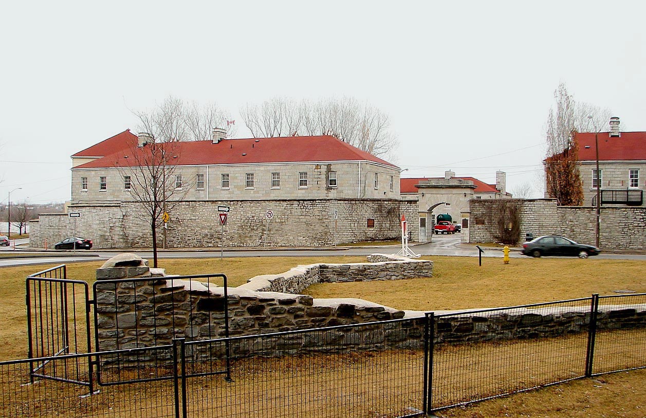
After British imperial forces withdrew from most Canadian locations in 1870–71, the Canadian Militia authorized the creation of two batteries of garrison artillery which provided garrison duties and schools of gunnery. "A " Battery School of Gunnery was established at Tête-de-Pont Barracks and other locations in Kingston ("B " Battery was located in Quebec). These batteries were known as the Regiment of Canadian Artillery. When this regiment evolved into the Royal Canadian Horse Artillery (RCHA), its headquarters was at the Tête-de-Pont Barracks from 1905 to 1939. When the RCHA left for operational duties during the Second World War, the fort was used as a personnel depot.

On 25 May 1923, the site of Fort Frontenac was designated as a National Historic Site of Canada.

In 1939 the site of the fort again became known as Fort Frontenac. Canadian Army staff training began at Fort Frontenac when the Canadian Army Staff College moved to the fort from the Royal Military College in 1948. The college is now known as the Canadian Army Command and Staff College. Fort Frontenac was also the location of the National Defence College until 1994.

Archaeology

[edit]

In 1982, archaeological investigation began at the fort. In early 1984, the City of Kingston redesigned the intersection of Ontario and Place d'Armes Streets so that the northwest bastion (Bastion St. Michel) and curtain wall could be excavated and partially reconstructed. The research also provided important details about the development and use of the fort and surrounding area, and helped to establish the relationship between the physical remains and the information included in historical maps and plans.[24]

Intact remains of the east bastion were located in 2020 by archaeologists while preparing for infrastructure work. Deposits associated with the fur trade era were found on the south side of the bastion wall, including trade beads, beaver jaws, gun flints, and fish bones.[25]

See also

[edit]

Footnotes

[edit]

References

[edit]
[edit]
Revisions and contributorsEdit on WikipediaRead on Wikipedia
from Grokipedia
Fort Frontenac was a French trading post and military fort built in July 1673 at the mouth of the Cataraqui River, where Lake Ontario meets the St. Lawrence River, in present-day Kingston, Ontario, by Louis de Buade de Frontenac, Governor of New France.[1][2] The fort's primary purposes included securing French dominance in the fur trade by controlling access to the Great Lakes basin and shielding allied Indigenous nations from Iroquois raids.[3][2] Temporarily abandoned amid conflicts, it was rebuilt in 1695 and reinforced over subsequent decades.[1] In August 1758, during the Seven Years' War, British forces led by Lieutenant Colonel John Bradstreet captured the fort in a surprise raid, a pivotal victory that disrupted French supply lines and supply communication in the region.[4][5] Under British control, Fort Frontenac functioned as a key garrison during the American Revolutionary War and the War of 1812, after which it transitioned to peacetime uses.[6] Today, the site hosts the Canadian Army Command and Staff College, encompasses archaeological remains recognized as a National Historic Site of Canada, and features ongoing preservation efforts of its structures.[7][8]

Geography and Strategic Importance

Location and Physical Features

Fort Frontenac occupies a strategic position at the mouth of the Cataraqui River on the northern shore of Lake Ontario, in present-day Kingston, Ontario, Canada.[7][9] This location marks the western bank where the Cataraqui River flows into Lake Ontario, providing direct access to the lake's eastern outlet toward the St. Lawrence River.[10] The site's coordinates place it approximately at 44°13′57″N 76°29′10″W, situated on flat, low-lying terrain suitable for fortification and harboring vessels.[11] The physical features of the area include a natural harbor formed by the river mouth, which offered sheltered waters for ships and canoes, essential for controlling maritime traffic between the Great Lakes and the Atlantic via the St. Lawrence system.[8] Surrounding the site is the broader Kingston Peninsula, characterized by limestone bedrock of the Frontenac Arch geological formation, contributing to stable ground for construction amid the otherwise marshy riverine environment.[4] The terrain rises gently inland, allowing defensive visibility over the lake and river approaches while facilitating portage routes to inland waterways.[6] Today, the fort's remnants form an archaeological site buried beneath urban development, including the intersection of Ontario Street and Place d'Armes, with no above-ground structures from the original French period visible, underscoring the site's transformation from a waterfront bastion to a subsurface historic layer.[7][6]

Role in Trade Routes and Military Defense

Fort Frontenac's location at the confluence of the Cataraqui River and Lake Ontario, where the lake meets the St. Lawrence River, positioned it as a critical gateway controlling access to fur trade routes in the Great Lakes Basin and Canadian Shield.[7] Constructed in 1673 by Louis de Baude, Comte de Frontenac, the fort aimed to counter English competition from New York by securing French dominance over Iroquois-influenced trade paths and enabling direct commerce with western Indigenous nations.[8] This strategic site served as a primary transit hub linking Montreal to Detroit and the Ohio Valley, facilitating the transport of furs and goods while bypassing hostile territories.[12] Shipbuilding at Cataraqui Harbour enhanced the fort's trade role, with the first vessels launched in 1675 under Robert Cavelier, Sieur de La Salle, allowing navigation across Lake Ontario to support expeditions and commercial exchanges into the Mississippi and Ohio River valleys.[7][8] By 1741, two small ships-of-war were constructed to protect trade traffic, underscoring the fort's integration of economic and defensive functions on the lake.[8] These maritime capabilities enabled the movement of trade goods, supplies, and personnel, solidifying Fort Frontenac's centrality in New France's western expansion.[8] Militarily, the fort functioned as a key outpost defending against Iroquois incursions and British advances, with vessels from its harbor patrolling Lake Ontario and supporting raids on Iroquois communities in northern New York following its 1695 reconstruction.[8][7] Reinforced with limestone walls and bastions, it protected French colonial interests during 17th-century conflicts and served as a base for regulating regional traffic against Indigenous and European rivals.[12][7] During the Seven Years' War, French forces used the fort's naval assets to drive British ships from Lake Ontario on June 27, 1756, but its capture by Colonel John Bradstreet's British expedition on August 27, 1758, severed vital supply lines to Fort Niagara, marking a turning point in the conflict.[8][7]

Establishment and French Colonial Period

Founding by Frontenac in 1673

In 1673, Louis de Buade, Comte de Frontenac, the Governor of New France, ordered the construction of a fort at the mouth of the Cataraqui River where it meets Lake Ontario, establishing it as a strategic outpost to expand French influence westward and intercept furs traded by Indigenous groups to English and Dutch merchants via Iroquois intermediaries.[13][14] Frontenac contravened official French policy against westward expansion beyond the Great Lakes to prioritize fur trade profits, viewing the site—known to the French as Cataracoui—as key to controlling Lake Ontario access and countering Iroquois dominance in regional commerce.[14][9] On July 12, 1673, Frontenac arrived at the location with an expedition of soldiers and canoes, convening a council with Iroquois delegates from the Onondaga and other nations to negotiate peace and alliance terms while construction commenced immediately on a wooden palisaded structure.[6][15] The fort, initially named Fort Cataraqui after the river, consisted of basic fortifications including stockades and barracks, manned by a small garrison to facilitate trade and military operations.[16][3] This establishment marked the first permanent European presence at the site, later renamed Fort Frontenac in honor of its founder, and served dual purposes as a commercial hub for exchanging European goods for pelts and a defensive position against potential Iroquois hostilities.[1][8] René-Robert Cavelier, Sieur de La Salle, acted as Frontenac's emissary during the founding negotiations and contributed to early oversight, though Frontenac directed the initiative to bolster New France's economic and territorial claims amid competition with British colonies.[15] The fort's placement exploited natural features like the river's sheltered harbor for canoe fleets, enabling efficient transport along the St. Lawrence and Lake Ontario trade routes essential for the beaver fur economy.[9] By autumn 1673, the outpost was operational, hosting initial trade gatherings and demonstrating French intent to integrate the upper Great Lakes into their colonial network despite logistical challenges from distance and supply lines.[3]

Early Operations and Fur Trade Dominance

Fort Frontenac, initially constructed as a wooden palisade fort with earthworks and log buildings in July 1673, served primarily as a military outpost to deter Iroquois raids on French-allied tribes and secure trade routes along the northern shore of Lake Ontario.[8][3] Under the command of Robert Cavelier, Sieur de La Salle, the fort functioned as a base for expeditions, including the launch of the first French ships on Lake Ontario from Cataraqui Harbour in 1675, which facilitated the transport of trade goods and supplies upstream.[8] These operations extended French influence westward, enabling direct alliances with Ottawa, Ojibwe, and other Indigenous nations essential for military support and fur procurement.[13] The fort's strategic location allowed France to dominate the fur trade by intercepting pelts from the Great Lakes basin before they reached Iroquois intermediaries trading with English and Dutch merchants in Albany.[17][13] In 1675, Frontenac leased the site to La Salle as a seigneury for an annual payment of 3,000 livres, granting him a monopoly on fur trading south of the Great Lakes and prompting La Salle to rebuild the fortifications with stone walls and bastions.[17][8] Fleets of canoes operated by coureurs de bois and Native allies transported furs safely to Montreal, bypassing Montreal-based merchants who opposed the outpost for undermining their control over western trade routes.[3][17] This direct access to upper-country supplies strengthened French economic leverage, contributing to a period of relative peace and prosperity in New France from 1673 to 1681.[3] As an entrepôt, Fort Frontenac handled local trade along Lake Ontario's shores while supporting broader supply lines to interior posts, ensuring a steady flow of beaver and other pelts critical to New France's economy.[13] The outpost's success in fostering Indigenous partnerships and challenging British competition solidified French preeminence in the regional fur market during its initial years, though it provoked resistance from established colonial traders who viewed it as an unauthorized extension of gubernatorial power.[17][13]

Conflicts and Fortifications

Iroquois Siege and Temporary Abandonment in 1689

In retaliation for Governor Denonville's 1687 military expedition against the Seneca, an Iroquois nation, the Haudenosaunee Confederacy intensified hostilities against French outposts in New France.[18] Following the Lachine massacre on August 5, 1689, where approximately 1,500 Iroquois warriors raided settlements near Montreal, killing over 24 colonists and capturing others, the Iroquois extended their offensive to isolate remote French positions. Fort Frontenac, garrisoned by a small force of around 100-150 men under commanders such as Jordan de Requescure, faced constant harassment and blockade on Lake Ontario, preventing supply convoys from reaching the outpost and effectively besieging it without direct assault.[19] This pressure, combined with the broader Anglo-Iroquois alliance amid King William's War, severed the fort's logistical lifelines from Quebec.[20] The prolonged isolation led to severe hardships within the fort. Lacking fresh provisions, the garrison succumbed to scurvy, with historical records indicating the loss of up to 93 men primarily to the disease rather than combat, drastically reducing defensive capabilities.[21] Iroquois warriors maintained vigilance around the site, launching intermittent raids on surrounding areas and fisheries, further exacerbating food shortages and morale collapse.[19] Attempts to reinforce or resupply the fort failed due to the ongoing threats, leaving the outpost untenable amid the wider Iroquois campaign that also targeted Fort Niagara.[22] By late 1689, with the garrison weakened and resupply impossible, Denonville ordered the evacuation and partial destruction of Fort Frontenac to prevent its use by the Iroquois.[18] The French burned structures and stores before withdrawing the survivors to Montreal, abandoning the strategic Lake Ontario position temporarily.[22] This decision reflected the fort's vulnerability as an overextended outpost, too distant for effective defense without substantial reinforcements, allowing Iroquois forces to occupy the ruins briefly.[7] The site remained unoccupied by Europeans until reconstruction efforts in 1695, marking a six-year interlude in French control.[21]

Reconstruction under La Salle in 1695

Following the Iroquois destruction and French abandonment of Fort Frontenac in 1689 amid King William's War, the site remained unoccupied for six years, its strategic value on Lake Ontario diminished by ongoing hostilities with the Iroquois Confederacy.[9] In July 1695, Governor Louis de Buade, Comte de Frontenac, ordered the fort's reconstruction and reoccupation to reassert French control over western trade routes and counter Iroquois influence, dispatching a mixed force of approximately 700 men comprising colonial troops (Troupes de la Marine), Canadian habitants, and Indigenous allies.[13] This expedition, despite internal debates questioning the expense amid resource constraints, prioritized rapid fortification to serve as a launch point for fur trade operations and military campaigns into the Great Lakes interior.[21] The reconstruction effort focused on practical, expedited defenses rather than elaborate new builds, leveraging remnants of the earlier stone structures originally enhanced under earlier commandants like Robert Cavelier de La Salle in the 1670s and 1680s. Workers repaired masonry walls using crushed remnants of prior mortar mixed with clay as a substitute binder, forgoing lime production due to time pressures, while felling timber for barracks and erecting a new 12-foot-high masonry block adjacent to the existing north curtain wall, which formed one side of the enclosure.[13] These measures restored basic habitability and defensive capability for a small garrison, enabling the post—formally renamed Fort Frontenac—to resume operations as a key node in France's North American network, facilitating alliances with western Indigenous groups against the Iroquois and English colonial expansion.[9] The rebuilt fort's immediate role emphasized economic and diplomatic functions over heavy fortification, with limited reinforcements arriving later under officers like François-Charles de Bourlamaque to bolster its viability until the mid-18th century. Archaeological evidence from later excavations corroborates the hasty, utilitarian nature of the 1695 works, distinguishing them from the more ambitious stone bastions of the 1670s.[13] This reoccupation marked a tactical resurgence in French colonial strategy, though the site's isolation continued to challenge sustained logistics and supply.[8]

Capture by British Forces in 1758

Following the British failure at the Battle of Carillon on July 8, 1758, Lieutenant Colonel John Bradstreet, serving as a quartermaster general, secured permission from General James Abercrombie to launch a raid on Fort Frontenac to disrupt French logistics on Lake Ontario.[23] Bradstreet assembled a force of approximately 3,000 men, comprising provincial militia from New York and New England alongside a small contingent of British regulars, along with bateaux for transport and light artillery.[5] The expedition departed from the ruins of Fort Oswego, crossed Lake Ontario, and arrived in sight of the fort by August 25 after navigating challenging riverine routes.[24] The French garrison at Fort Frontenac, numbering fewer than 110 regulars and militia, faced insurmountable odds against the British assault. Bradstreet's troops encircled the fort, positioned artillery on higher ground, and bombarded the defenses, prompting a swift capitulation on August 27 without significant combat.[4] British casualties were minimal during the engagement itself, though the expedition had seen desertions en route totaling around 600 men. The victors seized substantial French supplies—including provisions, ammunition, and trade goods valued at over 800,000 livres—as well as nine vessels on the lake, before razing the fort's structures to prevent reuse.[4] This capture severed a critical French supply artery to outposts on the Great Lakes and Ohio Valley, such as Fort Niagara and Fort Duquesne, undermining New France's western defenses and bolstering British momentum in the campaign.[25] The raid exemplified early amphibious and riverine tactics that informed later operations, marking a pivotal shift in the French and Indian War by exposing vulnerabilities in French overextended lines.[5]

British Occupation and Evolution

Immediate Aftermath and Rebuilding Efforts

Following the surrender of the French garrison on August 27, 1758, Lieutenant Colonel John Bradstreet's force of approximately 3,000 provincial troops and Native American allies plundered the fort's stores, capturing or destroying 109 bateaux, nine schooners, and substantial supplies intended for western French posts.[5] [24] The British then systematically demolished and burned the fortifications, rendering the site unusable before retreating to Oswego by early September.[24] This raid severed key French supply lines across Lake Ontario, contributing to the abandonment of Fort Niagara later that year as Governor Pierre de Vaudreuil de Rigaud prioritized defending Quebec.[26] The ruins of Fort Frontenac remained unoccupied and neglected through the remainder of the Seven Years' War and the subsequent period under British sovereignty after the 1763 Treaty of Paris, as no permanent garrison was established amid ongoing frontier hostilities and logistical challenges.[9] British control of the region was nominal until the influx of Loyalist refugees following the American Revolution prompted renewed military interest in the Cataraqui River site for securing Upper Canada.[9] Rebuilding commenced in July 1783 when a company of the 70th Regiment under Major John Ross reoccupied the location, partly reconstructing defenses using surviving French-era remnants such as stone foundations and the main barrack block, which underwent initial modifications for British use.[8] [9] These efforts transformed the site into a forward base for troop deployments and naval operations on Lake Ontario, with temporary wooden structures erected alongside repairs to support Loyalist settlement and deter American incursions, though full fortification awaited later expansions like the adjacent Fort Henry.[8] The reused French barracks featured additions such as partitioned interiors and brick chimneys by the early 1780s, serving as quarters until circa 1816.[6]

19th-Century Military Use and Kingston's Growth

Following the War of 1812, Fort Frontenac transitioned from a frontline defensive position to primarily a barracks complex, as its strategic fortifications were rendered obsolete by advancements in naval and artillery capabilities. The site retained its role as a British military installation, housing troops and supporting logistics for Upper Canada. In 1821–1824, significant upgrades included the construction of stone barracks, the removal of remaining French-era structures, and the leveling of temporary wooden facilities to create a marshalling ground known as Place d’Armes.[8][27] Further modifications occurred in the 1830s, such as the demolition of a southeast bastion tower in 1832 and the addition of defensive elements including Martello towers and a market battery, extending military enhancements through 1871.[8] The fort's barracks, originally established in 1783 by Major John Ross on the ruins and renamed Tête-de-Pont Barracks in 1789, provided essential infrastructure for troop deployments and administrative functions.[8][27] By 1871, following Canadian Confederation, the site was transferred from British to Canadian control and repurposed to house the 'A' Battery of Garrison Artillery, marking the first permanent militia unit in the new dominion's forces.[28] This continuity of military occupation underscored the site's enduring tactical value at the Lake Ontario-St. Lawrence River confluence, even as primary defenses shifted to nearby Fort Henry, constructed in 1832–1834. The sustained British military presence at Fort Frontenac catalyzed Kingston's urban expansion in the early 19th century. Reoccupation in 1783 drew merchants and Loyalist settlers to the vicinity of the garrison, establishing the area's first civilian commercial nucleus amid restricted military lands preserved for defense.[8][27] The influx of soldiers, supplies, and capital during and after the War of 1812 triggered a 30-year economic surge from 1815 to 1845, transforming Kingston from a frontier outpost into Ontario's largest urban center by 1830.[8][27] Complementary infrastructure, such as the Rideau Canal in the 1830s, reinforced the city's role as a garrison hub, fostering population growth and trade while the fort's reserve lands shaped early spatial development by limiting unchecked civilian encroachment.[8]

Archaeological Research and Preservation

Major Excavations from 1982 Onward

In September 1982, the Cataraqui Archaeological Research Foundation (CARF) initiated an intensive program of archaeological and historical research at Fort Frontenac in Kingston, Ontario, as part of the Kingston Harbourfront Archaeological Project Phase II, focusing on test excavations to identify subsurface remains of the original French fortifications.[6][29] These efforts uncovered sections of antiquated limestone walls, including portions attributed to reconstructions by René-Robert Cavelier de La Salle in the late 17th century.[7] The project expanded in 1983–1985 with extended field seasons involving systematic trenching and excavation across the site (archaeological designation BbGc-8), targeting areas beneath modern military structures to map the fort's structural evolution from its 1673 founding through multiple rebuilds.[13][30] Over 16 weeks in one season alone, teams documented stratigraphic layers revealing palisades, bastions, and domestic features, with artifacts including ceramics, trade goods, and military hardware analyzed for chronological sequencing.[30] In 1987, during unrelated construction within the fort compound, an opportunistic excavation exposed 12 grave sites containing human remains, presumed to belong to 18th- or 19th-century soldiers or colonial inhabitants based on associated coffin hardware and burial positioning, prompting forensic and historical corroboration by Canadian Forces personnel.[8] Subsequent targeted digs, such as a 2020 investigation in an adjacent parking lot by local archaeologists, recovered artifacts like musket balls and pottery shards to contextualize urban development impacts on the site's periphery, though these were smaller in scale compared to the 1980s campaigns.[31]

Findings and Interpretations of Original Structures

Archaeological excavations at Fort Frontenac since 1982 have uncovered remnants of the original French structures dating to the 1670s, primarily beneath modern streets in Kingston, Ontario, confirming the site's evolution from a rudimentary wooden outpost to a more fortified enclosure. The initial 1673 construction under René-Robert Cavelier de La Salle consisted of a temporary log palisade enclosing two 46-foot-long buildings positioned opposite each other and a smaller 20-foot storehouse, built hastily in under a week using local timber. Evidence includes post trenches excavated 0.20-0.30 meters into bedrock, containing remnants of ten vertical wooden pales, interpreted as supports for this early perimeter defense aligned with contemporary accounts of its crude, provisional design.[13][1] By 1675, La Salle reinforced the fort with a sturdier palisade and introduced limestone elements, including foundation walls for a principal dwelling (logis) using irregular slabs bedded in lime mortar directly on bedrock in some sections and vertical slabs set in clay without mortar in others. Excavations in units such as 18W, 18X, and 19X revealed these foundations, indicating a shift toward durability amid ongoing fur trade operations and Iroquois threats. The layout formed a square enclosure approximately 97.5 feet between curtain walls at the bastions, with four corner projections featuring masonry revetments for artillery placement, as evidenced by limestone foundations 0.45-0.90 meters high and 0.70 meters wide in the northwest bastion (units 16T-19R). These features corroborate historical descriptions of the fort's adaptation for military use while serving as a trade hub.[13][2] Further discoveries include sections of the west curtain wall, constructed around 1680 with 60 cm thick limestone bonded by lime mortar, and the north curtain wall from circa 1686, which replaced the earlier palisade and incorporated a dry moat cut into bedrock. Interpretations posit these upgrades reflected escalating regional conflicts, transitioning from timber vulnerability to stone resilience using locally quarried limestone, though resource shortages later prompted repairs with crushed mortar mixed in clay by 1695. The northwest bastion (Bastion St. Michel), excavated 1983-1985, yielded structural pits with charcoal, wood, and mortar, alongside associated barracks and trade stores, suggesting multifunctional use for storage and quarters within the original footprint. Overall, these findings validate archival plans from 1685 depicting partial stone fortifications amid wooden elements, underscoring the fort's role as a strategic pivot for French expansion into the Great Lakes without evidence of prior Indigenous occupation altering the site.[13][6][2]

Legacy and Modern Significance

Contributions to European Expansion in North America

Fort Frontenac, constructed in 1673 under the direction of Governor Louis de Buade de Frontenac with assistance from René-Robert Cavelier, Sieur de La Salle, served as a pivotal outpost for French commercial and territorial ambitions in the interior of North America.[32] Positioned at the northeastern outlet of Lake Ontario where the Cataraqui River meets the lake, the fort controlled access to the lucrative fur trade networks of the Great Lakes Basin and Canadian Shield, enabling the French to circumvent Iroquois intermediaries who previously dominated exchanges with western Indigenous groups.[1] By directing pelts toward Montreal markets, it bolstered New France's economy and reduced English colonial traders' infiltration from Albany.[33] The fort functioned as a launch point for exploratory ventures that extended French influence deep into the continent. In 1678, La Salle, granted seigneurial rights over Fort Frontenac by King Louis XIV along with authorization to probe western waterways, departed from there to construct the Griffon, the first European sailing vessel on the upper Great Lakes, facilitating transport of furs and supplies to distant posts. This expedition aimed to forge direct alliances with tribes like the Illinois and explore routes potentially linking to the Mississippi River, advancing French claims over territories rivaling British and Spanish holdings.[34] Subsequent supply lines from Frontenac supported inland forts such as Michilimackinac, sustaining missionary efforts, trade depots, and military presence amid competition with the Iroquois Confederacy. Through its role in securing trade dominance and enabling westward probes, Fort Frontenac contributed to the French strategy of linear penetration via rivers and lakes, contrasting with denser British coastal settlements and yielding nominal sovereignty over vast mid-continental regions until the 1763 Treaty of Paris.[35] It exemplified the outpost system's efficacy in projecting power with minimal population, prioritizing alliances with Indigenous nations for intelligence and logistics over large-scale colonization.[13] This approach temporarily checked Anglo-American expansion eastward from the Ohio Valley while fostering economic interdependence that funded further ventures.[36]

Current Status as Military Installation and Historic Site

The modern Fort Frontenac Garrison in Kingston, Ontario, continues to function as an active Canadian Armed Forces installation, primarily housing the Canadian Army Command and Staff College (CACSC), which provides professional military education to officers. Established at the site in 1947 following its use for Second World War training, the CACSC focuses on strategic studies, leadership development, and joint operations training, reflecting the fort's enduring role in Canadian military doctrine.[8][37] As a designated National Historic Site of Canada since 1951, the garrison overlays remnants of the original 17th- and 18th-century fortifications, including archaeological layers beneath contemporary structures like the Bradstreet Block and Vincent Block, which commemorate British colonial expansions and wartime logistics. Parks Canada recognizes the site's dual significance for its contributions to early European settlement and defense strategies, though public access is limited due to ongoing military operations, with guided tours occasionally available through coordinated heritage programs.[7][38] Preservation efforts integrate military use with heritage management, including restrictions on development to protect subsurface artifacts from the French and British eras, as evidenced by archaeological monitoring since the 1980s. The site's strategic waterfront position at the Cataraqui River's outlet into Lake Ontario underscores its historical and operational continuity, though no major expansions or closures have been reported as of 2025.[1][8]

References

User Avatar
No comments yet.