
Community hub
0 subscribers8 pages, 0 posts
Recent from talks
All channels
Be the first to start a discussion here.
Be the first to start a discussion here.
Be the first to start a discussion here.
Be the first to start a discussion here.
Contribute something
Welcome to the community hub built to collect knowledge and have discussions related to List of cities in Chile.
Nothing was collected or created yet.
List of cities in Chile
View on Wikipediafrom Wikipedia

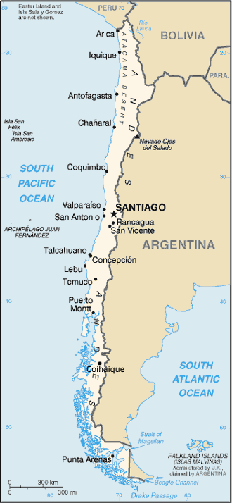
This is a list of cities in Chile.
A city is defined by Chile's National Statistics Institute (INE) as an "urban entity"[note 1] with more than 5,000 inhabitants. This list is based on a June 2005 report by the INE based on the 2002 census which registered 239 cities across the country.[1]
Complete list of cities by region
[edit]| Region | City | Population (2017 census) |
Population (2002 census) |
Area (km2) |
Density (/km2) |
|---|---|---|---|---|---|
| Arica | 221,364 | 175,441 | 41.89 | 4,188 | |
| Iquique | 191,468 | 164,396 | 22.12 | 7,432 | |
| Tarapacá | Alto Hospicio | 108,375 | 50,190 | 17.45 | 2,876 |
| Tarapacá | Pozo Almonte | 15,711 | 6,384 | 3.05 | 2,093 |
| Antofagasta | 361,873 | 285,255 | 43.54 | 6,552 | |
| Antofagasta | Calama | 165,371 | 126,135 | 18.21 | 6,927 |
| Antofagasta | Tocopilla | 25,186 | 23,352 | 7.00 | 3,336 |
| Antofagasta | Chuquicamata | 0 | 10,465 | 4.70 | 2,227 |
| Antofagasta | Taltal | 13,317 | 9,564 | 3.45 | 2,772 |
| Antofagasta | Estación Zaldívar | 9,053 | 0.12 | 75,442 | |
| Antofagasta | Mejillones | 13,467 | 7,825 | 4.67 | 1,676 |
| Antofagasta | María Elena | 6,457 | 7,412 | 1.52 | 4,876 |
| Copiapó | 174,309 | 125,983 | 47.77 | 2,637 | |
| Atacama | Vallenar | 51,917 | 43,750 | 13.91 | 3,145 |
| Atacama | Caldera | 17,662 | 12,776 | 8.48 | 1,507 |
| Atacama | Chañaral | 12,219 | 12,086 | 7.34 | 1,647 |
| Atacama | El Salvador | 8,697 | 3.35 | 2,596 | |
| Atacama | Tierra Amarilla | 14,019 | 8,578 | 13.48 | 636 |
| Atacama | Diego de Almagro | 13,925 | 7,951 | 4.05 | 1,963 |
| Atacama | Huasco | 10,149 | 6,445 | 2.73 | 2,361 |
| Coquimbo | 256,735 | 148,438 | 41.82 | 3,549 | |
| Coquimbo | La Serena | 249,656 | 147,815 | 65.59 | 2,254 |
| Coquimbo | Ovalle | 121,269 | 66,405 | 11.46 | 5,795 |
| Coquimbo | Illapel | 21,826 | 7.39 | 2,953 | |
| Coquimbo | Vicuña | 29,721 | 12,910 | 4.68 | 2,759 |
| Coquimbo | Salamanca | 29,110 | 11,615 | 4.37 | 2,658 |
| Coquimbo | Los Vilos | 23,374 | 10,966 | 4.11 | 2,668 |
| Coquimbo | Andacollo | 11,044 | 9,444 | 3.34 | 2,828 |
| Coquimbo | Combarbalá | 13,322 | 5,494 | 2.20 | 2,497 |
| Coquimbo | El Palqui | 6,175 | 5,266 | 1.36 | 3,872 |
| Coquimbo | Monte Patria | 30,751 | 5,219 | 2.35 | 2,221 |
| Viña del Mar | 334,248 | 286,931 | 87.33 | 3,286 | |
| Valparaíso | Valparaíso | 296,655 | 263,499 | 47.33 | 5,567 |
| Valparaíso | Quilpué | 151,708 | 126,893 | 38.06 | 3,334 |
| Valparaíso | Villa Alemana | 126,548 | 94,802 | 31.26 | 3,033 |
| Valparaíso | San Antonio | 91,350 | 83,435 | 21.02 | 3,969 |
| Valparaíso | Quillota | 90,517 | 62,231 | 15.13 | 4,113 |
| Valparaíso | Los Andes | 66,708 | 55,127 | 16.42 | 3,357 |
| Valparaíso | San Felipe | 76,844 | 53,017 | 18.11 | 2,927 |
| Valparaíso | La Calera | 50,544 | 47,836 | 16.18 | 2,956 |
| Valparaíso | Limache | 46,121 | 34,948 | 18.63 | 1,876 |
| Valparaíso | Concón | 42,152 | 31,558 | 26.00 | 1,214 |
| Valparaíso | Quintero | 31,923 | 18,719 | 17.01 | 1,100 |
| Valparaíso | La Ligua | 35,390 | 17,048 | 5.18 | 3,291 |
| Valparaíso | Llay-Llay | 24,608 | 16,215 | 6.56 | 2,472 |
| Valparaíso | Cartagena | 22,738 | 15,302 | 14.05 | 1,089 |
| Valparaíso | Casablanca | 26,827 | 14,437 | 7.02 | 2,057 |
| Valparaíso | Cabildo | 19,388 | 11,287 | 4.68 | 2,412 |
| Valparaíso | Placilla de Peñuelas | 39,344 | 10,811 | 6.71 | 1,611 |
| Valparaíso | La Cruz | 22,098 | 10,611 | 14.03 | 756 |
| Valparaíso | Olmué | 17,516 | 10,379 | 19.07 | 544 |
| Valparaíso | El Melón | 9,729 | 5.68 | 1,713 | |
| Valparaíso | Nogales | 22,120 | 8,969 | 3.84 | 2,336 |
| Valparaíso | El Quisco | 15,955 | 8,931 | 16.02 | 557 |
| Valparaíso | Hijuelas | 17,988 | 8,196 | 7.81 | 1,049 |
| Valparaíso | San Esteban | 18,855 | 7,542 | 6.81 | 1,107 |
| Valparaíso | Putaendo | 16,754 | 7,214 | 7.68 | 939 |
| Valparaíso | Catemu | 13,998 | 6,706 | 3.45 | 1,944 |
| Valparaíso | Santa María | 15,241 | 6,443 | 6.10 | 1,056 |
| Valparaíso | Las Ventanas | 8,630 | 5,957 | 12.84 | 464 |
| Valparaíso | Algarrobo | 13,817 | 5,827 | 11.38 | 512 |
| Valparaíso | Rinconada | 10,207 | 5,727 | 13.51 | 424 |
| Valparaíso | Calle Larga[note 2] | 14,832 | 4,966 | 3.82 | 1,300 |
| Valparaíso | Santo Domingo[note 3] | 10,900 | 4,583 | 13.83 | 331 |
| Valparaíso | El Tabo[note 3] | 13,286 | 3,823 | 12.44 | 307 |
| Puente Alto | 568,106 | 492,603 | 63.73 | 7,730 | |
| Santiago Metropolitan | Maipú | 521,627 | 463,103 | 54.89 | 8,437 |
| Santiago Metropolitan | La Florida | 366,916 | 365,563 | 39.07 | 9,357 |
| Santiago Metropolitan | Las Condes | 294,838 | 249,893 | 99.17 | 2,520 |
| Santiago Metropolitan | San Bernardo | 301,313 | 237,708 | 51.61 | 4,606 |
| Santiago Metropolitan | Peñalolén | 241,599 | 216,060 | 54.41 | 3,971 |
| Santiago Metropolitan | Santiago | 7,123,891 | 4,657,000 | 23.20 | 8,655 |
| Santiago Metropolitan | Pudahuel | 240,819 | 192,258 | 17.92 | 10,729 |
| Santiago Metropolitan | La Pintana | 177,355 | 190,085 | 30.71 | 6,190 |
| Santiago Metropolitan | El Bosque | 162,505 | 175,594 | 14.31 | 12,271 |
| Santiago Metropolitan | Ñuñoa | 255,823 | 163,511 | 16.86 | 9,698 |
| Santiago Metropolitan | Cerro Navia | 139,604 | 148,312 | 11.00 | 13,483 |
| Santiago Metropolitan | Recoleta | 157,851 | 148,220 | 15.84 | 9,357 |
| Santiago Metropolitan | Renca | 147,151 | 133,518 | 24.00 | 5,563 |
| Santiago Metropolitan | Conchalí | 133,420 | 133,256 | 11.04 | 12,070 |
| Santiago Metropolitan | La Granja | 122,518 | 132,520 | 10.03 | 13,212 |
| Santiago Metropolitan | Estación Central | 148,730 | 130,394 | 14.43 | 9,036 |
| Santiago Metropolitan | Quilicura | 222,048 | 125,999 | 38.72 | 3,254 |
| Santiago Metropolitan | Providencia | 147,826 | 120,874 | 14.34 | 8,429 |
| Santiago Metropolitan | Pedro Aguirre Cerda | 106,257 | 114,560 | 8.91 | 12,857 |
| Santiago Metropolitan | Lo Espejo | 103,454 | 112,800 | 8.45 | 13,349 |
| Santiago Metropolitan | Macul | 123,420 | 112,535 | 12.85 | 8,758 |
| Santiago Metropolitan | Lo Prado | 100,771 | 104,316 | 6.55 | 15,926 |
| Santiago Metropolitan | Quinta Normal | 118,503 | 104,012 | 11.87 | 8,763 |
| Santiago Metropolitan | San Joaquín | 99,371 | 97,625 | 9.89 | 9,871 |
| Santiago Metropolitan | La Reina | 96,811 | 96,762 | 23.73 | 4,078 |
| Santiago Metropolitan | San Ramón | 86,770 | 94,906 | 6.37 | 14,899 |
| Santiago Metropolitan | La Cisterna | 95,652 | 85,118 | 10.04 | 8,478 |
| Santiago Metropolitan | Vitacura | 88,716 | 81,499 | 28.63 | 2,847 |
| Santiago Metropolitan | San Miguel | 114,641 | 78,872 | 9.71 | 8,123 |
| Santiago Metropolitan | Huechuraba | 103,962 | 74,070 | 21.20 | 3,494 |
| Santiago Metropolitan | Lo Barnechea | 109,778 | 72,278 | 54.83 | 1,318 |
| Santiago Metropolitan | Cerrillos | 85,026 | 71,906 | 16.61 | 4,329 |
| Santiago Metropolitan | Independencia | 105,437 | 65,479 | 7.42 | 8,825 |
| Santiago Metropolitan | Peñaflor | 95,420 | 63,209 | 15.56 | 4,062 |
| Santiago Metropolitan | Colina | 152,740 | 58,769 | 14.46 | 4,064 |
| Santiago Metropolitan | Melipilla | 133,232 | 53,522 | 10.63 | 5,035 |
| Santiago Metropolitan | Talagante | 77,899 | 49,957 | 10.68 | 4,678 |
| Santiago Metropolitan | Buin | 101,743 | 40,091 | 14.61 | 2,744 |
| Santiago Metropolitan | Padre Hurtado | 67,299 | 34,257 | 7.42 | 4,617 |
| Santiago Metropolitan | El Monte | 37,901 | 22,284 | 14.16 | 1,574 |
| Santiago Metropolitan | Paine | 76,659 | 19,620 | 6.01 | 3,265 |
| Santiago Metropolitan | Curacaví | 34,337 | 15,645 | 6.62 | 2,363 |
| Santiago Metropolitan | Lampa | 107,662 | 12,319 | 5.63 | 2,188 |
| Santiago Metropolitan | Isla de Maipo | 37,965 | 12,295 | 9.79 | 1,256 |
| Santiago Metropolitan | La Islita | 6,570 | 1.98 | 3,318 | |
| Santiago Metropolitan | Bajos de San Agustín | 6,511 | 2.68 | 2,429 | |
| Santiago Metropolitan | Hospital | 5,664 | 17.55 | 323 | |
| Santiago Metropolitan | Alto Jahuel | 7,859 | 5,415 | 1.74 | 3,112 |
| Santiago Metropolitan | San José de Maipo | 17,540 | 5,281 | 3.46 | 1,526 |
| Santiago Metropolitan | Tiltil | 20,268 | 5,168 | 2.40 | 2,153 |
| Santiago Metropolitan | Pirque[note 3] | 28,010 | 4,855 | 12.22 | 397 |
| O'Higgins | Rancagua | 241,774 | 206,971 | 50.36 | 4,110 |
| O'Higgins | San Fernando | 76,009 | 49,519 | 12.37 | 4,003 |
| O'Higgins | Rengo | 61,438 | 30,891 | 9.28 | 3,329 |
| O'Higgins | Machalí | 55,258 | 23,920 | 16.19 | 1,477 |
| O'Higgins | Graneros | 34,828 | 21,615 | 3.61 | 5,988 |
| O'Higgins | San Vicente de Tagua Tagua | 48,801 | 18,914 | 13.86 | 1,365 |
| O'Higgins | Santa Cruz | 39,540 | 18,603 | 8.26 | 2,252 |
| O'Higgins | Chimbarongo | 35,399 | 13,795 | 11.67 | 1,182 |
| O'Higgins | Mostazal | 25,343 | 12,037 | 3.49 | 3,449 |
| O'Higgins | Pichilemu | 16,394 | 9,027 | 9.70 | 931 |
| O'Higgins | Requínoa | 27,968 | 8,240 | 2.65 | 3,109 |
| O'Higgins | Lo Miranda | 11,095 | 8,188 | 9.17 | 893 |
| O'Higgins | Doñihue | 20,887 | 7,402 | 4.32 | 1,713 |
| O'Higgins | Peumo | 14,313 | 7,392 | 5.13 | 1,441 |
| O'Higgins | Nancagua | 17,833 | 6,846 | 2.26 | 3,029 |
| O'Higgins | Las Cabras | 24,640 | 6,190 | 2.77 | 2,235 |
| O'Higgins | Quinta de Tilcoco | 13,002 | 5,850 | 5.01 | 1,168 |
| O'Higgins | Gultro | 5,423 | 5,472 | 3.29 | 1,663 |
| O'Higgins | Codegua | 12,988 | 5,113 | 4.01 | 1,275 |
| O'Higgins | Palmilla[note 3] | 12,482 | 2,088 | 5.43 | 385 |
| Maule | Talca | 242,344 | 189,505 | 46.04 | 4,116 |
| Maule | Curicó | 149,530 | 93,447 | 20.50 | 4,558 |
| Maule | Linares | 93,602 | 65,133 | 16.16 | 4,031 |
| Maule | Constitución | 46,068 | 33,914 | 8.68 | 3,907 |
| Maule | Cauquenes | 40,441 | 30,771 | 13.40 | 2,296 |
| Maule | Molina | 45,976 | 27,203 | 8.50 | 3,200 |
| Maule | Parral | 41,637 | 26,397 | 7.85 | 3,363 |
| Maule | San Javier | 45,547 | 20,524 | 7.42 | 2,766 |
| Maule | San Clemente | 43,269 | 13,398 | 5.77 | 2,322 |
| Maule | Teno | 30,850 | 6,729 | 3.03 | 2,221 |
| Maule | Longaví | 30,534 | 6,206 | 2.71 | 2,290 |
| Maule | Villa Alegre | 16,221 | 5,456 | 3.96 | 1,378 |
| Maule | Hualañé | 9,657 | 5,198 | 2.64 | 1,969 |
| Biobío | Concepción | 220,746 | 212,003 | 55.95 | 3,789 |
| Biobío | Talcahuano | 158,038 | 161,692 | 50.65 | 3,192 |
| Biobío | Chillán | 184,739 | 146,701 | 33.41 | 4,391 |
| Biobío | Los Ángeles | 212,875 | 117,972 | 27.35 | 4,313 |
| Biobío | Coronel | 116,262 | 91,469 | 24.52 | 3,730 |
| Biobío | Hualpén | 96,109 | 85,928 | 19.48 | 4,411 |
| Biobío | Chiguayante | 90,068 | 81,238 | 33.97 | 2,391 |
| Biobío | San Pedro de la Paz | 131,808 | 80,159 | 49.09 | 1,633 |
| Biobío | Lota | 45,920 | 48,975 | 9.63 | 5,086 |
| Biobío | Penco | 49,371 | 45,361 | 12.01 | 3,777 |
| Biobío | Tomé | 58,076 | 41,198 | 10.44 | 3,946 |
| Biobío | Curanilahue | 33,701 | 30,126 | 5.46 | 5,518 |
| Biobío | San Carlos | 55,278 | 29,359 | 9.06 | 3,241 |
| Biobío | Mulchén | 30,836 | 21,819 | 4.49 | 4,859 |
| Biobío | Nacimiento | 27,752 | 20,884 | 10.88 | 1,919 |
| Biobío | Lebu | 26,927 | 20,838 | 4.92 | 4,235 |
| Biobío | Cañete | 36,448 | 19,839 | 8.99 | 2,207 |
| Biobío | Chillán Viejo | 32,166 | 18,827 | 7.62 | 2,471 |
| Biobío | Arauco | 38,274 | 16,291 | 6.96 | 2,341 |
| Biobío | La Laja | 32,541 | 16,288 | 6.77 | 2,406 |
| Biobío | Hualqui | 25,552 | 13,724 | 7.35 | 1,867 |
| Biobío | Los Álamos | 22,067 | 13,035 | 6.90 | 1,889 |
| Biobío | Cabrero | 30,229 | 11,947 | 3.31 | 3,609 |
| Biobío | Bulnes | 22,329 | 10,681 | 3.09 | 3,457 |
| Biobío | Coelemu | 16,704 | 9,845 | 3.54 | 2,781 |
| Biobío | Yungay | 18,296 | 9,288 | 4.16 | 2,233 |
| Biobío | Yumbel | 21,958 | 8,302 | 2.58 | 3,218 |
| Biobío | Quirihue | 12,076 | 7,952 | 2.23 | 3,566 |
| Biobío | Quillón | 18,247 | 7,285 | 4.15 | 1,755 |
| Biobío | Coihueco | 27,680 | 7,230 | 2.66 | 2,718 |
| Biobío | Santa Juana | 14,602 | 7,095 | 2.35 | 3,019 |
| Biobío | Santa Bárbara | 14,461 | 6,838 | 2.35 | 2,910 |
| Biobío | Huépil | 6,576 | 2.56 | 2,569 | |
| Biobío | Monte Águila | 6,090 | 1.91 | 3,188 | |
| Biobío | San Rosendo[note 3] | 3,644 | 3,249 | 2.22 | 1,464 |
| Araucanía | Temuco | 295,839 | 227,086 | 46.10 | 4,926 |
| Araucanía | Angol | 55,140 | 43,801 | 14.94 | 2,932 |
| Araucanía | Padre Las Casas | 79,019 | 33,697 | 7.13 | 4,726 |
| Araucanía | Villarrica | 57,466 | 27,408 | 8.13 | 3,371 |
| Araucanía | Victoria | 35,219 | 23,977 | 7.54 | 3,180 |
| Araucanía | Lautaro | 39,614 | 18,808 | 5.80 | 3,243 |
| Araucanía | Nueva Imperial | 33,273 | 14,980 | 3.01 | 4,977 |
| Araucanía | Collipulli | 25,681 | 14,240 | 4.30 | 3,312 |
| Araucanía | Loncoche | 24,571 | 14,191 | 6.54 | 2,170 |
| Araucanía | Traiguén | 19,275 | 14,140 | 4.92 | 2,874 |
| Araucanía | Pucón | 28,796 | 13,750 | 9.53 | 1,443 |
| Araucanía | Pitrufquén | 25,549 | 13,420 | 3.90 | 3,441 |
| Araucanía | Curacautín | 18,054 | 12,412 | 4.58 | 2,710 |
| Araucanía | Carahue | 25,369 | 9,459 | 2.45 | 3,861 |
| Araucanía | Gorbea | 15,140 | 7,852 | 3.07 | 2,558 |
| Araucanía | Purén | 12,223 | 7,604 | 2.76 | 2,755 |
| Araucanía | Cunco | 17,992 | 7,316 | 1.95 | 3,752 |
| Araucanía | Labranza | 40,000 | 5,442 | 2.27 | 2,397 |
| Araucanía | Freire | 25,278 | 5,388 | 1.30 | 4,145 |
| Araucanía | Renaico | 10,634 | 5,355 | 1.67 | 3,207 |
| Los Ríos | Valdivia | 171,725 | 127,750 | 42.39 | 3,014 |
| Los Ríos | La Unión | 39,281 | 25,615 | 10.03 | 2,554 |
| Los Ríos | Río Bueno | 32,770 | 15,054 | 6.94 | 2,169 |
| Los Ríos | Panguipulli | 35,619 | 11,142 | 4.63 | 2,406 |
| Los Ríos | Paillaco | 20,575 | 9,973 | 2.78 | 3,587 |
| Los Ríos | Los Lagos | 20,430 | 9,479 | 5.40 | 1,755 |
| Los Ríos | Lanco | 17,264 | 7,817 | 2.56 | 3,054 |
| Los Ríos | Mariquina | 22,532 | 7,790 | 2.35 | 3,315 |
| Los Ríos | Futrono | 15,240 | 6,603 | 2.37 | 2,786 |
| Los Lagos | Puerto Montt | 245,902 | 153,118 | 39.58 | 3,869 |
| Los Lagos | Osorno | 170,129 | 132,245 | 31.82 | 4,156 |
| Los Lagos | Castro | 46,390 | 29,148 | 7.84 | 3,718 |
| Los Lagos | Ancud | 42,231 | 27,292 | 8.82 | 3,094 |
| Los Lagos | Puerto Varas | 46,283 | 22,022 | 9.26 | 2,378 |
| Los Lagos | Quellón | 28,499 | 13,656 | 3.21 | 4,254 |
| Los Lagos | Calbuco | 35,813 | 12,165 | 4.58 | 2,656 |
| Los Lagos | Purranque | 21,092 | 11,618 | 5.23 | 2,221 |
| Los Lagos | Llanquihue | 18,328 | 11,447 | 3.90 | 2,935 |
| Los Lagos | Frutillar | 19,649 | 9,118 | 4.11 | 2,218 |
| Los Lagos | Río Negro | 14,373 | 6,583 | 3.85 | 1,710 |
| Los Lagos | Fresia | 12,677 | 6,144 | 3.22 | 1,908 |
| Los Lagos | Los Muermos | 17,731 | 5,707 | 3.61 | 1,581 |
| Aysén | Coyhaique | 60,005 | 44,850 | 18.27 | 2,455 |
| Aysén | Puerto Aysén | 27,644 | 16,936 | 7.42 | 2,282 |
| Magallanes | Punta Arenas | 136,476 | 116,005 | 39.03 | 2,972 |
| Magallanes | Puerto Natales | 21,477 | 16,978 | 5.57 | 3,048 |
Largest urban agglomerations
[edit]This list includes conurbations, "absorptions" and cities with over 100,000 inhabitants, according to the 2017 census.
| Urban Entity | Region | Population (2017)[2] | |
|---|---|---|---|
| 1 | Greater Santiago | Metropolitana de Santiago | 6,139,087 |
| 2 | Greater Valparaíso | Valparaíso | 935,602 |
| 3 | Greater Concepción | Biobío | 719,944 |
| 4 | Greater La Serena | Coquimbo | 399,450 |
| 5 | Antofagasta | Antofagasta | 348,517 |
| 6 | Greater Temuco | Araucanía | 312,503 |
| 7 | Greater Iquique | Tarapacá | 293,068 |
| 8 | Greater Rancagua | O'Higgins | 290,029 |
| 9 | Puerto Montt and Puerto Varas | Los Lagos | 238,175 |
| 10 | Greater Talca | Maule | 236,347 |
| 11 | Arica | Arica y Parinacota | 202,131 |
| 12 | Greater Chillán | Ñuble | 191,629 |
| 13 | Calama | Antofagasta | 157,575 |
| 14 | Coronel and Lota | Biobío | 155,329 |
| 15 | Copiapó | Atacama | 150,804 |
| 16 | Valdivia | Los Ríos | 150,048 |
| 17 | Greater Quillota | Valparaíso | 149,159 |
| 18 | Osorno | Los Lagos | 147,666 |
| 19 | Los Ángeles | Biobío | 143,023 |
| 20 | Curicó | Maule | 125,275 |
| 21 | Punta Arenas | Magallanes | 123,403 |
| 22 | San Antonio | Valparaíso | 118,668 |
See also
[edit]Notes
[edit]- ^ An "urban entity" is defined by Chile's National Statistics Institute as a concentrated group of dwellings with over 2,000 inhabitants, or between 1,001 and 2,000 inhabitants if 50% or more of its population is economically active, dedicated to secondary and/or tertiary activities. Exceptionally, populated centers dedicated to tourism and recreation with over 250 concentrated dwellings and that do not meet the population requirement are considered urban.
- ^ Urban entity with less than 5,001 inhabitants, which is not part of a conurbation, yet still considered a city, possibly to account for census omission.
- ^ a b c d e Entity with 5,000 or less inhabitants that is part of a larger city from a neighboring commune.
References
[edit]- ^ Chile: Ciudades, Pueblos, Aldeas y Caseríos 2005, Instituto Nacional de Estadísticas – June 2005.
- ^ "Ciudades, Pueblos, Aldeas y Caseríos". Instituto Nacional de Estadísticas. Retrieved 25 April 2019.
Further reading
[edit]- Thomas A. Rumney (2013). "Chile: Urban Geography". Geography of South America: a Scholarly Guide and Bibliography. Scarecrow Press. ISBN 978-0-8108-8635-3.
External links
[edit]- National Statistics Institute (INE)
- Chile: Map of Largest Cities at the Wayback Machine (archived 2004-04-17)
List of cities in Chile
View on Grokipediafrom Grokipedia
Chile's cities vary widely in size and function: megacities like Santiago (metropolitan population ~7.4 million in 2024 preliminary) serve as political, economic, and cultural hubs, while port cities such as Valparaíso (~1 million as of 2024 est.) and Antofagasta (~466,000 as of 2024 est.) support international trade and mining exports.[5][6][7] Mid-sized centers like Concepción (~929,000 est.) and Temuco (~359,000 est.) anchor regional agriculture and forestry, and smaller cities in remote areas, such as those in Aysén or Magallanes regions, focus on tourism, fishing, and resource extraction.[8] The list often organizes cities by region or population rank, highlighting agglomerations where multiple comunas (municipalities) merge into larger urban areas, as seen in the Greater Valparaíso or Concepción metropolitan zones.[9] Urban growth in Chile has accelerated since the mid-20th century, with the population tripling between 1952 and 2017, largely due to internal migration and economic development. Challenges include seismic risks in a country prone to earthquakes, water scarcity in northern cities, and housing pressures in rapidly expanding areas like Puente Alto, a Santiago suburb with over 510,000 residents (est.).[8] Nonetheless, these cities embody Chile's progress, boasting high human development indices and contributing to the nation's status as one of Latin America's most urbanized and stable economies.
Introduction
Definition and Classification
In Chile, the legal framework defines cities primarily through the administrative division into communes (comunas), which serve as the basic territorial units for local governance under the Organic Constitutional Law of Municipalities (Ley Orgánica Constitucional de Municipalidades, No. 18.695). Urban communes, or comunas urbanas, are those characterized by continuous built-up areas, infrastructure development, and predominant urban land use, as outlined in the General Law of Urbanism and Constructions (Decreto con Fuerza de Ley No. 458). These entities are distinguished from rural communes by their degree of urbanization and population concentration, with cities often referring to the main urban nucleus within such communes.[10][11] Demographic thresholds for classifying settlements are established by the National Institute of Statistics (Instituto Nacional de Estadísticas, INE), which differentiates between cities (ciudades), towns (pueblos), villages (aldeas), and smaller hamlets (caseríos) based on population size and socioeconomic characteristics. A city is defined as an urban entity with more than 5,000 inhabitants, featuring continuous construction and high density. Towns range from 2,001 to 5,000 inhabitants, or 1,001 to 2,000 if less than 50% of the population is engaged in primary sector activities; villages encompass 301 to 2,000 inhabitants, or 1,001 to 2,000 with over 50% in primary activities, typically as concentrated rural settlements. These criteria ensure that classifications reflect both quantitative population metrics and qualitative urban-rural traits, such as access to services and economic structure.[12] Administratively, cities frequently function as capitals of provinces or regions, hosting key governmental institutions and serving as hubs for regional coordination and public services. For instance, Santiago, as the capital of the Metropolitan Region and the nation, exemplifies this role by concentrating executive, legislative, and judicial functions at multiple levels. This positioning underscores cities' importance in the decentralized structure outlined in the Regional Governments Law (Ley de Gobiernos Regionales, No. 19.175), where regional capitals facilitate policy implementation and intergovernmental collaboration.[13][14] The concept of the city in Chile traces its origins to the colonial era, when cabildos—municipal councils established by Spanish authorities—governed urban settlements, managing local affairs such as public works, justice, and community representation in places like Santiago and Concepción. Following independence in 1818, these evolved through constitutional reforms, transitioning to appointed mayors and departmental systems in the 19th century. The modern communal system was formalized by Decree Law No. 1.289 of 1976, which reorganized the territory into 346 communes to enhance local administration, and further refined by Law No. 18.695 in 1988, which granted municipalities autonomy in areas like education, health, and urban planning while maintaining national oversight.[15][11]Data Sources and Methodology
The primary data source for compiling lists of cities and their population figures in this article is the Instituto Nacional de Estadísticas (INE) of Chile, which conducts national censuses and produces official population projections.[16] The most recent census, conducted in 2024, enumerated a total population of 18,480,432 people, providing the baseline for urban and communal demographics.[17] Historical data draws from the 2017 census, which recorded 17,574,003 people, while population projections extend these figures forward, with updates released in July 2025 incorporating the 2024 census results and assumptions on fertility, mortality, and migration trends.[18][19] Cities included in this entry are selected based on criteria established by INE and aligned with national administrative classifications: urban entities with populations exceeding 5,000 inhabitants in designated urban areas, those holding status as communal capitals (cabeceras comunales), or officially recognized urban agglomerations by the Ministry of Housing and Urban Development (MINVU).[16][20] Rural localities below these thresholds, such as scattered settlements with fewer than 2,000 inhabitants or primarily agricultural character, are excluded to focus on urban centers.[21] Population figures prioritize urban agglomeration data (área urbana) over total communal totals to reflect city-specific densities, as defined by INE's cartographic and demographic standards.[16] Pre-2018 datasets do not separately account for the Ñuble Region, which was established in 2018 from portions of the former Bío Bío Region; however, INE has applied retroactive adjustments using 2017 census boundaries to isolate Ñuble's population at 480,609 for consistency in longitudinal analysis.[22] Post-2018 projections and the 2024 census integrate Ñuble as the 16th administrative region, ensuring comprehensive coverage.[18] INE's population projections employ the cohort-component method, reconciling census data with vital statistics and migration flows via the demographic balancing equation: , where is the final population, the initial population, and , , , represent births, deaths, immigration, and emigration over the interval.[23] For simpler inter-census estimates, an exponential growth approximation is sometimes used: , where is the population at time , the base population, and the annual growth rate derived from INE vital statistics.[18] Key limitations include potential underreporting in remote regions such as Aysén, where logistical challenges like isolation and harsh terrain led to difficulties in enumerating scattered populations during the 2024 census, resulting in a reported 2.4% population decline to 100,745 despite national growth trends.[24][25] Census figures may thus underestimate actual residency in such areas compared to projections, which assume stable migration patterns but cannot fully capture transient or informal settlements.[18]Cities by Region
Region 1: Arica y Parinacota
The Arica y Parinacota Region, known as Region 1, is Chile's northernmost administrative division, bordering Peru to the north and Bolivia to the east. It consists of two provinces—Arica and Parinacota—and four communes: Arica, Camarones, Putre, and General Lagos. The region spans approximately 16,873 square kilometers of arid desert and high Andean terrain, with a total population of 244,569 according to the 2024 census conducted by the Instituto Nacional de Estadísticas (INE).[26][27] Arica serves as the regional capital and primary urban center, a port city with a population of 241,653 in the 2024 census, facilitating trade and serving as a key border gateway to Peru via the Chacalluta crossing.[27] Putre, the capital of Parinacota Province, is a small high-altitude Andean town at about 3,500 meters elevation, with a population of 1,547 in 2024, known for its role as a base for exploring the surrounding altiplano. General Lagos is a predominantly rural commune without a major urban center, focusing on pastoral activities and with a population of 508 in 2024. Camarones, in Arica Province, is another rural area with limited urban development and a population of 861 in 2024, centered on coastal and valley communities.[27] Arica plays a vital role in international trade, particularly as the primary Chilean port for Bolivian exports and imports, supported by the Chungará Pass border crossing that connects to La Paz via the Andean highlands. The proximity of Lauca National Park, encompassing diverse ecosystems like high-altitude lakes and volcanoes within Parinacota Province, influences regional urban development by driving ecotourism while imposing environmental restrictions that limit expansion in sensitive highland areas.[28][29]| Commune | 2017 Census Population (INE) | 2024 Census Population (INE) |
|---|---|---|
| Arica | 221,364 | 241,653 |
| Camarones | 1,255 | 861 |
| Putre | 2,765 | 1,547 |
| General Lagos | 684 | 508 |
| Total | 226,068 | 244,569 |
Region 2: Tarapacá
The Tarapacá Region, designated as Region II in Chile's administrative divisions, encompasses two provinces—Iquique and Tamarugal—and seven communes, covering an area of approximately 42,226 square kilometers in the arid northern coastal zone. This mining-oriented region, historically tied to natural resource extraction, had a total population of 369,806 according to the 2024 national census conducted by the Instituto Nacional de Estadísticas (INE). Its urban centers reflect a blend of coastal trade hubs and inland desert settlements, with significant demographic growth driven by internal migration and cross-border inflows, particularly from neighboring Bolivia via the eastern border communes.[17][31][32] Iquique serves as the regional capital and primary urban center, functioning as a key free trade zone port that facilitates commerce between South America, Asia, and the Pacific markets, with the commune recording 199,587 residents in 2024. Adjacent to Iquique, Alto Hospicio has emerged as a rapidly expanding residential suburb, accommodating overflow population from the capital and reaching 115,927 inhabitants, supported by its proximity to employment opportunities in trade and services. Inland, Pozo Almonte stands out as a modest town of 13,456 people, originally established during the nitrate era and now centered on agriculture and small-scale mining in the Tamarugal Province.[17][33][34] The region's urban development bears the imprint of the late 19th- and early 20th-century nitrate boom, when vast pampas deposits fueled Chile's export economy, leading to the construction of railroads, worker settlements, and processing facilities that defined the layout of towns like Pozo Almonte and surrounding areas until synthetic alternatives caused industry decline in the 1930s. Additionally, Huara, with its 2,782 residents, functions as a critical waypoint for traversing the hyperarid Atacama Desert along Pan-American Highway 5 and Route 15, supporting logistics for mining operations and tourism to geoglyph sites like the Atacama Giant. Migration patterns, notably from Bolivia, have bolstered population in eastern communes such as Colchane (4,982 residents), where informal cross-border trade and labor mobility contribute to a diverse demographic, with immigrants comprising about 23% of the regional total.[35][36][37]| Commune | Province | Population (2024 Census) |
|---|---|---|
| Iquique | Iquique | 199,587 |
| Alto Hospicio | Iquique | 115,927 |
| Pozo Almonte | Tamarugal | 13,456 |
| Huara | Tamarugal | 2,782 |
| Pica | Tamarugal | 5,332 |
| Colchane | Tamarugal | 4,982 |
| Camiña | Tamarugal | 1,742 |
Region 3: Antofagasta
The Antofagasta Region, officially designated as Region III, is a northern administrative division of Chile characterized by its vast arid landscapes and heavy reliance on mining, particularly copper extraction. It encompasses three provinces—Antofagasta, El Loa, and Tocopilla—and nine communes, reflecting a sparse but strategically important population distribution shaped by industrial activities. According to the 2024 census from the Instituto Nacional de Estadísticas (INE), the region's total population is 635,416 inhabitants.[26] The region's urban centers are pivotal hubs for trade, energy, and mining operations, supporting Chile's position as a global leader in copper production. Antofagasta serves as the regional capital and a major port city, with a commune population of around 402,569 in recent estimates, facilitating exports of minerals and serving as a gateway for international commerce. Calama, located in the El Loa Province, is another key urban area with a commune population of approximately 166,000, acting as the primary base for operations at the nearby Chuquicamata mine, which attracts a transient workforce and boosts local demographics. Smaller ports like Mejillones, with a commune population of about 15,659, complement these by handling bulk cargo and supporting industrial logistics.[39][40][41] A defining feature of the region is the Chuquicamata mine near Calama, recognized as the world's largest open-pit copper mine by excavated volume, operational since 1910 and managed by Codelco, Chile's state-owned copper corporation. This site has profoundly influenced urban development in Calama, drawing migrant workers and contributing to population fluctuations. In Tocopilla, energy infrastructure stands out, including thermoelectric plants powered by coal and gas—such as the Tocopilla power station with units up to 400 MW—and emerging solar photovoltaic installations, like the 227 MW Tocopilla solar plant, which diversify the region's energy profile amid Chile's transition to renewables.[42][43][44] Mining activities, especially around Chuquicamata, lead to notable worker influx, with many residents being temporary or commuter laborers, inflating urban populations beyond permanent residents. The following table summarizes recent population estimates for key communes, distinguishing urban from total figures to illustrate this dynamic (data based on INE via BCN reports, aligned with 2024 census):| Commune | Urban Population (est.) | Total Commune Population (2024 est.) | Notes on Worker Influx |
|---|---|---|---|
| Antofagasta | 402,569 | 402,569 | Primarily urban; port activities attract logistics workers.[39] |
| Calama | 158,000 | 166,000 | Significant influx from Chuquicamata mine operations, with ~10% transient mining personnel.[40] |
| Mejillones | 10,500 | 15,659 | Port-related employment draws seasonal workers, increasing urban density.[41] |
| Tocopilla | 25,000 | 28,333 | Energy sector jobs contribute to modest urban growth.[45] |
Region 4: Atacama
The Atacama Region, designated as Region 4 of Chile, encompasses a hyper-arid landscape in the north-central part of the country, characterized by vast deserts and mineral-rich terrains. It is administratively divided into three provinces—Chañaral, Copiapó, and Huasco—and nine communes: Alto del Carmen, Caldera, Chañaral, Copiapó, Diego de Almagro, Freirina, Huasco, Tierra Amarilla, and Vallenar. The region's total population is 299,180 according to the 2024 census, reflecting modest growth influenced by mining activities.[26] Key urban centers in the region are dominated by mining economies, with Copiapó serving as the capital and primary hub. Copiapó, with a population of 175,240 in recent estimates, functions as a central mining center, supporting copper extraction and related industries that have sustained economic activity amid the desert environment. Chañaral, a smaller port city with around 11,500 residents in recent estimates, facilitates maritime access for mineral exports and local fisheries. Diego de Almagro, a copper-focused town with a population of 14,019, exemplifies the region's mining-dependent settlements, where operations at nearby sites like El Salvador mine drive community development. The Pan de Azúcar National Park, spanning parts of Chañaral Province, exerts a notable influence on local ecosystems and communities through its reliance on coastal fog (camanchaca) for vegetation, fostering unique biodiversity that supports ecotourism and protects endemic species near urban areas like Chañaral.[46] In contrast, Vallenar emerges as an agricultural oasis within the otherwise barren desert, enabled by the Huasco River's irrigation systems that enable cultivation of olives, citrus, and other fruits, sustaining a population of about 52,000 and providing a vital counterpoint to the dominant mining sector. Population data for major cities in the region account for growth driven by a copper mining boom, though recent trends show stabilization due to market fluctuations.[47]| City | Province | 2024 Population (est.) | Key Characteristics |
|---|---|---|---|
| Copiapó | Copiapó | 175,240 | Regional capital; major copper mining hub |
| Vallenar | Huasco | 52,000 | Agricultural oasis in Huasco Valley |
| Diego de Almagro | Chañaral | 14,019 | Copper mining community |
| Chañaral | Chañaral | 11,500 | Coastal port supporting exports |
Region 5: Coquimbo
The Coquimbo Region, designated as Region V in Chile's administrative divisions, occupies a semi-arid north-central position along the Pacific coast, featuring diverse landscapes from coastal plains to Andean valleys. It encompasses three provinces—Elqui, Limarí, and Choapa—subdivided into 15 communes, supporting a total population of 832,864 according to the 2024 census. This region plays a vital role in Chile's economy through agriculture in irrigated valleys, copper and iron mining in inland areas, and tourism drawn to its clear skies, beaches, and historical sites. Urban centers here reflect a blend of indigenous Huasco and Diaguita heritage with Spanish colonial influences, fostering growth in services and agribusiness.[26] Among the region's principal cities, La Serena serves as the capital and a major tourist destination, with its population reaching 263,144 in recent estimates. Renowned for its neoclassical architecture, including over 30 preserved churches, and proximity to sandy beaches like Avenida del Mar, La Serena attracts visitors for stargazing in nearby observatories and cultural festivals. Adjacent Coquimbo, the primary port city with an estimated 260,000 residents, functions as a commercial gateway for regional exports, particularly minerals and seafood, while hosting modern infrastructure such as the Cruz del Tercer Milenio monument overlooking the bay. Inland, Ovalle stands as an agricultural hub in the Limarí Province, home to about 123,724 people, where fruit orchards and vineyards thrive under irrigation from the Hurtado and Grande rivers, contributing to national table grape and avocado production. The Elqui Valley, within Elqui Province, exemplifies the region's viticultural potential, emerging as Chile's northernmost and commercially successful wine area since the 1990s, with high-altitude vineyards producing Syrah, Sauvignon Blanc, and Carmenère varietals suited to its intense sunlight and cool nights. This zone also leads in pisco distillation, a grape-based spirit central to Chilean heritage. Along the coast, Tongoy has developed into a prominent beach resort, featuring sheltered bays, hotel accommodations, and facilities for water sports, drawing seasonal tourists and supporting local fishing communities with improved infrastructure. Urban growth in Coquimbo has been steady, driven by tourism and mining investments, with the 2017 census recording 614,900 urban residents (81.2% of the regional total) compared to the 2024 census indicating continued expansion amid seasonal influxes from beachgoers and astro-tourists.| City (Commune) | 2017 Census Population | 2024 Projection | Annual Growth Rate (2017–2023) |
|---|---|---|---|
| La Serena | 198,199 | 263,144 | 2.0% |
| Coquimbo | 183,679 | 260,000 | 2.5% |
| Ovalle | 105,478 | 123,724 | 1.1% |
Region 6: Valparaíso
The Valparaíso Region, designated as Region V, constitutes a key central coastal administrative division in Chile, encompassing 8 provinces and 38 communes. With a population of 1,896,053 according to the 2024 census, it ranks as the country's second-most populous region after the Metropolitana de Santiago. This area blends urban coastal development with agricultural valleys, supporting industries such as shipping, wine production, and tourism.[26] Prominent cities in the region include Valparaíso, the capital and primary port city, which features a historic quarter recognized as a UNESCO World Heritage Site since 2003 for its 19th-century industrial architecture and funicular railways. Valparaíso has a population of 319,745 in recent estimates. Adjacent to it lies Viña del Mar, a renowned resort destination famous for its beaches, gardens, and annual song festival, with an estimated 369,303 inhabitants. Further inland, Quilpué serves as a growing commuter town, facilitating residential expansion for the nearby urban core and hosting a population of about 172,073. Valparaíso holds unique legislative significance as the seat of Chile's National Congress, established there in 1990 to decentralize governance from Santiago. The region's proximity to Aconcagua, the Americas' highest peak at 6,960 meters in the San Felipe de Aconcagua Province, bolsters adventure tourism, including mountaineering treks and visits to the surrounding Aconcagua Valley wine estates. High-density urban communes dominate the coastal strip, forming the Greater Valparaíso conurbation that integrates Valparaíso, Viña del Mar, Quilpué, and Villa Alemana into a continuous metropolitan area exceeding 1 million residents as of 2024. This urban agglomeration highlights the region's role as a vibrant economic corridor, with population densities surpassing 3,000 inhabitants per square kilometer in core areas like Viña del Mar.| City/Commune | Province | Population (2024 est.) | Density (inh/km², 2024) | Notes |
|---|---|---|---|---|
| Valparaíso | Valparaíso | 319,745 | 796 | Regional capital; UNESCO-listed historic port; legislative center. |
| Viña del Mar | Valparaíso | 369,303 | 3,037 | Premier resort city; high tourism density in coastal zones. |
| Quilpué | Marga Marga | 172,073 | 321 | Commuter hub; part of Greater Valparaíso conurbation. |
| Villa Alemana | Marga Marga | 169,622 | 1,424 | Residential satellite town; supports urban spillover. |
Region 7: Metropolitana de Santiago
The Región Metropolitana de Santiago, designated as Region 7 (RM), serves as the political, administrative, and economic hub of Chile. It is divided into 6 provinces—Chacabuco, Cordillera, Maipo, Melipilla, Santiago, and Talagante—and 52 communes, encompassing a mix of densely urbanized central areas and more expansive peripheral zones. According to the 2024 Census conducted by the Instituto Nacional de Estadísticas (INE), the region is home to 7,400,741 inhabitants, representing approximately 40% of Chile's total population.[48][49] Within this region, the dominant urban center is Santiago, the national capital, whose core commune in the Santiago province recorded 438,856 residents in the 2024 Census. The broader Santiago metropolitan agglomeration integrates most of the region's population, forming a cohesive urban expanse that drives national commerce, services, and infrastructure. Prominent peripheral cities include Puente Alto in the Cordillera province, the largest commune by population at 568,086 inhabitants, characterized by extensive residential neighborhoods and growing industrial activity; and Maipú in the Santiago province, with 503,635 residents, serving as a key industrial suburb with manufacturing hubs and agricultural heritage sites. Other notable urban communes, such as La Florida (374,836 residents) and Las Condes (around 300,000), contribute to the region's layered urban fabric, blending high-density housing with commercial districts.[50][51][52][53] The region functions as Chile's primary political and economic center, housing the presidential palace (La Moneda), the National Congress, the Supreme Court, and headquarters for major banks, multinational corporations, and stock exchanges that account for over 50% of the country's GDP. A defining landmark is Cerro San Cristóbal, an 880-meter hill integrated into the Parque Metropolitano, which offers sweeping vistas of the Andean backdrop and urban skyline, and serves as a vital green space and cultural icon since its designation as a public park in the early 20th century.[54][55][56] The table below summarizes 2024 Census population data for selected communes, highlighting the core Santiago area versus peripheral urban extensions:| Commune | Province | Population (2024) | Classification |
|---|---|---|---|
| Santiago | Santiago | 438,856 | Core urban center |
| Puente Alto | Cordillera | 568,086 | Peripheral urban |
| Maipú | Santiago | 503,635 | Peripheral urban |
| La Florida | Santiago | 374,836 | Peripheral urban |
| Providencia | Santiago | 142,079 | Core urban center |
Region 8: O'Higgins
The Libertador General Bernardo O'Higgins Region, commonly known as Region VI, occupies a central position in Chile, south of the Santiago Metropolitan Region, and serves as a key agricultural and industrial hub in the country's Central Valley. Established as one of Chile's 16 administrative divisions, it encompasses three provinces—Cachapoal, Colchagua, and Cardenal Caro—and is subdivided into 33 communes that span diverse landscapes from Andean foothills to coastal plains. With a total population of 987,228 according to the 2024 census, the region supports a mix of urban centers and rural communities, driven by agriculture, mining, and viticulture, while benefiting from proximity to Santiago that facilitates economic integration.[26] Rancagua, the regional capital in Cachapoal Province, stands as the largest city with a population of 272,290, functioning as a vital center for copper mining operations and the burgeoning wine industry. Rengo, also in Cachapoal, is a smaller agricultural town with approximately 65,318 residents, focusing on fruit orchards and livestock that underpin the local economy. Further south in Colchagua Province, San Fernando acts as a valley hub with a population of ~80,000, supporting trade, manufacturing, and access to surrounding farmlands. These cities exemplify the region's transition from rural traditions to modern commuter-influenced growth, with urban areas expanding due to daily workforce flows to Santiago.[58][59][60] The O'Higgins Region holds unique significance in Chile's cultural and economic landscape, particularly through the Cachapoal Valley's role in wine production, where vineyards yield premium reds like Cabernet Sauvignon and Carmenère, contributing to over 10% of national exports via ideal alluvial soils and Mediterranean climate. Historically, Rancagua marks the site of the 1814 Battle of Rancagua, a pivotal clash during the independence wars where Chilean patriots under Bernardo O'Higgins resisted Spanish forces, symbolizing resilience and now commemorated through monuments and annual events. Population dynamics reflect these ties, with steady growth in northern communes fueled by commuting patterns to Santiago's job market, enhancing regional connectivity but straining infrastructure.[61][62][63]| City | Province | Population (2024 est.) | Key Economic Role |
|---|---|---|---|
| Rancagua | Cachapoal | 272,290 | Mining and wine production center |
| Rengo | Cachapoal | 65,318 | Agricultural processing hub |
| San Fernando | Colchagua | ~80,000 | Valley trade and manufacturing |
Region 9: Maule
The Maule Region, designated as Region 9 in Chile's administrative divisions, encompasses four provinces—Talca, Curicó, Linares, and Cauquenes—and 30 communes, forming a key south-central territory focused on agriculture, viticulture, and forestry. The 2024 Census by the Instituto Nacional de Estadísticas (INE) reports a total population of 1,123,008 residents, representing about 6% of Chile's national total and reflecting steady growth driven by economic opportunities in its river valleys.[17][64][26] The region's landscape features the fertile valleys of the Maule and Mataquito rivers, which sustain extensive farming, including fruit orchards, grain production, and the renowned Maule wine valley, particularly around Curicó. Forestry plays a pivotal role in the economy, with 17% of Chile's planted forests located here, primarily radiata pine, supporting industries like timber processing and exports that generate significant employment.[65][66] The area also contends with environmental challenges, such as recurrent flooding from the Maule River, with major events in 1982 and June 2023 causing widespread evacuations, crop losses, and infrastructure damage in communes like Talca and Constitución due to heavy rainfall exceeding 100 mm in short periods.[67][68] The 2010 earthquake of magnitude 8.8, centered offshore near Maule, devastated the region, destroying over 76,000 homes and displacing hundreds of thousands, with epicenters affecting urban centers like Talca and Curicó. National reconstruction plans, including the 2010 Plan de Reconstrucción, invested billions in housing, infrastructure, and economic revitalization, enabling population recovery and urban expansion; by the 2024 Census, the region's populace had reached 1,123,008.[69][70] Prominent cities include Talca, the capital and a university hub; Curicó, a transportation and wine center; and Linares, an agricultural focal point. These urban areas anchor the region's development, with Talca hosting the University of Talca, a leading institution for agronomic and enological studies that supports local viticulture innovation.[71] Curicó stands as a rail junction on the Pan-American Highway, bolstering trade in wines and forest products, while Linares thrives on surrounding farmlands yielding apples, cherries, and wheat. Post-2010 recovery is illustrated in the population trends of these key cities, as shown in the table below, based on INE census data; growth rates of 5-7% since 2017 highlight resilient urban rebound amid reconstruction.| City | 2017 Census Population | 2024 Census Population | Growth (2017-2024) |
|---|---|---|---|
| Talca | 220,357 | 232,131 | +5.3% |
| Curicó | 149,136 | 159,968 | +7.2% |
| Linares | 93,602 | 96,744 | +3.4% |
Region 10: Ñuble
The Ñuble Region, designated as Region 10, was established on September 6, 2018, through the separation of its territory from the former Biobío Region, marking Chile's newest administrative division.[74] It encompasses three provinces—Diguillín, Itata, and Punilla—and 21 communes, spanning an area of 13,179 square kilometers focused on agriculture, education, and emerging urban development.[74] The region's total population is 512,289 according to the 2024 census, reflecting steady growth driven by rural-to-urban migration and agricultural opportunities.[26][75] Chillán serves as the regional capital and largest urban center, with a municipal population of 202,826, functioning as a key hub for markets, higher education institutions like the University of Chile's Chillán campus, and commercial activities supporting surrounding farmlands. Bulnes, located in Diguillín Province, has a population of 22,732 and developed historically as a railway junction town, facilitating transport for agricultural goods from the central valley. Quillón, also in Diguillín, is a smaller riverside settlement with 19,182 residents, noted for its proximity to the Ñuble River and role in local farming communities. The region experienced significant impacts from the 2010 Maule earthquake, which damaged infrastructure across multiple communes, prompting extensive reconstruction efforts that emphasized resilient building standards and community recovery programs.[76] These initiatives, supported by national government funding, rebuilt key facilities in Chillán and surrounding areas, enhancing seismic preparedness.[76] Additionally, the Ñuble River basin features established irrigation systems, such as the Ñuble River Irrigation System (ÑRIS), which distribute water to over 20,000 hectares of cropland, primarily for grains, fruits, and vineyards, sustaining the region's economy.[77] Population data for Ñuble's communes are derived from the 2017 national census, adjusted via official projections to account for the 2018 regional separation and subsequent demographic shifts; pre-2018 figures often aggregated Ñuble areas under Biobío statistics. Updated with 2024 census where available.| City | Province | Population (2024 est.) | Key Characteristics |
|---|---|---|---|
| Chillán | Diguillín | 202,826 | Capital; market, education, and trade center |
| Bulnes | Diguillín | 22,732 | Railway and agricultural transport hub |
| Quillón | Diguillín | 19,182 | Riverside farming locality |
Region 11: Biobío
The Biobío Region, officially designated as Region 11, is located in south-central Chile and was established in its current form following the 2018 creation of the Ñuble Region from the former larger Biobío administrative division. It comprises three provinces—Arauco, Biobío, and Concepción—and 29 communes, covering an area of approximately 23,890 km² with a total population of 1,613,059 according to the 2024 census. This region serves as a major industrial hub, particularly for forestry, paper production, and port activities, contributing significantly to Chile's economy through its coastal access and natural resources like the Biobío River.[78][26] Concepción, the regional capital and largest city, is a key urban center with a population of 239,443, predominantly urban at 234,332 residents, known for its role as a university hub hosting institutions like the University of Concepción and as a major port facilitating trade. Hualpén, an industrial suburb adjacent to Concepción, has a population of approximately 88,706 and features high urban density due to its proximity to manufacturing and shipping facilities along the Biobío River estuary. Los Ángeles, the capital of Biobío Province, serves as a gateway to the Nahuelbuta mountain range with a population of 222,593, supporting agriculture, forestry, and light industry while acting as a commercial node for surrounding rural areas.[79][80] The Greater Concepción metropolitan area, encompassing 11 communes including Concepción, Hualpén, Talcahuano, and San Pedro de la Paz, forms Chile's second-largest urban agglomeration with an estimated population of 985,034 in recent assessments, driving regional economic growth through integrated transport and industrial zones. This area experienced significant devastation from the 2010 Maule earthquake and subsequent tsunami, which affected coastal communes like Talcahuano and Concepción, leading to over 500 deaths in the region and prompting major reconstruction efforts focused on resilient infrastructure and coastal defenses. Urban density in Biobío Province highlights the region's concentration of population in key centers, with Los Ángeles exhibiting moderate density amid its role as a provincial hub.| City/Commune | 2024 Population | Urban Density (hab/km², approx.) | Key Characteristics |
|---|---|---|---|
| Los Ángeles | 222,593 | 1,200 | Forestry gateway, commercial center.[80][81] |
| Nacimiento | 32,776 | 150 | Agricultural and timber processing suburb. |
| Mulchén | 35,210 | 100 | Rural-urban mix, transport node. |
Region 12: Araucanía
The Araucanía Region, designated as Region 12 in Chile's administrative divisions, encompasses two provinces—Cautín and Malleco—and 32 communes, spanning approximately 31,842 square kilometers in the southern part of the country. With a population of 1,010,423 according to the 2024 census, the region features a mix of Andean highlands, volcanic terrains, and fertile valleys that support agriculture, forestry, and tourism as primary economic drivers. Its urban centers reflect a blend of indigenous heritage and modern development, particularly influenced by the Mapuche people, who constitute about 33.6% of the regional population and maintain strong cultural ties to the land.[26][82] Temuco serves as the regional capital and primary urban hub, with a municipal population of 308,175, functioning as a key commercial center for agricultural products, timber, and regional trade. The city hosts markets, educational institutions, and transportation links that connect it to Santiago and other southern areas, driving economic activity amid growing urbanization. Nearby, Villarrica, with a municipal population of 60,327, is a lakeside town on the western shore of Lake Villarrica, renowned for tourism centered on water sports, hiking, and scenic views of the surrounding Araucanía Lake District. Pucón, at 30,508 residents, operates as a premier volcanic resort destination, attracting visitors for adventure activities like skiing and hot spring soaks near the base of Villarrica Volcano.[83][84] The region's demographic profile is marked by a significant Mapuche presence, approximately 33.6% of residents, which underscores ongoing cultural preservation efforts alongside land rights discussions in rural areas. Villarrica Volcano, one of Chile's most active, stands at 2,847 meters and has shown increased seismic and fumarolic activity since 2023, including lava lake visibility and minor emissions, prompting periodic alerts from authorities. These natural features enhance the area's appeal for eco-tourism while highlighting geological risks. Data from Chile's Instituto Nacional de Estadísticas (INE) indicate persistent rural-to-urban migration trends in Araucanía, with urban populations growing by about 0.55% annually from 2017 to 2024, driven by employment opportunities in cities like Temuco and seasonal tourism in resort towns. This shift has concentrated over 70% of the regional population in urban areas, exacerbating rural depopulation in Mapuche communities.[85][86]| City/Commune | Province | 2024 Population Projection (Municipal) | Key Role |
|---|---|---|---|
| Temuco | Cautín | 308,175 | Regional capital and commercial hub |
| Villarrica | Cautín | 60,327 | Lake tourism center |
| Pucón | Cautín | 30,508 | Volcanic resort town |
Region 13: Los Ríos
The Los Ríos Region, designated as Region XIII, is a southern Chilean administrative division renowned for its humid climate, intricate network of rivers, and expansive temperate rainforests that support a vital forestry sector. Bordered by the Araucanía Region to the north, Los Lagos to the south, Argentina to the east, and the Pacific Ocean to the west, it encompasses two provinces—Valdivia and Ranco—and 12 communes, including Valdivia, La Unión, and Río Bueno. According to the 2024 Population and Housing Census conducted by the Instituto Nacional de Estadísticas (INE), the region has a total population of 398,230, reflecting modest growth from 389,271 in 2017 and indicating demographic stability amid increasing eco-tourism.[87][88][26] Forestry dominates the regional economy, with native and plantation forests covering over 60% of the land area, contributing to Chile's wood products exports while fostering sustainable practices in areas like the Valdivian Coastal Reserve. Agriculture, particularly in the fertile valleys along the Río Bueno and other waterways, complements this through dairy farming and crop production, though populations in urban centers remain steady as tourism—drawn to riverine landscapes—drives economic diversification without significant migration pressures.[89] Valdivia, the regional capital and largest city, recorded 170,043 residents in the 2024 census and functions as a key river port, facilitating trade and transportation along the Valdivia, Calle-Calle, and Cau-Cau rivers. It is also a prominent educational hub, hosting the University of Austral de Chile, which supports research in forestry and aquaculture. La Unión, with a population of 38,907, serves as the capital of Ranco Province and exemplifies the region's agricultural heritage, featuring expansive farmlands dedicated to grains, vegetables, and livestock that bolster local food security. Río Bueno, home to 33,363 inhabitants, stands out as a dairy production center, where cooperatives process milk into cheeses and other products essential to southern Chile's agroindustry.[88][90][91][92] A distinctive feature of the region is the popularity of Valdivia River cruises, which provide visitors with immersive tours of the waterways, showcasing wetlands, wildlife, and historic sites while promoting environmental awareness. Additionally, Valdivia carries the enduring legacy of the 1960 Great Chilean Earthquake, a magnitude 9.5 event centered near the city that caused widespread devastation, including tsunamis and landslides, but spurred resilient urban rebuilding and ongoing seismic research initiatives.[93]| City/Commune | Population (2024 Census) | Key Characteristics |
|---|---|---|
| Valdivia | 170,043 | River port, university center; stable growth with tourism influx |
| La Unión | 38,907 | Agricultural focus; steady rural-urban balance |
| Río Bueno | 33,363 | Dairy hub; modest population stability amid agro-exports |
Region 14: Los Lagos
The Los Lagos Region, designated as Region 14 in Chile's administrative divisions, encompasses four provinces—Chiloé, Llanquihue, Osorno, and Palena—and is subdivided into 30 communes.[94] According to the 2024 Census conducted by the Instituto Nacional de Estadísticas (INE), the region has a total population of 890,284 residents, reflecting a diverse landscape that includes mainland areas, lakes, and the oceanic Chiloé Archipelago. This region is renowned for its contributions to Chile's economy through fisheries, particularly salmon aquaculture, which dominates alongside forestry, agriculture, and tourism centered on its natural parks and coastal features. (Official government overview from Gobierno Regional de Los Lagos)[17][26] Key urban centers in the region include Puerto Montt, the regional capital and primary gateway port for southern Chile, with a population of 277,040 as per the 2024 INE Census; it serves as a hub for maritime trade and passenger ferries to Patagonia and the islands.[17] Osorno, located on the mainland with a population of 166,455 (2024 INE Census), is notable for its historical German immigrant heritage, evident in its architecture and annual cultural festivals that preserve 19th-century European influences.[17] Castro, the capital of Chiloé Province on the island archipelago, has 46,997 residents (2024 INE Census) and functions as a center for traditional wooden palafito (stilt house) communities and artisanal fishing.[17] The region features unique cultural and natural elements, such as the rich mythology of the Chiloé Archipelago, where indigenous Huilliche and Spanish colonial traditions blend to create legends of mythical beings like the Trauco (a forest dwarf seducer) and the Caleuche (a ghostly ship that sails at night), deeply embedded in local folklore and celebrated through storytelling and festivals.[95] Additionally, Vicente Pérez Rosales National Park, established in 1926 as Chile's first national park, spans 2,530 square kilometers of Andean landscapes, including the Osorno Volcano, Petrohué Falls, and Lake Todos los Santos, protecting temperate rainforests and supporting ecotourism activities like hiking and boating. Population distribution highlights disparities between mainland and island areas, with denser urban settlements on the continent compared to the more remote, lower-density island communes, influenced by geographic isolation and economic reliance on fisheries versus agriculture. The following table summarizes populations of select key cities from the 2024 INE Census, illustrating this contrast:| City | Province | Location | Population (2024) |
|---|---|---|---|
| Puerto Montt | Llanquihue | Mainland | 277,040 |
| Osorno | Osorno | Mainland | 166,455 |
| Castro | Chiloé | Island | 46,997 |
Region 15: Aysén
The Aysén Region, officially known as the Aysén del General Carlos Ibáñez del Campo Region and designated as Region XI in Chile's administrative divisions, encompasses a vast, remote expanse of Patagonia characterized by fjords, glaciers, and dense temperate rainforests. It is administratively divided into four provinces—Aysén, Capitán Prat, Coyhaique, and General Carrera—further subdivided into 10 communes, reflecting its sparse settlement pattern in one of Chile's largest territorial units at 108,494 square kilometers.[96] With a population of 100,745 according to the 2024 census, the region maintains an exceptionally low density of approximately 1 inhabitant per square kilometer, underscoring its isolation and reliance on natural resource-based economies such as eco-tourism and fisheries. This remoteness contributes to seasonal population fluctuations, particularly from tourism influxes, while official estimates from the Instituto Nacional de Estadísticas (INE) note potential undercounts in remote areas due to logistical challenges in data collection.[26][16] The region's urban centers are few and small, serving as hubs for regional administration, trade, and access to natural attractions. Coyhaique, the capital and largest city, functions as the primary administrative and economic center, with an urban population of 62,800, supporting services for surrounding rural communities amid the challenges of limited infrastructure. Puerto Aysén, located about 65 kilometers north of the capital, acts as a key port city with an estimated population of 27,000, facilitating maritime trade and aquaculture operations along the fjords. Further south, Chile Chico, a border town near Argentina with around 5,200 residents, relies on cross-border commerce and serves as a gateway to the General Carrera Province's steppe landscapes.[97] Eco-tourism drives much of the region's economy, drawing visitors to protected areas like Patagonia National Park, established in 2018 and spanning 304,528 hectares across the General Carrera and Capitán Prat provinces, where biodiversity conservation efforts highlight native species such as the huemul deer and Andean condor.[98] Fisheries, particularly salmon aquaculture, contribute significantly, with Aysén accounting for nearly 50% of Chile's national salmonid production, centered around ports like Puerto Chacabuco near Puerto Aysén.[99] Connectivity remains a persistent challenge, exemplified by the Carretera Austral, a 1,240-kilometer unpaved highway that links isolated communities but requires ferry crossings and faces seasonal weather disruptions, limiting year-round access for the roughly 100,000 residents it serves.| City/Commune | Province | 2024 Population | Key Role |
|---|---|---|---|
| Coyhaique | Coyhaique | 62,800 | Regional capital and administrative hub |
| Puerto Aysén | Aysén | 27,000 | Port for fisheries and tourism |
| Chile Chico | General Carrera | 5,200 | Border town and trade access point |
Region 16: Magallanes y la Antártica Chilena
The Region of Magallanes y la Antártica Chilena, officially designated as Region XVI, is Chile's southernmost and largest region by area, spanning approximately 132,297 square kilometers and encompassing four provinces—Última Esperanza, Magallanes, Tierra del Fuego, and Antártica Chilena—along with 10 communes. Its total population reached 166,537 according to the 2024 national census conducted by the Instituto Nacional de Estadísticas (INE).[100][26] The region's remote, subantarctic environment features harsh winds, low temperatures, and vast expanses of Patagonia, including islands, fjords, and the Strait of Magellan, supporting economies centered on ranching, fishing, mining, and increasingly ecotourism. Punta Arenas serves as the regional capital and primary urban hub, with a 2024 census population of 132,363, representing about 79.5% of the region's total inhabitants. Founded in 1848 as a penal colony and later a wool export port, it has evolved into a key gateway for tourism to Patagonia and Antarctic expeditions, bolstered by its strategic location on the Strait of Magellan, which facilitates maritime navigation between the Atlantic and Pacific Oceans since Ferdinand Magellan's 1520 voyage. The city's economy also relies on oil and gas support services, with a historic core featuring monuments like the Nao Victoria Museum commemorating early explorations.[100][101] Other notable settlements include Puerto Natales, the capital of Última Esperanza Province, with 24,152 residents in the 2024 census, acting as the main entry point to Torres del Paine National Park and drawing international visitors for hiking, glacier tours, and wildlife viewing in the surrounding fjords and mountains. Porvenir, on Isla Grande de Tierra del Fuego in Tierra del Fuego Province, has a population of 6,809 and functions as a ranching center with a significant military presence from the Chilean Army's base, supporting border security and research in the subantarctic ecosystem.[100] The region uniquely administers Chile's Antarctic Territory through Antártica Chilena Province, which claims sovereignty over 1,250,000 square kilometers of the continent south of 60°S latitude, managed from bases like Frei Station on King George Island for scientific research in glaciology, biology, and climate studies under the Antarctic Treaty System. Populations in remote communes such as Cabo de Hornos (Puerto Williams, 1,750 residents) and the Antártica commune (60 residents) are heavily influenced by military personnel, naval forces, and international researchers, contributing to transient demographics amid the permanent settlements. The Strait of Magellan's navigation remains vital for regional trade and cruise ships, handling over 1,000 vessels annually and underscoring the area's geopolitical and logistical importance.[100]| Commune | Province | 2024 Census Population | Key Characteristics |
|---|---|---|---|
| Punta Arenas | Magallanes | 132,363 | Regional capital; major port for tourism and wool; historic trade hub. |
| Puerto Natales | Última Esperanza | 24,152 | Ecotourism gateway to Torres del Paine; fishing and services economy. |
| Porvenir | Tierra del Fuego | 6,809 | Ranching settlement; military base; access to Tierra del Fuego parks. |
| Cabo de Hornos (Puerto Williams) | Antártica Chilena | 1,750 | Southernmost permanent town; naval base and Antarctic logistics center. |
Largest Urban Areas
Top Cities by Population
The top cities in Chile by population are ranked based on the 2024 census total population for individual communes published by the Instituto Nacional de Estadísticas (INE), which enumerates residents as of the census date. These figures represent total residents (urban and rural), but for these predominantly urban communes, rural populations are negligible (<1%), serving as a close proxy for urban population. The rankings highlight the concentration of population in central regions, particularly the Metropolitana de Santiago. Post-2017 administrative changes, such as the creation of the Ñuble region in 2018, have influenced classifications.[17][18]| Rank | City (Commune) | Region | Urban Population (2024) |
|---|---|---|---|
| 1 | Puente Alto | Metropolitana de Santiago | 568,086 |
| 2 | Maipú | Metropolitana de Santiago | 503,635 |
| 3 | Santiago | Metropolitana de Santiago | 438,856 |
| 4 | Antofagasta | Antofagasta | 401,096 |
| 5 | La Florida | Metropolitana de Santiago | 374,836 |
| 6 | Viña del Mar | Valparaíso | 334,871 |
| 7 | San Bernardo | Metropolitana de Santiago | 306,371 |
| 8 | Las Condes | Metropolitana de Santiago | 296,134 |
| 9 | Temuco | Araucanía | 292,518 |
| 10 | Coquimbo | Coquimbo | 263,719 |
| 11 | Rancagua | O'Higgins | 257,744 |
| 12 | La Serena | Coquimbo | 250,141 |
| 13 | Ñuñoa | Metropolitana de Santiago | 241,467 |
| 14 | Peñalolén | Metropolitana de Santiago | 236,478 |
| 15 | Talca | Maule | 232,131 |
| 16 | Concepción | Biobío | 230,375 |
| 17 | Arica | Arica y Parinacota | 241,653 |
| 18 | Chillán | Ñuble | 185,528 |
| 19 | Iquique | Tarapacá | 199,587 |
| 20 | Valdivia | Los Ríos | 170,043 |
Major Metropolitan Regions
In Chile, major metropolitan regions are defined by the Instituto Nacional de Estadísticas (INE) as contiguous urban agglomerations comprising multiple communes that form integrated economic and social units, often spanning provincial or regional boundaries. These areas represent the core of urban development, concentrating population, infrastructure, and economic activity beyond individual cities. The 2024 census highlights their dominance, with urban zones accounting for over 87% of the national population of 18,480,432.[17][49] The largest, Gran Santiago in the Región Metropolitana, encompasses 52 communes and serves as the country's primary economic engine, contributing 38.72% to the national GDP through sectors like finance, services, and manufacturing. With a population of 7,400,741, it represents 40% of Chile's total inhabitants and features advanced infrastructure such as the Transantiago system, a bus rapid transit network serving over 2 million daily passengers. Gran Valparaíso, spanning communes in the Región de Valparaíso including Valparaíso, Viña del Mar, Quilpué, and Villa Alemana, has approximately 1,017,000 residents and contributes 7.19% to GDP via port activities, tourism, and trade. Gran Concepción, in the Región del Biobío, includes 10 communes like Concepción, Talcahuano, and San Pedro de la Paz, with 1,012,490 inhabitants; its economy focuses on industry, forestry, and education, supporting the region's 5.94% GDP share.[102][103][6] Further significant agglomerations include the La Serena-Coquimbo conurbation in the Región de Coquimbo, with around 513,860 residents driving mining and tourism contributions within the region's economy; the Antofagasta metropolitan area, population approximately 462,000, pivotal for copper mining and exporting 11.1% of national GDP; the Temuco-Padre Las Casas area in the Región de La Araucanía, about 380,000 inhabitants, centered on agriculture and services; and Gran Talca in the Región del Maule, with 293,212 people, emphasizing agribusiness and contributing to the region's roughly 4% GDP participation. These regions collectively underscore Chile's urban concentration, with the top five accounting for over 60% of the population and driving diverse economic roles from resource extraction to services.[7][104][105][102]| Metro Area | Comprising Communes/Region | Total Population (2024) | Density (hab./km²) |
|---|---|---|---|
| Gran Santiago | 52 communes, Región Metropolitana | 7,400,741 | 480 |
| Gran Valparaíso | Valparaíso, Viña del Mar, Quilpué, Villa Alemana, et al., Región de Valparaíso | 1,017,000 | 2,530 |
| Gran Concepción | Concepción, Talcahuano, San Pedro de la Paz, Chiguayante, et al., Región del Biobío | 1,012,490 | 482 |
| La Serena-Coquimbo | La Serena, Coquimbo, et al., Región de Coquimbo | 513,860 | 1,060 |
| Gran Antofagasta | Antofagasta, Mejillones, et al., Región de Antofagasta | 462,000 | 350 |
| Temuco-Padre Las Casas | Temuco, Padre Las Casas, et al., Región de La Araucanía | 380,000 | 450 |
| Gran Rancagua | Rancagua, Machalí, et al., Región de O'Higgins | 300,000 | 500 |
| Gran Talca | Talca, Maule, et al., Región del Maule | 293,212 | 600 |