Hubbry Logo
Alpine RhineAlpine RhineMain
Open search
Alpine Rhine
Community hub
Alpine Rhine
logo
8 pages, 0 posts
0 subscribers
Be the first to start a discussion here.
Alpine Rhine
Alpine Rhine
from Wikipedia

Alpine Rhine (Alpenrhein)
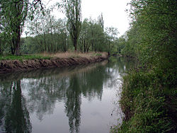
Alpine Rhine near Lustenau
Location
CountryAustria
StateVorarlberg
CountryLiechtenstein
CountrySwitzerland
CantonsGrisons, St. Gallen
Physical characteristics
Source 
 • locationConfluence of Vorderrhein and Hinterrhein in Reichenau
 • coordinates46°49.37094′N 9°24.45204′E / 46.82284900°N 9.40753400°E / 46.82284900; 9.40753400
 • elevation604 m
Mouth 
 • location
Rhine delta, Upper Lake Constance
 • coordinates
46°49.37094′N 9°24.45204′E / 46.82284900°N 9.40753400°E / 46.82284900; 9.40753400 (of canal)
 • elevation
395 m
Length93.5 km (58.1 mi)
Basin size6119 km2
Basin features
Tributaries 
 • leftSaar, Tamina
 • rightIll, Frutz, Liechtenstein inland canal, Landquart, Plessur

The Alpine Rhine (German: Alpenrhein, pronounced [ˈalpn̩ˌʁaɪn] ) is the section of the river Rhine from its source in the Swiss Alps to Lake Constance. It begins in the centre of the Swiss canton of Grisons (Kanton Graubünden), and later forms the border between Switzerland to the west and Liechtenstein to the east, and later between Switzerland and Austria. It flows through the Alpine Rhine Valley.

There is no shipping on the Alpine Rhine.

Description

[edit]
Sections of the Rhine:
  Alpine Rhine, Vorderrhein, Hinterrhein

The Alpine Rhine is formed near Tamins-Reichenau by the confluence of the rivers Anterior Rhine (Vorderrhein) and the Posterior Rhine (Hinterrhein). Its mouth is at the Upper Lake Constance. It descends from an elevation of 585 to 396 metres (1,919 to 1,299 ft). The river makes a distinctive turn to the north near Chur. At Landquart it turns north-east and then to the north around the Fläscherberg, east of Sargans. Near Sargans a natural dam, only a few metres high, prevents it from flowing further to the north-west into the open valley, called Seeztal, and then consequently through Lake Walen (and further to Lake Zurich into the river Aare).

The Alpine Rhine is flanked by the Alps and its mountain ranges (especially Alpstein, Plessuralpen, Rätikon Calanda, the Albula Alps and the Glarner Alps), some higher than 3,000 m (9,800 ft). The highest mountain, Ringelspitz, commences next to Tamins. At 3,247 m (10,653 ft), it is the highest peak of the canton of St. Gallen, bordering the valley to its southeast.

Besides the Vorderrhein and Hinterrhein, the Apline rhine has only a few other larger tributaries. Its main right tributaries are the Plessur (in Chur), the Landquart in Landquart, the Liechtenstein inland canal in Liechtenstein (near the northern end of the country), and the Ill and Frutz in Austria (Vorarlberg). Main left tributaries, all located in Switzerland, are the Tamina (in Bad Ragaz) and the Saar (in Trübbach).

Designations
Official nameRheindelta
Designated16 December 1982
Reference no.275[1]

The mouth of the Rhine into Lake Constance forms an inland delta. The delta is delimited in the west by the Old Rhine and in the east by a modern canalized section. Most of the delta is a nature reserve and bird sanctuary and has been designated as a Ramsar site since 1982.[1] It includes the Austrian towns of Gaißau, Höchst and Fußach. The natural Rhine originally branched into at least two arms and formed small islands by precipitating sediments.

A regulation of the Rhine was called for, with an upper canal near Diepoldsau and a lower canal at Fußach, in order to counteract the constant flooding and strong sedimentation in the western Rhine Delta. To build and maintain the levees, the International Rhine Regulation Railway was constructed. The Dornbirner Ach had to be diverted, too, and it now flows parallel to the canalized Rhine into the lake. Its water has a darker color than the Rhine; the latter's lighter suspended load comes from higher up the mountains. It is expected that the continuous input of sediment into the lake will silt up the lake. This has already happened to the former Lake Tuggenersee.

The cut-off Old Rhine at first formed a swamp landscape. Later an artificial ditch of about 2 kilometres (1.2 mi) was dug. It was made navigable to the Swiss town of Rheineck.

Alpine Rhine Valley

[edit]
The mouth of the Alpine Rhine in Upper Lake Constance, and the Alpine Rhine Valley looking south
Thurbo trainset crossing the Alpine Rhine between Bad Ragaz and Maienfeld

The Alpine Rhine Valley (German: Alpenrheintal) is a glacial alpine valley, formed by the Alpine Rhine (German: Alpenrhein [ˈalpm̩ʁaɪn] ), the part of the Rhine between the confluence of the Anterior Rhine and Posterior Rhine at Reichenau and Lake Constance. It covers three countries, with sections of the river demarcating the borders between Austria and Switzerland and between Liechtenstein and Switzerland. The full length of the Alpine Rhine is 93.5 km.[2]

From Reichenau, the Alpine Rhine flows east, passing Chur and turning north, before it turns north-east at Landquart, and then roughly north, east of Sargans. From here, the Alpine Rhine forms the border between the canton of St. Gallen of Switzerland on the left, west side, and the Principality of Liechtenstein on the east side. About 28 kilometres (17 mi) further down, the Rhine then meets the Austrian federal state Vorarlberg and finally flows into Lake Constance, south of Lindau (Germany), which is no longer part of the Rhine Valley. The Swiss-Austrian border follows the historical bed of the Rhine, but today the river follows an artificial canal within Austria for the final 5 kilometres (3.1 mi),[3] parallel to the also canalised Dornbirner Ach. The border also still follows the old river bed at Diepoldsau.

The Rhine Valley's upper third has the character of an Alpine valley, enclosing a bottom plain of about 1 to 4 kilometres (0.6 to 2.5 mi) across. Downstream of Vaduz, the valley widens considerably, developing into a broad plain, measuring some 10 kilometres (6.2 mi) across at its lower end along the southeastern shores of Upper Lake Constance. The latter is separated from the Lower Lake Constance by a short stretch of the Rhine, called the Seerhein (English: Lake Line). From the point of the Rhine's emergence from Lower Lake Constance, it is known as the High Rhine (Hochrhein).

Right tributaries of the Alpine Rhine are the Plessur in Chur, the Landquart in the town of the same name, the Ill and Frutz on the Upper Land of the Austrian plain near Feldkirch. Several rivers in Liechtenstein drain into a canal, which carries the water to the Alpine Rhine. The Alpine Rhine has no major left tributaries; creeks joining it from the left are the Oldisbach at Chur, Cosenz at Untervaz, Säge at Tardisbrücke, Tamina at Bad Ragaz, Saar at Trübbach, Tobelbach at Buchs, Simml at Gams. Though all left tributaries in the St. Gall Rhine Valley are collected by the Rheintaler Binnenkanal, which flows into Lake of Constance by Alter Rhein, and never meets the Alpine Rhine anymore.

History

[edit]

The valley of the Alpine Rhine was part of the ancient Roman province of Raetia. The Alemannic people settled the lower Rhine Valley in the early Middle Ages. Under the Frankish Empire, the Rheintal between Montstein and Hirschensprung was given to the Rhinegraviate (the county of the Rheingau), and its first recorded mention is in 891; the area between Lake Constance and Montstein was a part of the Thurgau.

Rule of the Rhine Valley was fragmented throughout the Middle Ages, with the Holy Roman Emperor, the Bishop of Constance, the Abbot of St Gall and the counts of Bregenz and Werdenberg all claiming various portions of the valley. It was not until 1348 that the Rheintal was united, under the county of Werdenberg-Heiligenberg. From when the Habsburgs acquired the county of Tyrol in 1363, they gradually began to gain control of the Rhine Valley, gaining the whole valley through a combination of conquest and purchase by 1395.

See also

[edit]

References

[edit]
Revisions and contributorsEdit on WikipediaRead on Wikipedia
from Grokipedia
The Alpine Rhine (German: Alpenrhein) is the uppermost section of the River, formed by the confluence of the and Hinterrhein rivers at Reichenau in the Swiss canton of Graubünden, and extending northward through a former glacier valley to its outlet into near , . The originates at an elevation of 2,340 meters above sea level from Lake Tômasee in the Adula Alps, while the Hinterrhein arises near the and flows through the deep schist canyon known as the Via Mala, often called the "little Grand Canyon." In its lower course, the river delineates the border between to the west and and (specifically ) to the east, before entering via an inland delta. This transboundary stretch, shared by Switzerland, Liechtenstein, and Austria, has historically been a wild, unregulated mountain river prone to catastrophic floods, with significant ecological and morphological changes occurring over centuries due to natural dynamics and human interventions. The Alpine Rhine Valley, through which it flows, features a narrow upper section (about 1.5 km wide with a 60-meter incised channel) widening to a broader floodplain in the lower reaches, supporting diverse habitats but facing challenges from hydropower operations that cause daily water level fluctuations of up to 1 meter, impacting local flora and fauna. Lake Constance itself, into which the river discharges, spans 535 square kilometers as Central Europe's third-largest inland lake, comprising the deeper Obersee (including the Überlinger See) and the shallower Untersee, connected by the 4-kilometer Seerhein channel, with the Rhine's zero kilometer marker at Constance's old bridge; its waters maintain very good quality suitable for drinking. Human management of the Alpine Rhine dates back to 19th-century regulation efforts, but comprehensive cross-border planning began with the 2005 Entwicklungskonzept Alpenrhein, developed by the Internationale Regierungskommission Alpenrhein (IRKA) and the International Rhine Regulation (IRR), addressing flood risks, ecology, and groundwater recharge. The river's discharge capacity is being enhanced through the RHESI project, a joint Swiss-Austrian initiative under a state treaty signed on May 17, 2024, aiming to raise it from 3,100 cubic meters per second to at least 4,300 cubic meters per second to protect around 450,000 residents and mitigate billions in potential flood damages along the international section from the Ill River confluence to Lake Constance. These efforts shift from traditional "grey" infrastructure like dikes to "green" approaches, promoting natural river dynamics, habitat restoration, and recreational use while improving overall ecological health in this vital Alpine waterway.

Geography

Course and Length

The Alpine Rhine constitutes the uppermost segment of the Rhine River, originating at the confluence of its headwater tributaries, the and Hinterrhein, within the and extending to its outlet into ; this course traverses territories in , , and . The river measures approximately 90 km in length from the Reichenau confluence to its entry into the Upper Lake Constance, descending from an elevation of 604 m at the starting point to 395 m at the lake's surface. Its encompasses 6,119 km², predominantly in the Swiss canton of Graubünden but extending into adjacent regions. The course commences precisely at the Reichenau confluence (46°49.37094′N 9°24.45204′E), where the Vorderrhein and Hinterrhein merge, and proceeds northward through the narrow Rhine Valley past the city of Chur within Swiss territory. Beyond Sargans, the river veers northeast, forming the border between Switzerland and Liechtenstein for about 30 km while passing Vaduz, before continuing northward along the Swiss-Austrian border to its deltaic widening near Bregenz, where it enters Lake Constance. This path follows a former glacial valley, characterized by a relatively steep gradient in its upper reaches that moderates downstream.

Hydrology and Tributaries

The Alpine Rhine exhibits a nival , characterized by significant seasonal variations in discharge driven primarily by and glacial contributions from its high-elevation catchment. The average annual discharge at Diepoldsau, near the river's exit into , is approximately 233 m³/s, with peaks occurring in early summer (June-July) when dominates, often reaching up to 800-1000 m³/s during high-flow periods, and lows in winter dropping to around 100-150 m³/s. Glacial melt from upstream sources, including remnants of the Rheinwaldhorn and other Alpine , contributes substantially to summer flows, accounting for 10-20% of the total discharge in peak seasons, though this influence is diminishing due to ongoing glacier retreat. Several major tributaries augment the Alpine Rhine's flow, each drawing from distinct sub-catchments in the Swiss and Austrian and contributing variably to the main stem's volume. The Plessur, joining near , has a length of 33 km and a mean annual discharge of 8 m³/s from a drainage area of roughly 270 km², providing a steady input from the Schanfigg valley that enhances flow stability in the upper reaches. The Landquart, entering near , extends 38 km with a of 618 km² and an average discharge of about 8.2 m³/s, sourcing from glaciated areas in the Rätikon range and adding sediment-laden waters that influence downstream morphology. From the Austrian side, the Ill joins near Diepoldsau after a 72 km course through , draining 1,281 km² with a mean discharge of 66 m³/s, representing the largest single contribution (nearly 30% of the Alpine Rhine's total at that point) and introducing nival pulses from the Silvretta and Rätikon massifs. The Tamina, merging near , spans 30 km over a 155 km² basin and contributes around 5-10 m³/s on average, fed by thermal springs and melt from the Pizol group, though exact flows vary with local precipitation. The river's hydrology is further shaped by pronounced flood risks, particularly from rapid combined with heavy rainfall, which can elevate discharges to over 1,000 m³/s and cause inundation in the valley floor; these events are mitigated through channel regulation and retention basins implemented since the . Despite its volume, the Alpine Rhine remains non-navigable due to a steep average of about 0.2% and numerous , which accelerate flow and limit commercial transport to short stretches near .

Alpine Rhine Valley

Geology and Formation

The Alpine Rhine Valley is a classic example of a glacial U-shaped trough, primarily sculpted by repeated advances of the during the epoch as part of the broader glaciations that affected the northern . This valley morphology resulted from the erosive power of ice sheets, which overdeepened pre-existing tectonic structures, creating steep, parallel sidewalls and a broad, flat floor characteristic of glacial carving. Underlying this glacial imprint is the tectonic framework established during the , where the collision between the African and European plates from the to the Tertiary (approximately 80 to 30 million years ago) uplifted and folded sedimentary rocks, including limestones and marls from the ancient , forming the Helvetic nappes that constitute much of the valley's bedrock. A key tectonic event in the late Miocene involved the opening of a shear fault zone, which initiated the northward drainage of the proto- and further defined the valley's alignment within the emerging system. In its upper reaches, the valley narrows to 1-4 km in width due to intense glacial and fluvial that confined the river channel within steep, incised gorges, while further downstream it broadens progressively to about 10 km near , where sediment deposition from glacial meltwaters and river loads created expansive alluvial plains. This widening reflects the transition from erosional dominance in the to depositional processes in the foreland, with the Glacier's terminal zones depositing thick layers of that leveled the valley floor. Prominent geological evidence includes lateral and terminal —ridged accumulations of glacial debris—that mark the extents of Pleistocene advances, as well as erratic boulders transported far from their Alpine sources, attesting to the glacier's vast reach and transport capacity. These features, such as the moraine complexes around the former Lake , highlight how multiple glacial cycles (including the Mindel, Riss, and Würm stages) repeatedly reshaped the landscape through cycles of , deposition, and isostatic rebound. The primary phase of valley formation occurred during the Pleistocene, with the most recent major glaciation peaking around 20,000 years ago, when the Rhine Glacier extended to the Swiss Plateau and beyond. Following deglaciation, which began approximately 17,500 years ago with the retreat of ice from the Lake Constance basin, the river initiated deep incision into the unconsolidated glacial sediments around 10,000 years ago at the onset of the Holocene, carving a more defined channel and exposing underlying bedrock in places. This post-glacial downcutting continues today at rates of several millimeters per year in active reaches, driven by the river's high sediment load and gradient, though moderated by ongoing tectonic uplift in the Alpine foreland at about 1-2 mm per year. Such dynamics underscore the valley's evolution as an interplay between glacial legacy and active fluvial-tectonic processes.

Settlements and Borders

The Alpine Rhine traverses a densely populated corridor in the Alpine Rhine Valley, hosting several key settlements that serve as regional hubs for administration, commerce, and culture. , located in the Swiss canton of Graubünden near the river's upper reaches, is the largest city along the course, with a of 39,177 residents as of 2024; it functions as a central transportation and economic node for the surrounding mountainous region. Further downstream, Diepoldsau in the Swiss marks a significant border community, with 6,939 inhabitants as of 2024, supporting cross-border trade and local . On the eastern banks, Feldkirch in the Austrian state of stands as a historic trading center with 36,708 residents as of 2025, known for its and role in regional connectivity. , the capital of , lies directly along the river with a of about 5,800 as of 2024, serving as the principality's political and administrative heart. The river delineates international boundaries for much of its length, shaping the of the region. In its lower course, the Alpine Rhine forms the border between to the west and to the east for approximately 25 km, continuing as the Swiss-Austrian boundary for about 35 km until it reaches . These demarcations, established through historical treaties, have no active disputes today, though past territorial adjustments resolved minor enclaves and ambiguities from medieval and early modern periods. Demographically, the Alpine Rhine Valley supports a total of around 300,000 people across its length, concentrated in the lower stretches due to flatter terrain suitable for development. The area reflects Switzerland's multilingual heritage, with German predominant in Austrian and Liechtensteiner sections as well as lower Swiss valleys, while Romansh influences persist in upper Swiss communities like , fostering a culturally diverse populace. This demographic mosaic underscores the valley's role as a cross-border living space, with settlements benefiting from the river's position as a natural yet integrative frontier.

History

Ancient and Medieval Periods

The Alpine Rhine region exhibits evidence of human settlement dating back to the Early Bronze Age, around 2200 BCE, with archaeological sites revealing graves and habitations influenced by both northern and southern Alpine cultural exchanges. from locations such as Savognin-Padnal and Laax-Salums confirms activity between 2300 and 1600 BCE, including pottery and tools indicative of trade across alpine passes. By the late first millennium BCE, specifically around 400 BCE, the area was inhabited by the Raeti, a confederation of tribes with Celtic linguistic and cultural affinities, who occupied the mountainous valleys and facilitated early trans-Alpine interactions. Following the Roman conquest in 15 BCE, led by and Drusus, the Alpine Rhine became integrated into the province of , serving as a strategic buffer against northern threats and a conduit for imperial administration. The region hosted key settlements, including Rhaetorum (modern ), established as a civilian west of the Plessur River in the CE, featuring baths, workshops, and public structures documented in the Antonini. A late-antique fortification east of the river, likely built under Emperor around 364–375 CE, underscored 's defensive role, with remnants including Christian basilicas and artifacts like a marble inscription honoring . The itself functioned as a vital trade artery, transporting goods such as , , and metals from Alpine sources to and , supported by roads linking passes like the Splügen and Septimer. The decline of Roman authority in the CE coincided with repeated incursions across the , beginning in 213 CE under Chrocus and intensifying through the , as the confederation of Germanic tribes raided and , ravaging the valley and contributing to the fragmentation of provincial control. By the early , these invasions had led to the establishment of the Bishopric of , first attested in 451 CE at the of , which emerged as a pivotal authority amid the power vacuum. The medieval period saw the Alpine Rhine divided into fragmented lordships, with the Bishopric of holding temporal sway over valleys like the and Engadine under Merovingian, Carolingian, and Ottonian oversight; a notable event was the 958 Ottonian donation by Emperor Otto I, which bolstered the bishopric's lands and privileges during his Italian campaigns. This decentralization persisted until the late , when the Habsburgs gradually consolidated control over the Rhine valley through acquisitions and inheritances, achieving unification by 1395 via treaties like that of Hollenburg following the death of Albert III.

Modern Developments

In the early modern period, the region experienced Habsburg dominance, particularly in the and areas, until the dissolution of the in 1806. , acquired piecemeal by the Habsburgs and fully consolidated by 1523, was administered as part of alongside Tyrol, serving as a strategic buffer in the western Habsburg lands. emerged as a distinct entity in 1719 when Habsburg Emperor Charles VI elevated the counties of and Schellenberg to the Imperial Principality of , granting it immediate status within the Empire while maintaining close ties to ; full independence followed in 1806 with the Empire's end. In contrast, the Swiss portion in Graubünden (Grisons) resisted direct Habsburg control through its alliance-based , expanding ties with the Swiss Confederation that culminated in formal incorporation in 1803 via Napoleon's , which restructured Swiss governance and integrated the region into the emerging modern confederation. The 19th and early 20th centuries brought industrialization and geopolitical shifts to the Alpine Rhine valley. In , textile production, especially spinning and , drove economic transformation starting with the first mechanized mill in the Walgau in 1820, leveraging local traditions and skilled labor to establish the region as Austria's leading hub by mid-century. Switzerland's neutrality during the preserved Graubünden's stability, while also remained neutral; , however, endured the disruptions of Austria-Hungary's involvement in and Austria's under in , though the valley's alpine terrain limited direct combat. Post-1945 reconstruction fueled rapid across the region, with 's low-tax policies attracting and finance, elevating its per capita wealth to among the world's highest by the 1970s; and similarly advanced through and services in Graubünden and . A pivotal development was the 1923 treaty between and , which aligned their trade policies, adopted the as currency, and fostered shared economic prosperity without full . Twentieth-century political changes emphasized regional stabilization amid broader . Non-membership in the influenced economic strategies: pursued bilateral accords for , joined the in to participate in the while retaining customs ties to , and benefited from Austria's accession, enhancing cross-border trade along the without fully eroding local autonomy. treaties further solidified the area's configuration, notably through the implementation of the 1892 -Austria Regulation Treaty in the early , which straightened the river's meandering course, mitigated floods, and precisely delineated the shared boundary from Diepoldsau to the Austrian-German frontier, promoting long-term infrastructural and territorial security.

Ecology and Conservation

Flora and Fauna

The Alpine encompasses diverse habitats shaped by its riverine dynamics, including riparian forests along the riverbanks, extensive wetlands in the valley floor, and alpine meadows on surrounding slopes. These environments support a rich , with the delta at serving as a key hotspot due to its shallow waters, reed beds, and mosaics that foster high . The valley's position at the intersection of Western and Eastern Alpine influences contributes to overlapping floral and faunal assemblages, creating transitional zones for both lowland and montane . Riparian forests in the Alpine Rhine are dominated by softwood species adapted to periodic flooding, such as grey alder () and various willows (Salix spp.), which form dense stands along gravel bars and meanders. Reed beds () thrive in margins, providing structural complexity for associated life forms. Endemic and characteristic , including the willow gentian (Gentiana asclepiadea), occur in moist meadows and forest edges, favoring the valley's calcareous soils and moderate altitudes. Overall, the region hosts approximately 600 vascular plant species, particularly concentrated in the delta, where dynamics promote heterogeneity. Aquatic and semi-aquatic fauna in the reflect its oligotrophic waters and gravelly substrates, with fish communities featuring native salmonids like the (Salmo trutta) and European grayling (), which spawn in oxygen-rich riffles. The upper , including the Alpine section, supports approximately 36 fish , though populations are influenced by barriers. Birdlife is diverse, with more than 300 recorded in the delta alone, including breeders and migrants; notable riparian residents are the (Alcedo atthis), which perches along streams to hunt small fish, and the (Ardea cinerea), often seen wading in shallows for amphibians and invertebrates. like the Ruggeller Riet, a Ramsar site designated in 1991, harbor over 1,600 animal , underscoring their role as refugia. Mammalian diversity includes semi-aquatic species recovering through natural recolonization, such as the (Lutra lutra), sighted along tributaries like the Hinterrhein since the early 2010s as populations expand from Austrian source areas. Beavers (Castor fiber) have been reintroduced in since 1956 and now occupy waterways in the Alpine Rhine catchment, engineering wetlands that enhance habitat connectivity. Amphibians, adapted to the valley's ponds and streams, feature the (Ichthyosaura alpestris), which breeds in clear, vegetated waters and exhibits distinct terrestrial phases in surrounding forests. However, from river regulation and infrastructure poses ongoing threats to these populations, reducing and nesting sites for mobile species.

Environmental Protection Efforts

The Rhine Delta, encompassing the area where the Alpine Rhine enters , was designated as a Ramsar site of international importance on 16 December 1982, covering 2,065 hectares in the Austrian portion and supporting diverse habitats critical for waterbird conservation. This designation highlights its role in maintaining ecological connectivity across the Austria-Switzerland-Germany border. Additionally, portions of the Alpine Rhine valley, including the Rhine Delta, are integrated into the EU network, with sites such as the Rhine Delta added since 1995 to protect habitats under the Birds and Habitats Directives.) Environmental protection efforts in the Alpine Rhine have been coordinated through international frameworks, notably the International Commission for the Protection of the Rhine (ICPR), established by the 1963 among , , , the , and to monitor and recommend protective measures. Early 20th-century canal systems, constructed primarily between 1900 and 1920, were implemented for flood control and sediment management, stabilizing the river channel while aiming to mitigate in the alpine reaches. Since the 1990s, restoration initiatives have focused on recreating side arms and reconnecting , with projects in the basin enhancing habitat diversity and natural flow dynamics through over 30 floodplain channel restorations. Ongoing challenges include agricultural pollution from pesticides and nutrients, which contaminate surface and in the Upper Rhine Valley, as detected in recent landscape-scale studies showing widespread current-use residues. exacerbates these issues by altering flow regimes, with projections indicating increased winter discharges and reduced summer low flows in the catchment, potentially straining ecosystems and . A notable success stems from the 1986 near , which released over 1,200 tons of toxic substances into the , prompting the 1987 Rhine Action Programme; this led to substantial improvements by 2000, including a 50-70% reduction in key pollutants and the return of populations.

Human Use and Economy

Infrastructure and Regulation

The regulation of the Alpine Rhine commenced in the early 19th century with systematic straightening efforts aimed at reducing meanders, mitigating risks, and reclaiming land for . These initiatives, inspired by advancements and the need for defense, transformed the river's braided and looping course into a more controlled channel. By the mid-19th century, significant portions of the had been rectified, altering its natural dynamics while enhancing safety in the . In the 1890s, transboundary cooperation formalized these efforts through a treaty between and , enabling joint modifications to the river's course for sustained prevention. This agreement addressed ongoing erosion and flooding exacerbated by earlier structures, marking the start of over a century of collaborative . Modern regulation in the Alpine Rhine delta incorporates diversion canals, such as the Alter Rhein and the canalized section near the Fußacher Durchstich, to channel flow into and reduce pressure on adjacent lands. These structures separate much of the river's discharge from the main channel, promoting sediment management and in the inland delta. Recent efforts focus on enhancing through the RHESI (Rhine High Water ) project, a joint Swiss-Austrian initiative under a state signed on May 17, 2024. As of November 2025, the project is in the detailed planning phase, with construction expected to begin soon and completion projected over the next two decades. It aims to increase the river's discharge capacity from 3,100 cubic meters per second to at least 4,300 cubic meters per second along the international section from the Ill to , protecting approximately 450,000 residents and preventing billions in damages. The approach emphasizes ", including restoration and natural dynamics, over traditional dikes. Transportation infrastructure along the Alpine Rhine emphasizes rail and road networks, supporting regional connectivity without reliance on waterborne shipping. The (Chur–Rorschach line), developed in the and expanded in the following decades, facilitates freight and passenger services through the valley, linking key settlements from to the lake. Parallel motorways, including Switzerland's A13 and Austria's A14, provide efficient overland routes, traversing the steep terrain with tunnels and viaducts to maintain accessibility. Notable bridges, such as the Vaduz Old Bridge connecting to and the Buchs-Schaan crossing, enable cross-border movement while accommodating the river's width. Navigation by ship is impractical along the Alpine Rhine due to its steep of approximately 2.4 meters per kilometer and swift currents, which pose hazards for vessels and limit commercial viability. Instead, the focus remains on land-based systems to handle the valley's transport demands. Water management in the Alpine Rhine involves dams on tributaries for generation, particularly in and , where facilities on rivers like the Ill harness alpine runoff to produce . These installations, often run-of-river types, regulate seasonal flows while contributing to national energy supplies without large reservoirs on the . Discharge monitoring occurs at key stations, including Diepoldsau in and Lustenau and Feldkirch in , providing for and resource allocation. This network supports coordinated management across borders, integrating hydrological observations with broader basin efforts.

Tourism and Recreation

The Alpine Rhine attracts visitors with its dramatic landscapes and diverse recreational opportunities, drawing nature enthusiasts and cultural explorers to the region spanning , , , and . Key attractions include the Rhine Gorge, known as Ruinaulta or the "Swiss Grand Canyon," a protected formed by a prehistoric , featuring steep walls and rare and . This site lies within the World Heritage-listed Tectonic Arena Sardona, recognized for its exceptional geological features illustrating alpine formation processes. Visitors also enjoy panoramic views of the from in , a medieval fortress perched above the river that offers sweeping vistas of the surrounding mountains and floodplain. At the river's delta into , hotspots abound, with over 300 species recorded, including whooper swans and rare migrants, making it one of Europe's premier ornithological sites. Recreational activities emphasize the river's natural and historical elements, with extensive hiking options along trails like the Trans Ruinaulta path through the gorge, providing access to viewing platforms and barbecue areas amid floodplain forests. follows the flat, scenic 15 Route, suitable for all levels as it traces the river from alpine sources to the delta, passing vineyards and historic sites. Rafting adventures on the upper sections navigate rapids through the Gorge, offering thrilling experiences for beginners and experts alike, often combined with leisurely drifts to appreciate the unspoiled scenery. Cultural pursuits include exploring Chur's car-free old town, Switzerland's oldest urban center, with its preserved patrician houses, , and alleyways that reflect 5,000 years of . Tourism significantly bolsters the regional economy, particularly in Graubünden where it accounts for about 30% of , supporting jobs in and guiding services. The sector experiences seasonal peaks in summer, driven by favorable for outdoor pursuits, with sustainable initiatives like eco-trails in protected areas promoting low-impact visitation to preserve the fragile alpine . These efforts include car-free access paths and guided nature tours that minimize environmental disturbance while enhancing visitor education on conservation.

References

Add your contribution
Related Hubs
User Avatar
No comments yet.