_-_Yamalo-Nenets_Autonomous_Okrug.svg/250px-Map_of_Russia_(2014–2022)_-_Yamalo-Nenets_Autonomous_Okrug.svg.png "Yamalo-Nenets Autonomous Okrug")
_-_Yamalo-Nenets_Autonomous_Okrug.svg/2000px-Map_of_Russia_(2014–2022)_-_Yamalo-Nenets_Autonomous_Okrug.svg.png)
Community hub
Recent from talks
Contribute something
Nothing was collected or created yet.
Yamalo-Nenets Autonomous Okrug
View on Wikipedia
The Yamalo-Nenets Autonomous Okrug (Russian: Яма́ло-Не́нецкий автоно́мный о́круг, romanized: Yamalo-Nenetsky avtonomny okrug; Nenets: Ямалы-Ненёцие автономной ӈокрук, romanized: Jamaly-Nenjocije awtonomnoj ŋokruk) also known as Yamalia[14] (Russian: Ямалия) is a federal subject of Russia and an autonomous okrug of Tyumen Oblast. Its administrative center is the town of Salekhard, and its largest city is Novy Urengoy. The 2021 Russian Census recorded its population as 510,490.[15]
Key Information


_-_Yamalo-Nenets_Autonomous_Okrug.svg)
The autonomous okrug borders Krasnoyarsk Krai to the east, the Khanty-Mansi Autonomous Okrug to the south, and the Nenets Autonomous Okrug and Komi Republic to the west.
Geography
[edit]The West Siberian petroleum basin is the largest hydrocarbon (petroleum and natural gas) basin in the world covering an area of about 2.2 million km2, and is also the largest oil and gas producing region in Russia.[16]
The Nenets people are an indigenous tribe who have long survived in this region. Their prehistoric life involved subsistence hunting and gathering, including the taking of polar bears; the practice of hunting polar bears (Ursus maritimus) continues up to the present time.[17]
Yamalo-Nenets Autonomous Okrug is traversed by the northeasterly line of equal latitude and longitude, that is, at the point 70°N and 70°E, with equal degrees. The Polar Urals rise in the western part and the highest point of the okrug, as well as of the whole Ural mountain system, is Mount Payer.[18][19]
The area consists of arctic tundra and taiga, with three large peninsulas – the Yamal Peninsula, Taz Peninsula and the Gyda Peninsula (itself containing the Yavay Peninsula and Mamonta Peninsula). There are nearly 300,000 lakes in the okrug, some of the main ones being Pyakuto, Chyortovo, Neito, Yambuto, Yarroto and Nembuto.[20]
The Ob River flows through Yamalo-Nenets Autonomous Okrug to the Kara Sea via the Gulf of Ob, which dominates the geography of the Okrug (together with its two sub-bays, the Taz Estuary and Khalmyer Bay.[21][22][23]
A number of islands are off the okrug's coast – from west to east, the main ones are Torasovey Island, Bolotnyy Island, Litke Island, Sharapovy Koshki Islands, Bely Island, Shokalsky Island, Petsovyye Islands, Proklyatyye Islands, Oleny Island, and Vilkitsky Island.
History
[edit]On December 10, 1930, Yamal (Nenets) National Okrug (Ямальский (Ненецкий) национальный округ) was formed based on Ural Oblast.
Administrative divisions
[edit]| Number of districts (районы) |
7 |
| Number of towns (города) |
8 |
| Number of urban-type settlements (посёлки городского типа) |
5 |
| Number of selsovets (сельсоветы) |
41 |
| As of 2002:[24] | |
| Number of rural localities (сельские населённые пункты) |
102 |
| Number of uninhabited rural localities (сельские населённые пункты без населения) |
19 |

Administrative and municipal divisions

| Division | Structure | OKATO | OKTMO | Urban-type settlement/ district-level town* |
Rural (selsovet) | ||
|---|---|---|---|---|---|---|---|
| Administrative | Municipal | ||||||
| Salekhard (Салехард) | city | urban okrug | 71 171 | 71 951 | |||
| Gubkinsky (Губкинский) | city | urban okrug | 71 172 | 71 952 | |||
| Labytnangi (Лабытнанги) | city | urban okrug | 71 173 | 71 953 |
|
||
| Nadym (Надым) | city | (under Nadymsky) | 71 174 | 71 916 | |||
| Muravlenko (Муравленко) | city | urban okrug | 71 175 | 71 955 | |||
| Novy Urengoy (Новый Уренгой) | city | urban okrug | 71 176 | 71 956 | |||
| Noyabrsk (Ноябрьск) | city | urban okrug | 71 178 | 71 958 | 1 | ||
| Krasnoselkupsky (Красноселькупский) | district | 71 153 | 71 913 | 3 | |||
| Nadymsky (Надымский) | district | okrug | 71 156 | 71 916 |
|
8 | |
| Priuralsky (Приуральский) | district | 71 158 | 71 918 | 6 | |||
| Purovsky (Пуровский) | district | okrug | 71 160 | 71 920 |
|
5 | |
| Tazovsky (Тазовский) | district | okrug | 71 163 | 71 923 |
|
4 | |
| Shuryshkarsky (Шурышкарский) | district | 71 166 | 71 926 | 8 | |||
| Yamalsky (Ямальский) | district | 71 168 | 71 928 | 6 | |||
Demographics
[edit]
| Year | Pop. | ±% |
|---|---|---|
| 1959 | 62,334 | — |
| 1970 | 79,977 | +28.3% |
| 1979 | 157,616 | +97.1% |
| 1989 | 486,164 | +208.4% |
| 2002 | 507,006 | +4.3% |
| 2010 | 522,904 | +3.1% |
| 2021 | 510,490 | −2.4% |
| Source: Census data | ||
Population: 510,490 (2021 census);[15] 522,904 (2010 census);[25] 507,006 (2002 census);[26] 486,164 (1989 Soviet census).[27]
From 1960 to 2016, Yamal Nenets population increased from 60 000 people to more than 530 000 due to the natural resources discovered in the region. Currently, Yamal Nenets is the only Arctic Region in the Russian Federation that is not experiencing population decline. Despite the growing pressure on the regional environment, former governor Dmitry Kobylkin assured in 2016 that industrial developments are not affecting the traditional lifestyles of the native population. Official data accounts for an increment of 11 percent of the indigenous population from 2006 to 2016.[28]

Vital statistics
[edit]| Year | Average population (× 1000) | Live births | Deaths | Natural change | Crude birth rate (per 1000) | Crude death rate (per 1000) | Natural change (per 1000) |
|---|---|---|---|---|---|---|---|
| 1970 | 84 | 1,683 | 879 | 804 | 20.0 | 10.5 | 9.6 |
| 1975 | 127 | 2,307 | 819 | 1,488 | 18.2 | 6.4 | 11.7 |
| 1980 | 194 | 3,347 | 1,178 | 2,169 | 17.3 | 6.1 | 11.2 |
| 1985 | 374 | 7,838 | 1,555 | 6,283 | 21.0 | 4.2 | 16.8 |
| 1990 | 489 | 8,032 | 1,631 | 6,401 | 16.4 | 3.3 | 13.1 |
| 1991 | 483 | 7,121 | 1,623 | 5,498 | 14.7 | 3.4 | 11.4 |
| 1992 | 470 | 6,123 | 2,108 | 4,015 | 13.0 | 4.5 | 8.5 |
| 1993 | 466 | 5,697 | 2,764 | 2,933 | 12.2 | 5.9 | 6.3 |
| 1994 | 473 | 6,274 | 2,998 | 3,276 | 13.3 | 6.3 | 6.9 |
| 1995 | 483 | 6,337 | 3,107 | 3,230 | 13.1 | 6.4 | 6.7 |
| 1996 | 489 | 6,241 | 3,004 | 3,237 | 12.8 | 6.1 | 6.6 |
| 1997 | 495 | 6,208 | 2,715 | 3,493 | 12.5 | 5.5 | 7.1 |
| 1998 | 498 | 6,395 | 2,544 | 3,851 | 12.8 | 5.1 | 7.7 |
| 1999 | 498 | 6,071 | 2,608 | 3,463 | 12.2 | 5.2 | 7.0 |
| 2000 | 497 | 5,839 | 2,763 | 3,076 | 11.7 | 5.6 | 6.2 |
| 2001 | 501 | 6,388 | 3,057 | 3,331 | 12.8 | 6.1 | 6.7 |
| 2002 | 506 | 6,635 | 2,934 | 3,701 | 13.1 | 5.8 | 7.3 |
| 2003 | 510 | 7,163 | 3,093 | 4,070 | 14.1 | 6.1 | 8.0 |
| 2004 | 511 | 7,264 | 2,975 | 4,289 | 14.2 | 5.8 | 8.4 |
| 2005 | 512 | 7,148 | 3,099 | 4,049 | 14.0 | 6.0 | 7.9 |
| 2006 | 513 | 7,036 | 3,000 | 4,036 | 13.7 | 5.8 | 7.9 |
| 2007 | 515 | 7,700 | 2,937 | 4,763 | 14.9 | 5.7 | 9.2 |
| 2008 | 517 | 7,892 | 2,959 | 4,933 | 15.3 | 5.7 | 9.5 |
| 2009 | 519 | 8,216 | 2,924 | 5,292 | 15.8 | 5.6 | 10.2 |
| 2010 | 522 | 8,263 | 2,873 | 5,390 | 15.8 | 5.5 | 10.3 |
| Source:[29] | |||||||
Regional demographics
[edit].jpg)

| Raion | Pp (2007) | Births | Deaths | Growth | BR | DR | NGR |
|---|---|---|---|---|---|---|---|
| Yamalo-Nenets Autonomous Okrug | 538,600 | 5,814 | 2,202 | 3,612 | 14.39 | 5.45 | 0.89% |
| Salekhard | 40,500 | 499 | 256 | 243 | 16.43 | 8.43 | 0.80% |
| Gubkinsky | 22,300 | 263 | 71 | 192 | 15.72 | 4.25 | 1.15% |
| Labytnangi | 27,700 | 333 | 212 | 121 | 16.03 | 10.20 | 0.58% |
| Muravlenko | 37,000 | 361 | 104 | 257 | 13.01 | 3.75 | 0.93% |
| Nadym | 48,500 | 443 | 197 | 246 | 12.18 | 5.42 | 0.68% |
| Novy Urengoy | 117,000 | 1,122 | 334 | 788 | 12.79 | 3.81 | 0.90% |
| Noyabrsk | 109,900 | 1,029 | 384 | 645 | 12.48 | 4.66 | 0.78% |
| Krasnoselkupsky | 6,200 | 99 | 41 | 58 | 21.29 | 8.82 | 1.25% |
| Nadymsky | 21,300 | 221 | 67 | 154 | 13.83 | 4.19 | 0.96% |
| Priuralsky | 15,300 | 179 | 72 | 107 | 15.60 | 6.27 | 0.93% |
| Purovsky | 49,900 | 548 | 195 | 353 | 14.64 | 5.21 | 0.94% |
| Tazovsky | 17,200 | 268 | 92 | 176 | 20.78 | 7.13 | 1.36% |
| Shuryshkarsky | 9,900 | 144 | 69 | 75 | 19.39 | 9.29 | 1.01% |
| Yamalsky | 15,900 | 305 | 108 | 197 | 25.58 | 9.06 | 1.65% |
| Source:[30] | |||||||
Ethnic groups
[edit]The Nenets make up 8.9% of the population, preceded by ethnic Russians (62.9%), and followed by Tatars (4.7%) and Ukrainians (4.5%). Other prominent ethnic groups include Khanty (2.5%), Azerbaijanis (1.7%), Bashkirs (1.5%), Kumyks (1.2%), and Nogais (0.9%) (all figures are from the 2021 Census).[31] Due to the area's oil and natural gas wealth, it is one of the few places in Russia where the ethnic Russian population is growing.[citation needed]
| Ethnic group |
1939 Census | 1959 Census | 1970 Census | 1979 Census | 1989 Census | 2002 Census | 2010 Census1 | 2021 Census | ||||||||
|---|---|---|---|---|---|---|---|---|---|---|---|---|---|---|---|---|
| Number | % | Number | % | Number | % | Number | % | Number | % | Number | % | Number | % | Number | % | |
| Russians | 19,308 | 42.1% | 27,789 | 44.6% | 37,518 | 46.9% | 93,750 | 59.0% | 292,808 | 59.2% | 298,359 | 58.8% | 312,019 | 61.7% | 253,306 | 62.9% |
| Ukrainians | 395 | 0.9% | 1,921 | 3.1% | 3,026 | 3.8% | 15,721 | 9.9% | 85,022 | 17.2% | 66,080 | 13.0% | 48,985 | 9.7% | 18.234 | 4.5% |
| Nenets | 13,454 | 29.3% | 13,977 | 22.4% | 17,538 | 21.9% | 17,404 | 11.0% | 20,917 | 4.2% | 26,435 | 5.2% | 29,772 | 5.9% | 35,917 | 8.9% |
| Tatars | 1,636 | 3.6% | 3,952 | 6.3% | 4,653 | 5.8% | 8,556 | 5.4% | 26,431 | 5.3% | 27,734 | 5.5% | 28,509 | 5.6% | 18,912 | 4.7% |
| Khanty | 5,367 | 11.7% | 5,519 | 8.9% | 6,513 | 8.1% | 6,466 | 4.1% | 7,247 | 1.5% | 8,760 | 1.7% | 9,489 | 1.9% | 9,985 | 2.5% |
| Komi | 4,722 | 10.3% | 4,866 | 7.8% | 5,445 | 6.8% | 5,642 | 3.6% | 6,000 | 1.2% | 6,177 | 1.2% | 5,141 | 1.0% | 3,556 | 0.9% |
| Selkups | 87 | 0.2% | 1,245 | 2.0% | 1,710 | 2.1% | 1,611 | 1.0% | 1,530 | 0.3% | 1,797 | 0.4% | 1,988 | 0.4% | 2,001 | 0.5% |
| Others | 871 | 1.9% | 3,065 | 4.9% | 3,574 | 4.5% | 9,694 | 6.1% | 54,889 | 11.1% | 71,664 | 14.1% | 74,625 | 14.3% | 70,873 | 15.1% |
| 1 17,517 people were registered from administrative databases, and could not declare an ethnicity. The proportion of ethnicities in this group is estimated to be the same as that of the declared group.[32] | ||||||||||||||||
Religion
[edit]According to a 2012 survey[33] 42.2% of the population of Yamalia adhere to the Russian Orthodox Church, 14% are unaffiliated generic Christians, 1% are believers in Orthodox Christianity who do not belong to any church, 1% are members of the Slavic neopaganism (Rodnovery) or practitioners of local shamanic religions, and 1% are members of Protestant churches; Muslims, mostly Caucasian peoples and Tatars, make up 18% of the total population. In addition, 14% of the population declare to be "spiritual but not religious", 8% are atheist, and 0.8% follow other religions or did not give an answer to the question.[33]
Economy
[edit].jpg)
In 2009, Yamalo-Nenetsky Avtonomny Okrug is Russia's most important source of natural gas, with more than 90% of Russia's natural gas being produced there. The region also accounts for 12% of Russia's oil production.[35] The region is the most important to Russia's largest company Gazprom, whose main production fields are located there. Novatek – the country's second-largest gas producer – is also active in the region, with its headquarters located in Tarko-Sale. According to Novatek on 22 October 2019, the natural gas reserves in the Yamalo-Nenets Autonomous Okrug represent 80% of Russia's natural gas and 15% of the world's natural gas supply.[36]
Since the early 2010s Gazprom has been developing Yamal project in the Yamal Peninsula area. As of 2020, Yamal produces over 20% of Russia's gas, which is expected to increase to 40% by 2030. The shortest pipeline routes from Yamal to the northern EU countries are the Yamal–Europe pipeline through Poland and Nord Stream 1 to Germany.[37] The proposed gas route from Western Siberia to China is known as Power of Siberia 2 pipeline.[38]
Notable people
[edit]- Anastasia Lapsui (b. 1944), Nenets film director, screenwriter, radio journalist
See also
[edit]References
[edit]- ^ Президент Российской Федерации. Указ №849 от 13 мая 2000 г. «О полномочном представителе Президента Российской Федерации в федеральном округе». Вступил в силу 13 мая 2000 г. Опубликован: "Собрание законодательства РФ", No. 20, ст. 2112, 15 мая 2000 г. (President of the Russian Federation. Decree #849 of May 13, 2000 On the Plenipotentiary Representative of the President of the Russian Federation in a Federal District. Effective as of May 13, 2000.).
- ^ Госстандарт Российской Федерации. №ОК 024-95 27 декабря 1995 г. «Общероссийский классификатор экономических регионов. 2. Экономические районы», в ред. Изменения №5/2001 ОКЭР. (Gosstandart of the Russian Federation. #OK 024-95 December 27, 1995 Russian Classification of Economic Regions. 2. Economic Regions, as amended by the Amendment #5/2001 OKER. ).
- ^ Law #119-ZAO
- ^ Charter of Yamalo-Nenets Autonomous Okrug, Article 1
- ^ a b Charter of Yamalo-Nenets Autonomous Okrug, Article 11
- ^ Official website of Yamalo-Nenets Autonomous Okrug. Dmitry Nikolayevich Kobylkin, Governor of Yamalo-Nenets Autonomous Okrug Archived August 1, 2018, at the Wayback Machine (in Russian)
- ^ "Сведения о наличии и распределении земель в Российской Федерации на 01.01.2019 (в разрезе субъектов Российской Федерации)". Federal Service for State Registration, Cadastre and Cartography. Archived from the original on February 9, 2022. Retrieved August 29, 2023.
- ^ "Оценка численности постоянного населения по субъектам Российской Федерации". Federal State Statistics Service. Retrieved September 1, 2022.
- ^ "26. Численность постоянного населения Российской Федерации по муниципальным образованиям на 1 января 2018 года". Federal State Statistics Service. Retrieved January 23, 2019.
- ^ "Об исчислении времени". Официальный интернет-портал правовой информации (in Russian). June 3, 2011. Retrieved January 19, 2019.
- ^ Official throughout the Russian Federation according to Article 68.1 of the Constitution of Russia.
- ^ Charter of Yamalo-Nenets Autonomous Okrug, Article 15
- ^ Yamalo-Nenets Autonomous Okrug Territorial Branch of the Federal State Statistics Service. Численность населения Archived March 4, 2016, at the Wayback Machine (in Russian)
- ^ "Fig 1 – uploaded by Thomas M. Melvin". July 2013.
{{cite web}}: CS1 maint: url-status (link) - ^ a b Russian Federal State Statistics Service. Всероссийская перепись населения 2020 года. Том 1 [2020 All-Russian Population Census, vol. 1] (XLS) (in Russian). Federal State Statistics Service.
- ^ Ulmishek, Gregory F. "West Siberian Oil Basin". PetroNeft Resources Plc. Archived from the original on February 24, 2023. Retrieved January 29, 2022.
- ^ C. Michael Hogan (2008) Polar Bear: Ursus maritimus, Globaltwitcher.com, ed. Nicklas Stromberg Archived December 24, 2008, at the Wayback Machine
- ^ "Gora Payer - Peakbagger.com". www.peakbagger.com.
- ^ Google Earth
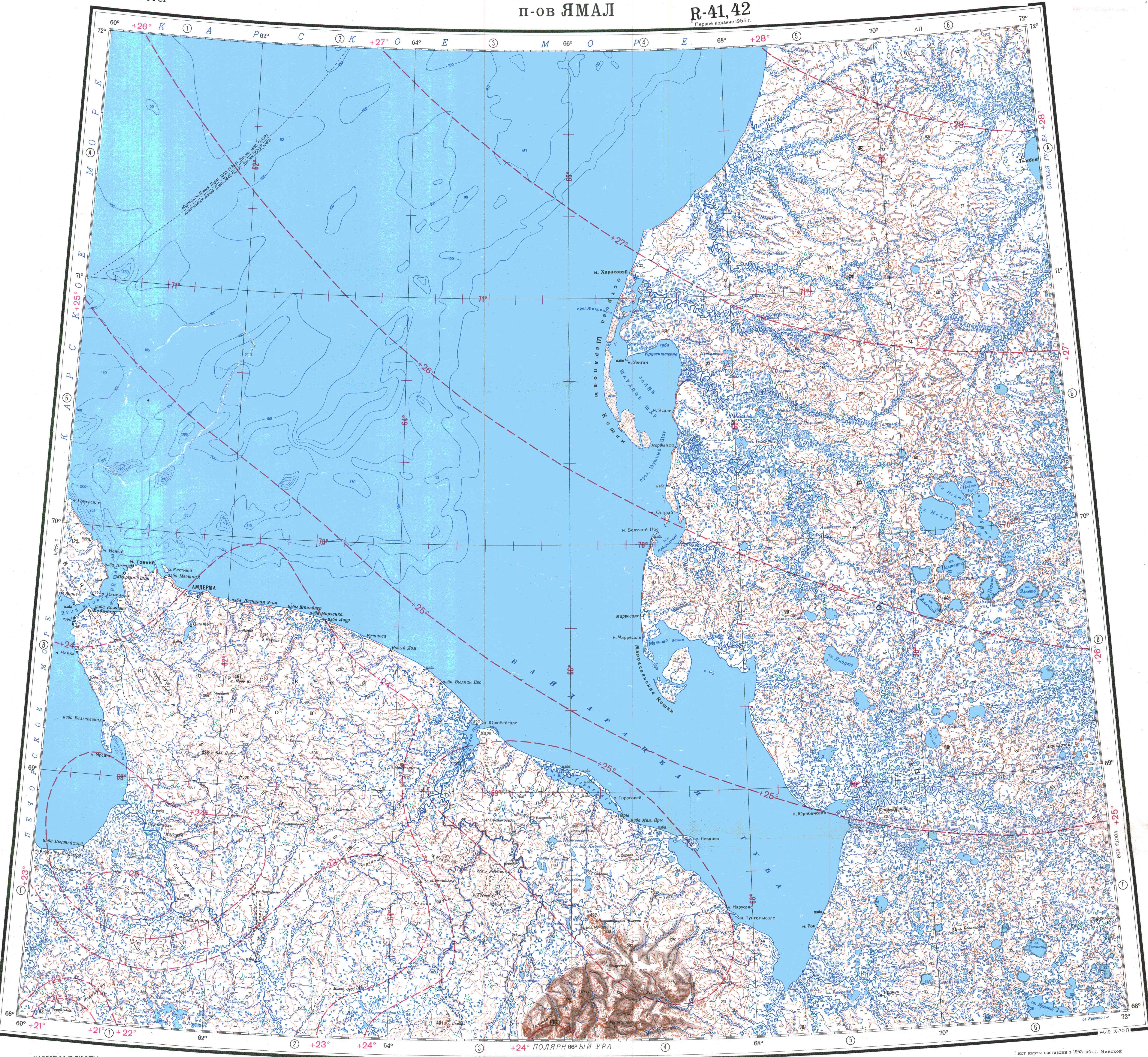
- ^ "R-41_42 Topographic Chart (in Russian)". Retrieved June 8, 2022.
- ^ Regional Index: Regional Index, accessdate: May 5, 2017
- ^ Britannica: ob, accessdate: May 5, 2017
- ^ Yamalo-Nenets region, Russia facts, resources, climate, photos: Yamalo-Nenets region, Russia facts, resources, climate, photos, accessdate: May 5, 2017
- ^ Results of the 2002 Russian Population Census—Territory, number of districts, inhabited localities, and rural administrations of the Russian Federation by federal subject perepis2002.ru Archived September 28, 2011, at the Wayback Machine
- ^ Russian Federal State Statistics Service (2011). Всероссийская перепись населения 2010 года. Том 1 [2010 All-Russian Population Census, vol. 1]. Всероссийская перепись населения 2010 года [2010 All-Russia Population Census] (in Russian). Federal State Statistics Service.
- ^ Federal State Statistics Service (May 21, 2004). Численность населения России, субъектов Российской Федерации в составе федеральных округов, районов, городских поселений, сельских населённых пунктов – районных центров и сельских населённых пунктов с населением 3 тысячи и более человек [Population of Russia, Its Federal Districts, Federal Subjects, Districts, Urban Localities, Rural Localities—Administrative Centers, and Rural Localities with Population of Over 3,000] (XLS). Всероссийская перепись населения 2002 года [All-Russia Population Census of 2002] (in Russian).
- ^ Всесоюзная перепись населения 1989 г. Численность наличного населения союзных и автономных республик, автономных областей и округов, краёв, областей, районов, городских поселений и сёл-райцентров [All Union Population Census of 1989: Present Population of Union and Autonomous Republics, Autonomous Oblasts and Okrugs, Krais, Oblasts, Districts, Urban Settlements, and Villages Serving as District Administrative Centers]. Всесоюзная перепись населения 1989 года [All-Union Population Census of 1989] (in Russian). Институт демографии Национального исследовательского университета: Высшая школа экономики [Institute of Demography at the National Research University: Higher School of Economics]. 1989 – via Demoscope Weekly.
- ^ Staalesen, Atle (October 8, 2016). "The Russian Arctic growth region". The Independent Barents Observer. Retrieved January 6, 2021.
- ^ "Russian Federal State Statistics Service".
- ^ http://www.oblstat.tmn.ru/statinfo\act\dwiz.htm[permanent dead link] for 2008 (January–October)
- ^ "Russian Census of 2021". (in Russian)
- ^ Перепись-2010: русских становится больше. Perepis-2010.ru (2011-12-19). Retrieved on 2013-08-20.
- ^ a b c "Arena: Atlas of Religions and Nationalities in Russia". Sreda, 2012.
- ^ 2012 Arena Atlas Religion Maps. "Ogonek", № 34 (5243), 27/08/2012. Retrieved 21/04/2017. Archived.
- ^ "Yamalo-Nenets Autonomous Area". Kommersant. March 5, 2004. Archived from the original on September 7, 2009. Retrieved August 26, 2009.
- ^ "Пресс-релизы и мероприятия: Сообщение ПАО "НОВАТЭК" в отношении танкеров ледового класса Arc7" [Press releases and events: Communication from PAO NOVATEK regarding Arc7 ice class tankers]. Novatek website. Moscow. October 22, 2019. Archived from the original on October 22, 2019. Retrieved January 4, 2020.
- ^ Yermakov, Vitaly (September 2021). Big Bounce: Russian gas amid market tightness (PDF) (Report). Oxford Institute for Energy Studies.
- ^ "'Power of Siberia 2' Pipeline Could See Europe, China Compete for Russian Gas". VOA News. January 18, 2022.
Sources
[edit]- Законодательное Собрание Ямало-Ненецкого автономного округа. Закон №119-ЗАО от 17 ноября 2010 г. «О гимне Ямало-Ненецкого автономного округа». Вступил в силу со дня официального опубликования (20 ноября 2010 г.). Опубликован: "Красный Север", спецвыпуск №147/1, 20 ноября 2010 г. (Legislative Assembly of Yamalo-Nenets Autonomous Okrug. Law #119-ZAO of November 17, 2010 On the Anthem of Yamalo-Nenets Autonomous Okrug. Effective as of the day of the official publication (November 20, 2010).).
- Государственная Дума Ямало-Ненецкого автономного округа. №56-ЗАО 28 декабря 1998 г. «Устав (Основной Закон) Ямало-Ненецкого автономного округа», в ред. Закона №140-ЗАО от 21 декабря 2015 г. «О внесении изменений в Устав (Основной Закон) Ямало-Ненецкого автономного округа». Вступил в силу 15 января 1999 г. Опубликован: "Красный Север", 15 января 1999 г. (State Duma of Yamalo-Nenets Autonomous Okrug. #56-ZAO December 28, 1998 Charter (Basic Law) of Yamalo-Nenets Autonomous Okrug, as amended by the Law #140-ZAO of December 21, 2015 An Amending the Charter (Basic Law) of Yamalo-Nenets Autonomous Okrug. Effective as of January 15, 1999.).
External links
[edit]- (In Russian) Informational website of Yamalo-Nenets Autonomous Okrug Archived May 14, 2021, at the Wayback Machine
| Districts | |||
|---|---|---|---|
| Cities and towns | |||
| Urban-type settlements | |||
| National | |
|---|---|
| Geographic | |
Yamalo-Nenets Autonomous Okrug
View on GrokipediaGeography
Terrain and Natural Features
The Yamalo-Nenets Autonomous Okrug lies in the northern portion of the West Siberian Plain within Russia's Arctic zone, encompassing predominantly flat tundra terrain.[3] Approximately half of its area extends north of the Arctic Circle, featuring vast expanses of arctic tundra interspersed with taiga elements in the southern reaches.[4] The landscape includes the Yamal Peninsula, which projects into the Kara Sea, and the tundra zones of the Gydan Peninsula on either side of the Ob River estuary.[5] A dense network of waterways defines much of the region's hydrology, with the Ob River traversing the territory and discharging into the Kara Sea through the Gulf of Ob, alongside major tributaries such as the Pur, Taz, Nadym, Yuribey, and Messo-Yakha.[4] The okrug contains around 50,000 rivers and 300,000 lakes, contributing to its marshy and wetland-dominated features.[4] The northern coastline along the Kara Sea features Arctic coastal landforms, including bays and low-lying shores subject to seasonal ice cover. The entire territory falls within the permafrost zone, where continuous and discontinuous permafrost underlies the thin active soil layer, shaping landforms such as thermokarst lakes and polygonal tundra patterns.[6] Elevations remain low across most of the plain, fostering a monotonous relief broken only by occasional ridges and the distant influence of the Polar Ural foothills in the west.[3] These natural features support nomadic reindeer herding while posing challenges for infrastructure due to the unstable ground and extreme conditions.Climate and Environmental Conditions
The Yamalo-Nenets Autonomous Okrug experiences a subarctic to arctic climate, classified primarily under Köppen Dfc (humid continental with cool summers and no dry season), characterized by prolonged, severe winters and brief, cool summers. Average annual temperatures range from -10°C to -5°C, with January lows reaching -40°C or lower and absolute minima recorded at -57°C. Summers in July average 15°C, with maxima up to 29°C. Precipitation is low, typically under 300-400 mm annually, concentrated in summer months and rarely exceeding 50 mm per month, contributing to the region's tundra dryness.[7][8][9] The territory spans three climatic subzones: arctic in the north, subarctic in the central areas, and northern taiga in the south, influencing vegetation from moss-lichen tundra to sparse forests. Winters last 8-9 months with polar nights of 30-60 days and minimal snowfall due to low moisture, while summers feature polar days of 50-80 days but persistent cool temperatures limit thaw. Long-term trends show warming, with air temperatures rising 1-2°C over the past 30 years and spring temperatures increasing by approximately 0.2°C per decade from 1900 to 2008.[4][10][11][12] Environmental conditions are dominated by continuous permafrost covering the entire region, with ice-rich substrates widespread in the low Arctic tundra, leading to thermokarst features like shifting hills and potential craters from gas emissions. Tundra ecosystems support lichens, mosses, and dwarf shrubs adapted to frozen soils, but permafrost thaw from warming exacerbates soil instability and alters hydrology. Indigenous Nenets possess detailed knowledge of snow, ice, and permafrost dynamics, integral to their reindeer herding.[10][13][14] Oil and gas extraction, a major economic driver, impacts these fragile environments through vegetation disturbance, permafrost degradation, and pollution risks including air emissions, biodiversity loss, and historic petroleum spills in tundra areas. Small-scale disturbances from infrastructure can persist due to slow recovery in permafrost soils, while projects like Yamal LNG have raised concerns over habitat fragmentation for wildlife and reindeer migration routes. Mitigation efforts include establishing a carbon control area in 2021 to monitor emissions.[11][15][16][17]History
Indigenous Origins and Pre-Russian Era
The indigenous population of the Yamalo-Nenets Autonomous Okrug primarily consists of the Nenets people, a Samoyedic ethnic group belonging to the Uralic language family, whose name derives from a term meaning "man" or "person." Genetic studies indicate that Nenets ancestry includes approximately 57% from Ancient North Eurasians, associated with the 24,000-year-old Mal'ta boy remains, 38% shared with the 45,000-year-old Ust’-Ishim individual, and admixtures with Eastern Siberian populations dated to 6,800–9,900 years ago, with divergence from related Uralic groups like Mansi and Khanty around 4,800 years ago.[18] Archaeological evidence on the Yamal Peninsula reveals human settlements dating back to at least the 5th century BCE, with sites such as burial grounds and fortifications indicating continuous occupation by proto-Samoyedic or ancestral groups through the medieval period.[19] Prior to Russian colonization in the late 16th century, the Nenets maintained a nomadic lifestyle centered on reindeer herding, supplemented by hunting wild reindeer, fishing, and gathering, adapted to the Arctic tundra environment of the Yamal Peninsula and surrounding areas. Tundra Nenets, predominant in the region, managed herds of 70–100 reindeer per household, utilizing the animals for meat, blood, fat, milk, transport, clothing, tents, and tools, which formed the basis of their subsistence economy and social structure organized into patrilineal clans with exogamous marriage practices. Shamanism dominated their spiritual beliefs, with shamans serving as intermediaries between the human world and spirits, guiding rituals tied to reindeer cycles and environmental survival.[20] Early historical records from the 11th century document awareness of Yamal's indigenous inhabitants, referred to as Nenets (then often called Samoyeds) and neighboring Khanty, engaging in seasonal migrations across vast territories from the Arctic coast to forest edges, covering distances up to 500 kilometers biannually to access pastures and resources. These pre-colonial societies remained small-scale and dispersed, with no evidence of large urban centers, reflecting a resilient adaptation to the harsh subarctic conditions that preserved their cultural continuity for millennia before external influences.[21][20]Russian Colonization and Imperial Period
Russian expansion into the Yamalo-Nenets region began as part of the broader conquest of Siberia following the defeat of the Khanate of Sibir in 1581, with early contacts near the Ob River mouth recorded as early as 1364–1365 according to Novgorod chronicles.[22] By 1483, Moscow dispatched an expedition across the Urals specifically to subdue the Nenets (then called Nentsy), establishing initial tributary relations.[22] The founding of Obdorsk fort in 1595—now Salekhard, the region's administrative center—marked the first permanent Russian outpost in the area, serving as a base for further penetration into the tundra and imposing control over indigenous nomadic groups.[22] Shortly thereafter, in 1600–1601, Cossacks from Tobolsk established Mangazeia on the Taz River, a key trans-Ural trade colony that facilitated access to northern fur resources via overland and sea routes.[22] Economic activities centered on the fur trade, with Russians demanding yasak—tribute in pelts such as sable, squirrel, and polar fox—from Nenets herders, who exchanged them for flour, iron tools, and alcohol.[22] Mangazeia emerged as a prosperous hub, collecting 4,500 sable furs by 1629 alone, though its overland sea route was restricted by 1619 to curb foreign competition from Dutch and English traders.[22] Nenets resistance to tribute collection often met with violent reprisals, including executions, prompting tactics like distributing wine in 1631 to encourage compliance; these dynamics strained indigenous reindeer-based economies, as herders diverted time from migration to hunting for pelts.[22] Permanent Russian settlement remained sparse due to the severe Arctic climate and permafrost, limiting colonization to administrative forts, voevodes (governors), and transient Cossack enforcers rather than agricultural or mass migration.[23] During the 18th century, the Great Northern Expedition (1734–1737) under figures like Ovtsyn mapped coastal areas, enhancing imperial knowledge but yielding little beyond confirmatory surveys of the barren tundra.[22] Tensions culminated in the early 19th century with the Mandalada uprising (1825–1839), led by Nenets chief Vauli Piettomin, who redistributed reindeer herds and rejected tribute demands, reflecting ongoing indigenous pushback against extractive policies until suppression restored Russian oversight.[22] Overall, imperial control prioritized resource extraction over integration, preserving Nenets autonomy in daily nomadic life while enforcing fiscal obligations through fortified outposts.[22]Soviet Formation and Industrialization
The Yamalo-Nenets Autonomous Okrug originated as the Yamal (Nenets) National Okrug, established on December 10, 1930, within Ural Oblast as part of the Soviet nationalities policy to delineate territories for indigenous groups like the Nenets, whose traditional nomadic reindeer herding dominated the sparsely populated tundra. In 1934, the okrug was reassigned to Omsk Oblast following administrative reorganizations, and by April 1944, it was incorporated into Tyumen Oblast, reflecting broader Soviet efforts to centralize control over remote northern regions amid wartime and post-war restructuring. Early Soviet governance emphasized collectivization of indigenous economies, including forced integration of Nenets herders into state farms (kolkhozy) by the 1930s, which disrupted traditional migration patterns but yielded limited industrial output due to logistical challenges in the permafrost zone.[3][6] Industrialization accelerated in the 1960s under the Soviet Union's ninth and tenth five-year plans, which prioritized hydrocarbon exploration in West Siberia to offset declining older fields and fund heavy industry, with Tyumen Oblast (encompassing Yamalo-Nenets) designated a key prospecting area. Geological surveys by state entities like the Ministry of Geology identified vast natural gas reserves, culminating in the discovery of the Urengoy field—one of the world's largest, with initial recoverable reserves exceeding 10 trillion cubic meters—in June 1966 through seismic and drilling operations. This breakthrough prompted infrastructure mobilization, including the founding of Novy Urengoy in 1975 as a purpose-built worker settlement to support field development, rapidly growing from a construction outpost to a city with over 100,000 residents by the early 1980s via influxes of specialized labor from across the USSR.[24][25][26] Commercial gas production at Urengoy began in 1978, facilitated by the construction of the Urengoy-Pomary-Uzhhorod pipeline (initiated 1975 and completed 1983), which enabled exports to Western Europe and generated foreign currency earnings critical to Soviet balances of payments. Additional major fields, such as Yamburg (discovered 1968 with reserves over 8 trillion cubic meters) and those on the Yamal Peninsula like Bovanenkovskoye (prospected in the 1970s), expanded extraction capacity, with annual output from the okrug surpassing 200 billion cubic meters by the late 1980s. This resource-driven boom shifted the economy from subsistence herding—comprising under 5% of activity by 1980—to energy dominance, employing over 70% of the workforce in gas-related sectors and increasing the population from approximately 20,000 in 1960 to more than 500,000 by 1990, primarily through Russian and other Slavic migrants incentivized by state wages and housing. Environmental costs included permafrost thaw from infrastructure and pollution affecting reindeer pastures, though Soviet planning emphasized output quotas over mitigation.[27][25][24]Post-Soviet Resource Expansion
Following the dissolution of the Soviet Union in 1991, natural gas production in Russia, including in the Yamalo-Nenets Autonomous Okrug (YNAO), stagnated during the 1990s amid economic crisis and underinvestment, with overall output leveling off after decades of rapid growth.[28] Recovery began in the early 2000s, fueled by rising global energy prices and renewed state-backed investments, particularly by Gazprom, which prioritized developing untapped reserves in the Yamal Peninsula to offset declining output from older West Siberian fields.[28] By the 2010s, YNAO had solidified its role as Russia's primary gas hub, accounting for approximately 90% of national production and holding over 65% of the country's proven reserves, equivalent to about 20% of global totals.[29][4] Key post-Soviet expansions included Gazprom's commissioning of the Zapolyarnoye field in 2001, one of the world's largest, with initial annual output reaching 100 billion cubic meters by the mid-2000s, and subsequent developments like the Bovanenkovo field, brought online in 2012 with estimated reserves of 4.9 trillion cubic meters and production hitting 99 billion cubic meters by 2020.[28][30] The Yamal megaproject encompassed infrastructure such as the Bovanenkovo-Ukhta pipeline system, enabling transport of northern gas southward, while private initiatives like Novatek's Yamal LNG project, launched with construction in 2013 and first exports in 2017 from the Yuzhno-Tambeyskoye field, diversified extraction methods by producing liquefied natural gas for seaborne trade, reaching full capacity with a second train operational by 2018.[31] These efforts extended to oil and condensate, where YNAO contributes around 20% of Russia's totals, supporting new drilling centers and seismic surveys.[4][32] The resource boom drove profound economic transformation, with hydrocarbon extraction comprising over 88% of YNAO's industrial output and resource volumes tripling between 2005 and 2015, attracting massive investments—including billions from Gazprom for regional cooperation and infrastructure—and fostering supporting industries like pipelines, ports at Sabetta, and icebreaker fleets for Arctic shipping.[33][34][35] This expansion positioned YNAO as a cornerstone of Russia's energy exports, enhancing fiscal revenues through taxes and royalties while integrating the okrug into global markets via LNG terminals and pipelines.[36]Administration and Politics
Administrative Divisions and Governance
The Yamalo-Nenets Autonomous Okrug comprises seven raions (districts) and six urban okrugs as its primary administrative divisions.[3] These raions include the Krasnoselkupsky, Nadymsky, Priuralsky, Purovsky, Shuryshkarsky, Tazovsky, and Yamalsky districts, each managing local rural and mixed territories focused on resource extraction, indigenous affairs, and basic infrastructure. The urban okrugs, which operate as independent municipalities, encompass major population centers such as Novy Urengoy (the largest city by population), Noyabrsk, Gubkinsky, Muravlenko, and the administrative center Salekhard, handling urban development, services, and economic hubs tied to the gas industry.[3] Labytnangi and Nadym also function as significant urban entities within or adjacent to district boundaries. This structure reflects the okrug's federal subject status within Tyumen Oblast, balancing autonomy with oversight from regional and federal levels on matters like land use and taxation.[3] Governance is led by the Governor, the highest executive official, who forms and heads the okrug's government, overseeing policy implementation in energy, environment, and social services. Dmitry Artyukhov has held the position since September 2018, re-elected by the Legislative Assembly in September 2023 for a five-year term expiring in 2028 following presidential nomination.[37][3] The Governor coordinates with federal authorities on strategic projects, such as Arctic infrastructure, while maintaining local control over budgeting and indigenous rights enforcement. The unicameral Legislative Assembly serves as the representative and legislative body, with 22 deputies elected every five years—11 from single-mandate constituencies and 11 via proportional representation from party lists.[3] It approves the budget, enacts regional laws aligned with federal standards, and confirms gubernatorial appointments. The Assembly's current term, post-2025 elections, emphasizes resource revenue allocation and northern development priorities, with United Russia holding a dominant position in prior compositions.[3] This framework ensures fiscal dependence on hydrocarbon exports, with governance emphasizing efficiency in remote conditions over expansive decentralization.[3]Political Dynamics and Leadership
The executive branch of the Yamalo-Nenets Autonomous Okrug is headed by the governor, who is nominated by the President of Russia and confirmed by the regional Legislative Assembly for a five-year term. Dmitry Artyukhov has served as governor since May 29, 2018, when he was appointed acting governor by President Vladimir Putin following the resignation of Yuri Neyelov; Artyukhov was subsequently elected in September 2018 and re-elected in September 2023 with 82.5% of the vote. Born on February 17, 1988, in Novy Urengoy, Artyukhov graduated from Tyumen State University in 2009 with a degree in economics and later obtained an MBA from Singapore Management University in 2013; his career prior to governorship included roles at Gazprom entities and as deputy governor focusing on investment and infrastructure.[38][39][40] The unicameral Legislative Assembly consists of 22 deputies elected every five years, with the most recent election occurring on September 12–14, 2025. United Russia, the ruling party aligned with the federal government, maintains a supermajority in the assembly, enabling seamless passage of legislation supporting resource extraction and Arctic development priorities. Assembly Chairman Sergey Yamkin, a United Russia member, has held the position since September 30, 2015, overseeing policies that prioritize economic growth in natural gas and oil sectors over competing environmental or indigenous land-use claims.[1] Political dynamics in the okrug reflect its economic dependence on federal subsidies and energy revenues, fostering tight alignment with Moscow's directives on industrial expansion and national security, including support for military mobilization efforts. Opposition parties such as the Communist Party and Liberal Democratic Party hold minimal seats and influence, with regional elections typically featuring low turnout and administrative advantages for incumbents, as observed in national patterns of managed competition. Indigenous Nenets representation remains tokenistic, with reindeer herders' associations advocating for land rights amid gas field encroachments, but federal and regional priorities consistently favor Gazprom-led projects, contributing to tensions documented in ethnographic studies of northern resource conflicts.[41][42]Demographics
Population Trends and Vital Statistics
The population of the Yamalo-Nenets Autonomous Okrug was recorded at 510,490 in the 2021 Russian census, reflecting a modest increase from 507,006 in 2002 and 486,164 in 1989, though it dipped slightly from 522,904 in 2010 amid economic cycles in resource extraction. By January 1, 2024, the estimated resident population reached 515,960, with urban residents comprising 439,508 and rural 76,452, indicating overall stability driven less by natural growth alone than by sustained net positive migration. This influx, primarily of working-age individuals from other Russian regions seeking employment in gas and oil fields, has offset national depopulation trends, resulting in a population density of approximately 0.75 persons per square kilometer across the vast 750,000-square-kilometer territory.[4][43] Vital statistics underscore a youthful demographic structure atypical for Russia, with a low share of elderly residents—about one-tenth the national average in comparable northern okrugs—due to the transient, male-dominated migrant workforce in extractive industries. The crude birth rate stood at 9.1 per 1,000 population in recent assessments, supported by regional family incentives amid a predominantly young adult cohort, while the crude death rate was notably low at 5.5 per 1,000 for January–November 2023, below the national figure of around 12 per 1,000. This yielded a positive natural increase, reaching 11.3 per 1,000 as recently as 2019, contrasting with Russia's overall natural decline.[44][1][45][46] Migration dynamics amplify these trends, with net in-migration sustaining growth despite the harsh Arctic climate and rotational work patterns that limit permanent settlement; studies attribute demographic vitality to economic pull factors in energy hubs like Novy Urengoy, where temporary residents outnumber locals. Life expectancy in the okrug exceeds national averages, reflecting better access to healthcare for high-income workers, though precise 2023 figures align with broader Siberian Federal District improvements to around 71 years, bolstered by low mortality from external causes relative to aging-related deaths elsewhere in Russia.[47][48]Ethnic Composition and Languages
The population of Yamalo-Nenets Autonomous Okrug, recorded at 510,490 in the 2021 census, is predominantly ethnic Russian, comprising 62.89% of residents, reflecting extensive in-migration for resource extraction industries.[3] The titular Nenets form the largest indigenous group at 8.92%, totaling approximately 45,500 individuals, primarily concentrated in rural tundra areas where they maintain traditional reindeer herding.[3] Other notable minorities include Tatars (4.70%), Ukrainians (around 4%), Azerbaijanis (1.7%), and Bashkirs (1.5%), with over 126 ethnic groups represented overall due to labor mobility in the energy sector. Smaller indigenous populations encompass Khanty (about 1.9% or 9,489 as of 2010, with similar proportions persisting) and Selkups (around 0.4% or 1,988), classified as small-numbered peoples of the North under Russian law.| Ethnic Group | Percentage (2021 Census) | Approximate Number |
|---|---|---|
| Russians | 62.89% | 320,900 |
| Nenets | 8.92% | 45,500 |
| Tatars | 4.70% | 24,000 |
| Ukrainians | ~4% | ~20,400 |
| Others | ~19.5% | ~99,700 |