Community hub
Abyei
View on Wikipedia
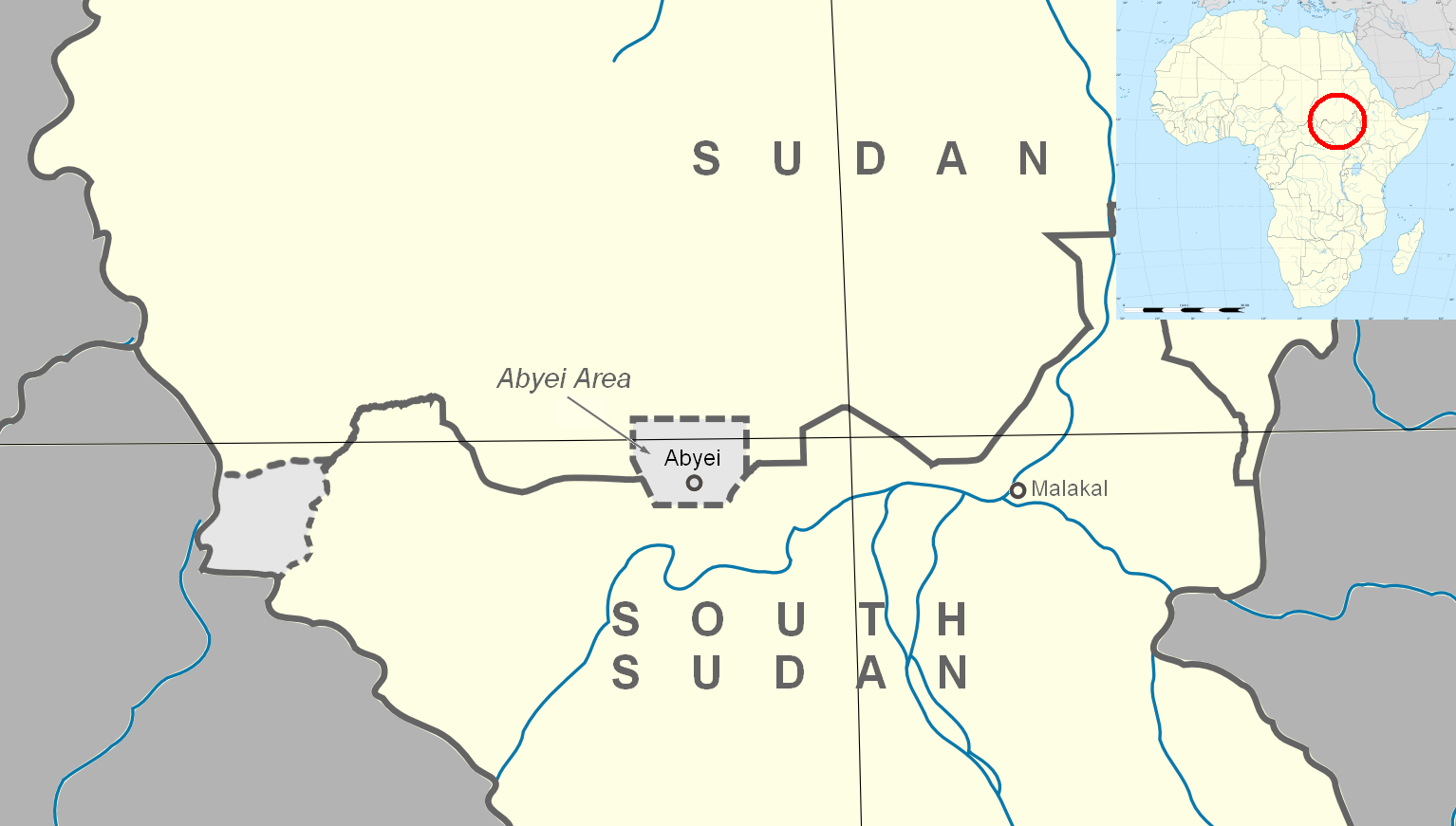
The Abyei Special Administrative Area (Arabic: منطقة أبيي) is an area of 10,546 km2 or 4,072 sq mi[1] on the border between South Sudan and Sudan that has been accorded "special administrative status" by the 2004 Protocol on the Resolution of the Abyei Conflict (Abyei Protocol) in the Comprehensive Peace Agreement (CPA) that ended the Second Sudanese Civil War.[2] The capital of the Abyei Area is Abyei Town. Under the terms of the Abyei Protocol, the Abyei Area is considered, on an interim basis, to be simultaneously part of both the Republic of South Sudan and Republic of Sudan, effectively a condominium.
Key Information


As part of the 2011 independence process, a separate referendum was to be held in Abyei on whether they wanted to join Sudan or South Sudan;[3] however an official referendum was never held.[4][5]
In contrast to the borders of the former district, the Abyei Protocol defined the Abyei Area as "the area of the nine Ngok Dinka chiefdoms transferred to Kordofan in 1905".[2] In 2005, a multinational border commission established this to be those portions of Kordofan south of 10°22′30″ N.[6] However, following continued disputes that erupted into violence and threatened the CPA, an international arbitration process redrew Abyei's boundaries in 2009 to make it significantly smaller, extending no further north than 10°10′00" N.[7] This revised border has now been endorsed by all parties to the dispute.[citation needed]
History
[edit] |
|---|
|
|
 |
|---|
| Constitution |
The Sudan Tribune claims that the Dajo people were located in the region of Abyei prior to the seventeenth century, before being displaced by new migrants.[8] From at least the eighteenth century Abyei was inhabited by the agro-pastoralist Ngok Dinka, a sub-group of the Dinka of Southern Sudan. The Messiria, a nomadic Arab people, who spend most of the year around their base at Muglad in northern South Kurdufan, would graze their cattle south to the Bahr river basin in Abyei during the dry season.[9][10][11] Abyei's permanent residents were thus the southern Dinka, but half the year the Dinka were outnumbered by the Muslim, northern Misseriya.[12] At the establishment of the Anglo-Egyptian Condominium, the Messiria were predominantly located in the province of Kordofan (considered "northern"), while the Ngok Dinka were located in Bahr el Ghazal (considered "southern"). In 1905, after continued raids by the Messiria into Ngok Dinka territory, the British redistricted the nine Ngok Dinka chiefdoms into Kordofan. The reason was threefold: to protect the Ngok Dinka from raids by the Messiria and thus pacify the area; to demonstrate that a new sovereign power was in control; and to bring the two feuding tribes under common administration.[13] When the British left in 1956, they left the status of Abyei unclear.[12]
The two peoples began to take separate paths with the onset of the First Sudanese Civil War (1956–1972), in particular the 1965 massacre of 72 Ngok Dinka in the Misseriya town of Babanusa. The Ngok Dinka were thus drawn to the Anyanya, while the Messiria were favored by the Khartoum-based government and became firmly associated with the north. The 1972 Addis Ababa Agreement that ended the war included a clause that provided for a referendum allowing Abyei to choose to remain in the north or join the autonomous South. This referendum was never held and continued attacks against Ngok Dinka led to the creation of Ngok Dinka unit in the small Anyanya II rebellion, which began in Upper Nile in 1975. The discovery of oil in the area, among other north–south border regions, led President Gaafar Nimeiry to try the first of many initiatives to redistrict oil rich areas into northern administration.[10]
The Ngok Dinka unit of Anyanya II formed one of the foundations of the rebel movement at the beginning of the Second Civil War in 1983. Many Ngok Dinka joined the rebels upon the outbreak of hostilities. Partially as a result of their early entry into the war, many Ngok Dinka rose to leadership positions in the Sudan People’s Liberation Army (SPLA), becoming closely associated with John Garang. In contrast, the Messiria joined the hostilities on the side of the government in the mid-1980s. They formed frontline units as well as Murahleen, mounted raiders that attacked southern villages to loot valuables and slaves.[14] By the end of the war the intense fighting had displaced most Ngok Dinka out of Abyei, which the Misseriya state as justification for ownership of the area.[9]
Status dispute
[edit]Abyei Protocol in the Comprehensive Peace Agreement
[edit]The status of Abyei was one of the most contentious issues in the negotiation of the Comprehensive Peace Agreement. The first protocol signed, the 2002 Machakos Protocol, defined Southern Sudan as the area as of independence in 1956. It thus excluded the SPLA strongholds in Abyei, the Nuba Mountains and Blue Nile, known collectively during the talks as the Three Areas. The SPLA negotiators then spent several years attempting to give these regions the right to a referendum in which they could decide if they want to be under the administrative control of the north or south. This would potentially mean that these regions would become part of a nation of South Sudan after the 2011 independence referendum. The government blocked these attempts, stating that the Machakos Protocol had already delineated the border for the Three Areas in favor of the north.[15]
The deadlock was finally broken by pressure from the United States. U.S. presidential envoy John Danforth circulated a draft agreement, which the U.S. convinced the government to sign despite its inclusion of a referendum. The Protocol on the resolution of the Abyei conflict put Abyei into a special administrative status government directly by the presidency. The precise borders of the area were to be determined by an Abyei Borders Commission (ABC), followed by a referendum commission to identify Messiria that are resident in Abyei and could thus vote in local elections in 2009; all the Ngok Dinka were to be considered resident, it being their traditional homeland.
Abyei Borders Commission
[edit]According to an annex to the protocol adopted in December 2004, the Abyei Borders Commission was to be composed of 15 persons: five appointed by the government, five by the SPLA and three by the Intergovernmental Authority on Development, and one each by the United States and the United Kingdom. Only the five impartial experts could present the final report. The five appointed were: Godfrey Muriuki of the University of Nairobi; Kassahun Berhanu of the Addis Ababa University; Douglas H. Johnson, an author of several works on southern Sudan; Shadrack Gutto, a lawyer from South Africa; and Donald Petterson, a former ambassador to Sudan.[9] The ABC determined the boundary at approximately 10°22′30″N., 87 km (54 mi) north of the town of Abyei, following the agreed rules of procedure.[16] The process and the map showing the boundary is detailed by Johnson.[6]
The ABC presented their report to the president on 14 July 2005, whereupon it was immediately rejected by the government, who accused the experts of using sources after 1905 in their determination of the boundaries. The death of John Garang later that month pushed all other issues off the national agenda, but the SPLA maintains that the terms of the Abyei protocol must be held to.[17] Government resistance to an agreement is largely based on an attempt to hold on to the oil reserves and oil pipelines in the area.[18]
Renewed tensions and violence
[edit]In October 2007, rising tensions between the SPLA and government resulted in the SPLA temporarily withdrawing from the Government of National Unity over several deadlocked issues, notably Abyei.[19] At the time, the International Crisis Group stated, "What happens in Abyei is likely to determine whether Sudan consolidates the peace or returns to war".[20] Armed violence erupted in the Abyei region during late 2007 and throughout 2008. Clashes occurred both between the SPLA and Messiria fighters and between the SPLA and government troops.
Messiria leaders had objected to demarcation provisions of the CPA which they claim have a negative impact upon Messiria access to grazing lands. These grievances fed into armed clashes in December 2007, which killed at least 75 people, and further violence in February and March 2008, resulting in numerous deaths and civilian displacement. These clashes were considered by analysts to represent a serious threat to the peace process and trigger a resumption of civil war.[21][22][23][24][25][26] The Messiria were not believed to be directly controlled by Khartoum, however analysts pointed out that local disputes over resources are readily manipulated by outside forces.[27]
Following the violence of February and March, the Sudanese government deployed a contingent of 200 or more soldiers to Abyei town on 31 March 2008.[28] Armed clashes between these troops and the SPLA occurred during May 2008 resulting in dozens of deaths and the displacement of an estimated 25,000 civilians.[29][30][31][32] Much of Abyei town was razed; publicist Roger Winter stated that "the town of Abyei has ceased to exist".[33]
Arbitration by a panel under the Permanent Court of Arbitration
[edit]| Abyei Arbitration | |
|---|---|
 | |
| Court | Permanent Court of Arbitration |
| Full case name | The Government of Sudan v. The People's Liberation Movement/Army (Abyei Arbitration) |
| Decided | 22 July 2009 |
| Court membership | |
| Judges sitting | Professor Pierre-Marie Dupuy, president H.E. Judge Awn Al-Khasawneh Professor Dr. Gerhard Hafner Professor W. Michael Reisman Judge Stephen M. Schwebel |
| Case opinions | |
| Decision by | Unanimous panel |
Following the clashes in Abyei during May 2008, in June 2008 the Sudanese President, Omar al-Bashir, and the President of the autonomous Government of Southern Sudan, Salva Kiir Mayardit, agreed to refer the disputes between the Government and the SPLM/A concerning the ABC's determination of the Abyei area's boundaries to international arbitration at the Permanent Court of Arbitration (PCA), in The Hague.[34]

The arbitration was presided over by an arbitral tribunal composed of five international lawyers – Professor Pierre-Marie Dupuy, of France, as President, with Judge Stephen M. Schwebel, Professor W. Michael Reisman, H.E. Judge Awn Al-Khasawneh and Professor Dr. Gerhard Hafner. The tribunal adopted the PCA's Optional Rules for Arbitrating Disputes Between Two Parties of Which Only One is a State.[35]
The SPLM/A appointed Dr. Riek Machar Teny, Deputy Chairman of the Sudan People's Liberation Movement and Minister Luka Biong Deng, as Agents, and Gary Born, Paul Williams and Wendy Miles as counsel. The Government of Sudan appointed Ambassador Dirdeiry Mohamed Ahmed as Agent, and were represented by Professor James Crawford QC, S.C., Dr Nabil Elaraby, Professor Alain Pellet, Rodman Bundy and Loretta Malintoppi.

Following extensive written pleadings,[36] in April 2009 the parties presented their closing submissions to the arbitration tribunal over six days at an oral hearing at the Peace Palace, The Hague. In a groundbreaking initiative, the parties agreed to broadcast the oral hearing over the internet, which allowed those in Sudan and around the world to see the parties put forward their arguments.[37] Following the hearing the arbitral tribunal then began its deliberations and, less than ninety days later, on 22 July 2009 rendered its final binding decision as to the validity of the boundaries for Abyei and the ABC had drawn.[38]
The award ordered the redrawing of the northern, eastern and western boundaries, thus decreasing the size of Abyei. The size of Abyei is crucial to the political dispute, as its residents will be able to vote in a referendum on whether to become part of northern or southern Sudan.[7][39] The redrawn borders give control of the richest oil fields in the Abyei region, such as the Heglig oil field, to the north, while giving at least one oil field to the south. Most of the Messiria are outside of the redrawn borders, making it far more likely that the region will vote to join the south. Announcements by both the SPLM and Government of Sudan that they would accept the ruling were hailed by the United States, European Union, and the United Nations.[40]
Leadup to referendum
[edit]As of December 2010, the PCA border has not been demarcated and there is still no agreement on who constitutes a "resident of Abyei" for the purposes of voting in the Abyei referendum. The question is whether to include Arab nomads (the Messiria tribe), who have historically stayed in the region every year for six months. If the Misseriya Arabs are prevented from voting, the region will likely go to South Sudan.[41] While the Dinka Ngok and Messiria tribe maintained a peaceful coexistence during the civil war, the division of Sudan has created mistrust between the two people.[42] In the second week of January 2011, when a referendum was held regarding South Sudanese independence, a simultaneous referendum to determine the fate of Abyei was meant to be held. This referendum was postponed due to the disagreement over voter eligibility.[12]
Takeover by the SPLM
[edit]On 21 May 2011 it was reported that the Armed Forces of Sudan had seized control of Abyei with a force of approximately 5,000 soldiers after three days of clashes with the South.[43] The precipitating factor was an ambush by the South killing 22 northern soldiers. The northern advance included shelling, aerial bombardment and numerous tanks.[44] Initial reports indicate that over 20,000 people have fled. The South Sudanese government has declared this as an "act of war", and the U.N. has sent an envoy to Khartoum to intervene.[43] South Sudan says it has withdrawn its forces from Abyei.[45]
As of May 2011, the prospective referendum on Abyei's future status has been postponed indefinitely.[46] The northern leader, then President al-Bashir, dismissed the southern chief administrator of Abyei and appointed a northerner, Ahmed Hussein Al-Imam.[44][47]
Protests
[edit]Protests were held in at least two Southern states, Upper Nile and Warrap, over the occupation of Abyei by Northern forces. Labor leader Abraham Sebit, leading the protest in Malakal, Upper Nile, asked for intervention by the United Nations and suggested a no-fly zone could be established over Abyei.[48] Governor Nyadeng Malek of Warrap also condemned the occupation.[49]
Pollution
[edit]The air is moderately polluted. Greater than the maximum limit established for one year by WHO. A long-term exposure constitutes a health risk.
Ceasefire and enforcement
[edit]A deal on demilitarization was reached on 20 June 2011.[50] The United Nations Interim Security Force for Abyei (UNISFA), consisting of Ethiopian troops commanded by Lieutenant General Tadesse Werede Tesfay, were deployed under a UNSC resolution from 27 June 2011.[51][52] The UNISFA mandate has periodically been extended.[53]
The peacekeepers began arriving in Abyei on 15 July 2011 after traveling overland from Ethiopia, just under a week after South Sudan formally declared its independence. Both countries continue to claim Abyei, but the presence of UNISFA peacekeepers is intended to prevent the military of either from attempting to wrest control of it.[54][55][56][57]
Nonetheless, in 2024 one of the UN peacekeepers was killed when their base in Agok was attacked.[58]
Abyei Area Administration
[edit]Under the terms of the Abyei Protocol, the residents of the Abyei Area have been declared, on an interim basis, to be simultaneously citizens of the states of West Kurdufan (Republic of Sudan) and Northern Bahr el Ghazal (South Sudan) until such time as a referendum can determine the permanent status of the area. An Abyei Area Administration was established on 31 August 2008.
Structure
[edit]The Abyei Area Administration is made up of the following bodies:[59][60]
- An Executive Council led by a Chief Administrator representing the SPLM and a Deputy Chief Administrator representing the Government of Sudan. The remaining members will be shared between the two entities with SPLM nominating three and the GOS nominating two.
- The Abyei Joint Oversight Committee made up of two members representing each party to the agreement.
- The Abyei Area Security Committee composed of the Chief Administrator, Deputy Chief Administrator, an armed forces commander, the local police chief, and a representative of the "security organ".
A United Nations peacekeeping mission, the United Nations Interim Security Force for Abyei, has also been established to protect civilians and humanitarian workers in the Abyei Area.
The administrative name was changed to "Abyei Special Administrative Area" in July 2015 with the administration stating that it won't share the region again with Sudan.[61]
Chief Administrators
[edit]| Tenure | Incumbent | Party |
|---|---|---|
| 31 August 2008 – 30 December 2009 | Arop Moyak | SPLM |
| 30 December 2009 – 21 May 2013[citation needed] | Deng Arop Kuol | SPLM |
| May 2013[citation needed] – March 2015 | Kuol Monyluak Dak[62] | SPLM |
| March 2015 – February 2017 | Chol Deng Alak[47][63] | SPLM |
| February 2017 – June 2020 | Kuol Alor Kuol Arop (Kuol Alor Jok)[64] | SPLM |
| June 2020 – January 2023 | Kuol Deim Kuol[65] | SPLM |
| January 2023 – 18 February 2025 | Chol Deng Alak[66] | SPLM |
| 18 February 2025 – present | Charles Abyei Jok[67] | SPLM |
Towns and villages
[edit]- Abyei Town
- Agok
- Abathok
- Alal
- Amiet
- Athony
- Akechnial
- Al Malamm
- Awolnhom
- Bargnop
- Dakjur
- Dokura
- Duop
- Dungob
- Fyok
- Langar
- Lukji
- Mabek Ngol
- Mading Achweng
- Mokwei
- Noong
- Umm Geren
- Makhir Abior
- Lou/Leu
- Kolom
- Tajalei
- Todaj/Todac
Oil reserves and production
[edit]Abyei is situated within the Muglad Basin, a large rift basin which contains a number of hydrocarbon accumulations. Oil exploration was undertaken in Sudan in the 1970s and 1980s. A period of significant investment in Sudan’s oil industry occurred in the 1990s and Abyei became a target for this investment. By 2003 Abyei contributed more than one quarter of Sudan’s total crude oil output. Production volumes have since declined[68] and reports suggest that Abyei’s reserves are nearing depletion. An important oil pipeline, the Greater Nile Oil Pipeline, travels through the Abyei area from the Heglig and Unity oil fields to Port Sudan on the Red Sea via Khartoum. The pipeline is vital to Sudan’s oil exports which have boomed since the pipeline commenced operation in 1999.[69][70]
Notes and references
[edit]- ^ GETTLEMAN, JEFFREY (25 May 2011). "U.N. Warns of Ethnic Cleansing in Sudan Town". The New York Times. Retrieved 15 November 2012.
- ^ a b “Protocol on the resolution of Abyei conflict”, Government of the Republic of Sudan and the Sudan People’s Liberation Movement/Army, 26 May 2004 (hosted by reliefweb.int)
- ^ "99.57% of Southern Sudanese vote yes to independence". BBC News. 30 January 2011. Archived from the original on 30 January 2011. Retrieved 30 January 2011.
- ^ "Crisis in Abyei: South Sudan must act and stop violence between Dinka groups". The Conversation. 5 March 2024. Archived from the original on 5 March 2024.
- ^ Francis, Okech (3 March 2025). ""We don't have protection": The worsening crisis in disputed Abyei". The New Humanitarian. Archived from the original on 6 March 2025.
- ^ a b “Why Abyei Matters”, African Affairs, 107/426, 1–19, 23 December 2007
- ^ a b "The Government of Sudan / The Sudan People's Liberation Movement/Army (Abyei Arbitration)". Permanent Court of Arbitration. Archived from the original on 20 November 2011. Retrieved 22 July 2009.
- ^ "Abyei Issue from a neutral perspective". Sudan Tribune. 25 November 2007. Archived from the original on 26 July 2009. Retrieved 23 July 2009.
- ^ a b c “Resolving the Boundary Dispute in Sudan’s Abyei Region” Archived 15 July 2009 at the Wayback Machine by Dorina Bekoe, Kelly Campbell and Nicholas Howenstein, United States Institute of Peace, October 2005
- ^ a b "Sudan: Breaking the Abyei Deadlock". Archived from the original on 9 February 2011. Retrieved 30 May 2011. (456 KB), International Crisis Group, 12 October 2007, p. 2
- ^ "GOS-SPLM/A Final Award" (PDF). Permanent Court of Arbitration. 22 July 2009. pp. 36–37. Archived from the original (PDF) on 6 August 2009. Retrieved 22 July 2009.
- ^ a b c "Collapse of a Country: A Diplomat's Memoir of South Sudan." By Nicholas Coghlan. McGill-Queen's University Press, 2017.
- ^ Permanent Court of Arbitration, the Hague "On Delimiting Abyei" Archived 6 August 2009 at the Wayback Machine 22 July 2009 / p221-222
- ^ "Sudan: Breaking the Abyei Deadlock", pp. 2–3
- ^ "Sudan: Breaking the Abyei Deadlock", p. 3
- ^ “The Abyei Protocol Demystified” Archived 11 February 2010 at the Wayback Machine, Sudan Tribune,11 December 2007
- ^ "Sudan: Breaking the Abyei Deadlock", p. 4
- ^ "Sudan: Breaking the Abyei Deadlock", p. 9
- ^ “SUDAN: Southern leaders in talks to salvage unity government”, IRIN, 18 October 2007
- ^ "Sudan: Breaking the Abyei Deadlock", p. 11
- ^ Wheeler, S. 2008, ‘Armed Sudanese nomads block key north-south route’, Reuters Africa, 12 February. Retrieved 11 March 2008.
- ^ IRIN 2008, ‘SUDAN: War of words after scores killed in Abyei’, IRIN, 3 March. Retrieved 4 March 2008.
- ^ BBC 2008, ‘Arab nomads dead in Sudan clashes’, BBC News, 2 March. Retrieved 4 March 2008.
- ^ Shahine, A. 2008, ‘Sudan nomads clash with ex-rebels, dozens killed’, Reuters AlertNet, 2 March. Retrieved 4 March 2008.
- ^ Sudan Tribune 2008, ‘Fresh fighting breaks out in Sudan north-south region’, Sudan Tribune, 22 March. Retrieved 22 March 2008.
- ^ IRIN 2008, ‘SUDAN: Rising tension in Abyei as clashes displace hundreds’, IRIN, 24 March. Retrieved 25 March 2008.
- ^ Kilner, D. 2008, ‘Clashes on Sudan’s North-South border threaten peace deal’ Archived 15 March 2008 at the Wayback Machine, Voice of America, 10 March. Retrieved 10 March 2008.
- ^ Wheeler, S. 2008, ‘Northern troops enter disputed Sudan oil town’, Reuters AlertNet, 2 April. Retrieved 4 April 2008.
- ^ Al Jazeera 2008, ‘Many dead in Sudan clashes’, Al Jazeera English, 16 May. Retrieved 17 May 2008.
- ^ IRIN 2008, ‘SUDAN: Abyei town deserted after fresh clashes’, IRIN, 16 May. Retrieved 17 May 2008.
- ^ BBC 2008, ‘Fighting in disputed Sudan town’, BBC News, 20 May. Retrieved 20 May 2008.
- ^ BBC 2008, ‘Tensions flare in central Sudan’, BBC News, 24 May. Retrieved 26 May 2008.
- ^ Winter, R. 2008, ‘Abyei Aflame: An update from the field’, enough: the project to end genocide and crimes against humanity, 30 May. Retrieved 3 August 2008.
- ^ Arbitration Agreement between the Government of Sudan and the Sudan People's Liberation Movement/Army on Delimiting Abyei Area, 7 July 2008, http://www.pca-cpa.org/upload/files/Abyei%20Arbitration%20Agreement.pdf Archived 27 July 2011 at the Wayback Machine
- ^ "J:\Office Managers\Basic Documents English\2d ed\Revised\1STATENG.wpd" (PDF). Archived from the original (PDF) on 17 October 2011. Retrieved 6 December 2011.
- ^ "Abyei Arbitration". Pca-cpa.org. Archived from the original on 20 November 2011. Retrieved 6 December 2011.
- ^ The broadcasts of the Abyei Arbitration hearing are available on the PCA’s website: "Abyei Arbitration". Archived from the original on 20 November 2011. Retrieved 22 July 2009.
- ^ Final Award, 22 July 2009, "Archived copy" (PDF). Archived from the original (PDF) on 6 August 2009. Retrieved 22 July 2009.
{{cite web}}: CS1 maint: archived copy as title (link). The Award was accompanied by a map of the Abyei area as determined by the arbitration tribunal: "Archived copy" (PDF). Archived from the original (PDF) on 6 August 2009. Retrieved 22 July 2009.{{cite web}}: CS1 maint: archived copy as title (link) - ^ "New borders for Sudan oil region". BBC News. 22 July 2009. Archived from the original on 22 July 2009. Retrieved 22 July 2009.
- ^ Otterman, Sharon (22 July 2009). "Court Redraws Disputed Area in Sudan". The New York Times. Retrieved 23 July 2009.
- ^ Hamilton, Rebecca "How a Residency Dispute in One Key Town Could Lead Sudan Back to War" Archived 28 November 2010 at the Wayback Machine, Christian Science Monitor, 3 November 2010, via Pulitzer Center on Crisis Reporting.
- ^ Al Jazeera (5 January 2011). "Tribal trouble in Sudan". ALJAZEERA. Archived from the original on 6 January 2011. Retrieved 7 January 2011.
- ^ a b BBC World News (22 May 2011). "Sudan: Abyei seizure by North 'act of war', says South". BBC. Archived from the original on 27 May 2011. Retrieved 22 May 2011.
- ^ a b James Copnall, BBC News, 23 May 2011
- ^ "North Sudan seizes disputed Abyei, thousands flee". Reuters. 22 May 2011. Retrieved 25 May 2011.
- ^ BBC World News (25 May 2011). "Sudan's Abyei dispute: 'Shots fired' at UN helicopters". BBC. Archived from the original on 26 May 2011. Retrieved 25 May 2011.
- ^ a b "Sudan appoints new chief administrator for Abyei area – Sudan Tribune: Plural news and views on Sudan". Sudan Tribune. Retrieved 6 December 2011.
- ^ "UPPER NILE STATE PROTESTS AGAINST ABYEI OCCUPATION". Sudan Catholic Radio Network. 27 May 2011. Retrieved 31 May 2011.
- ^ "Peaceful protest in Warrup State over takeover of Abyei". Miraya FM. 28 May 2011. Retrieved 31 May 2011.
- ^ F_404 (21 June 2011). "AU: Agreement on Abyei demilitarization done, more deals in works – People's Daily Online". People's Daily. Retrieved 6 December 2011.
{{cite web}}: CS1 maint: numeric names: authors list (link) - ^ "Resolution 1990 (2011)". United Nations. Retrieved 21 March 2017.
- ^ "UN Interim Security Force for Abyei". ReliefWeb. 26 February 2025.
- ^ "Security Council Extends Mandate of United Nations Interim Security Force for Abyei for One Year, Adopting Resolution 2760 (2024)". 14 November 2024.
- ^ "Ethiopian peacekeepers to arrive in Abyei Friday". San Jose Mercury News. 14 July 2011. Retrieved 16 July 2011.
- ^ Ashine, Argaw (15 July 2011). "Ethiopian peacekeepers arrive in contested Abyei". Africa Review. Archived from the original on 19 July 2011. Retrieved 16 July 2011.
- ^ "UNISFA condemns recent attacks in Abyei". UNmissions.org. 12 July 2017. Retrieved 12 February 2018.
- ^ "Statement from UNISFA on the recent spate of attacks in Abyei". UNmissions.org. 18 October 2017. Retrieved 12 February 2018.
- ^ "A Dozens killed as violence flares in region disputed by Sudan, South Sudan". al Jazeera. 29 January 2024. Archived from the original on 29 January 2024.
- ^ "NCP And SPLM Signs Abyei Agreement in Addis Ababa". Gurtong.net. 23 June 2011. Retrieved 6 December 2011.
- ^ "Abyei Protocol Fact Sheet" (PDF). UNmissions.org. 24 February 2009. Retrieved 12 February 2018.
- ^ "Abyei Administration Area Changes Name". Gurtong.net. 29 July 2015. Archived from the original on 13 February 2018. Retrieved 14 August 2016.
- ^ "Abyei chief confident in UNISFA security | Radio Tamazuj". Radio Tamazuj. Archived from the original on 4 April 2017. Retrieved 4 April 2017.
- ^ Angok, Daniel. "Abyei Residents Welcome New Chief Administrator". Gurtong.net. Retrieved 4 April 2017.
- ^ "South Sudan president sacks Abyei chief administrator - Sudan Tribune: Plural news and views on Sudan". www.sudantribune.com. Retrieved 4 April 2017.
- ^ "Kiir appoints governors for eight states". Radio Tamazuj. 29 June 2020. Retrieved 1 July 2020.
- ^ "Chief Administrator's Office".
- ^ "Kiir sacks Warrap State governor, Abyei administrator". 19 February 2025.
- ^ Hamilton, Rebecca "’Oil-rich’ Abyei: Time to update the shorthand?" Archived 14 January 2011 at the Wayback Machine, Christian Science Monitor, 3 November 2010, via Pulitzer Center on Crisis Reporting.
- ^ APS Review Downstream Trends 2007, ‘SUDAN: The oil sector’, www.entrepreneur.com, 29 October. Retrieved 5 March 2008.
- ^ USAID 2001, ‘Sudan: Oil and gas concession holders’ (map), University of Texas Library.
Further reading
[edit]- Douglas Johnson, 2008, "Why Abyei Matters, The Breaking Point of Sudan’s Comprehensive Peace Agreement?” in African Affairs, 107 (462), pp 1–19.
- Abraham, I. 2007, ‘South Sudan Abyei now or never’ Archived 28 December 2007 at the Wayback Machine, Sudan Tribune, 3 March. (Opinion piece.)
- Johnson, D. 2006, ‘Sudan's civil wars’ (video, filmed March, Bergen, Norway. (Brief discussion of underlying causes of conflict in Sudan.)
- Kristof, N. 2008, ‘Africa’s next slaughter’, New York Times, 2 March. Retrieved 4 March 2008. (Opinion piece concerning Abyei and the peace process.)
- UNDP 2005, "First Three of Eighteen Ongoing Development Projects Were Handed Over By UNDP to Abyei Communities" (PDF). Archived from the original (PDF) on 23 June 2007. Retrieved 24 October 2007. (29.8 KB), United Nations Development Program Sudan, 29 November.
- Vall, M. 2008, ‘Abyei region divided over oil’, Al Jazeera English, 15 March. Retrieved 27 April 2008. (Video presentation hosted by YouTube.)
- Winter, R. 2008, ‘Sounding the alarm on Abyei’, enough: the project to end genocide and crimes against humanity, 17 April. Retrieved 5 May 2008.
- Winter, R. 2008, ‘Abyei aflame: An update from the field’, enough: the project to end genocide and crimes against humanity, 30 May. Retrieved 6 June 2008 (Describes May 2008 violence. Winter says that "the town of Abyei has ceased to exist".).
External links
[edit]| Bahr el Ghazal |
| ||||
|---|---|---|---|---|---|
| Equatoria |
| ||||
| Greater Upper Nile |
| ||||
| International | |
|---|---|
| National | |
| Other | |
Abyei
View on GrokipediaOverview and Current Status
Geographical and Environmental Features
The Abyei Area spans approximately 10,500 square kilometers along the border between Sudan and South Sudan, bordering South Sudan's Northern Bahr el Ghazal and Warrap states to the south and east, and Sudan's West Kordofan state to the north and west.[9] Its topography features predominantly flat terrain with clay soils, interspersed with low-lying savanna grasslands and seasonal floodplains.[10] The region is traversed by the Bahr el-Arab River, also known as the Kiir River, which originates in the Nuba Mountains and flows northward, providing vital water resources for agriculture and pastoralism while influencing seasonal flooding patterns.[10] This river system supports limited irrigation but is prone to variability due to upstream damming and erratic rainfall.[9] Abyei experiences a hot semi-arid to tropical savanna climate, with average temperatures ranging from 31°C in August to 40.2°C in March, and a distinct wet season from May to October delivering 500-800 mm of annual precipitation.[10] Rising temperatures and decreasing rainfall, exacerbated by climate change, have led to drier conditions, reduced water availability, and increased drought risks, impacting both human livelihoods and ecosystem stability.[11] Vegetation consists primarily of open woodlands, deciduous trees, and extensive rangelands dominated by grasses and shrubs, which sustain pastoral economies but are vulnerable to overgrazing and desertification pressures.[10] Wildlife populations, including antelopes and migratory birds, have diminished due to habitat loss, conflict, and poaching, though the area's biodiversity supports livestock herding as a primary economic activity.[12]Demographic and Ethnic Composition
The population of the Abyei Area lacks a comprehensive census since 2008, when it was recorded at 52,883 by Sudan's National Bureau of Statistics; subsequent estimates have risen due to returnees, refugees from Sudan's ongoing conflict, and seasonal migrations, with UN OCHA projecting around 250,000 residents in 2022.[13] By 2023, inflows from Sudan added nearly 25,000 South Sudanese returnees, refugees, asylum-seekers, and third-country nationals, exacerbating pressures on resources amid intercommunal violence and displacement.[14] These figures remain approximate, as nomadic patterns and conflict-related movements hinder precise enumeration, and demographic claims are politicized in disputes over residency rights for a potential referendum. Ethnically, the area is dominated by the Ngok Dinka, a southern Nilotic subgroup of the Dinka people who regard themselves as indigenous permanent settlers concentrated in the southern Kiir/Bahr el Arab River basin, forming the core resident population. The Misseriya, semi-nomadic Baggara Arab pastoralists from northern Sudan, traditionally traverse the northern drylands for seasonal grazing, with recent conflict disruptions leading to prolonged stays by about 1,400 households (roughly 9,800 individuals) in settlement-like conditions.[15] Tensions arise from competing land claims, with Ngok Dinka viewing Misseriya presence as transient versus the latter's assertions of historical rights, fueling cycles of violence during migrations.[13] Minority groups include small Nuer communities in three specific bomas (administrative units) and limited Fur populations originating from Darfur, both integrated into the predominantly agro-pastoral economy but marginal in numbers. Overall, the ethnic binary of Ngok Dinka versus Misseriya structures local dynamics, with no reliable breakdowns beyond qualitative assessments from humanitarian baselines, as quantitative data collection is impeded by insecurity and lack of agreement on administrative control.[13]Legal and Political Status as of 2025
The legal status of Abyei remains in limbo as of October 2025, designated under the 2005 Comprehensive Peace Agreement (CPA) as a special administrative area pending a self-determination referendum on affiliation with Sudan or South Sudan, which has not been held due to persistent disagreements over residency criteria for voters and border demarcations established by the Permanent Court of Arbitration in 2009 and subsequent adjustments.[16][17] The Abyei Protocol within the CPA stipulates joint administration by Sudan and South Sudan until the referendum, but in practice, effective control is fragmented, with South Sudan dominating the southern and central portions including Abyei town, while Sudanese forces maintain presence in northern areas like Diffra.[16] Politically, South Sudan appoints the Chief Administrator of the Abyei Special Administrative Area, with Justice Charles Abyei Jok holding the position since February 2025, following the replacement of his predecessor, Chol Deng Alak; this administration, based in Abyei town, handles local governance, security coordination, and service delivery primarily for Ngok Dinka residents.[16][18] Sudan, however, asserts sovereignty over the entirety of Abyei and operates parallel structures in areas under its influence, particularly supporting Misseriya nomadic communities, leading to dual claims that exacerbate inter-communal violence and hinder unified administration.[7][8] Progress toward resolving Abyei's final status has stalled amid Sudan's ongoing civil war between the Sudanese Armed Forces and Rapid Support Forces, which has spilled over into the region through increased militia activities and refugee influxes, alongside South Sudan's internal political challenges.[16][17] The United Nations Interim Security Force for Abyei (UNISFA), established in 2011, continues to facilitate demilitarization, protect civilians, and support confidence-building measures, with its mandate renewed through November 15, 2025, despite funding constraints requiring a 15% budget reduction for 2025–2026.[19][20] Recent incidents, including clashes in early 2025 and a prison breakout in October, underscore persistent insecurity tied to the unresolved status.[21][22]Historical Context
Pre-Colonial and Colonial Administration
The Abyei region, located along the Kiir River (Bahr el Arab), was primarily settled by the Ngok Dinka, a subgroup of the Dinka people originating from southern Sudan, who established permanent agro-pastoral communities there by the early 19th century, engaging in farming and cattle herding.[23] These settlements consisted of nine chiefdoms that formed the core resident population, with historical records indicating Ngok Dinka presence for over two centuries prior to modern conflicts, centered on dry-season grazing and wet-season cultivation.[23] Coexisting with them were the Misseriya, nomadic Arab pastoralists from northern Sudan, who seasonally migrated southward into the area for grazing during the dry season, leading to resource-sharing arrangements but also periodic tensions over water and pasture access.[23] Pre-colonial interactions between the groups involved alliances against external threats, such as raids from other tribes, though disputes arose from overlapping land use without formalized borders.[3] Following the Anglo-Egyptian reconquest of Sudan in 1898, the region fell under joint British-Egyptian administration, which divided the territory into northern and southern zones with distinct policies: the north integrated into Arab-Islamic administrative structures, while the south was isolated under a "closed districts" policy to preserve indigenous African societies.[3] In March 1905, British colonial authorities administratively transferred the nine Ngok Dinka chiefdoms of Abyei from Bahr el Ghazal Province in the south to Kordofan Province in the north, a decision motivated by logistical ease in suppressing inter-tribal raids and collecting taxes, as the Kiir River formed a natural administrative boundary.[24][25] This transfer placed Abyei under northern governance despite the Ngok Dinka's ethnic and cultural affinities with southern groups, embedding it within Kordofan's provincial system without altering underlying seasonal Misseriya migrations.[24] Colonial records from the period, including boundary commissions, emphasized practical control over ethnic considerations, setting precedents for later disputes.[25]Integration into Sudan and Early Conflicts
Following Sudan's independence from Anglo-Egyptian rule on January 1, 1956, the Abyei Area remained administratively integrated into the new Republic of Sudan as part of Kordofan Province in the north, continuing the colonial-era arrangement established in 1905 when the British had transferred the nine Ngok Dinka chiefdoms there to facilitate governance alongside Misseriya Arab nomads.[26][3] This integration disregarded the Ngok Dinka's ethnic, linguistic, and cultural affinities with southern Sudanese groups, positioning Abyei as a northern territory despite its demographic majority of Dinka pastoralists who identified more closely with the south.[27][28] The onset of the First Sudanese Civil War in late 1955, escalating after independence, drew Abyei into early north-south hostilities, as Ngok Dinka communities aligned with southern rebels in the Anya-Nya insurgency against Khartoum's Arab-Islamic centralized rule, leading to sporadic clashes with Sudanese government forces and allied Misseriya militias over land access and political marginalization.[28][29] Political violence intensified in the 1960s, with Ngok Dinka leaders petitioning for transfer to the south—efforts rebuffed by northern authorities—resulting in targeted reprisals, village burnings, and displacement that embedded Abyei's disputes within broader southern grievances against northern domination.[30] The 1972 Addis Ababa Agreement, which concluded the first civil war and granted the south regional autonomy, included provisions for Abyei's residents to decide their future through a popular consultation on whether to remain in Kordofan or join the south, but Khartoum failed to implement this, maintaining northern administration and exacerbating resentments.[2][27] In the 1970s, successive Khartoum regimes deepened integration by favoring Misseriya seasonal grazing rights, enabling incremental land encroachments on Ngok territories and sparking resource-based conflicts, including cattle raids and skirmishes that displaced Dinka communities and foreshadowed oil-related stakes as exploration began in the region.[31][30] These early tensions highlighted Abyei's role as a microcosm of north-south ethnic and economic divides, with northern policies prioritizing Arab nomadic interests over indigenous Dinka claims, setting the stage for renewed warfare in 1983.[32]Civil Wars and Abyei's Role in North-South Dynamics
During the First Sudanese Civil War (1955–1972), Abyei experienced peripheral but disruptive violence as southern Anya-Nya insurgents clashed with northern government forces, resulting in infrastructure damage and population displacement among the predominantly Ngok Dinka residents.[33] The Second Sudanese Civil War (1983–2005), which resulted in approximately two million deaths from combat, famine, and disease, transformed Abyei into a central theater of north-south antagonism, driven by ethnic alignments and emerging oil interests.[34] The Ngok Dinka, viewing themselves as culturally and politically aligned with southern Sudanese, provided early and substantial support to the newly formed Sudan People's Liberation Movement/Army (SPLM/A), including recruitment of fighters who participated in operations across the south.[3] In opposition, the government of Sudan in Khartoum armed and mobilized Misseriya Arab nomads as murahaliin militias to conduct raids on Ngok settlements, secure grazing routes, and counter SPLA advances, intensifying seasonal resource-based clashes into systematic ethnic cleansing campaigns.[35] Oil discoveries amplified Abyei's strategic value; Chevron identified reserves in the region in 1978, with exploration accelerating amid the war despite southern autonomy claims under the 1972 Addis Ababa Agreement.[36] By the 1990s, government forces, often backed by Misseriya irregulars, launched offensives to consolidate control over oil infrastructure like the Diffra field, displacing tens of thousands of Ngok Dinka and rendering parts of Abyei nearly depopulated of its indigenous residents by war's end.[37] These dynamics exemplified broader north-south fissures: Abyei's oil output, which funded Khartoum's military procurement and prolonged the conflict, symbolized northern economic dominance, while Ngok allegiance to the SPLM underscored southern aspirations for resource sovereignty and territorial inclusion.[38] The region's unresolved status, entangled in ethnic proxy warfare and hydrocarbon stakes, positioned it as a linchpin for peace negotiations, highlighting how local disputes mirrored and exacerbated national divisions.[39]The Comprehensive Peace Agreement Era
Abyei Protocol Provisions
The Abyei Protocol, agreed on May 26, 2004, between the Government of Sudan and the Sudan People's Liberation Movement/Army, outlined a framework for resolving the longstanding dispute over Abyei's status, establishing it as a special administrative area straddling northern and southern Sudan.[40] Incorporated as Chapter IV of the Comprehensive Peace Agreement (CPA) signed on January 9, 2005, the protocol emphasized Abyei's role as a "bridge between the north and the south," while preserving traditional nomadic grazing and movement rights for Misseriya and other Arab groups within the area.[40] Under Article 1, Abyei was precisely defined as the territory of the nine Ngok Dinka chiefdoms transferred from Bahr el Ghazal to Kordofan Province in 1905, excluding the Messiria nomadic areas to the north but affirming cross-border access rights for pastoralists.[40] Governance provisions in Article 2 granted Abyei special administrative status directly under the Presidency of Sudan, with an elected Executive Council—initially appointed—comprising a Chief Administrator, Deputy Chief Administrator, and up to five department heads, designed to include representation from all resident communities, including Ngok Dinka and nomadic groups.[40] A Legislative Council was also mandated, with equal seats allocated to Ngok Dinka and Misseriya representatives to ensure balanced local decision-making.[40] The protocol's Article 5 established the Abyei Boundaries Commission (ABC), to be formed by the Presidency within three months of the CPA's signing, tasked with defining and demarcating Abyei's borders based on colonial-era records, including input from two technical experts per party, two international experts, and one from the National Geographic Society; the Commission's findings were stipulated as final and binding, with demarcation to occur within three months thereafter.[40] [41] For resource management, Article 3 specified that net revenues from oil production in Abyei during the six-year Interim Period would be shared as follows: 50% to the National Government of Sudan, 42% to the Government of Southern Sudan, and 2% each to Bahr el Ghazal State, Western Kordofan State, the Ngok Dinka community, and the Misseriya community, with additional provisions for development funds and international donor support for reconstruction.[40] A referendum mechanism in Article 8 allowed Abyei residents—defined as those settled in the area since 2004, including Ngok Dinka and seasonal nomadic groups like the Misseriya—to vote simultaneously with the Southern Sudan self-determination referendum at the end of the Interim Period, choosing between retaining Abyei's special administrative status within the north or integrating with Bahr el Ghazal State in the south; an Abyei Referendum Commission was to oversee the process.[40] Security arrangements under Article 7 created an Abyei Area Security Committee chaired by the Chief Administrator, mandating the deployment of a joint-integrated police battalion from both parties, supported by international monitors to enforce demilitarization and prevent violations.[40] Additional clauses in Articles 6 and 9 granted dual citizenship to residents for representation in both Western Kordofan and Bahr el Ghazal assemblies, while committing the Presidency to initiate a peace and reconciliation process for Abyei upon CPA signing.[40]Formation and Findings of the Abyei Borders Commission
The Abyei Boundaries Commission (ABC) was established pursuant to the Abyei Protocol, signed on May 26, 2004, as part of the negotiations leading to Sudan's Comprehensive Peace Agreement (CPA).[40] The protocol mandated the creation of the ABC by the Presidency immediately upon CPA ratification to define and demarcate the permanent boundaries of the Abyei Area, specifically the territory of the nine Ngok Dinka chiefdoms transferred from Bahr el-Ghazal Province to Kordofan Province in 1905, as referenced in a December 2004 annex to the protocol.[42] The commission comprised 15 members: five appointed by the National Congress Party (NCP)-led Government of Sudan, five by the Sudan People's Liberation Movement (SPLM), and five independent experts selected for their technical expertise in history, geography, anthropology, and law.[43] Its decisions were stipulated to be "final and binding," with no appeals, and grounded in empirical evidence from historical records, ethnographic data, and consultations with local populations.[40] The ABC commenced operations in April 2005, conducting investigations that included archival research on Anglo-Egyptian colonial administration, tribal mappings, and field assessments of land use patterns.[43] On July 14, 2005, it issued its report, which rejected the post-independence "Abyei box"—a smaller administrative district established in 1979 under President Nimeiri—as an artificial construct lacking historical basis for permanent boundaries.[44] Instead, the commission delimited the Abyei Area as encompassing all Ngok Dinka lands between the Kordofan-Southern provinces boundary as delineated in 1905 and the Kiir/Bahr el-Arab River to the south and west, extending eastward to include the Goz Dango hills and northern limits aligned with pre-1905 tribal territories.[3] This delineation significantly expanded the area beyond the box, incorporating approximately 10,546 square kilometers based on geospatial and ethnographic verification of indigenous residency and resource rights.[45] The report affirmed the Ngok Dinka as the permanent residents of Abyei, granting them exclusive rights to political administration and resource ownership, while recognizing the Messiria Arab nomads' seasonal grazing rights without conferring citizenship or voting eligibility in the mandated referendum.[3] It emphasized causal historical continuity, critiquing colonial distortions like the 1956 North-South boundary for ignoring tribal realities, and prioritized first-hand evidence over administrative fiat.[46] The SPLM endorsed the findings as impartial and evidence-based, aligning with the protocol's intent to rectify colonial ambiguities through objective inquiry.[44] However, the NCP government dismissed the report as exceeding the mandate, alleging bias from the independent experts toward SPLM interests and flawed methodology in historical interpretation, thereby refusing implementation and escalating disputes.[44] This rejection undermined the CPA's mechanisms, as the NCP controlled the Abyei Executive Council and prioritized Messiria claims without empirical substantiation beyond political alliances.[47]Initial Implementation and Rising Tensions
The Abyei Boundaries Commission's final report, issued on July 14, 2005, delimited the area's territory to encompass lands north of the Kiir River/Bahr el Arab, incorporating significant oil fields and pastoral routes claimed by nomadic Misseriya Arabs, but the Government of Sudan, led by the National Congress Party (NCP), immediately rejected it as exceeding the panel's mandate, halting any demarcation or administrative restructuring based on the findings.[44] [35] This rejection created a three-year impasse, with no publication of the report or establishment of the special administrative status under the presidency as required by the Comprehensive Peace Agreement (CPA), leaving Abyei in a de facto limbo where the Sudan People's Liberation Movement (SPLM) maintained influence among the resident Ngok Dinka population while NCP-aligned forces asserted control over disputed northern sectors.[44] Efforts at joint governance faltered amid boundary disputes, as the CPA-mandated Abyei Executive Council and Legislative Assembly were not fully operationalized, with competing appointments—such as the SPLM's designation of a local commissioner in March 2008—prompting NCP objections and parallel structures.[48] Security implementation included the deployment of a Joint Integrated Unit (JIU) in January 2006, comprising approximately 300 Sudan Armed Forces (SAF) and 300 SPLA troops alongside Abyei Police forces, intended to provide neutral oversight, but both parties retained additional non-integrated units, undermining trust and enabling militarization.[48] [35] UNMIS peacekeepers monitored the area to support CPA compliance, yet persistent SAF reinforcements, such as 220 troops in April 2008, and SPLA checkpoints fueled perceptions of encirclement.[48] Tensions escalated through intercommunal violence between Ngok Dinka and Misseriya, driven by seasonal grazing disputes and the return of displaced Dinka (around 6,000 by April 2008), compounded by NCP arming of Misseriya militias with weapons including AK-47s and mortars.[35] [48] Incidents such as the February 7, 2008, killing of SPLM commissioner Galteng Alek in a contested road accident intensified mistrust within the fractured JIU, while unauthorized detentions and skirmishes at sites like Todaj and Dukra signaled broader breakdowns.[48] These culminated in open conflict on May 13, 2008, when SAF and allied Southern Sudan United Movement (SSUM) forces clashed with SPLA police at a Dukra checkpoint, triggering SAF advances that razed Abyei town on May 14 and displaced approximately 60,000 residents, marking a direct violation of CPA security protocols.[48] [44] The crisis stemmed from unresolved oil revenue shares—estimated at $1.8 billion from Abyei fields—and fears over referendum eligibility, with Misseriya exclusion from ABC-defined residency amplifying ethnic grievances.[48] [35]Arbitration and Border Disputes
Referral to the Permanent Court of Arbitration
The referral of the Abyei boundary dispute to the Permanent Court of Arbitration (PCA) stemmed from the Government of Sudan's rejection of the July 2005 report by the Abyei Boundaries Commission (ABC), established under the 2005 Comprehensive Peace Agreement (CPA). The ABC had delimited the Abyei Area to include territories historically inhabited by the Ngok Dinka, extending northward to encompass oil fields and grazing lands claimed by Sudanese authorities, which Khartoum contested as exceeding the commission's mandate to identify the area's nine Ngok chiefdoms as of 1905 Anglo-Egyptian administrative divisions.[49] This disagreement halted implementation of the CPA's provisions for a referendum on Abyei's status, prompting renewed hostilities and necessitating a resolution mechanism to avert broader conflict ahead of the 2011 independence referendum for South Sudan.[46] In June 2008, during negotiations in Khartoum, the Government of Sudan and the Sudan People's Liberation Movement/Army (SPLM/A) agreed to submit the delimitation dispute to international arbitration under PCA auspices, as a confidence-building measure to sustain the fragile peace.[50] On July 7, 2008, the parties formalized this commitment by signing the "Arbitration Agreement between the Government of Sudan and the Sudan People's Liberation Movement/Army on Delimiting the Abyei Area," which referenced prior understandings from June 21, 2008, and bound the tribunal to CPA frameworks including the Abyei Protocol appendix.[51] The agreement tasked the arbitral tribunal with assessing whether the ABC had exceeded its mandate; if so, it was to conduct a de novo delimitation based on the ABC's original terms of reference, prioritizing 1905 colonial boundaries while considering tribal residency and rights.[52] The signed agreement was deposited with the PCA registry in The Hague on July 11, 2008, initiating the proceedings and establishing the PCA as the administering institution despite the internal nature of the intra-state dispute.[52] This referral represented a rare application of international arbitration to demarcate subnational boundaries, leveraging PCA expertise in resource-rich conflict zones, with the tribunal comprising five members appointed by October 2008: Pierre-Marie Dupuy (president, France), W. Michael Reisman (USA), Rosalie Otter (USA, SPLM/A appointee), Dr. Mohammed Amin (Sudan appointee), and Professor Dr. Dr. h.c. Wühler (Germany, PCA appointee).[53] The process emphasized procedural fairness, including document submission deadlines and oral hearings scheduled for April 2009, to ensure a binding award that could facilitate Abyei's referendum under CPA timelines.[50]Arbitration Proceedings and 2009 Award
The arbitration proceedings commenced following the signing of the Arbitration Agreement between the Government of Sudan and the Sudan People's Liberation Movement/Army on Delimiting Abyei Area on 11 June 2008, which was deposited with the Permanent Court of Arbitration (PCA) on 11 July 2008.[52] The agreement referred disputes over the 2005 Abyei Boundaries Commission (ABC) report to a five-member arbitral tribunal for resolution, tasking it with determining whether the ABC had exceeded its mandate and, if so, to delimit the Abyei Area accordingly based on the criteria in the Abyei Annex of the 2005 Comprehensive Peace Agreement (CPA).[49] The tribunal was constituted on 19 October 2008, comprising Presiding Arbitrator W. Michael Reisman (United States), party-appointed arbitrators Bernardo M. Cremades (Spain) for the SPLM/A and Pierre-Marie Dupuy (France) for the Government of Sudan, and two ad hoc arbitrators: Alwyn Luckhoo (Guyana) and Dr. Richardson N. Morgan (Nigeria).[53] The written phase involved the SPLM/A submitting its Memorial on 3 October 2008, followed by the Government of Sudan's Counter-Memorial on 22 December 2008, with replies exchanged by 23 February 2009.[52] Oral hearings were conducted from 18 to 23 April 2009 at the Peace Palace in The Hague, open to the public and webstreamed, allowing presentations from both parties' legal teams, experts, and witnesses.[54] The proceedings focused on interpreting the ABC's mandate to identify the area of the nine Ngok Dinka chiefdoms as habitually resting in 1905, excluding established rights of nomadic peoples like the Misseriya Arabs.[49] The tribunal rendered its Final Award on 22 July 2009, finding that the ABC had exceeded its mandate in delimiting the northern, southern, and eastern boundaries due to methodological errors and improper inclusion of areas beyond the 1905 Ngok Dinka residency criteria.[53] Specifically, the ABC's southern boundary incorporated territories administered to non-Ngok Dinka groups like the Twic; its northern boundary deviated from 1905 administrative lines by using unsupported straight-line extrapolations; and its eastern boundary failed to exclude zones of predominant Misseriya use east of the Kiir/Bahr el-Arab River.[49] The award annulled these delimitations while upholding the ABC's core factual findings on Ngok residency.[53] The tribunal redelimited the Abyei Area as follows: the southern boundary along the 1905 administrative line between Ngok Dinka and Twic Dinka territories; the western boundary along the 1905 Kordofan-Bahr el Ghazal Provinces boundary; the northern boundary from the southern boundary's eastern terminus westward along the 10th parallel north to the Kordofan railway, then along the railway to the western boundary; and the eastern boundary along the Kiir/Bahr el-Arab River southward from its intersection with the 10th parallel to the southern boundary.[49] This configuration, spanning approximately 4,184 square miles (10,835 km²), excluded key oil fields like Heglig (Thayet) and the nomadic grazing lands east of the Kiir River, prioritizing resident tribal habitation over seasonal use.[53] Both parties initially accepted the binding award, which was communicated publicly on 22 July 2009.[55]Challenges to Implementation and Partial Compliance
The 2009 Permanent Court of Arbitration (PCA) award, which adjusted the Abyei Boundaries Commission's (ABC) delimitations by excluding the Kordofan pastures north of the Kiir/Bahr el Arab River from the Abyei Area, encountered immediate resistance from Misseriya Arab nomadic communities in Sudan. These groups, reliant on seasonal migration for grazing in those areas, rejected the ruling as it curtailed their traditional access rights, leading to threats against technical teams and heightened intercommunal tensions.[35][56] Sudan's National Congress Party (NCP) government formally accepted the PCA award but implemented it selectively through the Abyei Referendum Act of 31 December 2009, which defined the area's boundaries per the arbitration while stipulating residency criteria for the planned 2011 referendum that effectively excluded non-resident nomads like the Misseriya from voting eligibility. The Sudan People's Liberation Movement (SPLM) criticized this as altering the CPA's provisions on resident rights without nomad disenfranchisement.[57] Efforts to physically demarcate the borders faltered due to security concerns and lack of cooperation. A joint Sudan-SPLM technical committee formed in early 2010 to erect boundary pillars, but work was repeatedly suspended following clashes and militia threats; by mid-2010, the team abandoned northern segments after Misseriya armed groups warned of attacks. Only a fraction of the 24 planned pillars—primarily along the southern boundary—were installed before operations halted entirely in 2011 amid escalating military deployments.[35][3] This partial compliance, marked by un demarcated borders and unresolved grazing entitlements, undermined confidence in the CPA's Abyei Protocol and fueled reciprocal force buildups, setting the stage for the Sudanese Armed Forces' invasion of Abyei town on 21 May 2011. International observers noted that both parties' failure to fully withdraw troops from the area as per interim security arrangements further exacerbated implementation gaps.[43][24]Post-Independence Conflicts and Military Actions
Failed Referendum Preparations and 2011 Sudanese Invasion
The Abyei referendum, mandated by the 2005 Comprehensive Peace Agreement (CPA) Protocol on the Resolution of the Abyei Conflict, was scheduled to coincide with South Sudan's independence referendum on January 9, 2011, allowing residents to choose integration with the north or south.[58] Preparations faltered primarily over voter eligibility criteria: the Sudan People's Liberation Movement (SPLM) advocated restricting participation to permanent residents, predominantly Ngok Dinka, while the National Congress Party (NCP)-led government of Sudan insisted on including seasonal Missiriya nomadic herders, potentially diluting Dinka votes and favoring retention in the north.[3] Despite mediation attempts by the African Union High-Level Implementation Panel (AUHIP), led by former South African President Thabo Mbeki, no consensus emerged, rendering the referendum impossible by the deadline.[59] Postponement discussions in late 2010, including NCP proposals to delay the vote until border demarcation issues were resolved, collapsed amid mutual accusations of bad faith; the SPLM viewed Khartoum's stance as obstructionist to prevent Abyei's likely secession, while Sudan cited SPLM intransigence on Missiriya rights.[60] The CPA's interim period ended without the referendum on January 9, 2011, exacerbating distrust as South Sudan proceeded toward independence on July 9. Tensions intensified with Sudanese military reinforcements in northern Abyei from early 2011, interpreted by SPLM as preparations for forcible control, amid ongoing low-level clashes over grazing and resources between Ngok Dinka and Missiriya.[61] On May 19, 2011, Sudan Armed Forces (SAF) Joint Integrated Units (JIUs)—nominally joint north-south forces but SAF-dominated—clashed with Sudan People's Liberation Army (SPLA) elements near Abyei town; SPLA forces ambushed an SAF convoy escorted by UNMIS peacekeepers, killing at least 22 SAF soldiers and one peacekeeper.[62] Sudan responded with a rapid offensive, deploying the elite PDF militia and SAF troops, capturing Abyei town by May 21 after expelling SPLA garrisons and prompting the flight of over 100,000 Ngok Dinka civilians to South Sudan.[63] Khartoum justified the operation as a defensive retaliation and enforcement of CPA demilitarization, though evidence from UNMIS and observers indicated premeditated SAF buildup and coordination with Missiriya militias to establish northern control ahead of South Sudan's independence.[64] The invasion, ordered under President Omar al-Bashir, effectively seized the area, destroying infrastructure and creating a humanitarian crisis, with reports of looting and arson in Abyei town.[65]South Sudanese Counteractions and SPLM Takeover
In response to the Sudanese Armed Forces (SAF) invasion and occupation of Abyei town on May 21, 2011, which displaced over 110,000 civilians—predominantly Ngok Dinka—the Sudan People's Liberation Movement/Army (SPLM/A) prioritized de-escalation to safeguard the impending South Sudanese independence referendum scheduled for July 9. SPLA forces, including Joint Integrated Units (JIUs) composed of northern and southern troops under the Comprehensive Peace Agreement, were rapidly withdrawn southward from Abyei town and surrounding areas, avoiding direct military confrontation that could precipitate all-out war.[66][67] This tactical retreat was accompanied by the relocation of Ngok Dinka civilians to camps near Agok, south of the Kiir/Bahr el-Arab River, where SPLA provided security amid reports of widespread looting and destruction by SAF units.[68] South Sudanese leadership, including President Salva Kiir, condemned the incursion as an "illegal" and "unconstitutional" act tantamount to a declaration of war, while SPLM officials rejected any territorial concessions and reaffirmed Abyei's status as non-contiguous with northern Sudan per prior arbitration rulings.[69][70] Diplomatic counteractions intensified through appeals to the African Union (AU) and United Nations (UN), prompting AU-mediated talks that yielded a June 20, 2011, agreement in Addis Ababa for demilitarization: SAF withdrawal north of the Kiir River, SPLA redeployment south, and establishment of a neutral buffer zone monitored by Ethiopian peacekeepers.[62] However, SAF implementation was incomplete, with northern forces retaining outposts south of the river and obstructing UN access, as documented in subsequent UN reports.[71] Amid stalled joint administration—exacerbated by Sudan's dissolution of the pre-invasion Abyei body and disagreements over leadership—the SPLM asserted de facto administrative control over southern Abyei sectors and displaced Ngok Dinka communities, aligning local governance with South Sudan's post-independence structures.[69][71] Ngok Dinka paramount chiefs and SPLM-affiliated officials relocated operations to Agok, managing refugee returns, resource allocation, and security in SPLA-held areas, effectively sidelining northern influence in resident populations while rejecting SAF's unilateral decrees. This SPLM-led framework persisted despite the absence of a referendum, filling the vacuum left by failed CPA mechanisms and positioning Abyei administration under South Sudanese political authority pending international resolution.[72][73] The move underscored SPLM's strategic emphasis on demographic and administrative dominance in Ngok Dinka areas, though it fueled Misseriya nomadic grievances over grazing rights and heightened intercommunal risks.[3]Ceasefires, Withdrawals, and Recurrent Violence
Following the Sudanese Armed Forces' invasion of Abyei in May 2011 and the subsequent counteractions by Sudan People's Liberation Movement (SPLM) forces, the African Union High-Level Implementation Panel mediated an agreement on 20 June 2011 between Sudan and South Sudan, mandating the unconditional withdrawal of Sudanese troops from the area and the deployment of 4,200 Ethiopian peacekeepers under the United Nations Interim Security Force for Abyei (UNISFA) to monitor the demilitarized zone.[62] Sudanese compliance was delayed, with partial withdrawals occurring intermittently amid accusations of entrenching positions, but full Sudanese military disengagement was not achieved until 29 May 2012, when the last Sudan Armed Forces units exited Abyei town and surrounding areas, as verified by UNISFA patrols and welcomed by Secretary-General Ban Ki-moon.[74] South Sudan reciprocated by withdrawing its 700-strong police contingent from Abyei on 10 May 2012, paving the way for joint integrated police units under UNISFA oversight.[75] These withdrawals were reinforced by the 27 September 2012 Cooperation Agreements between Sudan and South Sudan, which included provisions for a temporary security arrangement in Abyei, establishing a Joint Military Observer Committee to enforce ceasefires, demilitarize the region, and prevent hostile military actions across the border.[76] UN Security Council Resolution 2046 (2012), adopted on 2 May 2012, demanded immediate and unconditional withdrawal of all unauthorized forces from Abyei, while Resolution 2075 (2012) extended UNISFA's mandate and reiterated calls for both parties to cease support for armed groups exacerbating tensions.[77] Despite these measures, implementation faltered due to mutual distrust, with Sudan alleging South Sudanese infiltration and South Sudan claiming Sudanese backing of Misseriya militias. Recurrent intercommunal violence erupted shortly after the withdrawals, primarily between Ngok Dinka pastoralists, who claim indigenous residency, and nomadic Misseriya Arab herders from Sudan seeking seasonal grazing access, often triggered by disputes over water, land, and cattle raiding.[62] For instance, clashes on 9 July 2012 near Abyei town killed at least 12 people and displaced hundreds, with South Sudanese authorities denying involvement while UNISFA reported armed Misseriya youth crossing from Sudan.[78] Similar outbreaks in 2013 and 2014 resulted in dozens of deaths and thousands displaced, undermining ceasefire efficacy as both governments were accused by UN observers of failing to disarm proxies or control tribal militias. By 2016, UN reports documented over 100 fatalities from such violence, highlighting how the absence of state forces created vacuums exploited by unregulated communal conflicts tied to broader resource competition. The pattern persisted into the late 2010s, with UNISFA repeatedly condemning violations, including ambushes on peacekeepers and cross-border militia incursions, despite formal ceasefires. Security Council briefings noted that while large-scale state military engagements ceased post-2012, low-level recurrent clashes—averaging several incidents annually—eroded stability, with 2019 alone seeing 38 deaths from Ngok Dinka-Misseriya fighting.[62] These events underscored the limitations of withdrawal agreements, as ethnic animosities and unaddressed border ambiguities fueled proxy dynamics, often with tacit state tolerance rather than direct intervention.Recent Developments and Ongoing Instability
Intercommunal Clashes and Ethnic Violence (2012–2025)
Intercommunal violence in Abyei has primarily pitted the resident Ngok Dinka against nomadic Misseriya herders, exacerbated by disputes over grazing lands, water access, and seasonal migrations, with underlying political alignments favoring South Sudan for the Ngok and Sudan for the Misseriya. Clashes often intensify during the dry season (November to May), when Misseriya cattle migrate south, leading to ambushes, cattle raiding, and retaliatory attacks that have resulted in hundreds of deaths since 2012.[79] Political actors from Khartoum and Juba have at times armed or encouraged proxies, perpetuating a cycle of mistrust despite periodic peace conferences.[80] Additional tensions have emerged from intra-Dinka conflicts involving Twic Dinka and Nuer groups, often over administrative control or resources, complicating UN peacekeeping efforts.[79] In 2013, clashes escalated following the killing of Ngok Dinka chief Kual Deng Majok on May 5 during a confrontation between Misseriya militia and UN peacekeepers near a disputed water point, highlighting failures in joint policing.[81] By March 2014, fresh fighting in northern Abyei killed over 10 Ngok Dinka, with 20 wounded evacuated to Khartoum hospitals, amid accusations of Misseriya incursions beyond PCA-defined borders.[82] UN reports documented sporadic incidents, including one Ngok Dinka death in Lor Ayon village on December 31, 2013, and further injuries in January 2014, underscoring inadequate demilitarization.[83] Violence subsided somewhat mid-decade due to local dialogues, but resurfaced in 2020 with inter-tribal clashes killing 33, wounding 18, and displacing thousands, including the burning of 19 houses and 15 missing children reported in January. An attack in the same month claimed at least 19 lives, primarily Ngok Dinka, in retaliatory raids linked to cattle theft.[84] From February 2022, a prolonged border conflict erupted, initially between Ngok Dinka and Twic Dinka militias, but drawing in Misseriya, with 29 killed and 30 wounded in a single week in April amid grazing disputes.[85] The fighting persisted into 2023, causing dozens of deaths in the first quarter alone, though overall Misseriya-Ngok incidents declined by mid-year following mediated talks.[86] A May 22 attack on Misseriya nomads in Hafir El Sillik killed five, including women and children, blamed on unidentified gunmen but tied to land tensions.[87] A deadly spike occurred in late 2023 to early 2024, with intercommunal clashes involving Ngok Dinka, Twic Dinka, and Nuer killing 52 and injuring 64 by January 29, including attacks on UN peacekeepers that resulted in additional civilian and troop casualties.[88][89] These events displaced thousands and prompted UN calls for accountability, amid reports of heavy weaponry use.[79] By mid-2024, violence between Ngok Dinka and Misseriya decreased following post-migration conferences committing to non-violence, with no major clashes recorded in subsequent months.[90][91] However, isolated incidents persisted into 2025, including a July 24 Misseriya nomad attack on an Abyei police post killing two, risking reversal of two years of relative calm.[92] UN assessments in August noted improved relations but warned of spillover from Sudan's civil war fueling arms inflows.[17] Overall fatalities from 2012–2025 exceed several hundred, with underreporting common due to remote terrain and limited access.[93]Spillover from Sudan's Civil War
The outbreak of civil war in Sudan on April 15, 2023, between the Sudanese Armed Forces (SAF) and Rapid Support Forces (RSF) has generated spillover effects into Abyei, primarily through the influx of weapons, armed actors, and heightened militia recruitment risks.[94] Local communities in Abyei have reported increased circulation of small arms and ammunition originating from Sudan's conflict zones, exacerbating intercommunal tensions between Ngok Dinka and Misseriya groups.[8] Both SAF and RSF have sought to leverage ethnic ties for proxy support, with reports of potential recruitment of Abyei-based militias to secure territorial advantages along the border, though no large-scale mobilization has been confirmed as of early 2025.[8] The movement of armed groups across the Sudan-Abyei border has worsened the area's fragile security, contributing to a proliferation of non-state actors and complicating demilitarization efforts under the 2005 Comprehensive Peace Agreement framework.[95] United Nations Interim Security Force for Abyei (UNISFA) operations have faced direct operational disruptions, including forced redesign of supply routes due to Sudan's conflict blocking traditional access paths and increasing risks to peacekeeping patrols.[96] By mid-2024, the war's cross-border dynamics had led to a partial collapse of basic services in northern Abyei, with humanitarian access hindered by armed incursions and logistical barriers.[97] As of November 2024, UN Security Council briefings highlighted how Sudan's war exacerbates Abyei's instability, driving indirect displacement—such as over 18,000 people affected by heavy rains in September-October 2024 amid weakened infrastructure—and amplifying risks of broader regional contagion without intensified diplomatic intervention.[95] Despite these pressures, Abyei has avoided full-scale direct fighting from Sudan's factions, but the potential for ethnic-based alliances remains a latent threat, informed by historical patterns of militia instrumentalization in border disputes.[8]UNISFA Operations and Mandate Extensions
The United Nations Interim Security Force for Abyei (UNISFA) was established by United Nations Security Council Resolution 1990 on 27 June 2011, authorizing the deployment of up to 4,200 Ethiopian military personnel, 50 formed police units, and civilian staff to address escalating violence and displacement in the Abyei Area following Sudan's expulsion of South Sudanese administration and forces in early May 2011.[6] The initial six-month mandate focused on protecting civilians under imminent threat of violence, ensuring the security and freedom of movement for United Nations and humanitarian personnel, and monitoring the implementation of the 20 June 2011 agreement between Sudan and South Sudan for mutual withdrawal of forces from Abyei.[98] UNISFA's operations commenced with rapid deployment to key locations, including Abyei town headquarters and three sectors (North, Central, South), conducting static security at bases, mobile patrols, and quick reaction force interventions to deter unauthorized armed elements.[99] Core operational tasks include strengthening the Abyei Police Service through training and joint coordination, verifying and monitoring the redeployment of Sudanese Armed Forces (SAF) and Sudan People's Liberation Army (SPLA) per bilateral agreements, facilitating humanitarian aid delivery and de-mining activities, and providing technical advice to the Abyei Public Utilities Company for oil infrastructure protection when requested in coordination with local police.[99] Under Chapter VII of the UN Charter, UNISFA is empowered to use force to protect its personnel and facilities, safeguard civilians from imminent threats, and secure the Abyei Area against incursions by unauthorized non-State armed groups or external forces.[98] Additional activities encompass participation in joint Abyei Area bodies, support for weapons and ammunition management to mitigate illicit transfers, and collaboration with local leaders for de-escalation amid intercommunal tensions, such as joint patrols and confidence-building measures reported in mid-2025.[100] Operational challenges have included supply route disruptions due to spillover from Sudan's civil war, necessitating redesigns, and persistent sporadic violence hindering full mandate implementation.[96] The mandate has undergone expansions and periodic adjustments alongside routine extensions. On 14 December 2012, Resolution 2014 broadened UNISFA's responsibilities to include monitoring security along the North-South Sudan border within the Safe Demilitarized Border Zone.[99] Resolution 2104 of 29 May 2013 increased authorized military strength to 5,326 personnel at the request of Sudan and South Sudan to bolster the Joint Border Verification and Monitoring Mechanism.[6] Subsequent drawdowns reflected stabilizing conditions: Resolution 2469 (13 May 2019) reduced troops to 3,550 while increasing police to 640, and Resolution 2609 (15 December 2021) further lowered military to 3,250.[99] Mandate extensions have occurred frequently, initially semi-annually and later annually, to sustain operations amid unresolved disputes.[101] Key extensions include:| Resolution | Adoption Date | Extension Period | Notable Provisions |
|---|---|---|---|
| 2014 | 14 Dec 2012 | To 31 May 2013 | Border monitoring expansion[99] |
| 2104 | 29 May 2013 | To 15 Oct 2013 | Troop ceiling increase to 5,326[6] |
| 2445 | 15 Nov 2018 | To 15 May 2019 | Standard renewal[102] |
| 2469 | 13 May 2019 | To 15 Nov 2019 | Troop and police adjustments[99] |
| 2609 | 15 Dec 2021 | To 15 May 2022 | Further troop reduction[99] |
| 2760 | 14 Nov 2024 | To 15 Nov 2025 | Annual renewal; strategic review by 15 Aug 2025[103] |