

Community hub
Recent from talks
Contribute something
Nothing was collected or created yet.
Climate of Virginia
View on Wikipedia


The climate of Virginia, a state on the east coast of the United States, is mild compared to more northern areas of the United States such as New England and the Midwest. Most of Virginia east of the Blue Ridge mountains, the southern part of the Shenandoah Valley, and the Roanoke Valley, has a humid subtropical climate (Köppen climate classification Cfa). In the mountainous areas west of the Blue Ridge, the climate is warm-summer humid continental (Köppen Dfb) or oceanic climate (Köppen Cfb).[1][2] Severe weather, in the form of tornadoes, tropical cyclones, and winter storms, impacts the state on a regular basis. Central Virginia received significant snowfall of 20 inches in December 2009.
Climate zones
[edit]The USDA Hardiness Zones for Virginia range from Zone 5A (-20°F to -15°F) in the mountains, to Zone 8B (15°F to 20°F) in areas of the Hampton Roads region. [1]
A lot of variations occur because of the state's significant relief. Elevations in Virginia vary from sea level to Mount Rogers at 5,729 ft (1,746 m) above sea level, with major gradations occurring at the edges of the Atlantic Ocean, the end of the Piedmont, and the Blue Ridge and Allegheny chains of the Appalachian Mountains. The moderating influence of the ocean from the east, powered by the Gulf Stream, also creates the potential for hurricanes near the mouth of Chesapeake Bay. Cold air masses arrive over the mountains, especially in winter, which can lead to significant snowfalls when coastal storms known as noreasters move up the Atlantic coast.
The interaction of these elements with the state's topography create micro-climates in the Shenandoah Valley, the mountainous southwest, and the coastal plains that are slightly but noticeably distinct from each other.[3]
Statistics for selected cities
[edit]The highest recorded temperature is 110 °F (43 °C) at Balcony Falls on July 15, 1954, and the lowest recorded temperature is −30 °F (−34 °C) at Mountain Lake on January 22, 1985.[4]
| Climate data for Lynchburg, Virginia (Lynchburg Regional Airport), 1991–2020 normals,[a] extremes 1893–present[b] | |||||||||||||
|---|---|---|---|---|---|---|---|---|---|---|---|---|---|
| Month | Jan | Feb | Mar | Apr | May | Jun | Jul | Aug | Sep | Oct | Nov | Dec | Year |
| Record high °F (°C) | 80 (27) |
82 (28) |
92 (33) |
95 (35) |
100 (38) |
104 (40) |
106 (41) |
105 (41) |
102 (39) |
98 (37) |
85 (29) |
79 (26) |
106 (41) |
| Mean maximum °F (°C) | 66.8 (19.3) |
69.7 (20.9) |
78.8 (26.0) |
85.7 (29.8) |
88.8 (31.6) |
93.1 (33.9) |
95.2 (35.1) |
93.8 (34.3) |
90.4 (32.4) |
84.3 (29.1) |
74.9 (23.8) |
68.1 (20.1) |
96.0 (35.6) |
| Mean daily maximum °F (°C) | 46.0 (7.8) |
49.6 (9.8) |
58.2 (14.6) |
68.8 (20.4) |
75.9 (24.4) |
83.2 (28.4) |
86.9 (30.5) |
85.2 (29.6) |
78.9 (26.1) |
68.9 (20.5) |
58.2 (14.6) |
49.0 (9.4) |
67.4 (19.7) |
| Daily mean °F (°C) | 35.9 (2.2) |
38.8 (3.8) |
46.4 (8.0) |
56.1 (13.4) |
64.2 (17.9) |
72.0 (22.2) |
76.0 (24.4) |
74.5 (23.6) |
68.0 (20.0) |
57.0 (13.9) |
46.5 (8.1) |
38.9 (3.8) |
56.2 (13.4) |
| Mean daily minimum °F (°C) | 25.8 (−3.4) |
28.0 (−2.2) |
34.6 (1.4) |
43.5 (6.4) |
52.5 (11.4) |
60.7 (15.9) |
65.0 (18.3) |
63.8 (17.7) |
57.1 (13.9) |
45.1 (7.3) |
34.8 (1.6) |
28.9 (−1.7) |
45.0 (7.2) |
| Mean minimum °F (°C) | 7.5 (−13.6) |
12.3 (−10.9) |
18.3 (−7.6) |
28.7 (−1.8) |
38.0 (3.3) |
49.5 (9.7) |
56.0 (13.3) |
54.5 (12.5) |
43.4 (6.3) |
29.9 (−1.2) |
20.9 (−6.2) |
14.5 (−9.7) |
5.1 (−14.9) |
| Record low °F (°C) | −10 (−23) |
−11 (−24) |
5 (−15) |
20 (−7) |
30 (−1) |
40 (4) |
49 (9) |
45 (7) |
35 (2) |
21 (−6) |
8 (−13) |
−4 (−20) |
−11 (−24) |
| Average precipitation inches (mm) | 3.46 (88) |
2.91 (74) |
3.76 (96) |
3.45 (88) |
3.98 (101) |
3.82 (97) |
4.19 (106) |
3.22 (82) |
3.96 (101) |
3.12 (79) |
3.39 (86) |
3.50 (89) |
42.76 (1,086) |
| Average snowfall inches (cm) | 3.5 (8.9) |
3.6 (9.1) |
2.4 (6.1) |
0.1 (0.25) |
0.0 (0.0) |
0.0 (0.0) |
0.0 (0.0) |
0.0 (0.0) |
0.0 (0.0) |
0.0 (0.0) |
0.0 (0.0) |
2.0 (5.1) |
11.6 (29) |
| Average precipitation days (≥ 0.01 in) | 9.9 | 9.5 | 11.1 | 10.2 | 12.1 | 10.9 | 11.8 | 9.7 | 8.5 | 7.7 | 8.1 | 9.4 | 118.9 |
| Average snowy days (≥ 0.1 in) | 1.7 | 1.8 | 1.2 | 0.1 | 0.0 | 0.0 | 0.0 | 0.0 | 0.0 | 0.0 | 0.0 | 0.9 | 5.7 |
| Mean monthly sunshine hours | 167.0 | 168.2 | 221.7 | 243.7 | 272.3 | 287.5 | 273.4 | 256.6 | 226.5 | 215.4 | 169.6 | 155.9 | 2,657.8 |
| Percentage possible sunshine | 54 | 56 | 60 | 62 | 62 | 65 | 61 | 61 | 61 | 62 | 55 | 52 | 60 |
| Source: NOAA (sun 1961–1990)[5][6][7] | |||||||||||||
| Month | Jan | Feb | Mar | Apr | May | Jun | Jul | Aug | Sep | Oct | Nov | Dec | Year |
|---|---|---|---|---|---|---|---|---|---|---|---|---|---|
| Record high °F (°C) | 84 (29) |
82 (28) |
92 (33) |
97 (36) |
100 (38) |
102 (39) |
105 (41) |
105 (41) |
100 (38) |
95 (35) |
86 (30) |
82 (28) |
105 (41) |
| Mean maximum °F (°C) | 72.4 (22.4) |
74.3 (23.5) |
80.7 (27.1) |
86.9 (30.5) |
91.5 (33.1) |
95.7 (35.4) |
98.4 (36.9) |
95.3 (35.2) |
92.0 (33.3) |
86.0 (30.0) |
78.9 (26.1) |
73.4 (23.0) |
99.3 (37.4) |
| Mean daily maximum °F (°C) | 50.7 (10.4) |
53.4 (11.9) |
60.1 (15.6) |
70.0 (21.1) |
77.4 (25.2) |
85.2 (29.6) |
89.4 (31.9) |
86.9 (30.5) |
81.4 (27.4) |
72.3 (22.4) |
62.1 (16.7) |
54.7 (12.6) |
70.3 (21.3) |
| Daily mean °F (°C) | 42.2 (5.7) |
44.2 (6.8) |
50.7 (10.4) |
60.1 (15.6) |
68.3 (20.2) |
76.7 (24.8) |
81.1 (27.3) |
79.2 (26.2) |
74.0 (23.3) |
63.7 (17.6) |
53.3 (11.8) |
46.1 (7.8) |
61.6 (16.4) |
| Mean daily minimum °F (°C) | 33.6 (0.9) |
35.1 (1.7) |
41.3 (5.2) |
50.1 (10.1) |
59.1 (15.1) |
68.1 (20.1) |
72.8 (22.7) |
71.6 (22.0) |
66.6 (19.2) |
55.1 (12.8) |
44.4 (6.9) |
37.6 (3.1) |
52.9 (11.6) |
| Mean minimum °F (°C) | 18.7 (−7.4) |
21.6 (−5.8) |
27.4 (−2.6) |
37.0 (2.8) |
46.9 (8.3) |
56.0 (13.3) |
64.7 (18.2) |
63.7 (17.6) |
55.5 (13.1) |
40.4 (4.7) |
29.8 (−1.2) |
23.9 (−4.5) |
16.8 (−8.4) |
| Record low °F (°C) | −3 (−19) |
2 (−17) |
14 (−10) |
23 (−5) |
36 (2) |
45 (7) |
54 (12) |
49 (9) |
40 (4) |
27 (−3) |
17 (−8) |
5 (−15) |
−3 (−19) |
| Average precipitation inches (mm) | 3.41 (87) |
2.90 (74) |
3.69 (94) |
3.37 (86) |
3.78 (96) |
4.43 (113) |
6.08 (154) |
5.88 (149) |
5.40 (137) |
3.86 (98) |
3.10 (79) |
3.28 (83) |
49.18 (1,249) |
| Average snowfall inches (cm) | 3.2 (8.1) |
1.5 (3.8) |
0.4 (1.0) |
0.0 (0.0) |
0.0 (0.0) |
0.0 (0.0) |
0.0 (0.0) |
0.0 (0.0) |
0.0 (0.0) |
0.0 (0.0) |
0.0 (0.0) |
1.1 (2.8) |
6.2 (16) |
| Average precipitation days (≥ 0.01 in) | 10.7 | 9.2 | 10.9 | 10.0 | 11.2 | 9.7 | 10.6 | 10.2 | 9.4 | 7.7 | 8.9 | 9.9 | 118.4 |
| Average snowy days (≥ 0.1 in) | 1.7 | 1.3 | 0.5 | 0.0 | 0.0 | 0.0 | 0.0 | 0.0 | 0.0 | 0.0 | 0.0 | 0.5 | 4.0 |
| Average relative humidity (%) | 66.3 | 65.6 | 64.6 | 62.8 | 68.8 | 70.6 | 73.3 | 75.2 | 74.4 | 72.1 | 68.5 | 67.0 | 69.1 |
| Average dew point °F (°C) | 27.9 (−2.3) |
28.9 (−1.7) |
35.8 (2.1) |
43.2 (6.2) |
54.5 (12.5) |
63.1 (17.3) |
68.2 (20.1) |
68.0 (20.0) |
62.4 (16.9) |
51.3 (10.7) |
41.7 (5.4) |
32.7 (0.4) |
48.1 (9.0) |
| Mean monthly sunshine hours | 171.5 | 175.2 | 229.3 | 252.8 | 271.7 | 280.1 | 278.3 | 260.4 | 231.4 | 208.3 | 175.7 | 160.4 | 2,695.1 |
| Percentage possible sunshine | 56 | 58 | 62 | 64 | 62 | 64 | 62 | 62 | 62 | 60 | 57 | 53 | 61 |
| Average ultraviolet index | 2 | 4 | 5 | 7 | 8 | 10 | 9 | 9 | 7 | 5 | 3 | 2 | 6 |
| Source 1: NOAA (relative humidity and sun 1961–1990)[8][9][10] | |||||||||||||
| Source 2: Weather Atlas (UV)[11] | |||||||||||||
| Climate data for Richmond International Airport, Virginia (1991–2020 normals,[e] extremes 1887–present[f]) | |||||||||||||
|---|---|---|---|---|---|---|---|---|---|---|---|---|---|
| Month | Jan | Feb | Mar | Apr | May | Jun | Jul | Aug | Sep | Oct | Nov | Dec | Year |
| Record high °F (°C) | 81 (27) |
83 (28) |
94 (34) |
96 (36) |
100 (38) |
104 (40) |
105 (41) |
107 (42) |
103 (39) |
99 (37) |
86 (30) |
81 (27) |
107 (42) |
| Mean maximum °F (°C) | 70.1 (21.2) |
72.6 (22.6) |
80.5 (26.9) |
87.7 (30.9) |
91.5 (33.1) |
96.6 (35.9) |
98.6 (37.0) |
96.7 (35.9) |
92.9 (33.8) |
86.4 (30.2) |
77.1 (25.1) |
71.7 (22.1) |
99.6 (37.6) |
| Mean daily maximum °F (°C) | 47.8 (8.8) |
51.6 (10.9) |
59.6 (15.3) |
70.4 (21.3) |
77.8 (25.4) |
85.6 (29.8) |
89.5 (31.9) |
87.5 (30.8) |
81.2 (27.3) |
70.9 (21.6) |
60.4 (15.8) |
51.5 (10.8) |
69.5 (20.8) |
| Daily mean °F (°C) | 38.3 (3.5) |
41.0 (5.0) |
48.4 (9.1) |
58.4 (14.7) |
66.7 (19.3) |
75.0 (23.9) |
79.4 (26.3) |
77.5 (25.3) |
71.2 (21.8) |
60.0 (15.6) |
49.6 (9.8) |
41.8 (5.4) |
58.9 (14.9) |
| Mean daily minimum °F (°C) | 28.8 (−1.8) |
30.4 (−0.9) |
37.2 (2.9) |
46.4 (8.0) |
55.7 (13.2) |
64.5 (18.1) |
69.2 (20.7) |
67.6 (19.8) |
61.1 (16.2) |
49.0 (9.4) |
38.8 (3.8) |
32.1 (0.1) |
48.4 (9.1) |
| Mean minimum °F (°C) | 11.1 (−11.6) |
16.0 (−8.9) |
21.6 (−5.8) |
31.9 (−0.1) |
42.1 (5.6) |
53.4 (11.9) |
60.9 (16.1) |
59.3 (15.2) |
48.8 (9.3) |
34.4 (1.3) |
24.3 (−4.3) |
18.2 (−7.7) |
9.1 (−12.7) |
| Record low °F (°C) | −12 (−24) |
−10 (−23) |
10 (−12) |
19 (−7) |
31 (−1) |
40 (4) |
51 (11) |
46 (8) |
35 (2) |
21 (−6) |
10 (−12) |
−2 (−19) |
−12 (−24) |
| Average precipitation inches (mm) | 3.23 (82) |
2.61 (66) |
4.00 (102) |
3.18 (81) |
4.00 (102) |
4.64 (118) |
4.37 (111) |
4.90 (124) |
4.61 (117) |
3.39 (86) |
3.06 (78) |
3.51 (89) |
45.50 (1,156) |
| Average snowfall inches (cm) | 3.7 (9.4) |
2.2 (5.6) |
1.1 (2.8) |
0.0 (0.0) |
0.0 (0.0) |
0.0 (0.0) |
0.0 (0.0) |
0.0 (0.0) |
0.0 (0.0) |
0.0 (0.0) |
0.0 (0.0) |
1.8 (4.6) |
8.8 (22) |
| Average precipitation days (≥ 0.01 in) | 10.0 | 9.0 | 10.8 | 10.5 | 11.1 | 10.6 | 11.4 | 9.4 | 9.3 | 8.1 | 8.4 | 10.0 | 118.6 |
| Average snowy days (≥ 0.1 in) | 1.9 | 1.7 | 1.0 | 0.6 | 0.0 | 0.0 | 0.0 | 0.0 | 0.0 | 0.0 | 0.1 | 0.9 | 5.6 |
| Average relative humidity (%) | 67.9 | 65.6 | 63.0 | 60.8 | 69.5 | 72.2 | 74.8 | 77.2 | 77.0 | 73.8 | 69.1 | 68.9 | 70.0 |
| Average dew point °F (°C) | 24.8 (−4.0) |
26.4 (−3.1) |
33.6 (0.9) |
41.5 (5.3) |
54.1 (12.3) |
63.0 (17.2) |
67.6 (19.8) |
67.3 (19.6) |
60.6 (15.9) |
48.4 (9.1) |
38.1 (3.4) |
29.5 (−1.4) |
46.2 (7.9) |
| Mean monthly sunshine hours | 172.5 | 179.7 | 233.3 | 261.6 | 288.0 | 306.4 | 301.4 | 278.9 | 237.9 | 222.8 | 183.5 | 163.0 | 2,829 |
| Percentage possible sunshine | 56 | 59 | 63 | 66 | 65 | 69 | 67 | 66 | 64 | 64 | 60 | 55 | 64 |
| Average ultraviolet index | 2 | 3 | 5 | 7 | 8 | 9 | 9 | 9 | 7 | 5 | 3 | 2 | 6 |
| Source 1: NOAA (relative humidity and sunshine hours 1961–1990)[12][13][14] | |||||||||||||
| Source 2: Weather Atlas[15] | |||||||||||||
| Month | Jan | Feb | Mar | Apr | May | Jun | Jul | Aug | Sep | Oct | Nov | Dec | Year |
|---|---|---|---|---|---|---|---|---|---|---|---|---|---|
| Record high °F (°C) | 79 (26) |
84 (29) |
93 (34) |
95 (35) |
99 (37) |
104 (40) |
106 (41) |
106 (41) |
104 (40) |
98 (37) |
86 (30) |
79 (26) |
106 (41) |
| Mean maximum °F (°C) | 66.7 (19.3) |
68.1 (20.1) |
77.3 (25.2) |
86.4 (30.2) |
91.0 (32.8) |
95.7 (35.4) |
98.1 (36.7) |
96.5 (35.8) |
91.9 (33.3) |
84.5 (29.2) |
74.8 (23.8) |
67.1 (19.5) |
99.1 (37.3) |
| Mean daily maximum °F (°C) | 44.8 (7.1) |
48.3 (9.1) |
56.5 (13.6) |
68.0 (20.0) |
76.5 (24.7) |
85.1 (29.5) |
89.6 (32.0) |
87.8 (31.0) |
80.7 (27.1) |
69.4 (20.8) |
58.2 (14.6) |
48.8 (9.3) |
67.8 (19.9) |
| Daily mean °F (°C) | 37.5 (3.1) |
40.0 (4.4) |
47.6 (8.7) |
58.2 (14.6) |
67.2 (19.6) |
76.3 (24.6) |
81.0 (27.2) |
79.4 (26.3) |
72.4 (22.4) |
60.8 (16.0) |
49.9 (9.9) |
41.7 (5.4) |
59.3 (15.2) |
| Mean daily minimum °F (°C) | 30.1 (−1.1) |
31.8 (−0.1) |
38.6 (3.7) |
48.4 (9.1) |
58.0 (14.4) |
67.5 (19.7) |
72.4 (22.4) |
71.0 (21.7) |
64.1 (17.8) |
52.2 (11.2) |
41.6 (5.3) |
34.5 (1.4) |
50.9 (10.5) |
| Mean minimum °F (°C) | 14.3 (−9.8) |
16.9 (−8.4) |
23.4 (−4.8) |
34.9 (1.6) |
45.5 (7.5) |
55.7 (13.2) |
63.8 (17.7) |
62.1 (16.7) |
51.3 (10.7) |
38.7 (3.7) |
28.8 (−1.8) |
21.3 (−5.9) |
12.3 (−10.9) |
| Record low °F (°C) | −14 (−26) |
−15 (−26) |
4 (−16) |
15 (−9) |
33 (1) |
43 (6) |
52 (11) |
49 (9) |
36 (2) |
26 (−3) |
11 (−12) |
−13 (−25) |
−15 (−26) |
| Average precipitation inches (mm) | 2.86 (73) |
2.62 (67) |
3.50 (89) |
3.21 (82) |
3.94 (100) |
4.20 (107) |
4.33 (110) |
3.25 (83) |
3.93 (100) |
3.66 (93) |
2.91 (74) |
3.41 (87) |
41.82 (1,062) |
| Average snowfall inches (cm) | 4.9 (12) |
5.0 (13) |
2.0 (5.1) |
0.0 (0.0) |
0.0 (0.0) |
0.0 (0.0) |
0.0 (0.0) |
0.0 (0.0) |
0.0 (0.0) |
0.0 (0.0) |
0.1 (0.25) |
1.7 (4.3) |
13.7 (35) |
| Average precipitation days (≥ 0.01 in) | 9.7 | 9.3 | 11.0 | 10.8 | 11.6 | 10.6 | 10.5 | 8.7 | 8.7 | 8.3 | 8.4 | 10.1 | 117.7 |
| Average snowy days (≥ 0.1 in) | 2.8 | 2.7 | 1.1 | 0.0 | 0.0 | 0.0 | 0.0 | 0.0 | 0.0 | 0.0 | 0.1 | 1.3 | 8.0 |
| Average relative humidity (%) | 62.1 | 60.5 | 58.6 | 58.0 | 64.5 | 65.8 | 66.9 | 69.3 | 69.7 | 67.4 | 64.7 | 64.1 | 64.3 |
| Average dew point °F (°C) | 21.7 (−5.7) |
23.5 (−4.7) |
31.3 (−0.4) |
39.7 (4.3) |
52.3 (11.3) |
61.5 (16.4) |
66.0 (18.9) |
65.8 (18.8) |
59.5 (15.3) |
47.5 (8.6) |
37.0 (2.8) |
27.1 (−2.7) |
44.4 (6.9) |
| Mean monthly sunshine hours | 144.6 | 151.8 | 204.0 | 228.2 | 260.5 | 283.2 | 280.5 | 263.1 | 225.0 | 203.6 | 150.2 | 133.0 | 2,527.7 |
| Percentage possible sunshine | 48 | 50 | 55 | 57 | 59 | 64 | 62 | 62 | 60 | 59 | 50 | 45 | 57 |
| Average ultraviolet index | 2 | 3 | 5 | 7 | 8 | 9 | 9 | 8 | 7 | 4 | 3 | 2 | 6 |
| Source 1: NOAA (relative humidity, dew point and sun 1961−1990)[17][18][19] | |||||||||||||
| Source 2: Weather Atlas (UV)[20] | |||||||||||||
| Climate data for Dulles International Airport in Sterling, Virginia (1991−2020 normals,[i] extremes 1960−present) | |||||||||||||
|---|---|---|---|---|---|---|---|---|---|---|---|---|---|
| Month | Jan | Feb | Mar | Apr | May | Jun | Jul | Aug | Sep | Oct | Nov | Dec | Year |
| Record high °F (°C) | 79 (26) |
80 (27) |
89 (32) |
93 (34) |
97 (36) |
102 (39) |
105 (41) |
104 (40) |
99 (37) |
96 (36) |
84 (29) |
79 (26) |
105 (41) |
| Mean maximum °F (°C) | 65.6 (18.7) |
67.1 (19.5) |
76.5 (24.7) |
85.8 (29.9) |
89.9 (32.2) |
94.1 (34.5) |
96.7 (35.9) |
95.4 (35.2) |
91.3 (32.9) |
84.4 (29.1) |
74.4 (23.6) |
66.1 (18.9) |
97.7 (36.5) |
| Mean daily maximum °F (°C) | 42.6 (5.9) |
46.1 (7.8) |
54.8 (12.7) |
66.8 (19.3) |
75.0 (23.9) |
83.1 (28.4) |
87.6 (30.9) |
86.3 (30.2) |
79.3 (26.3) |
67.8 (19.9) |
56.5 (13.6) |
46.5 (8.1) |
66.0 (18.9) |
| Daily mean °F (°C) | 33.9 (1.1) |
36.4 (2.4) |
44.2 (6.8) |
55.0 (12.8) |
64.0 (17.8) |
72.5 (22.5) |
77.2 (25.1) |
75.7 (24.3) |
68.6 (20.3) |
56.6 (13.7) |
46.0 (7.8) |
37.7 (3.2) |
55.7 (13.2) |
| Mean daily minimum °F (°C) | 25.2 (−3.8) |
26.7 (−2.9) |
33.6 (0.9) |
43.2 (6.2) |
53.0 (11.7) |
61.9 (16.6) |
66.8 (19.3) |
65.2 (18.4) |
57.9 (14.4) |
45.3 (7.4) |
35.6 (2.0) |
29.0 (−1.7) |
45.3 (7.4) |
| Mean minimum °F (°C) | 6.6 (−14.1) |
9.6 (−12.4) |
16.8 (−8.4) |
27.8 (−2.3) |
37.0 (2.8) |
48.3 (9.1) |
55.4 (13.0) |
54.4 (12.4) |
43.0 (6.1) |
29.9 (−1.2) |
20.6 (−6.3) |
13.4 (−10.3) |
3.8 (−15.7) |
| Record low °F (°C) | −18 (−28) |
−14 (−26) |
−1 (−18) |
17 (−8) |
28 (−2) |
36 (2) |
41 (5) |
38 (3) |
30 (−1) |
15 (−9) |
9 (−13) |
−4 (−20) |
−18 (−28) |
| Average precipitation inches (mm) | 2.94 (75) |
2.61 (66) |
3.50 (89) |
3.47 (88) |
4.72 (120) |
4.30 (109) |
4.15 (105) |
3.53 (90) |
3.94 (100) |
3.65 (93) |
3.13 (80) |
3.30 (84) |
43.24 (1,098) |
| Average snowfall inches (cm) | 6.9 (18) |
7.0 (18) |
3.9 (9.9) |
0.1 (0.25) |
0.0 (0.0) |
0.0 (0.0) |
0.0 (0.0) |
0.0 (0.0) |
0.0 (0.0) |
0.0 (0.0) |
0.3 (0.76) |
2.8 (7.1) |
21.0 (53) |
| Average extreme snow depth inches (cm) | 4.3 (11) |
4.3 (11) |
2.5 (6.4) |
0.0 (0.0) |
0.0 (0.0) |
0.0 (0.0) |
0.0 (0.0) |
0.0 (0.0) |
0.0 (0.0) |
0.0 (0.0) |
0.1 (0.25) |
1.9 (4.8) |
7.5 (19) |
| Average precipitation days (≥ 0.01 in) | 10.3 | 9.1 | 11.0 | 11.0 | 12.7 | 10.8 | 11.0 | 9.3 | 9.0 | 8.1 | 8.6 | 10.2 | 121.1 |
| Average snowy days (≥ 0.1 in) | 3.1 | 2.9 | 1.8 | 0.1 | 0.0 | 0.0 | 0.0 | 0.0 | 0.0 | 0.0 | 0.2 | 1.6 | 9.7 |
| Average relative humidity (%) | 68.1 | 66.0 | 63.9 | 62.6 | 70.4 | 72.3 | 73.0 | 74.8 | 75.4 | 73.0 | 70.0 | 69.6 | 69.9 |
| Average dew point °F (°C) | 20.7 (−6.3) |
22.3 (−5.4) |
30.2 (−1.0) |
38.7 (3.7) |
51.4 (10.8) |
60.6 (15.9) |
64.9 (18.3) |
64.0 (17.8) |
57.6 (14.2) |
45.0 (7.2) |
35.1 (1.7) |
25.7 (−3.5) |
43.0 (6.1) |
| Source: National Weather Service (relative humidity and dew point 1961–1990)[21][22][23] | |||||||||||||
| Climate data for Big Meadows, Virginia (station elevation 3,540ft) | |||||||||||||
|---|---|---|---|---|---|---|---|---|---|---|---|---|---|
| Month | Jan | Feb | Mar | Apr | May | Jun | Jul | Aug | Sep | Oct | Nov | Dec | Year |
| Record high °F (°C) | 68 (20) |
66 (19) |
78 (26) |
87 (31) |
89 (32) |
88 (31) |
95 (35) |
92 (33) |
90 (32) |
84 (29) |
75 (24) |
68 (20) |
95 (35) |
| Mean maximum °F (°C) | 54.5 (12.5) |
57.6 (14.2) |
66.4 (19.1) |
75.8 (24.3) |
79.2 (26.2) |
83 (28) |
84.3 (29.1) |
83.4 (28.6) |
80.9 (27.2) |
73.6 (23.1) |
64.9 (18.3) |
57.8 (14.3) |
84.7 (29.3) |
| Mean daily maximum °F (°C) | 36.1 (2.3) |
38.3 (3.5) |
45.9 (7.7) |
56.9 (13.8) |
65.5 (18.6) |
72.3 (22.4) |
75.4 (24.1) |
74.1 (23.4) |
68.1 (20.1) |
58.7 (14.8) |
48.0 (8.9) |
38.9 (3.8) |
56.5 (13.6) |
| Mean daily minimum °F (°C) | 18.4 (−7.6) |
19.7 (−6.8) |
26.3 (−3.2) |
35.7 (2.1) |
45.5 (7.5) |
53.4 (11.9) |
57.2 (14.0) |
55.9 (13.3) |
49.8 (9.9) |
39.8 (4.3) |
30.4 (−0.9) |
21.4 (−5.9) |
37.8 (3.2) |
| Mean minimum °F (°C) | −2.2 (−19.0) |
−0.8 (−18.2) |
6.9 (−13.9) |
17.8 (−7.9) |
29.4 (−1.4) |
39.7 (4.3) |
46.2 (7.9) |
44 (7) |
34.2 (1.2) |
23.1 (−4.9) |
12.1 (−11.1) |
2 (−17) |
−6.4 (−21.3) |
| Record low °F (°C) | −29 (−34) |
−14 (−26) |
−6 (−21) |
7 (−14) |
18 (−8) |
31 (−1) |
34 (1) |
31 (−1) |
25 (−4) |
12 (−11) |
−1 (−18) |
−15 (−26) |
−29 (−34) |
| Average precipitation inches (mm) | 3.56 (90) |
3.06 (78) |
4.06 (103) |
4.03 (102) |
4.73 (120) |
4.71 (120) |
4.54 (115) |
4.88 (124) |
5.12 (130) |
4.86 (123) |
4.35 (110) |
3.61 (92) |
51.51 (1,308) |
| Average snowfall inches (cm) | 10.5 (27) |
9.5 (24) |
8.4 (21) |
1.7 (4.3) |
0 (0) |
0 (0) |
0 (0) |
0 (0) |
0 (0) |
0.7 (1.8) |
3.6 (9.1) |
6.6 (17) |
41.0 (104) |
| Average precipitation days | 9 | 8 | 10 | 10 | 12 | 11 | 12 | 11 | 10 | 9 | 8 | 8 | 118 |
| Average snowy days | 7 | 6 | 4 | 1 | 0 | 0 | 0 | 0 | 0 | 0 | 3 | 5 | 28 |
| Source: http://www.wrcc.dri.edu/cgi-bin/cliMAIN.pl?va0720 | |||||||||||||
Severe weather
[edit]
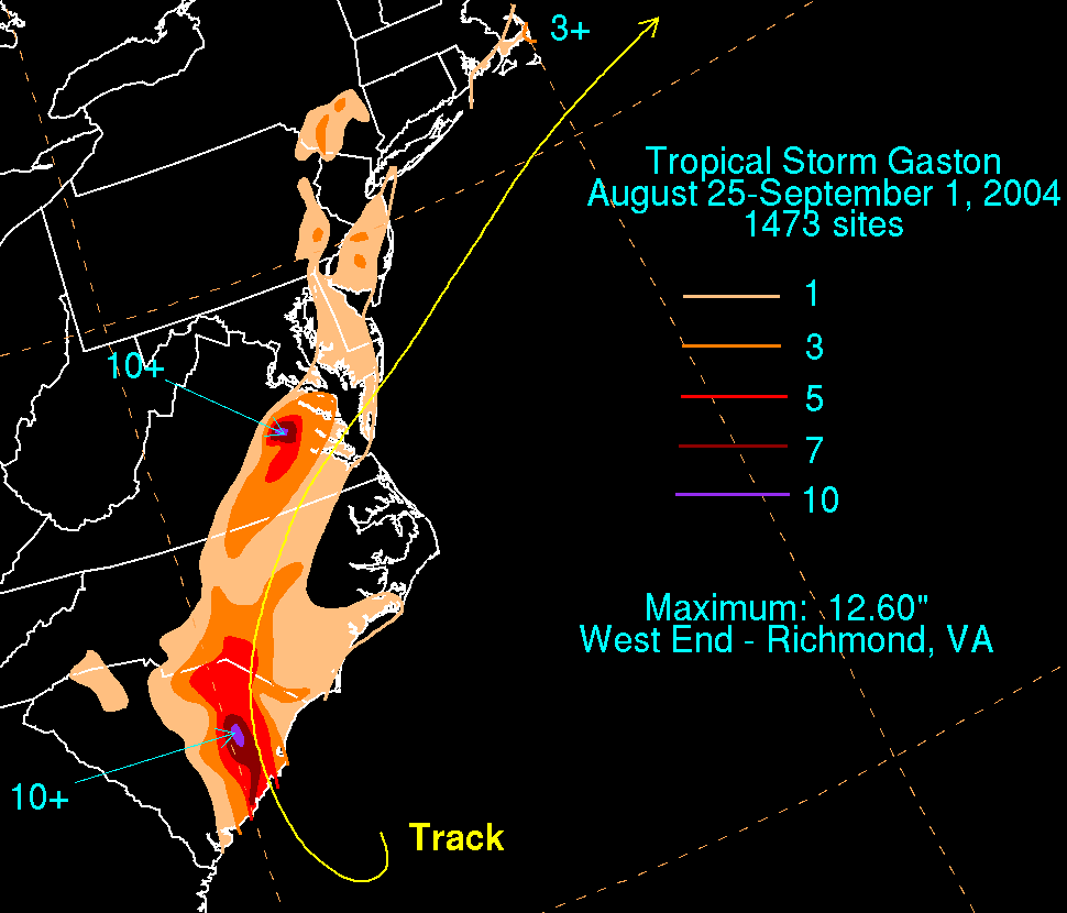
Severe weather is a concern in Virginia. Hurricanes make the coastal area of Virginia vulnerable. Hurricane Isabel in 2003 brought much destruction from wind and rain, killing 10 directly and doing nearly two billion dollars in damage. Hurricane Gaston in 2004 inundated Richmond after moving ashore South Carolina.[24] Virginia is often struck with the remnants of systems which hit along the Gulf of Mexico coastline, which also bring torrential rain to the state. Hurricane Camille was an extreme example, bringing 27 inches (690 mm) of rainfall to portions of Nelson County in a matter of hours.[25] Thunderstorms are an occasional concern with the state averaging anywhere from 35 to 45 days of thunderstorm activity annually.[26]
Rainfall in Virginia is frequent, but does not normally get severe enough for floods. Virginia averages seven tornadoes annually, though most are F2 and lower on the Fujita scale.[27] However, Virginia had eighty-five in 2004.[28] Western Virginia has a lower rate of tornadoes.[29]
Climate change
[edit]
Climate change in Virginia encompasses the effects of climate change, attributed to man-made increases in atmospheric carbon dioxide, in the U.S. state of Virginia.
The United States Environmental Protection Agency reports:
"Virginia's climate is changing. Most of the state has warmed about one degree (F) in the last century, and the sea is rising one to two inches every decade. Higher water levels are eroding beaches, submerging low lands, exacerbating coastal flooding, and increasing the salinity of estuaries and aquifers. The southeastern United States has warmed less than most of the nation. But in the coming decades, the region's changing climate is likely to reduce crop yields, harm livestock, increase the number of unpleasantly hot days, and increase the risk of heat stroke and other heat-related illnesses".[30]Seasons
[edit]Winter in Virginia is characterized by large swings in temperature throughout and between days. This does not happen every day of the month, however. It may be 50°F and windy one morning, and 70°F and calm the next afternoon. Winters are cool; temperatures usually range from the 40s to the 60s Fahrenheit in December; while in January, it typically is at or below freezing, especially in the mountains and the north, but can still be mild in the eastern and southern parts of the state, with temperatures in the 50s and 60s not uncommon. Snowfall is highly variable, occurring more heavily in some years, while in others it can be almost nonexistent. The most snow-prone region of the state is the Blue Ridge. Significant snowfall is most likely in Northern Virginia.
In the summer, temperatures are hot and humid. Precipitation is slightly greater. Temperatures are not extreme, ranging between the high 70s and mid 90s; but humidity can make it feel hotter.
As for sunlight, Virginia is about average in state rankings.[31] Areas on the Chesapeake Coast and Eastern Shore are brightest, while the west and north of the state is more cloudy. On the Winter Solstice, Virginia gets between 9 and 10 hours of sunlight. On the summer solstice, it gets between 14.5 and 15 hours.
See also
[edit]Notes
[edit]- ^ Mean monthly maxima and minima (i.e. the expected highest and lowest temperature readings at any point during the year or given month) calculated based on data at said location from 1991 to 2020.
- ^ Official records for Lynchburg were kept at the Weather Bureau Office from January 1893 to July 1944, and at Lynchburg Regional since August 1944. For more information, see ThreadEx
- ^ Mean monthly maxima and minima (i.e. the expected highest and lowest temperature readings at any point during the year or given month) calculated based on data at said location from 1991 to 2020.
- ^ Official records for Norfolk kept January 1874 to December 1945 at the Weather Bureau Office in downtown, and at Norfolk Int'l since January 1946. For more information, see Threadex.
- ^ Mean monthly maxima and minima (i.e. the expected highest and lowest temperature readings at any point during the year or given month) calculated based on data at said location from 1991 to 2020.
- ^ Official records for Richmond kept January 1887 to December 1910 at downtown, Chimborazo Park from January 1911 to December 1929, and at Richmond Int'l since January 1930. For more information, see Threadex
- ^ Mean monthly maxima and minima (i.e. the expected highest and lowest temperature readings at any point during the year or given month) calculated based on data at said location from 1991 to 2020.
- ^ Official records for Washington, D.C. were kept at 24th and M Streets NW from January 1872 to June 1945, and at Reagan National Airport since July 1945.[16]
- ^ Mean monthly maxima and minima (i.e. the expected highest and lowest temperature readings at any point during the year or given month) calculated based on data at said location from 1991 to 2020.
References
[edit]- ^ "World Map of Köppen−Geiger Climate Classification" (PDF). Archived from the original (PDF) on January 14, 2009. Retrieved 2008-12-19.
- ^ Shell, Eddie Wayne (2013). Evolution of the Alabama Agroecosystem: Always Keeping Up, but Never Catching Up. NewSouth Books. ISBN 978-1-60306-203-9.
- ^ "Climate of Virginia". Charles A. Grymes. Archived from the original on 2007-10-06. Retrieved 2007-07-30.
- ^ "Virginia Extremes". climate.virginia.edu. Retrieved 2017-02-04.
- ^ "NowData – NOAA Online Weather Data". National Oceanic and Atmospheric Administration. Retrieved June 28, 2025.
- ^ "Station: Lynchburg RGNL AP, VA". U.S. Climate Normals 2020: U.S. Monthly Climate Normals (1991–2020). National Oceanic and Atmospheric Administration. Retrieved July 2, 2021.
- ^ "WMO Climate Normals for LYNCHBURG WSO AP, VA 1961–1990". National Oceanic and Atmospheric Administration. Archived from the original on 2020-03-13. Retrieved March 11, 2014.
- ^ "NowData – NOAA Online Weather Data". National Oceanic and Atmospheric Administration. Retrieved May 18, 2021.
- ^ "Station: NORFOLK INTL AP, VA". U.S. Climate Normals 2020: U.S. Monthly Climate Normals (1991–2020). National Oceanic and Atmospheric Administration. Retrieved May 18, 2021.
- ^ "WMO Climate Normals for NORFOLK/INTL, VA 1961–1990". National Oceanic and Atmospheric Administration. Retrieved July 29, 2020.
- ^ "Norfolk, Virginia, USA - Monthly weather forecast and Climate data". Weather Atlas. Retrieved July 3, 2019.
- ^ "NowData – NOAA Online Weather Data". National Oceanic and Atmospheric Administration. Archived from the original on September 5, 2015. Retrieved May 4, 2021.
- ^ "Summary of Monthly Normals 1991–2020". National Oceanic and Atmospheric Administration. Archived from the original on May 5, 2021. Retrieved May 4, 2021.
- ^ "WMO Climate Normals for Richmond/Byrd, VA 1961–1990". National Oceanic and Atmospheric Administration. Archived from the original on 2024-02-16. Retrieved July 29, 2020.
- ^ "Richmond, VA - Detailed climate information and monthly weather forecast". Weather Atlas. Yu Media Group. Archived from the original on June 29, 2019. Retrieved June 29, 2019.
- ^ "Threaded Station Extremes". threadex.rcc-acis.org.
- ^ "WMO Climate Normals for WASHINGTON DC/NATIONAL ARPT VA 1961–1990". National Oceanic and Atmospheric Administration. Retrieved July 18, 2020.
- ^ "NowData – NOAA Online Weather Data". National Oceanic and Atmospheric Administration. Retrieved October 31, 2024.
- ^ "Summary of Monthly Normals 1991–2020". National Oceanic and Atmospheric Administration. Retrieved May 4, 2021.
- ^ "Washington, DC - Detailed climate information and monthly weather forecast". Weather Atlas. Yu Media Group. Retrieved June 29, 2019.
- ^ "NowData – NOAA Online Weather Data". National Oceanic and Atmospheric Administration. Retrieved July 5, 2021.
- ^ "Station: Washington DC DULLES AP, VA". U.S. Climate Normals 2020: U.S. Monthly Climate Normals (1991–2020). National Oceanic and Atmospheric Administration. Retrieved July 5, 2021.
- ^ "WMO Climate Normals for WASHINGTON DC/DULLES INT'L AR, VA 1961–1990". National Oceanic and Atmospheric Administration. Retrieved May 4, 2015.
- ^ David M. Roth. Hurricane Gaston Rainfall Graphic. Hydrometeorological Prediction Center. Retrieved on 2008-01-13.
- ^ David M. Roth. Hurricane Camille Rainfall Page. Hydrometeorological Prediction Center. Retrieved on 2008-01-13.
- ^ "History: Thunderstorms & Lightning". Virginia Department of Emergency Management. Archived from the original on 5 March 2017. Retrieved 4 March 2017.
- ^ Ricketts, Lauryn (February 7, 2008). "Tornadoes DO happen in Virginia!". TV3 Winchester. Archived from the original on March 14, 2010. Retrieved 2009-02-13.
- ^ "Natural Hazards : Tornadoes". Virginia Business Emergency Survival Toolkit. 2007. Archived from the original on 2007-07-05. Retrieved 2007-11-29.
- ^ "Tornado History Project: Virginia". www.tornadohistoryproject.com. Retrieved 2017-02-03.[dead link]
- ^ "What Climate Change Means for Virginia" (PDF). United States Environmental Protection Agency. August 2016.
- ^ "Sunniest States 2021".
External links
[edit]Climate of Virginia
View on GrokipediaGeographical and Climatic Classification
Overall Climate Type
Virginia's climate is predominantly classified as humid subtropical under the Köppen system (Cfa), encompassing the majority of the state east of the Blue Ridge Mountains, including the coastal plain, Piedmont, and southern Shenandoah Valley.[1][7] This classification is defined by hot, humid summers with average temperatures exceeding 72°F (22°C) in the warmest month, mild winters where the coldest month averages above 32°F (0°C) but below 64°F (18°C), and no pronounced dry season, with precipitation distributed throughout the year exceeding potential evapotranspiration.[1] The humid subtropical regime results from Virginia's mid-latitude position, influenced by warm Atlantic Ocean currents and frequent moist air masses from the Gulf of Mexico, leading to annual precipitation averages of 40-50 inches across much of the state.[9] Summers typically feature high humidity and temperatures often reaching 90°F (32°C) or higher, while winters bring occasional cold fronts with snowfall varying from minimal in the east to heavier in elevated areas.[9] This climate supports diverse agriculture, including tobacco, soybeans, and orchards, but also contributes to risks of heat waves and flooding.[7] In higher elevations of the Appalachians and western mountains, the climate transitions to humid continental (Dfa) or subtropical highland variants, characterized by cooler summers and more severe winters due to orographic effects and reduced maritime influence.[1] Despite these variations, the humid subtropical type dominates, shaping the state's overall mild mid-latitude profile with four distinct seasons.[7]Regional Climate Zones
Virginia's climate exhibits significant regional variations driven by physiographic provinces, including the Coastal Plain, Piedmont, Blue Ridge Mountains, Valley and Ridge, and Appalachian Plateau, which influence temperature ranges, precipitation patterns, and seasonal extremes through factors such as elevation, proximity to the Atlantic Ocean, and topographic barriers to airflow.[9] Under the Köppen-Geiger classification, the majority of the state falls within the humid subtropical (Cfa) zone, characterized by hot, humid summers and mild winters with no distinct dry season, but transitions occur westward due to increasing elevation and continental influences.[1] These zones reflect causal effects of geography: coastal moderation tempers extremes in the east, while orographic lift in mountains enhances cooling and rainfall.[10] In the eastern Coastal Plain (Tidewater region, the humid subtropical climate is ameliorated by the Chesapeake Bay and Atlantic Ocean, yielding average January temperatures around 40°F (4°C) and July highs near 88°F (31°C), with annual precipitation exceeding 45 inches (114 cm), much of it from convective thunderstorms and nor'easters.[4] This area experiences the state's mildest winters, with rare snowfall accumulations below 5 inches (13 cm) annually, and persistent humidity fostering fog and dew points often above 70°F (21°C) in summer.[11] The Piedmont region, a rolling upland plateau inland from the Coastal Plain, maintains a Cfa classification but displays more continental traits, with summer highs frequently surpassing 90°F (32°C) and winter lows dipping to 25°F (-4°C), alongside slightly lower precipitation averaging 40-45 inches (102-114 cm) yearly due to reduced maritime influence.[4] Temperature variability increases here, as the Fall Line escarpment disrupts airflow, leading to sharper diurnal swings and occasional frost pockets in valleys.[11] Westward, the Blue Ridge Mountains and Appalachian provinces shift toward subtropical highland (Cfb) or humid continental (Dfa/Dfb) subtypes at elevations above 2,000 feet (610 m), where cooler summers average below 75°F (24°C) and winters bring more frequent freezes and snowfall totals up to 30 inches (76 cm) or higher in the highest ridges, such as Mount Rogers at 5,729 feet (1,746 m).[1] Precipitation intensifies to 50-60 inches (127-152 cm) annually from orographic enhancement, supporting denser forests but also elevating risks of flash flooding and landslides.[9] Northern Virginia's urbanized Piedmont extensions and the Shenandoah Valley exhibit transitional traits, blending Piedmont heat with valley fog and moderated mountain effects.[4]Seasonal Characteristics
Summer Conditions
Summers in Virginia, spanning June through August, feature warm to hot temperatures influenced by the subtropical high-pressure system known as the Bermuda High, which promotes humid conditions across much of the state. Statewide average temperatures reach approximately 75°F (24°C) in July, the warmest month.[9] Eastern regions, including the coastal plain and Piedmont, experience average July highs of 85–90°F (29–32°C) and lows of 65–72°F (18–22°C), with cities like Richmond and Norfolk recording daily highs around 90°F (32°C).[12] [13] In contrast, the Appalachian Mountains in western Virginia moderate summer heat, with average July highs of 80–85°F (27–29°C) and lows near 60°F (16°C), as seen in locations like Abingdon.[12] High relative humidity, often 70–80% in the mornings during July, exacerbates perceived temperatures through elevated heat indices, frequently surpassing 100°F (38°C) in lowland areas during heat waves.[14] Summer temperatures occasionally exceed 100°F (38°C), particularly in the southeast, where the combination of solar heating and moisture from the Atlantic contributes to muggy conditions.[15] Precipitation averages 3–4 inches per month, driven primarily by frequent afternoon thunderstorms fueled by convective instability and sea breeze fronts along the coast.[9] These patterns result from Virginia's position in a humid subtropical climate zone (Köppen Cfa), where warm moist air masses dominate, leading to diurnal heating cycles that trigger localized storms.[9] While eastern Virginia endures prolonged humid heat, mountainous terrain provides orographic cooling and occasional relief from extreme highs, though humidity remains notable statewide.[12] Heat-related advisories are common, with historical data indicating upper 90s°F (32–35°C) as typical peaks in urban areas like Arlington.[12]Winter Conditions
Winters in Virginia, spanning December through February, feature cool to cold temperatures moderated by the state's mid-latitude position and proximity to the Atlantic Ocean, with statewide January averages around 35°F. Regional variations are pronounced: coastal Tidewater areas, such as Norfolk, record average January highs near 50°F and lows around 32°F, while Appalachian Mountain regions, like those near Wise, experience averages dipping to 30°F or below with frequent sub-freezing nights. Piedmont and Northern Virginia locales, including Richmond and Dulles, typically see January highs of 45–50°F and lows of 25–30°F.[9] Precipitation during winter often arrives as a mix of rain, sleet, freezing rain, and snow, influenced by cyclonic storms tracking from the Gulf of Mexico or nor'easters off the Atlantic. Average winter snowfall statewide approximates 10–15 inches annually, concentrated in these months, though distribution varies sharply by topography and elevation. Coastal and southeastern regions receive under 5 inches per year, with events rare and light; central Piedmont areas average 8–15 inches; and western mountainous zones, particularly the Appalachian Plateau, accumulate 30–50 inches or more, as in Wise County where annual totals exceed 52 inches due to orographic lift enhancing snow persistence.[16][17] Cold snaps, driven by Arctic air outbreaks, can plunge temperatures below 0°F in higher elevations, while ice storms pose hazards statewide from supercooled droplets forming glaze on surfaces. Freezing rain events, common in transitional zones between warm and cold air masses, have historically disrupted infrastructure, as documented in National Weather Service records. Despite overall mildness relative to northern states, interannual variability is high, with El Niño/La Niña patterns modulating storm tracks and severity.Transitional Seasons
Spring in Virginia, spanning March through May, marks a period of rapid warming as continental polar air masses yield to warmer southerly flows, resulting in average statewide temperatures rising from about 45°F in March to 65°F in May.[9] In central locations like Richmond, monthly averages show highs increasing from 57°F to 75°F and lows from 35°F to 53°F, with precipitation totaling around 10–12 inches over the season, primarily from frequent frontal passages and developing thunderstorms.[18] Eastern coastal areas experience milder conditions due to maritime moderation, while Appalachian regions see greater diurnal swings and occasional late frosts into April, with risks of severe weather including hail and high winds from unstable spring atmospheres.[19] Autumn, from September to November, features gradual cooling with statewide averages declining from roughly 70°F in September to 50°F in November, driven by strengthening northerly gradients and diminishing tropical influences.[9] Precipitation remains steady at 9–11 inches seasonally, often in the form of scattered showers or remnants of Atlantic systems, though October typically sees the driest conditions in inland valleys.[18] In Richmond, highs drop from 79°F to 57°F and lows from 60°F to 37°F, with clear skies enhancing visibility for peak foliage displays in the Blue Ridge Mountains around mid-October, where cooler elevations accelerate color changes in deciduous hardwoods.[7] Both seasons exhibit high interannual variability, with temperature anomalies of ±5°F common due to jet stream positioning, contrasting the more stable summer and winter patterns.[9]Meteorological Data
Temperature Patterns
Virginia's temperature patterns reflect its humid subtropical climate, with hot, humid summers and cool to mild winters that vary markedly by region due to elevation, latitude, and maritime influence. Coastal areas, moderated by the Atlantic Ocean, experience milder winters and slightly warmer overall temperatures, while the Appalachian Mountains in the west feature cooler conditions year-round, with greater diurnal ranges and lower extremes influenced by higher elevations up to 5,729 feet (1,746 m) at Mount Rogers. Piedmont regions, including central areas like Richmond, serve as transitional zones with intermediate temperatures. Statewide, July marks the warmest month with mean temperatures averaging 75–80°F (24–27°C), while January is coldest at 35–45°F (2–7°C), based on 1991–2020 normals from NOAA stations.[9] In the Tidewater and coastal zones, such as Norfolk, average July highs reach near 90°F (32°C) with lows around 70°F (21°C), reflecting high humidity and occasional sea breezes that temper peaks but prolong warmth. Winters here are relatively mild, with January highs near 50°F (10°C) and lows near 30°F (−1°C), rarely dropping below freezing for extended periods. Mountainous areas, conversely, see July highs averaging 75–80°F (24–27°C) but January means below 30°F (−1°C), with lows often in the teens, exacerbated by radiative cooling and topographic sheltering from southerly winds. These regional disparities result in annual temperature gradients of 10–15°F cooler in the west compared to the southeast, driven primarily by orographic effects rather than latitude alone, as confirmed by NOAA divisional data.[9][20] Representative monthly normals from Richmond International Airport (1991–2020) illustrate central Virginia's patterns, with a marked seasonal cycle: summer means exceeding 75°F (24°C) from June to August, and winter means below 45°F (7°C) from December to February. Diurnal ranges peak in summer at 20–25°F (11–14°C), narrowing in winter due to cloud cover and frontal passages.| Month | Mean High (°F) | Mean Low (°F) | Mean (°F) |
|---|---|---|---|
| Jan | 47.8 | 28.8 | 38.3 |
| Feb | 51.6 | 30.4 | 41.0 |
| Mar | 59.6 | 37.2 | 48.4 |
| Apr | 70.4 | 46.4 | 58.4 |
| May | 77.8 | 55.7 | 66.7 |
| Jun | 85.6 | 64.5 | 75.0 |
| Jul | 89.5 | 69.2 | 79.4 |
| Aug | 87.5 | 67.6 | 77.5 |
| Sep | 81.2 | 61.1 | 71.2 |
| Oct | 70.9 | 49.0 | 60.0 |
| Nov | 60.4 | 38.8 | 49.6 |
| Dec | 51.5 | 32.1 | 41.8 |
Precipitation and Humidity
Virginia's annual precipitation averages 44.3 inches statewide, with regional variations influenced by topography and proximity to the Atlantic Ocean; coastal and southeastern areas receive over 45 inches, while the Shenandoah Valley and western mountains see less than 40 inches due to rain shadow effects from the Appalachians.[9][22] Measurable precipitation occurs on approximately 110 days per year across the state, reflecting frequent but moderate events rather than concentrated seasonal downpours.[7] Precipitation distribution is relatively uniform across seasons, lacking the pronounced winter maxima of Pacific-influenced climates or summer droughts of continental interiors; however, summer (June-August) contributes slightly more through convective thunderstorms driven by diurnal heating and instability, while autumn (September-November) sees elevated totals from tropical cyclone remnants, accounting for 10-40% of September rainfall in vulnerable areas.[4] Winter and spring events are often frontal, yielding steady rain or snowmelt, with statewide averages around 3-4 inches per month in Piedmont and coastal zones, decreasing westward.[5] For example, Richmond records about 43.1 inches annually (1991-2020 normals), Norfolk around 50 inches due to maritime influences, and Roanoke 45 inches with orographic enhancement in the Valley and Ridge province.[23][24][25]| City/Region | Annual Average (inches) | January Average (inches) | July Average (inches) |
|---|---|---|---|
| Statewide | 44.3 | ~3.5 | ~4.5 |
| Richmond (Piedmont) | 43.1 | ~3.0 | ~4.5 |
| Norfolk (Coastal) | 50.0 | ~3.5 | ~5.0 |
| Roanoke (Southwest) | 45.0 | ~3.0 | ~4.0 |