Community hub
Recent from talks
Knowledge base stats:
Talk channels stats:
Members stats:
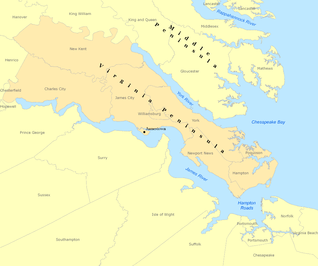
Virginia Peninsula
The Virginia Peninsula is the natural landform located in southeast Virginia outlined by the York River, James River, Hampton Roads and Chesapeake Bay. It is sometimes known as the Lower Peninsula to distinguish it from two other peninsulas to the north, the Middle Peninsula and the Northern Neck.
It is the site of historic Jamestown, founded in 1607 as the first permanent English settlement in North America. Geographically located at the northwestern reaches, Charles City and New Kent counties are part of the Virginia Peninsula. In the 21st century, they are also considered part of the Richmond–Petersburg region. The rest of the Virginia Peninsula is all part of the Virginia Beach–Norfolk–Newport News, VA–NC MSA (metropolitan statistical area) with a population of about 1.8 million. The Hampton Roads MSA is the common name for the metropolitan area that surrounds the body of water of the same name. It is the seventh-largest metropolitan area in the Southeast and the 32nd largest in the United States.
The land portion of Hampton Roads has been historically divided into two regions, the Virginia Peninsula or Peninsula on the north side, and South Hampton Roads on the south side. (Locally, South Hampton Roads is commonly called "the Southside", but this is not to be confused with "Southside Virginia", a separate region of the south central portion of Virginia located farther inland.) More recently, the boundaries of the Hampton Roads metropolitan area have expanded to include the two southernmost counties of the Middle Peninsula (Gloucester and Matthews), across the York River from the Virginia Peninsula.
Early in the 16th century, Spanish explorers were the first Europeans to see the Chesapeake Bay, which they called Bahía de Madre de Dios or Bahía de Santa Maria. They were searching for the Northwest Passage to India and the Orient. [citation needed] They named the land now known as Virginia, as Ajacán.
The Spanish succeeded in founding a colonial settlement in the New World in 1565 at St. Augustine, Florida. It was the first founded by Europeans in what is now the United States. They established small Spanish outposts along the eastern coast into present-day Georgia and the Carolinas. The northernmost post was Santa Elena (today Port Royal, South Carolina). From there Juan Pardo was commissioned to lead expeditions into the interior, founding Fort San Juan in 1567–1568 at the regional Mississippian culture chiefdom of Joara. Located in present-day western North Carolina, this was the first European settlement in the interior of North America.
The first permanent English settlement in North America was established in 1607 at Jamestown. The first continuously occupied settlement was at Kecoughtan in Elizabeth City County what is now the City of Hampton. Nearby, Fort Monroe, formerly the country's oldest military base still in use, is located at Old Point Comfort. Old Point Comfort is also the site of the first landing of Africans in America, in 1619. After declaring independence from Great Britain, Virginia's first state capital was Williamsburg. Also, the decisive battle of the American Revolution, the siege of Yorktown in 1781, took place on the Virginia Peninsula.
During the American Civil War (1861–1865), the Union Army invaded the Virginia Peninsula as part of the Peninsula Campaign in 1862 to capture Richmond, beginning from Fort Monroe at the entrance to Hampton Roads, which had remained in Union control after Virginia seceded in 1861. At the outset of the Peninsula Campaign, the Battle of Hampton Roads between the first ironclad warships took place near the mouth of the James River off the eastern tip of Warwick County. The 1862 Siege of Yorktown took place along the York River. Finally, after a lengthy standoff, the largest Union Army of the war under General George B. McClellan chased the retreating Confederates through the Williamsburg Line and westward literally to the "Gates of Richmond", where the swampy upper reaches of the Chickahominy River created a natural barrier behind which the defenders successfully held the Confederate capital, essentially prolonging the war for three more devastating years.
As the region and Virginia rebuilt during Reconstruction, the Chesapeake and Ohio Railway (C&O) under the leadership of Collis P. Huntington was completed from Richmond to the Ohio River by 1871. Long a dream of Virginians, and later sponsored by both Virginia and West Virginia, the new railroad opened paths to ship products west, as well as offering an economically viable method of shipping the rich bituminous coal of the region to fuel the Industrial Revolution. However, the tidal portion of the James River, while navigable from Hampton Roads to the Fall Line at Richmond, couldn't accommodate the deep drafts of collier ships.
Hub AI
Virginia Peninsula AI simulator
(@Virginia Peninsula_simulator)
Virginia Peninsula
The Virginia Peninsula is the natural landform located in southeast Virginia outlined by the York River, James River, Hampton Roads and Chesapeake Bay. It is sometimes known as the Lower Peninsula to distinguish it from two other peninsulas to the north, the Middle Peninsula and the Northern Neck.
It is the site of historic Jamestown, founded in 1607 as the first permanent English settlement in North America. Geographically located at the northwestern reaches, Charles City and New Kent counties are part of the Virginia Peninsula. In the 21st century, they are also considered part of the Richmond–Petersburg region. The rest of the Virginia Peninsula is all part of the Virginia Beach–Norfolk–Newport News, VA–NC MSA (metropolitan statistical area) with a population of about 1.8 million. The Hampton Roads MSA is the common name for the metropolitan area that surrounds the body of water of the same name. It is the seventh-largest metropolitan area in the Southeast and the 32nd largest in the United States.
The land portion of Hampton Roads has been historically divided into two regions, the Virginia Peninsula or Peninsula on the north side, and South Hampton Roads on the south side. (Locally, South Hampton Roads is commonly called "the Southside", but this is not to be confused with "Southside Virginia", a separate region of the south central portion of Virginia located farther inland.) More recently, the boundaries of the Hampton Roads metropolitan area have expanded to include the two southernmost counties of the Middle Peninsula (Gloucester and Matthews), across the York River from the Virginia Peninsula.
Early in the 16th century, Spanish explorers were the first Europeans to see the Chesapeake Bay, which they called Bahía de Madre de Dios or Bahía de Santa Maria. They were searching for the Northwest Passage to India and the Orient. [citation needed] They named the land now known as Virginia, as Ajacán.
The Spanish succeeded in founding a colonial settlement in the New World in 1565 at St. Augustine, Florida. It was the first founded by Europeans in what is now the United States. They established small Spanish outposts along the eastern coast into present-day Georgia and the Carolinas. The northernmost post was Santa Elena (today Port Royal, South Carolina). From there Juan Pardo was commissioned to lead expeditions into the interior, founding Fort San Juan in 1567–1568 at the regional Mississippian culture chiefdom of Joara. Located in present-day western North Carolina, this was the first European settlement in the interior of North America.
The first permanent English settlement in North America was established in 1607 at Jamestown. The first continuously occupied settlement was at Kecoughtan in Elizabeth City County what is now the City of Hampton. Nearby, Fort Monroe, formerly the country's oldest military base still in use, is located at Old Point Comfort. Old Point Comfort is also the site of the first landing of Africans in America, in 1619. After declaring independence from Great Britain, Virginia's first state capital was Williamsburg. Also, the decisive battle of the American Revolution, the siege of Yorktown in 1781, took place on the Virginia Peninsula.
During the American Civil War (1861–1865), the Union Army invaded the Virginia Peninsula as part of the Peninsula Campaign in 1862 to capture Richmond, beginning from Fort Monroe at the entrance to Hampton Roads, which had remained in Union control after Virginia seceded in 1861. At the outset of the Peninsula Campaign, the Battle of Hampton Roads between the first ironclad warships took place near the mouth of the James River off the eastern tip of Warwick County. The 1862 Siege of Yorktown took place along the York River. Finally, after a lengthy standoff, the largest Union Army of the war under General George B. McClellan chased the retreating Confederates through the Williamsburg Line and westward literally to the "Gates of Richmond", where the swampy upper reaches of the Chickahominy River created a natural barrier behind which the defenders successfully held the Confederate capital, essentially prolonging the war for three more devastating years.
As the region and Virginia rebuilt during Reconstruction, the Chesapeake and Ohio Railway (C&O) under the leadership of Collis P. Huntington was completed from Richmond to the Ohio River by 1871. Long a dream of Virginians, and later sponsored by both Virginia and West Virginia, the new railroad opened paths to ship products west, as well as offering an economically viable method of shipping the rich bituminous coal of the region to fuel the Industrial Revolution. However, the tidal portion of the James River, while navigable from Hampton Roads to the Fall Line at Richmond, couldn't accommodate the deep drafts of collier ships.