

Community hub
Recent from talks
Contribute something
Nothing was collected or created yet.
Quezon City
View on Wikipedia
Quezon City (UK: /ˈkeɪzɒn/, US: /ˈkeɪsɒn, -sɔːn, -soʊn/;[9][10][11][12] Filipino: Lungsod Quezon [luŋˈsod ˈkɛson] ⓘ), also known as the City of Quezon and Q.C. (read and pronounced in Filipino as Kyusi),[13][14][15] is the most populous city in the Philippines. According to the 2024 census, it has a population of 3,084,270 people. It was founded on October 12, 1939, and was named after Manuel L. Quezon, the second president of the Philippines. Quezon City served as the capital of the Philippines from 1948 until 1976, when the designation was returned to Manila.
Key Information


.svg)

The city was intended to be the national capital of the Philippines that would replace Manila, as the latter was suffering from overcrowding, lack of housing, poor sanitation, and traffic congestion. To create Quezon City, several barrios were carved out from the towns of Caloocan, Marikina, San Juan and Pasig, in addition to the eight vast estates the Philippine government purchased for this purpose. It was officially proclaimed the national capital on October 12, 1949, and several government departments and institutions moved out of Manila and settled into the new capital city. This necessitated the expansion of the city northward, carving out Novaliches from Caloocan which divided it into two non-contiguous parts. Several barrios were also taken from San Mateo and parts of Montalban. However, on June 24, 1976, Presidential Decree No. 940 was enacted, which reverted national capital status to Manila while the whole of Metro Manila was designated as the seat of government.[16][17] The city was also chosen as the regional center of Southern Tagalog, which was created in 1965, along with the provinces of Quezon and Aurora, the birthplace of Manuel L. Quezon; however, its status of regional center became ineffective when the region was divided into Calabarzon and Mimaropa, through the effect of Executive Order No. 103 in May 2002 under the presidency of Gloria Macapagal Arroyo, and Aurora was transferred to the authority of Central Luzon, with Southern Tagalog limited to being a cultural-geographic region.[18]
Quezon City is known for its culture, entertainment industry and media, and is aptly called the "City of Stars". Major broadcasting networks have their headquarters and studios in the city. It is also known for its commerce, education, research, technology, politics, tourism, art and sports. Several national government branches including the Batasang Pambansa Complex, the seat of House of Representatives of the Philippines, call the city home.
Quezon City is a planned city. It covers a total area of 161.11 square kilometers (62.20 sq mi),[5] making it the largest city in Metro Manila/NCR in terms of land area. It is politically subdivided into six congressional districts, which represent the city in the Lower House of the Congress of the Philippines. The city has 142 barangays under the City Government. National government departments and agencies are mostly situated in the first National Government Center (NGC) in Diliman. and the second National Government Center in Batasan Hills, where the Lower House of the Philippine Congress is located. Most of the city's northern part lies at the foothills of the Sierra Madre mountain range, including the La Mesa Watershed Reservation, the largest watershed in Metro Manila and a designated protected area.
According to its 2023 estimated census, Quezon City had 3.1 million people in its boundaries, and ₱1.27 trillion (US$93.8 billion)[citation needed] in its gross domestic product (GDP), and it is the only planned city in the National Capital Region of the Philippines.
History
[edit]Commonwealth era
[edit]Initial plans for a new capital city
[edit]
Before the creation of Quezon City, the land on where it would eventually rise was part of several towns such as Caloocan, Mariquina (Marikina), Montalban (renamed as Rodriguez), Pasig, San Mateo, and San Juan del Monte (renamed as San Juan), all under Manila province and, beginning in 1901, Rizal province.
In the 1930s, Manila's urban problems were apparent and problematic.[19] It lacked public housing, where thousands of the city's residents lived in congested informal settler communities, especially in the central districts of Binondo, Intramuros, Quiapo, San Nicolas and Tondo.[19] There were also problems with sanitation and traffic congestion.[19] The rise of slums in Manila gave rise to the development of its suburbs outside the city limits in the municipalities of Pasay, San Felipe Neri (renamed as Mandaluyong), San Francisco del Monte, Makati, and San Juan del Monte.[19] These towns became favorable to the upper and middle-class who wanted to escape the congested city but had economic links to it.[19]
President Manuel L. Quezon, aware of the problems besetting Manila, initiated housing projects called Barrio Obrero (Worker's Community).[19] These communities were established in various places in Manila such as Avenida Rizal, Sta. Cruz and Barrio Vitas, Tondo.[19] However, the project failed miserably and these communities became slum areas.[19]
Alejandro Roces Sr., a prominent Filipino author, was said to be influential in Quezon's vision to establish a new city.[19] Quezon dreamed of a city where the common people could live and thrive.[19] Roces suggested that a sizeable tract of land be purchased for this purpose.[19] However, the government had no available fund except for ₱3 million in the hands of the National Development Company (NDC).[19]

In order to make Quezon's dream a reality and to mobilize funds for the land purchase, the People's Homesite Corporation (PHC) was created on October 14, 1938, as a subsidiary of NDC, with an initial capital of ₱2 million.[19] Roces was the chairman of the Board of PHC, and they immediately acquired the vast Diliman Estate of the Tuason family at a cost of 5 centavos per square meter.[19] PHC conducted topographical and subdivision surveys, and then subdivided the lots and sold them to the target buyers at an affordable price.[19] Its target users and beneficiaries were Manila's working class,[20] who were suffering from a shortage of affordable and decent housing in the capital.[19] The service of the Metropolitan Waterworks system was extended to site.[19] The Bureau of Public Works, then under Secretary Vicente Fragante, constructed the streets and highways within the property.[19] Quezon also tapped Architect Juan M. Arellano to draft a design of the city.[19] Eight vast estates were acquired in order to create Quezon City: Diliman Estate, 1,573.22 hectares (15.7322 km2), Santa Mesa Estate, 861.79 hectares (8.6179 km2), Mandaluyong Estate, 781.36 hectares (7.8136 km2), Magdalena Estate, 764.48 hectares (7.6448 km2), Piedad Estate, 743.84 hectares (7.4384 km2), Maysilo Estate, 266.73 hectares (2.6673 km2) and the San Francisco Del Monte Estate, 257.54 hectares (2.5754 km2).[19] Quezon's goal was to create a place for the working class, coinciding with the planned transfer of the University of the Philippines campus in Manila to a more suitable location, which became another precedent for the creation of Quezon City.[19]
As early as 1928, the University of the Philippines (UP) had planned to expand by adding more academic units and constructing new buildings.[19] The university experienced increase in enrollment and its planned expansion was hampered by its small campus in Manila.[21] The revised Burnham Plan of Manila envisioned the new campus to be located just outside Manila's city limits at 'the heights behind Manila'.[19] The UP Board of Regents informed Quezon of their desire to relocate the campus and he was supportive of the idea.[19] Furthermore, he wanted the facilities in the Manila campus to be used for government purposes.[19] In 1939, Quezon urged the National Assembly to enact UP's relocation and on June 8, 1939, Commonwealth Act No. 442 was passed, enacting the transfer of UP outside of Manila.[22] A portion of Mariquina Estate, which was adjacent to Magdalena Estate, was chosen as the new site with an approximate area of 600 hectares (1,500 acres).[19] Additional land from the Diliman Estate was also added as part of the new university campus.[19]
Creation of Quezon City
[edit](2018-02-07)_(cropped).jpg)
With the development of the People's Homesite Corporation housing in the Diliman Estate and the creation of the new UP Campus, the creation of Quezon City was justified.[19] On October 12, 1939, Commonwealth Act No. 502, also known as the Charter of Quezon City, was passed by the National Assembly, which created Quezon City.[23] Surprisingly, Quezon allowed the bill to lapse into law because he did not sign it.[19] The city was originally to be known as Balintawak City according to the first bill filed by Assemblyman Ramon P. Mitra Sr. from Mountain Province, but Assemblymen Narciso Ramos and Eugenio Perez, both from Pangasinan, amended and successfully lobbied the assembly to name the city after the President in honor of his role in the creation of this new city.[24][25][19] The creation of Quezon City halted the full implementation of the Burnham Plan of Manila and funds were diverted for the establishment of the new capital.
Several barangays from different towns were carved out to correspond to the estates that PHC bought for the creation of Quezon City.[19] The new city had an area of 7,355 hectares (73.55 km2), and the barrios and sitios that were taken for its creation were the following: Bagubantay (Bago Bantay), Balingasa, Balintauac (Balintawak), Kaingin, Kangkong, Loma (La Loma), Malamig, Matalahib, Masambong, San Isidro, San Jose, Santol and Tatalon, were taken from Caloocan;[26] Cubao, Diliman, Kamuning, New Manila, and San Francisco del Monte were taken from San Juan; Balara, Barranca (Barangka), Jesus de la Peña, Krus na Ligas, Tañong and the site of the new UP Campus were taken from Marikina; and, the barrios and sitios of Libis, and Ogong (Ugong Norte) from Pasig.[19] Commonwealth Act No. 659, enacted on June 21, 1941, changed the city's boundaries.[27] Under this law, the area of Wack Wack Golf and Country Club were to be reverted to Mandaluyong, and the barrios of lower Barranca and Jesus de la Peña were reverted to Marikina. However, Camp Crame was taken out of San Juan and was given to Quezon City.[19][27]
1939, the year the city was established, recorded a population of 39,103 people. The city in its early days was predominantly rural, but Quezon asked American Architect William Parsons to craft a master plan for the newly created city.[19] Parsons was the one who advised Quezon to locate the National Government Center in Diliman instead of Wallace Field (now Rizal Park), due to the possibility of naval bombardment from Manila Bay.[19] He died in December 1939 and his partner Harry T. Frost took over and become the lead planner.[19] Frost arrived in the Philippines on May 1, 1940, and became the architectural adviser of the Philippine Commonwealth government.[19] Together with Juan M. Arellano, Alpheus D. Williams, and Welton Becket, they created the Master Plan for Quezon City which was approved by the Philippine government in 1941.[19] The Frost Plan featured wide avenues, large open spaces, and roundabouts at major intersections.[19] The plan for major thoroughfares made by Louis Croft for the Greater Manila Area served as the backbone for the Plan of Quezon City.[19] The center of the city was a 400-hectare (990-acre) quadrangle formed by four avenues — North, West, South and East — which was designed to be the location of the National Government of the Philippines.[28] At the northeast corner of the Quadrangle was a large roundabout, a 25-hectare (62-acre) elliptical site, were the proposed Capitol Building is envisioned to rise.[19]
To make the city accessible, Quezon ordered Luzon Bus Lines to ply from Kamuning towards Tutuban in Divisoria, Manila to provide transport for the city's residents. However, the fare was not affordable to minimum wage earners. Because of the city's unaffordable housing prices and lack of transportation for low-income earners, the goal of creating mass housing for the working class was not met. Instead, those who opted to live in Quezon City consisted of middle-class households such as those in Kamuning, whose residents petitioned to rename it from Barrio Obrero (Worker's Community) to Kamuning (a type of tree that grows abundantly in the area) because its residents were not Obreros (Workers).[19]
Japanese occupation
[edit]
The Philippine Exposition in 1941 was held on the newly established Quezon City, but participants were limited to locals because of the increasing turbulence at the beginning of the Second World War.[19] Eventually, parts of Manila were bombed by the Japanese Imperial Forces in December 1941, bringing the war to the Philippines. On January 1, 1942, President Quezon issued Executive Order No. 400 as an emergency measure to form the City of Greater Manila, with Jorge B. Vargas as its designated mayor. It merged the city with Manila and the towns of Caloocan, Makati, Mandaluyong, Parañaque, Pasay, and San Juan. The mayors of these towns and cities served as the assistant mayor of their respective localities and were under the mayor of Greater Manila.[29][30] The City of Greater Manila was the basis for the formation of Metro Manila in 1975.
After Imperial Japanese forces conquered the Philippines during the Pacific War, the City of Greater Manila was reorganized in 1942 into twelve districts, two of which were formed by dividing Quezon City: Balintawak which consisted of San Francisco del Monte, Galas, La Loma, New Manila, Santa Mesa Estate, the Wack Wack Golf and Country Club, and the present-day Greenhills, San Juan; and Diliman which was composed of Diliman proper, Cubao, the University District, and the present-day eastern portion of Marikina.[31] In the same year, the patients of Quezon Institute were relocated to the San Juan de Dios Hospital in Intramuros and the Japanese military used the facility for its own sick and wounded, and they also used Saint Joseph's College as a hospital. The Imperial Japanese Army Air Service's Twenty-ninth Squadron equipped with Ki-44 and Ki-84 fighter planes was assigned to Zablan Field of Camp Murphy. This colonial airfield was modernized by the Japanese with the construction of longer concrete runways, which now form the southernmost part of Katipunan Avenue and White Plains Avenue. The Japanese also renamed some streets, most notably South Avenue which became Timog Avenue. On the morning of 21 September 1944, Zablan Field and three other Japanese airfields in Greater Manila were attacked by American carrier aircraft, which caused President Laurel to issue declarations of martial law and of war. In January 1945, when the Americans returned to mainland Luzon, they gave numerical designations to some roads such as Route 54, which is now Epifanio de los Santos Avenue. In February, the American cavalry and Filipino guerrilla units, advanced into Quezon City, defeating Imperial Japanese forces. Heavy fighting occurred in Novaliches, which at that time was within Caloocan, and New Manila which had been fortified. Smaller actions were fought at Barrio Talipapa and the University District, and the destruction of the bridge on the Tullahan River delayed the advance of the Americans along Route 52, now known as Quirino Highway. After the Battle of Manila, the City of Greater Manila was dissolved by President Sergio Osmeña, thus separating the cities and towns that were consolidated and regaining their pre-war status.[32] The area which formed the city was then governed by the Philippine Executive Commission.
The postwar and independence era
[edit]
Existing territorial boundaries
Detached by Commonwealth Act No. 502 (1939)
Novaliches area; detached by Republic Act No. 392 (1949)
On July 17, 1948, President Elpidio Quirino signed Republic Act No. 333 into law, making Quezon City the capital of the Philippines.[33] The Act created the Capital City Planning Commission, which was tasked to develop and implement a masterplan for the city.[5] As the capital, the city was expanded northwards, and the barrios of Baesa, Bagbag, Banlat, Kabuyao, Novaliches Proper (Bayan/Poblacion), Pasong Putik, Pasong Tamo, Pugad Lawin, San Bartolome, and Talipapa in Novaliches were ceded from Caloocan. This territorial change caused the division of Caloocan into two non-contiguous parts.[5] Quezon City was formally inaugurated as the capital on October 12, 1949. President Quirino laid the cornerstone on the proposed Capitol Building at Constitution Hills.[5]
On June 16, 1950, the Quezon City Charter was revised by Republic Act No. 537, changing the city's boundaries to an area of 153.59 km2 (59 sq mi).[34] Exactly six years later, on June 16, 1956, more revisions to the city's territory were made by Republic Act No. 1575, which defined its area as 151.06 km2 (58 sq mi).[35] However, according to the 1995 GIS graphical plot, the city's total area is 161.11 km2 (62.20 sq mi), making it the largest Local Government Unit in Metro Manila in terms of land area.[36][5]
The Marcos administration
[edit]The turn of the decade from the 1960s to the 1970s brought an era of change and tumult throughout the Philippines, with many of the historically significant events of the era taking place in or involving people and groups from Quezon City.

Before Martial Law
[edit]When Ferdinand Marcos' economic policy of using foreign loans to fund government projects during his second term resulted in the 1969 balance of payments crisis,[37][38][39] students from Quezon City-based universities, notably the University of the Philippines Diliman and Ateneo de Manila University were among the first to call for change, ranging from moderate policy reforms to radical changes in form of government.[40][41]
Students from these Quezon City schools, representing a spectrum of positions, were thus at the front lines of the major protests of the first three months of 1970 – what would later be called the "First Quarter Storm." A year later in 1971, this was followed up by the Diliman Commune, in which the students, faculty, and residents of UP Diliman initially planned to protest an impending oil price hike, but because of violent attempts to disperse them, also later demanded that Marcos' military pledge not to assault the campus in the future.[41]
After the Martial Law proclamation
[edit]Marcos' declaration of martial law in September 1972 saw the immediate shutdown of all media not approved by Marcos, including Quezon City media outlets such as GMA Channel 7 and ABS-CBN Channel 2. At the same time, it saw the arrest of many students, journalists, academics, and politicians who were considered political threats to Marcos, many of them residents of Quezon City. By the morning after Marcos' televised announcement of the proclamation, about 400 of these arrestees were gathered in Camp Crame on the southwestern reaches of Quezon City, destined to be among the first of thousands of political detainees under the Marcos dictatorship.[41]
Camp Crame would be the site of many of the human rights abuses of the Marcos dictatorship, with one of the first being the murder of student journalist Liliosa Hilao in Camp Crame.[42] Among the prominent cases of abuse suffered specifically by Quezon City residents were the cases of Primitivo Mijares and his sixteen-year-old son Boyet Mijares, who lived in Project 6 at the time of their deaths;[43] Roman Catholic Diocese of Cubao social worker Purificacion Pedro who was murdered by a soldier at her hospital room in Bataan;[44] 23-year old Kamias resident and student activist Roland Jan Quimpo who became a desaparecido;[45] and Cubao-based tailor Rolando "Lando" Federis who was abducted by armed men in Lucena City while accompanying a group of activists to Bicol, tortured, and then killed.[46] In addition, a large number of student activists who were caught, detained, tortured, sexually abused, killed, and disappeared by the regime had been studying in the various universities and colleges in Quezon City.[41]
One of the key moments that led to the eventual demise of the Marcos dictatorship was the 1974 Sacred Heart Novitiate raid, in which a Catholic seminary in Novaliches was raided on the suspicion that communist leaders were hiding there. The arrest of Fr. Benigno Mayo who was the head of the Jesuit order in the Philippines at the time, and Fr. Jose Blanco alongside 21 members of the youth group called Student Catholic Action (SCA), helped convince "the formerly neutral Philippine middle class" that Marcos' powers had grown too great.[47][48]
As international pressure forced Marcos to start restoring civil rights, other key moments in Philippine history took place in Quezon City. Journalist Joe Burgos established the Quezon City-based WE Forum newspaper in 1977 and in it published a story by Colonel Bonifacio Gillego in November 1982 which discredited many of the Marcos medals.[49] Media coverage of the September 1984 Welcome Rotonda protest dispersal showed how opposition figures including 80-year-old former Senator Lorenzo Tañada and 71-year old Manila Times founder Chino Roces were waterhosed despite their frailty and how student leader Fidel Nemenzo (later Chancellor of the University of the Philippines Diliman) was shot nearly to death.
Most significantly, the August 1983 funeral of assassinated opposition leader of Ninoy Aquino began at the Aquino family household in Times Street, West Triangle, Quezon City, and continued to the funeral mass at Santo Domingo Church in Santa Mesa Heights before the final interment at the Manila Memorial Park – Sucat. The procession took from 9:00 AM until 9:00 PM to finish as two million people joined the crowd. The experience galvanized many of the Philippines into resisting the dictatorship, with protests against Marcos snowballing until they happened nearly every week, and until Marcos was ousted by the People Power revolution.[50]
Physical and administrative changes during the Marcos administration
[edit]In terms of administrative changes during this period, the region of Metro Manila was created as an integrated unit with the enactment of Presidential Decree No. 824 on November 7, 1975. The region encompassed four cities and thirteen adjoining towns, as a separate regional unit of government.[51] A year later, on June 24, 1976, Manila was reinstated by President Marcos as the capital of the Philippines for its historical significance as the seat of government since the Spanish Period. Presidential Decree No. 940 states that Manila has always been to the Filipino people and in the eyes of the world, the premier city of the Philippines being the center of trade, commerce, education and culture.[17] Concurrent with the reinstatement of Manila as the capital, Ferdinand Marcos designated his wife, Imelda Marcos, as the first governor of Metro Manila, who started the construction of massive government edifices with architectural significance as she re-branded Manila as the "City of Man".[52]
On March 31, 1978, President Marcos ordered the transfer of the remains of President Quezon from Manila North Cemetery to the newly completed Quezon Memorial Shrine.[53][54] It now houses the mausoleum where President Quezon and his wife Aurora Aragon Quezon are interred. It also contains a museum dedicated to President Quezon and his life.
EDSA Revolution
[edit]In 1986, the nonviolent People Power Revolution, led by Corazon Aquino and Cardinal Jaime Sin, ousted Marcos from power. Thousands of people flocked EDSA between Camp Crame and Camp Aguinaldo in a series of popular demonstrations and civil resistance against the Marcos government that occurred between February 22 and 25, 1986.[55]
Commemorative monuments
[edit]All of the three major monuments commemorating the Martial Law era are located in Quezon City.[56] The People Power Monument and the EDSA Shrine were built in the city to commemorate the event, with the latter being a symbol of the role that the Catholic Church played in the restoration of democracy in the Philippines. The Bantayog ng mga Bayani was constructed along Quezon Avenue to honor the heroes and martyrs that struggled under the 20-year Marcos regime. The Wall of Remembrance at the Bantayog honors prominent figures during the martial law era.[57][58]
Contemporary
[edit]_01.JPG)
On February 23, 1998, Republic Act. No. 8535 was signed by President Fidel Ramos, which paved the way for the creation of the City of Novaliches by carving out the 15 northernmost barangays of Quezon City.[59][60][61] The voting process only includes the affected barangays, but then-city mayor of the town Ismael "Mel" Mathay Jr. lobbied to include the whole city. He also campaigned against the secession of Novaliches. In the succeeding plebiscite that was held on October 23, 1999, an overwhelming majority of Quezon City residents rejected the secession of Novaliches. Mathay was succeeded by Feliciano Belmonte Jr., who served as the city mayor from 2001 to 2010.
On May 1, 2001, numerous residents of Barangay Holy Spirit who were protesting against the arrest of former president Joseph Estrada marched from EDSA Shrine to Malacañang and participated in the May 1 riots against President Gloria Macapagal Arroyo.[62]
In the 2010 local elections, actor Herbert Bautista, who served as Vice mayor during Mathay's and Belmonte's terms, was elected as the city mayor. During his term, the Quezon City Pride Council was established. It was the first LGBT council in the Philippines.[63] He also initiated numerous socialized housing projects called "Bistekville". Bautista was succeeded by Maria Josefina "Joy" Belmonte in 2019, who has served as the Vice Mayor under his term and the daughter of former Quezon City mayor Feliciano Belmonte Jr. She was then reelected as City Mayor in 2022, after which the Quezon City People's Council was established. Under the Participation, Accountability and Transparency Ordinance, the council would serve as an umbrella for about 2,232 civil society organizations accredited by the city government as a means for more civic participation and as for the council to be the “eyes, ears and voice” of the city residents in the city government.[64]
Beginning March 15, 2020, Quezon City was placed under community quarantine, which were introduced due to the COVID-19 pandemic in the country. The strictest quarantine was the enhanced community quarantine in 2020 and 2021, in response to the then-ongoing pandemic in the city, which has infected more than 100,000 of the city's residents with more than 1,200 deaths. The quarantine was later downgraded to the alert level system (ALS) in 2021 until the state of public health emergency was lifted by President Bongbong Marcos on July 21, 2023.[65]
In the afternoon of June 15, 2025, 61-year-old civil servant Mauricio "Morie" Pulhin, the Technical Staff director of the House Ways and Means Committee, was attending his daughter's birthday party in a gated subdivision in Barangay Commonwealth when two motorcycle-riding assailants entered the venue and fatally shot him at close range.[66] Police officials noted that based on evidence, the shooting was carefully planned out by the assailants.[67]
House Speaker Martin Romualdez issued a statement the next day denouncing the "brutal act of violence in the strongest possible terms" and called on the Philippine National Police (PNP) and the National Bureau of Investigation (NBI) to conduct a thorough and impartial investigation.[68]
Geography
[edit]
The geography of Quezon City is characterized by undulating terrain. The city is within the catchment area of five river systems – Marikina, Pasig, San Juan, Tullahan and Meycauayan – along with their creeks and tributaries with a total length of almost 200 km (120 mi).[69] The city has an area of 161.11 km2 (62.20 sq mi), according to the 1995 GIS graphical plot, making it the largest Local Government Unit (LGU) in Metro Manila in terms of land area.[36] Since its creation in 1939, the city's boundary were revised four times; the final revision was made thru Republic Act No. 1575, which placed the city's territory at 151.06 square kilometers (58.32 sq mi).[5] Meanwhile, the Philippine Statistics Authority placed the city's land area at 171.71 square kilometers (66.30 sq mi), based on data provided by the Land Management Bureau. According to the Philippine Institute of Volcanology and Seismology and Geoscience Australia on their study earthquake impact and risk assessment on the Greater Metropolitan Manila Area, the total area of Quezon City is at 165.33 km2 (64 sq mi).[70][71]
Quezon City is bounded by Rodriguez and San Jose del Monte to the north, Marikina and San Mateo to the east, Pasig to the southeast, Mandaluyong and San Juan to the south, Manila to the southwest, and Caloocan and Valenzuela to the west and northwest. The city lies on the Guadalupe Plateau, a relatively high plateau at the northeast of the metropolis situated between the lowlands of Manila to the southwest and the Marikina River Valley to the east. The highest elevation in Quezon City is the northern tip of the La Mesa Watershed Reservation at 250 meters (820 ft) above sea level.[72] The West Valley Fault traverses the eastern border of the city.
Barangays and congressional districts
[edit]

Right: The six legislative districts of Quezon City.
Quezon City is politically subdivided into 142 barangays. These barangays are grouped into six congressional districts, with each district being represented by a congressman in the House of Representatives. Each congressional district has six City Councilors. The number of barangays per district is: District I, 37; District II, 5; District III, 37; District IV, 38; District V, 14; and District VI, 11; Although District II has the fewest barangays, it is the biggest in land area, including the Novaliches Reservoir.
- District I (2015 population: 409,962)[73] covers barangays Alicia, Bagong Pag-asa, Bahay Toro, Balingasa, Bungad, Damar, Damayan, Del Monte, Katipunan, Mariblo, Masambong, N.S. Amoranto (Gintong Silahis), Nayong Kanluran, Paang Bundok, Pag-ibig sa Nayon, Paltok, Paraiso, Phil-Am, Ramon Magsaysay, Salvacion, San Antonio, San Isidro Labrador, San Jose, Santa Cruz, Santa Teresita, Santo Cristo, Talayan, Veterans Village and West Triangle. It has an area of 19.59 km2 (7.56 sq mi).[74]
- District II (2015 population: 688,773)[73] covers barangays Bagong Silangan, Batasan Hills, Commonwealth, Holy Spirit and Payatas. It is the most populous district in the country from 1987 to 2013, before it was partitioned and its northern part became the 5th District and its western part became the 6th District.
- District III (2015 population: 324,669)[73] covers barangays Amihan, Bagumbuhay, Bagumbayan, Bayanihan, Blue Ridge A, Blue Ridge B, Camp Aguinaldo, Claro, Dioquino Zobel, Duyan-Duyan, E. Rodriguez, East Kamias, Escopa I, Escopa II, Escopa III, Escopa IV, Libis, Loyola Heights, Mangga, Marilag, Masagana, Matandang Balara, Milagrosa, Pansol, Quirino 2-A, Quirino 2-B, Quirino 2-C, Quirino 3-A, Saint Ignatius, San Roque, Silangan, Socorro, Tagumpay, Ugong Norte, Villa Maria Clara, West Kamias and White Plains.
- District IV (2015 population: 446,122)[73] covers barangays Bagong Lipunan ng Crame, Botocan, Central, Kristong Hari, Damayang Lagi, Doña Aurora, Doña Imelda, Doña Josefa, Don Manuel, East Triangle, Horseshoe, Immaculate Conception, Kalusugan, Kamuning, Kaunlaran, Krus na Ligas, Laging Handa, Malaya, Mariana, Obrero, Old Capitol Site, Paligsahan, Pinyahan, Pinagkaisahan, Roxas, Sacred Heart, San Isidro Galas, San Martin de Porres, San Vicente, Santo Niño, Santol, Sikatuna Village, South Triangle, Tatalon, Teachers Village East, Teachers Village West, U.P. Campus, U.P. Village and Valencia.
- District V (2015 population: 535,798)[73] covers barangays Bagbag, Capri, Fairview, Greater Lagro, Gulod, Kaligayahan, Nagkaisang Nayon, North Fairview, Novaliches Proper, Pasong Putik Proper, San Agustin, San Bartolome, Santa Lucia and Santa Monica. It is more commonly known as Novaliches.
- District VI (2015 population: 531,592)[73] covers barangays Apolonio Samson, Baesa, Balon-Bato, Culiat, New Era, Pasong Tamo, Sangandaan, Sauyo, Talipapa, Tandang Sora and Unang Sigaw.
Climate
[edit]| Quezon City | ||||||||||||||||||||||||||||||||||||||||||||||||||||||||||||
|---|---|---|---|---|---|---|---|---|---|---|---|---|---|---|---|---|---|---|---|---|---|---|---|---|---|---|---|---|---|---|---|---|---|---|---|---|---|---|---|---|---|---|---|---|---|---|---|---|---|---|---|---|---|---|---|---|---|---|---|---|
| Climate chart (explanation) | ||||||||||||||||||||||||||||||||||||||||||||||||||||||||||||
| ||||||||||||||||||||||||||||||||||||||||||||||||||||||||||||
| ||||||||||||||||||||||||||||||||||||||||||||||||||||||||||||
According to the Köppen climate classification, Quezon City has a tropical monsoon climate (Am). The city has a dry season from December to April, in which in turn, divided into cool and warm dry seasons, and a prolonged wet season from May to November that brings heavy rains in some areas.
The primary weather station of the city is located at the PAGASA Science Garden. It has been observed that extreme temperatures ranged from a record high of 38.5 °C (101.3 °F) to a record low of 14.9 °C (58.8 °F).[76] The hot season was observed for 1.5 months, from April to May, with an average daily high temperature of 32.8 °C (91.0 °F). Meanwhile, the cool season lasts for 2.6 months, from November to February, with an average temperature of below 30.5 °C (86.9 °F).[77]
About 20 typhoons enter the Philippines every year, affecting Quezon City and the rest of Metro Manila. In recent years, heavy rainfalls from Habagat (south west monsoon) became as destructive as typhoons, triggering floods and landslides which endangers the city's residents living near the riverbanks.[69]
| Climate data for Science Garden, Quezon City (1991–2020, extremes 1961–2024) | |||||||||||||
|---|---|---|---|---|---|---|---|---|---|---|---|---|---|
| Month | Jan | Feb | Mar | Apr | May | Jun | Jul | Aug | Sep | Oct | Nov | Dec | Year |
| Record high °C (°F) | 34.7 (94.5) |
35.6 (96.1) |
36.8 (98.2) |
38.2 (100.8) |
38.5 (101.3) |
38.0 (100.4) |
36.2 (97.2) |
36.1 (97.0) |
35.6 (96.1) |
35.4 (95.7) |
35.0 (95.0) |
34.9 (94.8) |
38.5 (101.3) |
| Mean daily maximum °C (°F) | 30.6 (87.1) |
31.5 (88.7) |
32.9 (91.2) |
34.6 (94.3) |
34.4 (93.9) |
33.1 (91.6) |
31.8 (89.2) |
31.2 (88.2) |
31.5 (88.7) |
31.7 (89.1) |
31.6 (88.9) |
30.7 (87.3) |
32.1 (89.8) |
| Daily mean °C (°F) | 26.0 (78.8) |
26.5 (79.7) |
27.8 (82.0) |
29.4 (84.9) |
29.8 (85.6) |
29.1 (84.4) |
28.2 (82.8) |
27.9 (82.2) |
27.9 (82.2) |
27.8 (82.0) |
27.4 (81.3) |
26.6 (79.9) |
27.8 (82.0) |
| Mean daily minimum °C (°F) | 21.4 (70.5) |
21.5 (70.7) |
22.6 (72.7) |
24.1 (75.4) |
25.1 (77.2) |
25.0 (77.0) |
24.5 (76.1) |
24.6 (76.3) |
24.4 (75.9) |
23.9 (75.0) |
23.2 (73.8) |
22.4 (72.3) |
23.6 (74.5) |
| Record low °C (°F) | 15.5 (59.9) |
15.1 (59.2) |
14.9 (58.8) |
17.2 (63.0) |
17.8 (64.0) |
18.1 (64.6) |
17.7 (63.9) |
17.8 (64.0) |
20.0 (68.0) |
18.6 (65.5) |
15.6 (60.1) |
15.1 (59.2) |
14.9 (58.8) |
| Average rainfall mm (inches) | 27.1 (1.07) |
24.4 (0.96) |
32.9 (1.30) |
41.7 (1.64) |
211.9 (8.34) |
322.7 (12.70) |
516.6 (20.34) |
568.5 (22.38) |
500.3 (19.70) |
283.6 (11.17) |
141.4 (5.57) |
114.5 (4.51) |
2,785.6 (109.67) |
| Average rainy days (≥ 1.0 mm) | 4 | 3 | 4 | 5 | 12 | 17 | 21 | 21 | 21 | 15 | 12 | 8 | 143 |
| Average relative humidity (%) | 77 | 73 | 70 | 68 | 73 | 79 | 83 | 85 | 84 | 82 | 81 | 80 | 78 |
| Mean monthly sunshine hours | 241.3 | 239.0 | 287.6 | 289.2 | 270.6 | 241.4 | 210.6 | 209.2 | 205.4 | 223.8 | 230.2 | 219.3 | 2,867.6 |
| Source 1: PAGASA[75][76] | |||||||||||||
| Source 2: Weather.Directory[78] | |||||||||||||
City districts
[edit]
Quezon City is politically subdivided into six legislative districts. However, the city is also divided into non-legislative or informal districts based on its historical origins. For instance, the district of San Francisco del Monte, which is not listed as a legislative district, was originally a pueblo owned by Franciscan missionary Fray Pedro Bautista.[79] Additionally, the Diliman Quadrangle was planned to be the city center of Quezon City.[80]

.jpg)


_12Jun2025_02.jpg)

- Bago Bantay: Located at the west central part of the city, this place is known as a residential area at the back of SM North EDSA. It is composed of barangays Alicia, Ramon Magsaysay, Santo Cristo, and the northern part of Bagong Pag-asa. Bago-Bantay started as a small visita in the early 1930s under the jurisdiction of San Pedro de Bautista parish in San Francisco del Monte.[82][unreliable source] This area mark as part of North EDSA portion from North Avenue and West Avenue stretches all the way to Congressional Avenue and Fernando Poe Jr. Avenue with Project 7.
- Cubao: Located at the southern part of the city, Cubao is the home of the 35-hectare (86-acre) Araneta City, a mixed-use township development that contains prominent shopping malls such as Ali Mall, Farmers Plaza and Gateway Mall and iconic landmarks such as the Smart Araneta Coliseum. The Cubao Cathedral is the seat of the Roman Catholic Diocese of Cubao.
- Diliman: Diliman is located at the center of Quezon City, the place where the city was originally established. The area is named for the Tagalog word for the medicinal fern species Stenochlaena palustris,[83][84] Numerous national government offices are located in Diliman, as well as prominent colleges and universities such as the University of the Philippines Diliman, FEU–FERN College, and New Era University. The Diliman Quadrangle, which is bounded by the North, West, South (Timog) and East Avenues, is known for its hospitals, government edifices, and nightlife bars.[citation needed] Several streets in South Triangle and Barangay Laging Handa were named in honor of the 22 Boy Scouts who died in a plane crash en route to joining the 11th World Scout Jamboree. A memorial stands in the center of the roundabout at the intersection of Timog Avenue and Tomas Morato Avenue. The place was thus known as the Scout Area. Major commercial broadcasting media and television networks such as ABS-CBN and GMA have their headquarters within the Diliman Quadrangle. PTV, RPN, IBC, and PBS also hold headquarters in Diliman.
- Galas: The Galas-Santol District of Quezon City is located in its southwest border with the City of Manila. The barangays of Dona Imelda, Dona Josefa, Dona Aurora and Don Manuel, named after public figures who significantly contributed to the city's early development, are located in this area. Barangays of Santo Nino, Santol and San Isidro serve as the border of Sampaloc and Santa Mesa in Manila. SM City Sta. Mesa lies at the end of the Araneta avenue set as the crossing border within the three cities of San Juan, Quezon City and Manila.
- La Loma: La Loma is located the southwestern portion of the city. It has five barangays along the vicinity of its main streets: N.S. Amoranto Avenue (Retiro) and A. Bonifacio Avenue. The district is famed as the birthplace of many popular Filipino culinary figures and establishments especially devoted to the lechon. The nearby La Loma Cemetery is named after this place.
- New Manila: New Manila is named after the City of Manila, since most of its residents are affluent families from the city who wished to escape the stress of living in the capital. It was formerly a part of San Juan before being carved out from its mother town to form Quezon City. Among its notable residents are the Hemady-Ysmael Family, the original landowner of New Manila, and Dona Narcisa de Leon, the matriarch of LVN Studios. It is also the birthplace of Eraño Manalo, the Second Executive Minister of Iglesia ni Cristo.[85] New Manila is also known for Balete Drive, which a haunted place according to Filipino folklore where the spirit of a white lady haunts the road seeking help from passing drivers.[86][87]
- Novaliches: Novaliches is the largest district in Quezon City, which made up almost all the northern portion of the city after Batasan Hills. It contains the La Mesa Watershed Reservation and its Dam and Reservoir where most of Metro Manila's water supply came from. It was originally a part of Caloocan before being incorporated to Quezon City in 1948, when the latter was declared as the capital. Before the place was incorporated to Quezon City in 1948, Novaliches was already in the maps as early as 1864, having been organized by the Spanish as early as 1855, from the haciendas of Tala, Malinta, Piedad, and Maysilo. By 1856, it was its own municipality before being absorbed by Caloocan in 1901. Novaliches is still known by its historical boundaries. The whole of North Caloocan up to the banks of the Marilao River bordering Bulacan to the north, parts of the historic Polo section of Valenzuela to the west, and parts of San Jose del Monte, Bulacan to the upper reaches of Tungkung Mangga and the old Tala Leprosarium in the northeast and east, are still referred to as within the old enclave of Novaliches that many residents consider to this day.
- Project 1: Also known as Barangay Roxas or Roxas District. Barangay Roxas was the first housing project undertaken by the Philippine Homesite Housing Corporation in compliance with an Executive Order by President Manuel Roxas in 1948.[88]
- Project 2: Made up of barangays Quirino 2-A, Quirino 2-B and Quirino 2-C. Specifically known as Anonas.
- Project 3: Made up of barangays Quirino 3-A, Amihan, Claro and Duyan-Duyan. Specifically known as Anonas.
- Project 4: Located within the eastern area beside Cubao.
- Project 5: Also known as Barangay E. Rodriguez.
- Project 6: Project 6 in Diliman is an affluent barangay which is known for hospitals such as the Philippine Children's Medical Center (PCMC) and the Veterans Memorial Medical Center (VMMC), as well as the home of Philippine Science High School Main Campus. The Office of the Ombudsman and the Ninoy Aquino Parks and Wildlife Center are located here.
- Project 7: Project 7 is made up of barangays Bungad and Veterans Village.[89]
- Project 8: Project 8 is made up of barangays Bahay Toro, Baesa and Sangandaan.[90]
- San Francisco del Monte: San Francisco del Monte was founded as a pueblo by Saint Pedro Bautista in 1590, is considered as Quezon City's oldest district. The original land area of the old town was approximately 2.5 square kilometers (1.0 sq mi), including parts of Project 7 and 8 and Timog Avenue. It is bounded by West Avenue on the east, Epifanio De Los Santos Avenue on the north, Quezon Avenue on the south, and Araneta Avenue on the west. It was originally a part of San Juan, before it was carved out of its mother town to form Quezon City. The district is made up of barangays San Antonio, Paraiso, Paltok, Mariblo, Masambong, Manresa, Damayan and Del Monte. SFDM featured a hilly topography with lush vegetation and mineral springs, in the midst of which the old Santuario de San Pedro Bautista was built as a retreat and monastery for Franciscan friars. The headquarters of IBC is located here.
- Santa Mesa Heights: Santa Mesa Heights is an affluent neighborhood where many middle-class and upper-middle-class families reside. It is mostly residential. It is the home to the National Shrine of Our Lady of Lourdes and the National Shrine of Our Lady of La Naval. Prominent Catholic educational institutions such as the Angelicum College, Lourdes School of Quezon City, and St. Theresa's College of Quezon City are located here. During the Commonwealth Period, Santa Mesa Heights was considered as the ideal site for universities, located just outside the suburban city limits of Manila. It is also the location of Banawe Street, a Chinatown-like place popular for its Asian restaurants and food hub haven.
- Quezon City Chinatown is the world's largest Chinatown with an area of 591.9 hectares (1,463 acres). It was created by City ordinance 3039 of 25 August 2005, and was declared as a Tourism District on 5 October 2015.[91]
Cityscape
[edit]Architecture
[edit].jpg)
The architecture in Quezon City features a wide variety of architectural styles, such as Art Deco, Brutalist, International Modern, Postmodern and Contemporary styles.[citation needed] The city also has numerous monuments and museums. When the city was created in 1939, Art Deco was the prevailing architectural style, moving forward from the colonial designs of Bahay na bato by the Spanish, and the Neoclassical style by the Americans. The choice of designing buildings in contemporary international style was intentional to show that the Philippines was moving forward since it was anticipating independence in 1945.[92]
The Quezon Memorial Shrine, which was built from 1952 to 1978, was designed in the Art Deco style. It became the city's symbol and at its base was a museum and mausoleum dedicated to the late Manuel L. Quezon and his wife Aurora. When the city became the capital in 1948, a lot of government buildings transferred from Manila to Quezon City. Numerous government buildings were built during the terms of President Elpidio Quirino, Ramon Magsaysay, Carlos P. Garcia, Diosdado Macapagal and Ferdinand Marcos. However, it was only during the term of Marcos that began the Filipinization of architecture. Numerous government hospitals in the city such as the Lung Center of the Philippines, Philippine Heart Center, and the Kidney Center of the Philippines were built and regarded as "designer" hospitals.[93] Traditional Filipino design motifs were incorporated in government buildings such as the Batasang Pambansa, which drew inspiration from the Bahay Kubo and the Bahay na bato.[94] Most of the government buildings and structures built during the time of Marcos were associated with the "edifice complex" of the Marcoses.[95]
Master Plans
[edit]In 1938, President Manuel L. Quezon made a decision to push for a new capital city. Manila was getting crowded, and his military advisors reportedly told him that Manila, being by the bay, was an easy target for bombing by naval guns in case of attack.[59][60] The new city will be located at least 15 km (9 mi) away from Manila Bay, which is beyond the reach of naval guns. Quezon contacted William E. Parsons, an American architect and planner, who had been the consulting architect for the islands early in the American colonial period. Parsons came over in the summer of 1939 and helped select the Diliman (Tuason) estate as the site for the new city. He died later that year, leaving his partner Harry Frost to take over. Frost collaborated with Juan Arellano, engineer A.D. Williams, and landscape architect and planner Louis Croft to craft a grand master plan for the new capital. The plan was approved by the Philippine authorities in 1941.[59][60]
The core of the new city was to be a 400-hectare (990-acre) Central Park, about the size of New York's Central Park, and defined by the North, South (Timog), East and West Avenues. On one corner of the proposed Diliman Quadrangle was delineated a 25-hectare (62-acre) elliptical site, the focal point of the grand quadrangle. This was the planned location of a large Capitol Building to house the Philippine Legislature and ancillary structures for the offices of representatives.[59][60] On either side of the giant ellipse were supposed to have been the new Malacañang Palace on North Avenue (site of the present-day Veterans Memorial Hospital), and the Supreme Court Complex along East Avenue (now the site of East Avenue Medical Center). The three branches of government were to be finally and efficiently located in close proximity to each other.[59][60]
Demographics
[edit]| Year | Pop. | ±% p.a. |
|---|---|---|
| 1939 | 39,013 | — |
| 1948 | 107,977 | +11.98% |
| 1960 | 397,990 | +11.48% |
| 1970 | 754,452 | +6.60% |
| 1975 | 956,864 | +4.88% |
| 1980 | 1,165,865 | +4.03% |
| 1990 | 1,669,776 | +3.66% |
| 1995 | 1,989,419 | +3.34% |
| 2000 | 2,173,831 | +1.92% |
| 2007 | 2,679,450 | +2.93% |
| 2010 | 2,761,720 | +1.11% |
| 2015 | 2,936,116 | +1.17% |
| 2020 | 2,960,048 | +0.17% |
| 2024 | 3,084,270 | +0.99% |
| Source: Philippine Statistics Authority[96][97][98][99][100][101] | ||
According to the 2020 Philippine census, Quezon City has a population of 2,960,048 people, making it the most populous city in the Philippines.[102] As of the 2015 census, the population of Quezon City comprises 22.80% or about 1⁄4 of Metro Manila's population.[102] From a population of 39,013 people when the city was established in 1939, the city tremendously grew and reached the one million mark in 1980 with a population of 1,165,865.[102] The city reached another milestone when its population reached the two million mark in 2000 with a population of 2,173,931.[102] The city's population density is at 18,222 people per km2, lower than Metro Manila's population density at 20,247 people per km2.[102] As of 2020, the city's most populous barangay is Commonwealth with 198,285 inhabitants, while the least populous is Quirino 3-A with 1,140 inhabitants.[102]
As of 2015, the average size of a household in Quezon City is 4.3 members.[102] It has a generally young population with an average of 28 years.[102] Females comprise 50.71% (1,488,765) while males comprise 49.29% (1,447,351). Children and youth alone (0–30 years old) constitute more than half (58.78% or 1,725,832) of the city's total population.[102]
Tagalog, which is spoken natively by 46.78% of the city's population, is the most spoken language in Quezon City.[102] Among the more minor languages spoken in the city is Bisaya/Binisaya (13.47%), followed by Bikol (9.03%), Ilocano (8.13%), Hiligaynon/Ilonggo (4.34%), Pangasinan/Pangasinense (2.64%), Cebuano (2.55%), Kapampangan (1.72%), Masbateño (0.57%), Boholano (0.51%) and other languages (10.23%).[102]
Religion
[edit]- Catholicism (86.2%)
- Protestantism (5.63%)
- Iglesia ni Cristo (4.62%)
- Islam (1.10%)
- Other / non-affiliated (2.40%)


Quezon City is a predominantly Roman Catholic city, with the religion being followed by about 86.25% of its population.[102] The city is home to the seats of the Roman Catholic Dioceses of Cubao and Novaliches, as well as the Military Ordinariate of the Philippines. It is followed in size by various Protestant faiths, which have seen a significant increase in membership over recent decades and are well represented in Quezon City.[102][103][104] The third largest religion is Iglesia ni Cristo, whose Central Temple and main office are located along Commonwealth Avenue in New Era.[102] Finally, a significant population of Quezon City belongs to the Islamic faith, the fourth largest religion in the city.[102]
Protestantism has strong presence in Quezon City. Several Evangelical, Protestant and Charismatic churches have their main headquarters, churches, and seminaries in the city. The main headquarters of the National Council of Churches in the Philippines (NCCP), Philippine Council of Evangelical Churches (PCEC) and the United Church of Christ in the Philippines (UCCP) are located in the city. The Episcopal Church in the Philippines has its national office in Cathedral Heights, New Manila, including the National Cathedral of Saints Mary and John.
Jesus Is Lord Church Worldwide (JIL) has many branches in the city. The church is currently building the JIL Cornerstone Central, a 12-storey, 5,000 seating worship center located in Balintawak.[105] Jesus Miracle Crusade held its weekly service at Amoranto Sports Complex, with thousands of people in attendance. The Church of Jesus Christ of Latter-day Saints (LDS Church) has the Manila Philippines Temple and the Missionary Training Center located at Temple Drive, Green Meadows Subdivision in Ugong Norte. The Iglesia Filipina Independiente (Aglipayan Church) has three parishes located in the city: the Parish of the Crucified Lord in Apolonio Samson, Parish of the Holy Cross inside the UP Diliman Campus, and the Parish of the Resurrection in Balingasa. The Philippine Branch office of the Jehovah's Witnesses is located along Roosevelt Avenue. The headquarters of the UCKG HelpCenter (Universal Church of the Kingdom of God) is located at the former Quezon Theater in Araneta City, Cubao. There are also numerous Members Church of God International (Ang Dating Daan) churches in the city.
Other churches that have their main churches in the city include Bread of Life Ministries International, Jesus is our Shield Worldwide Ministries, The Church So Blessed, People of Grace Fellowship, Tabernacle of Faith International, Word of Hope Christian Family Church, Church of the Lord of Hosts, Jesus Christ Saves Global Outreach (JCSGO) and Jesus the Blessed Redeemer International Ministry (JBRIM).[106]
Poverty, housing and urban slums
[edit]
As of 2013, there are 196,818 informal settler families in Quezon City living in 151,890 structures. 48,927 of these families live along waterways, along right of ways, or within other danger areas.[115]
The Quezon Task Force on Socialized Housing and Development of Blighted Areas (Task Force Housing) is the lead agency of the city government for addressing the needs of socialized housing within the city.[102] Its goal is to direct and coordinate various city departments to develop housing projects and conduct other community development related activities.[102] The goal of the city's socialized housing program is to provide a safe, decent and sustainable home for the city's informal settlers and slum dwellers. The program involves the collaboration between different national and local government agencies, including the private sector.[116] The flagship housing program of the city is the Bistekville communities, which were named by former Mayor Herbert "Bistek" Bautista after himself while he was in office from 2010 to 2019.[117] The naming was controversial to an extent, for it was considered a form of political epal because his name was affixed on a public works project. As of 2018, Quezon City has 37 Bistekville projects with 7,184 beneficiaries.[118] Additionally, there are 960 housing units built by the National Housing Authority (NHA) in barangay Holy Spirit.[119]
Economy
[edit].jpg)
Quezon City is a hub for business and commerce, as a center for banking and finance, retailing, transportation, tourism, real estate, entertainment, new media, traditional media, telecommunications, advertising, legal services, accountancy, healthcare, insurance, theater, fashion, and the arts in the Philippines. The National Competitiveness Council of the Philippines which annually publishes the Cities and Municipalities Competitiveness Index (CMCI), ranks the cities, municipalities and provinces of the country according to their economic dynamism, government efficiency and infrastructure. Quezon City was the Most Competitive City in the country from 2015 to 2019 assuring that the city is consistently one of the best place to live in and do business. It earned the Hall of Fame Award in 2020 for its consecutive top performance.[120] There are about 86,000 registered business in the city.[121] As of 2019, Quezon City is the second richest city in the Philippines after Makati. The city's total asset stood at ₱96.4 billion,[122][123] while it has the biggest liability at ₱21.624 billion.[123] Since 2020, Quezon City is the richest city in the Philippines. The city's total assets amounted to ₱448.51 billion by the end of 2023.[124][125] As of 2024, Quezon City is the largest economy in the Philippines, with a 6% share to the national gross domestic product totaling ₱1.33 trillion.[126]
Information and communications technology
[edit]
Quezon City bills itself as the ICT capital of the Philippines.[127] Quezon City was the first Local Government Unit (LGU) in the Philippines with a computerized real estate assessment and payment system, which was developed in 2015 that contains around 400,000 property units with capability to record payments.[59][60] The city has 33 ICT parks according to PEZA, which includes the Eastwood City Cyberpark in Bagumbayan, the first and largest IT Park in the country.[128]
The Department of Information and Communications Technology and National Telecommunications Commission of the Philippines have their respective headquarters in the city.
Media and entertainment
[edit].jpg)

Quezon City is known as the "Entertainment Capital of the Philippines"[127] and the "City of Stars", since it is where major studios located and most Filipino actors and actresses reside.[128] To support the film industry, the city established the Quezon City Film Development Commission (QCFDC). The city also holds its own film festival, the QCinema International Film Festival, every October or November and showcases local and international films, documentaries, and short films, and gives grants to their creators.[129][130][131]
Quezon City is home to the Philippines' major broadcasting networks. There are 11 local television networks, 6 cable TV, 7 AM radio stations, and 4 FM radio stations in the city.[5] Major commercial broadcast network in the Philippines such as ABS-CBN and GMA Network have their headquarters in the city. From 1992 to 2013, TV5 had its headquarters in the city. It moved to Mandaluyong in 2013 although TV5's former Novaliches headquarters still serves as its alternate studios. Its transmitter in Novaliches is still being used and operated by the network.[132] State-owned media and television network such as IBC, PTV and RPN also have their headquarters in the city.
Minor/religious broadcasting companies in the city include CEBSI (formerly CBS), DZCE-TV and EBC (Net 25), which are all affiliated with Iglesia ni Cristo. UNTV is another minor/religious broadcasting network affiliated with Members Church of God International. DZRV-AM, owned and operated by the Roman Catholic Archdiocese of Manila, has a studio in the city. Major broadcasting facilities in the city include the Net 25 Tower, the tallest communications tower in the Philippines standing at 907 feet (276 m), RPN's South Tower (492 ft (150.0 m)), GMA's Tower of Power (777 ft (236.8 m)), IBC's Central Tower (650 ft (198.1 m)), TV5's Satellite Tower (656.2 ft (200.0 m)), ABS-CBN's/AMBS' Millennium Transmitter (720 ft (219.5 m)), the ABS-CBN's ABS-CBN Broadcasting Center, GMA Network Center, TV5's alternate studios in Novaliches, and the UNTV Broadcast Center. Formerly, the Broadcast City in Matandang Balara was once home to Banahaw Broadcasting Corporation (BBC), Radio Philippines Network (RPN) and Intercontinental Broadcasting Corporation (IBC).
Government
[edit]Local government
[edit].jpg)
Quezon City is classified as a Special City (according to its income)[133][134] and a highly urbanized city (HUC). The mayor is the chief executive, and is a member of the Metro Manila Council. The mayor is assisted by the vice mayor, who serves as the presiding officer of the 38-member Quezon City Council. The members of the City Council are elected as representatives of the six councilor districts within the city, and the municipal presidents of the Liga ng mga Barangay and Sangguniang Kabataan.
The current mayor is Maria Josefina "Joy" Belmonte, who previously served as the city's vice mayor and is the daughter of former mayor and House Speaker Feliciano Belmonte Jr. The current vice mayor is Gian Sotto, a former city councilor and the son of actors Tito Sotto (also a former Senate President and city vice mayor) and Helen Gamboa. The mayor and the vice mayor are term-limited by up to 3 terms, with each term lasting for 3 years. The mayor serves as the executive head that leads all the city's department in executing city ordinances and improving public services. The vice mayor, who serves a concurrent position as the presiding officer of the City Council, oversees the formulation and enactment passed by the council.
From its creation in 1939 up until 1959, the mayors of Quezon City were appointed by the President. Norberto S. Amoranto was the first elected mayor, and was the city's longest-serving mayor, having served that position for 22 years.[25]
The city observes regular and non-working holidays of the Philippines. The Quezon City Day, which was celebrated annually on August 19 by both Quezon City and Quezon Province to commemorate the birth of Manuel L. Quezon, is a special non-working holiday.[135]
Elected officials
[edit]National government
[edit].jpg)
As the former capital, the city is the home to numerous government departments, agencies and institutions. The House of Representatives of the Philippines (Lower House), as well as the Departments of Agrarian Reform, Agriculture, Environment and Natural Resources, Human Settlements and Urban Development, Information and Communications Technology, Interior and Local Government, National Defense and Social Welfare and Development calls the city home. Independent constitutional bodies such as the Commission on Audit and the Office of the Ombudsman, as well as special courts such as the Court of Tax Appeals and the Sandiganbayan are located in the city.
.jpg)
.jpg)
There are two National Government Centers (NGC) in the city. The first National Government Center is located at Diliman Quadrangle, which is bounded by the North, South, East and West Avenues. The proposed Capitol Building of the Philippines is supposed to rise at the site of the Quezon Memorial Circle, while the Executive Mansion was planned to be constructed at the present-day Veterans Memorial Medical Center (VMMC) and the Supreme Court was supposed to rise at the present-day East Avenue Medical Center (EAMC). This is where the main offices of the Departments of Agrarian Reform, Agriculture, Environment and Natural Resources, Human Settlements and Urban Development (including the National Housing Authority (Philippines)) and the Interior and Local Government are located. Other government agencies located within the city are the Bureau of Internal Revenue, BSP Security Plant Complex, Land Registration Authority, Land Transportation Office, National Power Corporation (NAPOCOR/NPC), National Transmission Corporation (TransCo), Philippine Atmospheric, Geophysical and Astronomical Services Administration (PAGASA), Philippine Space Agency (PhilSA), Philippine Statistics Authority (PSA) and the Social Security System (SSS).
The second National Government Center is located along Commonwealth Avenue, Batasan Hills. It is where the Batasang Pambansa Complex is located, whose site is supposed to be the national civic center and the focal point of the 1949 Master Plan. The Commission on Audit (COA), Public Attorney's Office (PAO) and the Sandiganbayan are located here.
Sports
[edit]
Sports in Quezon City have a long and distinguished history. Quezon City is the home to notable sporting and recreational venues such as the Amoranto Sports Complex, Quezon City Sports Club and the Smart Araneta Coliseum. The prominent boxing fight between Muhammad Ali and Joe Frazier, which was known as Thrilla in Manila" was held at the Araneta Coliseum. It was renamed as the "Philippine Coliseum" for the event and the match was watched by over 1 billion viewers worldwide. The city is also home to venues used during the 1981, 1991, 2005, and 2019 editions of the Southeast Asian Games.
The Araneta Coliseum has hosted numerous sporting events, including the 1978 and 2023 editions of the FIBA Basketball World Cup, as well as multiple games in the Philippine Basketball Association.
Basketball is very prominent in the country. The city is home to the Quezon City Toda Aksyon, a men's professional basketball team that joined the Maharlika Pilipinas Basketball League in 2018. Most barangays around the city have a basketball court (or at least a makeshift basketball court), with court markings drawn on the streets. Larger barangays have covered courts where inter-barangay leagues are held every summer.
Quezon City is also notable for its golf courses, such as the Veterans Memorial Golf Club and Camp Aguinaldo Golf Club, which operates on golf-courses owned by the national government. The Capitol Hills Golf & Country Club in Matandang Balara is a privately owned exclusive 18-hole golf course situated at the hills overlooking Marikina Valley. In the early days after the creation of the city, Greenhills was considered as part of it along with Wack Wack Golf and Country Club, but the golf course was reverted to Mandaluyong.
Healthcare
[edit]The Quezon City Health Department is responsible for the public health of the city. Its headquarters is located at the Batasan Social Hygiene Clinic Building along IBP Road, Batasan Hills. There are 60 government and privately owned hospitals in the city.[127] At present, there are three city-owned and controlled hospitals: the Quezon City General Hospital in Bahay Toro (Project 8), Novaliches District Hospital in San Bartolome, Novaliches and the Rosario Maclang Bautista General Hospital in Batasan Hills. Another city-owned hospital, the Visayas Avenue Medical Center is currently under-construction.[136]
.jpg)
There are several hospitals operated by the national government such as the East Avenue Medical Center (EAMC), Quirino Memorial Medical Center and the 55-hectare (140-acre) Veterans Memorial Medical Center (VMMC), which is operated by the Department of National Defense. The national government also operates several specialty hospitals in the city such as the Lung Center of the Philippines, National Kidney and Transplant Institute (NKTI), Philippine Heart Center and the Philippine Orthopedic Center. There are two government-owned children's hospital in the city: the Philippine Children's Medical Center along Quezon Avenue, and the National Children's Hospital in E. Rodriguez Sr. Avenue. The Armed Forces of the Philippines operates the V. Luna General Hospital (AFP Medical Center).
The city's healthcare is also provided by non-profit corporations, such as the Quezon Institute. There are numerous privately owned hospitals in the city, such as the Ace Medical Center, Bernardino General Hospital, Capitol Medical Center, Commonwealth Hospital and Medical Center, De Los Santos Medical Center, Diliman Doctor's Hospital, the Far Eastern University – Nicanor Reyes Medical Foundation Medical Center, J. P. Sioson General Hospital, St. Luke's Medical Center – Quezon City, UERM Memorial Hospital, United Doctors Medical Center, Villarosa Hospital and the World Citi Medical Center.
Education
[edit]
The Schools Divisions Office of Quezon City (SDO QC) oversees the 97 public elementary schools and 46 public high schools within the city. The number of students enrolled in public schools across the city has increased over time, from an initial population of 20,593 elementary pupils and 310 high school students in 1950 to 258,201 elementary pupils and 143,462 high school students in the 2013–14 school year.[137] With its large student population, Quezon City has the greatest number of public schools in the Philippines.[138] As of 2015, five of the city's elementary schools and four of its high schools are among the 15 most populous public schools in the Philippines.[139] The Quezon City Science High School (QueSci) was designated as the Regional Science High School for the National Capital Region since 1998. The city is the home of the Philippine Science High School, the top science school in the Philippines operated by the Department of Science and Technology.
The Quezon City Science Interactive Center is regarded as the first of its kind science interactive center in the Philippines. The Quezon City Public Library (QCPL) operates 20 branches throughout the city, with its Main Library located within the Quezon City Hall Complex.
Higher education
[edit]
Quezon City, along with Manila, is the center for education in the Philippines. There are two state universities within the city limits: the University of the Philippines Diliman (UPD) and the Quezon City branch campus of the Polytechnic University of the Philippines. The city-run Quezon City University (QCU) has established three campuses around the city: San Bartolome, San Francisco and Batasan Hills.
Private universities include the AMA Computer University, Central Colleges of the Philippines (CCP), FEU Diliman, Kalayaan College, National College of Business and Arts (NCBA), the Technological Institute of the Philippines (TIP).
Quezon City hosts prestigious Catholic educational institutions such as the Ateneo de Manila University (AdMU), Immaculate Heart of Mary College, St. Paul University Quezon City, Saint Pedro Poveda College, Siena College of Quezon City and the UST Angelicum College. It is also the home to other sectarian colleges and universities such as the Evangelical Grace Christian College, Episcopalian-run Trinity University of Asia, and the Iglesia ni Cristo founded New Era University (NEU).
The presence of medical schools has made Quezon City a center of healthcare and medical education. These include FEU Nicanor Reyes Medical Foundation, St. Luke's College of Medicine, Capitol Medical Center Colleges, and the University of the East Ramon Magsaysay Memorial Medical Center (UERMMMC).
Transportation
[edit].jpg)
Transportation in the city is purely land based. As of 2006, the MMDA Traffic Operation Center revealed that the most dominant type of transport in the city is private transportation, accounting for 82.49% of the total volume, while public transport such as buses, and jeepneys and taxis make up 13.72%, followed by industrial and commercial vehicles (such as trucks and vans) at 3.79%.[140] The Metro Manila Skyway is the only elevated expressway passing through Quezon City, serving as a tolled connector between the North and South Luzon Expressways. The proposed Southeast Metro Manila Expressway (C-6 Expressway) will connect parts of Quezon City and will have its northern terminus in Batasan Hills.

(07-19-2024).jpg)
Famous modes of transportation in the city to get around are the jeepney, city buses and the UV Express, which follow fixed routes for a set price. All types of public road transport plying Quezon City are privately owned and operated under government-issued franchises. As of September 2020, the city has distributed 276 e-trikes in selected barangays in hopes of promoting energy efficient and clean technologies in the transport sector.[141]
In 2021, the city government began operating eight city-wide bus routes under the Quezon City Bus Augmentation Program. The service is also referred to as City Bus and the QCity Bus Service.[142][143] On April 28, 2023, the service was made permanent through Quezon City Ordinance No. SP-3184, series of 2023, or the "Q City Bus Ordinance", placing the program under the Quezon City Traffic and Transport Management Department.[144]
Railway systems
[edit].jpg)
Quezon City is served by LRT Line 1 (LRT-1), LRT Line 2 (LRT-2), and the MRT Line 3 (MRT-3). LRT-1 runs along the northern portion of EDSA (AH26/C-4), and ending at the North Triangle Common Station where it connects to Lines 1, 7 and the Subway. LRT-2 runs through Aurora Boulevard (R-6/N59/N180), connecting Quezon City to Manila, San Juan, Marikina, Pasig, Cainta and Antipolo. MRT-3 runs through EDSA (AH26/C-4), linking Quezon City to the cities of Mandaluyong, Makati and Pasay. Railway lines that are under-construction within the city are the MRT Line 4 (MRT-4), MRT Line 7 (MRT-7) and the Metro Manila Subway (MMS). The North Triangle Common Station, which will link Lines 1, 3, 7, and the Metro Manila Subway, is currently under construction at the intersection of EDSA and North Avenue.
Air
[edit]The city is served by Ninoy Aquino International Airport to the south and Clark International Airport to the north. In the future, it will also be served by the upcoming New Manila International Airport located in the adjacent province of Bulacan. All are located outside the city limits.
Utilities
[edit]Water supply, power and telecommunications
[edit]
Water services are provided by Maynilad Water Services for the west and northern part of the city and Manila Water for the southeastern part. The Novaliches-Balara Aqueduct 4 (NBAQ4), constructed by Manila Water, is the largest water supply infrastructure project in Metro Manila.[145] NBAQ4 measures 7.3 kilometers (4.5 mi) long and 3.1 meters (10 ft) in diameter, and the aqueduct has a capacity of 1,000 MLD (millions of liters per day) or 1,000 kL (35,000 cu ft) per day.[146] The La Mesa Dam and Reservoir is situated at the northernmost part of the city, covering an area of more than 27 square kilometers (10 sq mi). The reservoir contains the La Mesa Watershed and Ecopark.i
Electric services are provided by Meralco, the sole electric power distributor in Metro Manila. As of December 2009, Meralco has a total of 512,255 customers within the city: 461,645 (90.1%) residential, 49,082 (9.6%) commercial, and 1,110 (0.2%) industrial. Street lights have 418 accounts.[5][147] As of October 2019, the city has 26,776 LED streetlights.[141]
With the liberalization of the telecommunications industry, the city benefitted by having more firms that offer telephone and internet services. Notable telecommunication companies operating in the city include PLDT/Smart Communications, Globe Telecom, Dito Telecommunity, Multimedia and Eastern Telecommunications Services, Inc.[5]
Domestic solid waste
[edit]
The Payatas dumpsite was the largest landfill in Metro Manila. It was established in the 1970s on the barangay of the same, located at the northeast part of Quezon City. The area where the landfill is situated used to be a ravine surrounded by farming villages and rice paddies.[148] When the Smokey Mountain in Tondo, Manila, was closed in 1995, people who resided and worked as scavengers there migrated to the Payatas dumpsite, establishing a squatter colony around the dumpsite. On July 10, 2000, the deadly Payatas landslide occurred, when large heaps of garbage dump collapsed on a nearby informal settlers' community and burned, killing between 218 and 700 people.[149] Following the tragic collapse, Republic Act No. 9003 or the Ecological Solid Waste Management Act of 2000 was passed, which mandates the closure of open dumpsites in the Philippines by 2004 and controlled dumpsites by 2006.[150] In 2004, the Payatas dumpsite was reconfigured as a controlled disposal facility but it was closed down in December 2010.[151] A separate dumpsite was established near the old open dumpsite in January 2011.[152][151] The newer dumpsite closed in December 2017.[150]
Sister cities
[edit]Asia
[edit] Alicia, Isabela, Philippines[153]
- Banaybanay, Davao Oriental, Philippines[153]
- Calasiao, Pangasinan, Philippines[153]
 Chiba, Japan[154]
- Cotabato City, Philippines[153]
- Davao City, Philippines[153][155]
- General Santos, Philippines[153][156]
 Hagåtña, Guam[154]
- Iloilo City, Philippines[153][157]
- La Trinidad, Benguet, Philippines[153]
- Naga, Camarines Sur, Philippines[158]
- Puerto Princesa, Philippines[153]
- Pura, Tarlac, Philippines[153]
- Roxas City, Philippines[159]
- Sadanga, Mountain Province, Philippines[153]
 Shenyang, China[160][161]
 Taipei, Taiwan[162]
- Wao, Lanao del Sur, Philippines[153]
 Yangon, Myanmar[163]
- Yuci District, China[154]
Americas
[edit] Caracas, Venezuela[154]
 Daly City, California, United States[154]
- Fort Walton Beach, Florida, United States[154]
- Kenosha, Wisconsin, United States[154]
- Maui County, Hawaii, United States[154]
 New Westminster, Canada[154]
- Salt Lake City, Utah, United States[154]
International relations
[edit]Affiliates
[edit]- Osaka, Japan (2018)[164]
 Pyeongchang County, South Korea[165]
Consulates
[edit]| Country | Type | Ref. |
|---|---|---|
| Consular agency | [166] |
In art
[edit]- Cubao Landscape, by Fernando Amorsolo, 1924.
- Novaliches Landscape, by Fernando Amorsolo, 1925.
- Landscape (The University of the Philippines Campus Site in Diliman), by Dominador Castañeda, 1941.
- Mira Nila, by Macario Vitalis, 1963.
Notable people
[edit]See also
[edit]References
[edit]Citations
[edit]- ^ San Diego, Bayani Jr. (July 21, 2012). "QC, 'City of Stars,' goes indie". Philippine Daily Inquirer. Archived from the original on April 19, 2019. Retrieved April 19, 2019.
- ^ Villamente, Jing (August 5, 2018). "Quezon City to host festival of Filipino films". The Manila Times. Archived from the original on April 19, 2019.
...a float parade and Grand Fans Day will be held in Quezon City which had been tagged the "City of Stars."
- ^ Quezon City | (DILG)
- ^ "2015 Census of Population, Report No. 3 – Population, Land Area, and Population Density" (PDF). Philippine Statistics Authority. Quezon City, Philippines. August 2016. ISSN 0117-1453. Archived (PDF) from the original on May 25, 2021. Retrieved July 16, 2021.
- ^ a b c d e f g h i j "Quezon City History". Quezon City Government. September 22, 2020. Retrieved July 25, 2021.
- ^ "2024 Census of Population (POPCEN) Population Counts Declared Official by the President". Philippine Statistics Authority. July 17, 2025. Retrieved July 18, 2025.
- ^ "Poverty Statistics". Philippine Statistics Authority. August 15, 2024. Retrieved December 19, 2024.
- ^ "Quezon City ZIP Code", Philippine ZIP Codes Directory, archived from the original on September 13, 2008, retrieved September 12, 2008
- ^ "Quezon City". The American Heritage Dictionary of the English Language (5th ed.). HarperCollins. Retrieved April 18, 2019.
- ^ "Quezon City". Collins English Dictionary. HarperCollins. Retrieved April 18, 2019.
- ^ "Quezon City"[dead link] (US) and "Quezon City". Lexico UK English Dictionary. Oxford University Press. Archived from the original on August 6, 2020.
- ^ "Quezon City". Merriam-Webster.com Dictionary. Merriam-Webster. Retrieved April 18, 2019.
- ^ House Bill No. 3930 (2019), Tandang Sora Holiday Act of 2019 (PDF), House of Representatives of the Philippines, archived from the original (PDF) on January 20, 2022, retrieved September 30, 2023,
January 6 of every year is hereby declared as a special non-working holiday in the entire City of Quezon...
- ^ "Resolution 956 s. 2017: Approving the Comprehensive Land Use Plan of Quezon City, 2011-2025" (PDF). Housing and Land Use Regulatory Board. September 14, 2017. Archived from the original (PDF) on January 22, 2021. Retrieved February 17, 2021.
WHEREAS, the City of Quezon has mainstreamed...
- ^ "Part II". Quezon City at 75 Resurgent & Resilient. Erehwon Artworld Corporation for the Local Government of Quezon City through the Communications Coordination Center. 2014. pp. 131–133. ISBN 9789719566632.
- ^ "History of Quezon City Public Library" (PDF). November 21, 2006. Archived from the original on September 24, 2015. Retrieved July 25, 2014.
- ^ a b Presidential Decree No. 940, s. 1975 (May 29, 1976), Establishing Manila as the Capital of the Philippines and as the Permanent Seat of the National Government, Official Gazette of the Republic of the Philippines, archived from the original on May 25, 2017, retrieved April 21, 2020
- ^ Executive Order No. 103, s. 2002 (May 17, 2002), Dividing Region IV into Region IV-A and Region IV-B, Transferring the Province of Aurora to Region III and for Other Purposes, Official Gazette of the Republic of the Philippines, archived from the original on October 31, 2021, retrieved March 29, 2016,
SECTION 4. The Province of Aurora is hereby transferred to and shall form part of Region III.
- ^ a b c d e f g h i j k l m n o p q r s t u v w x y z aa ab ac ad ae af ag ah ai aj ak al am an ao ap aq Pante, Michael D. (February 2017). "Quezon's City: Corruption and contradiction in Manila's prewar suburbia, 1935–1941" (PDF). Cambridge.org. Archived (PDF) from the original on July 24, 2021. Retrieved July 24, 2021.
- ^ Pante, Michael (January 2019). A Capital City at the Margins: Quezon City and Urbanization in the Twentieth-Century Philippines. Academia. Archived from the original on August 26, 2024. Retrieved August 7, 2021.
- ^ "University of the Philippines Diliman History". University of the Philippines Diliman. Archived from the original on August 26, 2024. Retrieved July 24, 2021.
- ^ Act No. 442 (June 3, 1939), An Act to Direct the Transfer of the University of the Philippines to a Site Outside the City of Manila, Appropriating Funds Therefor, The Corpus Juris, retrieved August 7, 2021
- ^ Commonwealth Act No. 502 (October 12, 1939), An Act to Create Quezon City, Official Gazette of the Republic of the Philippines, archived from the original on March 8, 2023, retrieved August 8, 2022
- ^ "The Envisioned City of Quezon". Quezon City Government. January 8, 2021. Archived from the original on July 24, 2021. Retrieved July 24, 2021.
- ^ a b Bueza, Michael (October 12, 2013). "FAST FACTS: Quezon City". Rappler. Archived from the original on August 7, 2021. Retrieved August 7, 2021.
- ^ "Caloocan City History". Caloocan City Government. Archived from the original on February 14, 2021. Retrieved July 24, 2021.
- ^ a b Commonwealth Act No. 659 (June 21, 1941), An act to amend sections two, three, twelve, nineteen, twenty, twenty-one, twenty-four, and twenty-seven of Commonwealth Act numbered five hundred and two, and inserting new sections therein, to be known as sections thirteen-A, twenty-one-A, twenty-one-B, twenty-one-C, twenty-one-D, twenty-one-E, twenty-one-F, A and twenty-one-G, Chan Robles Virtual Law Library, archived from the original on August 26, 2024, retrieved February 21, 2024
- ^ Manila, Philippines map (Map). American Red Cross Service Bureau. August 1945. Archived from the original on October 17, 2021. Retrieved April 25, 2021.
- ^ Executive Order No. 400, s. 1942 (January 1, 1942), Creating the City of Greater Manila, archived from the original on July 1, 2022, retrieved August 24, 2022
- ^ "Historical Background". DENR - Environment Management Bureau - National Capital Region. Archived from the original on April 2, 2017. Retrieved August 21, 2022.
- ^ Map of the City of Manila (Map). 1:40,000. Division of Drafting and Surveys, Office of the City Engineer and Architect, City of Manila. 1942. Archived from the original on March 8, 2023. Retrieved August 24, 2022.
- ^ Executive Order No. 58, s. 1945 (July 26, 1945), Reducing the Territory of the City of Greater Manila, archived from the original on March 8, 2023, retrieved August 24, 2022
- ^ Republic Act No. 333 (July 17, 1948), An Act to Establish the Capital of the Philippines and the Permanent Seat of the National Government, to Create a Capital City Planning Commission, to Appropriate Funds for the Acquisition of Private Estates Within the Boundary Limits of Said City, and to Authorize the Issuance of Bonds of the National Government for the Acquisition of Private Estates, for the Subdivision Thereof, and for the Construction of Streets, Bridges, Waterworks, Sewerage and Other Municipal Improvements in the Capital City, Official Gazette of the Republic of the Philippines, retrieved July 31, 2021
- ^ Republic Act No. 537 (June 16, 1950), An Act to Revise the Charter of Quezon City, Chan Robles Virtual Law Library, archived from the original on September 29, 2021, retrieved August 7, 2021
- ^ Republic Act No. 1575 (June 16, 1956), An Act To Amend And Repeal Certain Sections Of Republic Act Numbered Five Hundred Thirty-Seven, Otherwise Known As The Revised Charter Of Quezon City, The Lawphil Project - Arellano Law Foundation, Inc., archived from the original on August 7, 2021, retrieved August 7, 2021
- ^ a b "About the City". Quezon City Government. September 5, 2020. Archived from the original on July 25, 2021. Retrieved July 25, 2021.
- ^ Balbosa, Joven Zamoras (1992). "IMF Stabilization Program and Economic Growth: The Case of the Philippines" (PDF). Journal of Philippine Development. XIX (35). Archived from the original (PDF) on September 21, 2021. Retrieved January 15, 2024.
- ^ Cororaton, Cesar B. "Exchange Rate Movements in the Philippines". DPIDS Discussion Paper Series 97-05: 3, 19.
- ^ Diola, Camille. "Debt, deprivation and spoils of dictatorship | 31 years of amnesia". The Philippine Star. Archived from the original on June 26, 2017. Retrieved May 2, 2018.
- ^ Talitha Espiritu Passionate Revolutions: The Media and the Rise and Fall of the Marcos Regime Athens, OH: Ohio University Press, 2017.
- ^ a b c d Daroy, Petronilo Bn. (1988). "On the Eve of Dictatorship and Revolution". In Javate -de Dios, Aurora; Daroy, Petronilo Bn.; Kalaw-Tirol, Lorna (eds.). Dictatorship and revolution : roots of people's power (1st ed.). Metro Manila: Conspectus. ISBN 978-9919108014. OCLC 19609244.
- ^ Medina, Kate Pedroso, Marielle (September 2015). "Liliosa Hilao: First Martial Law detainee killed".
{{cite web}}: CS1 maint: multiple names: authors list (link) - ^ Zamora, Fe (February 19, 2017). "Family secret: How Primitivo Mijares disappeared". INQUIRER.net. Archived from the original on July 11, 2018. Retrieved May 22, 2022.
- ^ The Story of Puri. Schoenstatt Editions USA. 2022. ISBN 9781594380921.
- ^ "Martyrs & Heroes: Ronald Jan Quimpo". Bantayog ng mga Bayani. June 26, 2023. Retrieved January 8, 2025.
- ^ "Martyrs & Heroes: Rolando Federis". Bantayog ng mga Bayani. June 3, 2023. Retrieved January 8, 2025.
- ^ Thompson, Mark R. (1996). The anti-Marcos struggle : personalistic rule and democratic transition in the Philippines. Quezon City, Philippines: New Day. ISBN 971-10-0992-7. OCLC 44741565.
- ^ Socdem : Filipino social democracy in a time of turmoil and transition, 1965-1995. Pasig City, Metro Manila: Friedrich-Ebert-Stiftung. 2011. ISBN 978-971-535-033-4. OCLC 773372348.
- ^ Hollie, Pamela G. (December 8, 1982). "Manila Newspaper Closed by Marcos". The New York Times. ISSN 0362-4331. Archived from the original on November 3, 2023. Retrieved January 28, 2019.
- ^ Robles, Raissa (August 25, 2014). "Ninoy's funeral was the day Filipinos stopped being afraid of dictators". ABS-CBN News. Archived from the original on June 2, 2021. Retrieved May 31, 2021.
- ^ Presidential Decree No. 824 (November 7, 1975), Creating the Metropolitan Manila and the Metropolitan Manila Commission and for Other Purposes, The Lawphil Project - Arellano Law Foundation, Inc., archived from the original on March 12, 2016, retrieved April 21, 2020
- ^ Lico, Gerard. Edifice Complex: Power, Myth, and Marcos State Architecture. Quezon City: Ateneo de Manila University Press, 2003.
- ^ "Official Week in Review: July 30 – August 5, 1979". Official Gazette of the Republic of the Philippines. August 6, 1979. Archived from the original on April 21, 2019. Retrieved April 21, 2020.
- ^ "Museo ni Manuel Quezon". National Historical Commission of the Philippines. Archived from the original on October 7, 2015. Retrieved April 21, 2020.
- ^ "Edsa people Power 1 Philippines". Angela Stuart-Santiago. Archived from the original on December 13, 2007. Retrieved December 3, 2007.
- ^ Claudio, Lisandro E. (2013), Taming People's Power: The EDSA Revolutions and Their Contradictions. Ateneo de Manila University Press. ISBN 9789715506557
- ^ Layug, Margaret Claire (November 30, 2018). "7 more 'heroes' added to 'Bantayog ng mga Bayani' wall". GMA News Online. Archived from the original on December 17, 2021. Retrieved December 1, 2018.
- ^ Cabato, Regine D.; Sayson, Frances P. (September 11, 2014). "Braving the storm". The Guidon. Ateneo de Manila University. Archived from the original on December 20, 2016. Retrieved June 6, 2019.
- ^ a b c d e f Web Admin. "Milestones in History". Archived from the original on April 26, 2014. Retrieved September 14, 2015.
- ^ a b c d e f "Quezon City Brief History, Philippines (Official Website of PhilTravelcenter.com – Quezon City Metro Manila, Philippines)". Archived from the original on October 6, 2015. Retrieved September 14, 2015.
- ^ "REPUBLIC ACT NO. 8535". Chan Robles Virtual Law Library. February 23, 1998. Retrieved April 21, 2020.
- ^ Nocum, Armand N.; Aning, Jerome; Veridiano, Dave (May 3, 2001). "Gloria: I feel great... but I got scared". Philippine Daily Inquirer. The Philippine Daily Inquirer, Inc. p. A16. Retrieved April 2, 2024.
Of the 73 arrested rioters, 48 were from Barangay Holy Spirit in Quezon City, nine from San Juan...
- ^ "1st sa 'Pinas 'Pride' council, itatatag sa QC" (in Tagalog). Abante. March 23, 2013. Archived from the original on May 28, 2014. Retrieved October 22, 2014.
- ^ "QC puts up People's Council". INQUIRER.net. Philippine Daily Inquirer. May 27, 2022. Archived from the original on June 5, 2022. Retrieved June 5, 2022.
- ^ Presidential Proclamation No. 297, s. 2023 (July 21, 2023), Lifting of the State of Public Health Emergency Throughout the Philippines Due to COVID-19, Official Gazette of the Republic of the Philippines, archived from the original on September 27, 2023, retrieved October 10, 2023
- ^ Flores, Dominique Nicole (June 16, 2025). "Father's Day turns tragic: House employee shot dead at daughter's birthday celeb". Philstar.com. Manila, Philippines: Philstar Global Corp. Retrieved June 16, 2025.
- ^ ABS-CBN News (June 16, 2025). Patay ang isang 63-anyos na lalaki na empleyado ng Kamara. Facebook (in Filipino). Meta Platforms, Inc. Retrieved June 16, 2025.
Sa inisyal na imbestigasyon ng PNP, lumabas na pinag-aralan nang maigi ng mga salarin ang pamamaril.
- ^ Lalu, Gabriel Pabico (June 16, 2025). "Romualdez asks gov't agencies to go after House staffer's killers". Inquirer.net. Manila, Philippines: Inquirer Interactive, Inc. Retrieved June 16, 2025.
- ^ a b "Chapter 7: Risk Profile" (PDF). Quezon City Government. Archived (PDF) from the original on May 10, 2021. Retrieved May 16, 2016.
- ^ "An Update on the Earthquake Hazards and Risk Assessment of Greater Metropolitan Manila Area" (PDF). Philippine Institute of Volcanology and Seismology. November 14, 2013. Archived from the original (PDF) on June 24, 2016. Retrieved May 16, 2016.
- ^ "Enhancing Risk Analysis Capacities for Flood, Tropical Cyclone Severe Wind and Earthquake for the Greater Metro Manila Area Component 5 – Earthquake Risk Analysis" (PDF). Philippine Institute of Volcanology and Seismology and Geoscience Australia. Archived (PDF) from the original on August 6, 2016. Retrieved May 16, 2016.
- ^ "Safe cities – Quezon City, Philippines" (PDF). World Bank. Archived (PDF) from the original on August 26, 2024. Retrieved July 26, 2015.
- ^ a b c d e f "Population of Legislative Districts by Region, Province, and Selected Highly Urbanized / Component City : 2015". Philippine Statistics Authority. 2015. Archived from the original on March 13, 2018. Retrieved August 1, 2021.
- ^ "QC-TOD" (PDF). League of Cities of the Philippines. Quezon City Department of Public Order and Safety / Quezon City Planning and Development Office. pp. 3–8. Archived (PDF) from the original on January 24, 2018. Retrieved January 23, 2018.
- ^ a b "Science Garden Quezon City Climatological Normal Values 1991–2020" (PDF). Philippine Atmospheric, Geophysical and Astronomical Services Administration. Archived from the original (PDF) on March 1, 2022. Retrieved May 3, 2022.
- ^ a b "Science Garden Quezon City Climatological Extremes" (PDF). Philippine Atmospheric, Geophysical and Astronomical Services Administration. Archived from the original (PDF) on March 7, 2022. Retrieved May 3, 2022.
- ^ "Quezon City Climate". Weather Spark. Archived from the original on August 31, 2021. Retrieved August 31, 2021.
- ^ "Quezon City Weather & Climate Guide". Weather.Directory. Retrieved October 2, 2025.
- ^ Doyo, Ma Ceres P. (October 15, 2020). "Rename Del Monte Avenue after FPJ?". Inquirer.net. Archived from the original on July 29, 2024. Retrieved July 29, 2024.
- ^ Pante, Michael D. (2019). A Capital City at the Margins: Quezon City and Urbanization in the Twentieth-Century Philippines. Kyoto CSEAS series on Philippine studies / Center for Southeast Asian Studies, Kyoto University. Quezon City, Philippines: Ateneo de Manila University Press. p. 80. ISBN 978-971-550-923-7.
As the Commonwealth government's architectural adviser, Frost directed Quezon City's urban plan, which was approved in 1941. He got help from Arellano and former Bureau of Public Works (BPW) Director Alpheus Williams. Parsons played a crucial role in the initial planning phase; unfortunately, his involvement ended abruptly when he died in December 1939. 101 The 1941 Frost plan (fig. 5) featured wide avenues, large open spaces, and rotundas for major intersections. It also built upon Croft's plan for the major thoroughfares in Manila and nearby towns. At the heart of the city was the 400-hectare Diliman quadrangle formed by four avenues—North, West, South and East—and designed to be the future location of national government buildings. At one of the corners of the quadrangle was the main rotunda, a 25-hectare elliptical site.
- ^ Junio, Leilani (June 12, 2018). "Significance of Katipunan Tree in Novaliches cited". Philippine News Agency. Retrieved October 15, 2024.
- ^ Chan, Rence (January 18, 2020). "Grand Parade at the Santo Niño de Bago Bantay in Quezon City". Collectors Connection. Archived from the original on June 5, 2024. Retrieved June 5, 2024.
- ^ "Non-Timber Forest Products Exchange Programme". Retrieved September 14, 2015.
- ^ "Update Magazine Sept-Dec 2014". Archived from the original on July 23, 2015. Retrieved September 14, 2015.
- ^ Reyes, Isidra. "The ghosts of New Manila's Millionaire's Row and the spirits of 42 Broadway Avenue". ABS-CBN News. Archived from the original on March 29, 2020. Retrieved March 29, 2020.
- ^ De Las Casas, Dianne; Gagatiga, Zarah C. (2011). Tales from the 7,000 Isles: Filipino Folk Stories. World Folklore Series. Santa Barbara: Bloomsbury Academic. pp. 119–. ISBN 978-1-59884-698-0.[permanent dead link]
- ^ Yap, Dj (November 1, 2005). "Balete may be official "haunted" site". Philippine Daily Inquirer. Archived from the original on November 8, 2023. Retrieved July 28, 2024.
- ^ Quezon City Public Library; Quezon City Public Library, eds. (2019). History of QC barangays. Quezon City, Philippines: Publication Services, Quezon City Public Library. pp. ix, 97. ISBN 978-621-96215-0-2.
- ^ Quezon City Public Library; Quezon City Public Library, eds. (2019). History of QC barangays. Quezon City, Philippines: Publication Services, Quezon City Public Library. pp. ix, 30–31. ISBN 978-621-96215-0-2.
- ^ Quezon City Public Library; Quezon City Public Library, eds. (2019). History of QC barangays. Quezon City, Philippines: Publication Services, Quezon City Public Library. pp. ix, 6. ISBN 978-621-96215-0-2.
- ^ Villente, Jing (February 12, 2024). "Banawe historical preservation sought". Daily Tribune (Philippines). Retrieved October 14, 2024.
- ^ Lico, Gerard (2008). Arkitekturang Filipino: a history of architecture and urbanism in the Philippines. Diliman, Quezon City: University of the Philippines Press. ISBN 978-971-542-579-7.
- ^ Lico, Gerard (2008). Arkitekturang Filipino: a history of architecture and urbanism in the Philippines. Diliman, Quezon City: University of the Philippines Press. p. 464. ISBN 978-971-542-579-7.
- ^ Lico, Gerard (2008). Arkitekturang Filipino: a history of architecture and urbanism in the Philippines. Diliman, Quezon City: University of the Philippines Press. p. 474. ISBN 978-971-542-579-7. Archived from the original on August 26, 2024. Retrieved July 28, 2024.
- ^ Afinidad-Bernardo, Deni Rose M. "Edifice complex | 31 years of amnesia". The Philippine Star. Archived from the original on March 4, 2017. Retrieved May 3, 2018.
- ^ "2024 Census of Population (POPCEN) Population Counts Declared Official by the President". Philippine Statistics Authority. July 17, 2025. Retrieved July 18, 2025.
- ^ Census of Population (2020). "National Capital Region (NCR)". Total Population by Province, City, Municipality and Barangay. Philippine Statistics Authority. Retrieved July 8, 2021.
- ^ Census of Population (2015). "National Capital Region (NCR)". Total Population by Province, City, Municipality and Barangay. Philippine Statistics Authority. Retrieved June 20, 2016.
- ^ Census of Population and Housing (2010). "National Capital Region (NCR)" (PDF). Total Population by Province, City, Municipality and Barangay. National Statistics Office. Retrieved June 29, 2016.
- ^ Censuses of Population (1903–2007). "National Capital Region (NCR)". Table 1. Population Enumerated in Various Censuses by Province/Highly Urbanized City: 1903 to 2007. National Statistics Office.
- ^ "Province of". Municipality Population Data. Local Water Utilities Administration Research Division. Retrieved December 17, 2016.
- ^ a b c d e f g h i j k l m n o p q r "Chapter 3: Demographic Profile and Social Development" (PDF). Quezon City Government. Archived (PDF) from the original on July 30, 2021. Retrieved July 30, 2021.
- ^ Central Intelligence Agency. "The World Factbook". Philippines – People and Society. Archived from the original on January 10, 2021. Retrieved January 27, 2014.
- ^ Manila : Republic of the Philippines, Philippine Statistics Authority (2010). "The Philippines in figures". WorldCat.
- ^ Central Intelligence Agency (January 28, 2013). "JIL Church Worldwide Groundbreaking Ceremony". Jesus Is Lord Church Worldwide. Retrieved August 8, 2021.
- ^ "Registry Information". Philippine Statistics Authority. n.d. Retrieved January 1, 2025.
- ^ "Poverty incidence (PI):". Philippine Statistics Authority. Retrieved December 28, 2020.
- ^ "Estimation of Local Poverty in the Philippines" (PDF). Philippine Statistics Authority. November 29, 2005.
- ^ "2003 City and Municipal Level Poverty Estimates" (PDF). Philippine Statistics Authority. March 23, 2009.
- ^ "City and Municipal Level Poverty Estimates; 2006 and 2009" (PDF). Philippine Statistics Authority. August 3, 2012.
- ^ "2012 Municipal and City Level Poverty Estimates" (PDF). Philippine Statistics Authority. May 31, 2016.
- ^ "Municipal and City Level Small Area Poverty Estimates; 2009, 2012 and 2015". Philippine Statistics Authority. July 10, 2019.
- ^ . Philippine Statistics Authority. June 4, 2020 https://psa.gov.ph/sites/default/files/Table%202a.%20Updated%20Annual%20Per%20Capita%20Poverty%20Threshold%2C%20Poverty%20Incidence%20and%20Magnitude%20of%20Poor%20Population%20with%20Measures%20of%20Precision%2C%20%20by%20Region%2C%20Province%20and%20HUC_2018.xlsx.
{{cite web}}: Missing or empty|title=(help) - ^ "PSA Releases the 2021 City and Municipal Level Poverty Estimates". Philippine Statistics Authority. April 2, 2024. Retrieved April 28, 2024.
- ^ "Quezon City Socialized Housing Program" (PDF). League of Cities of the Philippines. Archived (PDF) from the original on August 26, 2024. Retrieved August 2, 2021.
- ^ "Cities100: In Quezon City, resilient communities are replacing vulnerable, informal settlements". C40 Knowledge Hub. October 2019. Retrieved August 8, 2021.
- ^ Araja, Rio N. (October 12, 2016). "Bistekville: Home sweet home for QC's homeless". ManilaStandard.net. Archived from the original on November 20, 2023. Retrieved August 8, 2021.
- ^ Araja, Rio N. (September 23, 2018). "Herbert opens 2 new buildings for QC's poor". ManilaStandard.net. Retrieved August 2, 2021.
- ^ de Villa, Kathleen; Generalao, Minerva; Antonio, Rafael L. (June 23, 2018). "Home for the masses". Inquirer.net. Archived from the original on August 26, 2024. Retrieved August 2, 2021.
- ^ "2020 Rankings". Cities and Municipalities Competitive Index. Archived from the original on August 26, 2024. Retrieved June 24, 2021.
- ^ Calalo, Arlie O. (October 3, 2020). "Quezon City automates business registration process". The Manila Times. Archived from the original on July 30, 2021. Retrieved July 30, 2021.
- ^ "Makati is richest city for third straight year — COA report". CNN Philippines. January 14, 2021. Archived from the original on August 2, 2021. Retrieved August 2, 2021.
- ^ a b Arcalas, Jasper (January 14, 2021). "Makati still PHL's richest city". BusinessMirror. Archived from the original on August 26, 2024. Retrieved August 2, 2021.
- ^ "At 85, Quezon City retains title as richest LGU". Daily Tribune. December 27, 2024. Retrieved January 10, 2025.
- ^ Abad, Michelle (December 5, 2024). "List: Richest Philippine cities, municipalities, provinces in 2023". Rappler. Archived from the original on January 6, 2025. Retrieved January 10, 2025.
- ^ "Institutionalizing the Provincial Product Accounts: PSA Releases the 2024 Economic Performance of 82 Provinces and 33 Highly Urbanized Cities". Philippine Statistics Authority. September 25, 2025. Retrieved September 27, 2025.
- ^ a b c "Economy". Quezon City Government. September 23, 2020. Archived from the original on July 24, 2021. Retrieved June 24, 2021.
- ^ a b Medina, Marielle (July 6, 2019). "A fair view of the city". Inquirer.net. Archived from the original on June 24, 2021. Retrieved June 24, 2021.
- ^ "Quezon City forms Film Development Commission". Manila Standard.
- ^ Agting, Ira (October 3, 2013). "Quezon City launches QCinema Film Fest". Rappler. Archived from the original on December 9, 2018. Retrieved December 8, 2018.
- ^ San Diego, Bayani Jr. (July 21, 2012). "QC, 'City of Stars,' goes indie". Inquirer.net. Archived from the original on April 19, 2019. Retrieved July 31, 2021.
- ^ "Kapatid network's new home | Entertainment, News, The Philippine Star | philstar.com". The Philippine Star. Archived from the original on August 26, 2024. Retrieved July 25, 2014.
- ^ "Income Classification Per DOF Order No. 23-08, dated July 29, 2008" (PDF). Bureau of Local Government Finance. Archived from the original (PDF) on December 31, 2016. Retrieved December 31, 2016.
- ^ "Position Classification and Compensation Scheme in Local Government Units" (PDF). Department of Budget and Management. Archived (PDF) from the original on November 18, 2016. Retrieved July 8, 2021.
- ^ "Proclamation No. 137, Series of 1949". The Lawphil Project - Arellano Law Foundation, Inc. Retrieved August 2, 2021.
- ^ Ferrer, Ray (February 1, 2021). "Konstruksyon ng bagong ospital sa QC, pasisimulan na" (in Tagalog). Radyo Pilipinas Uno. Archived from the original on July 31, 2021. Retrieved July 31, 2021.
- ^ "Schools Division Office Quezon City". Quezon City Government. September 18, 2020. Retrieved July 14, 2021.
- ^ "A Short Primer on How the Quezon City Public Education System is Organized". Step Forward Foundation. Archived from the original on December 29, 2019. Retrieved June 19, 2021.
- ^ "LIST: Top 15 public schools with biggest population". ABS-CBN News. June 1, 2015. Retrieved August 1, 2021.
- ^ "History". Quezon City Government. September 22, 2020. Retrieved June 18, 2021.
- ^ a b "Quezon City (Philippines) Sustainable Procurement Profile" (PDF). Global Lead City Network on Sustainable Development. Archived (PDF) from the original on August 26, 2024. Retrieved August 6, 2021.
- ^ "Quezon City QCity Bus Service". Quezon City Government Official Website. May 31, 2021. Archived from the original on September 28, 2022. Retrieved September 28, 2022.
- ^ Laqui, Christian Patrick (June 24, 2022). "QC gov't to continue offering free bus rides amid return to office, face-to-face classes". InterAksyon. Archived from the original on September 28, 2022. Retrieved September 28, 2022.
- ^ Ordinance No. SP-3184 (April 28, 2023), Q City Bus Ordinance (PDF)
- ^ "Novaliches-Balara Aqueduct 4 (NBAQ4) project: Connecting Vision, People and Experience". Metropolitan Waterworks and Sewerage System. Archived from the original on July 9, 2021. Retrieved July 8, 2021.
- ^ "Novaliches-Balara Aqueduct 4 (NBAQ4) Project". Cmc. Archived from the original on August 26, 2024. Retrieved July 8, 2021.
- ^ "CLUP 2011-2025 Final Version" (PDF). Quezon City Government. Retrieved July 8, 2021.
- ^ Donohoe, Martin (2012). Public Health and Social Justice Volume 31 of Public Health/Vulnerable Populations. John Wiley & Sons. p. 41. ISBN 9781118223093.
- ^ (Habitat), United Nations Centre for Human Settlements (2001). Cities in a globalizing world (1. publ. in the UK and USA. ed.). London [u.a.]: Earthscan. p. xxvi. ISBN 1853838063.
- ^ a b Roxas, Pathricia Ann (August 6, 2017). "Environmentalists hail closure of Payatas dumpsite". Philippine Daily Inquirer. Archived from the original on September 23, 2019. Retrieved September 23, 2019.
- ^ a b "Quezon City Local Government - Background (Domestic Solid Waste)". Quezon City Official Website. Quezon City Government. Archived from the original on June 16, 2019. Retrieved September 23, 2019.
- ^ Ranada, Pia (March 6, 2014). "Time ticking for Payatas landfill". Rappler. Archived from the original on September 23, 2019. Retrieved September 23, 2019.
- ^ a b c d e f g h i j k l "QC eyes sister city ties with Naga City". Manila Standard. February 15, 2017. Archived from the original on September 28, 2021. Retrieved July 29, 2021.
- ^ a b c d e f g h i j "Quezon City eyes ties with five cities". Manila Standard. January 30, 2017. Archived from the original on September 17, 2021. Retrieved July 8, 2021.
- ^ Raymundo, Perfecto Jr. (July 24, 2018). "Quezon City, Davao City renew sisterhood ties". Philippine News Agency. Archived from the original on July 9, 2021. Retrieved July 8, 2021.
- ^ Estabillo, Allen (October 6, 2020). "GenSan to continue rollout of priority tourism projects". Philippine News Agency. Archived from the original on July 9, 2021. Retrieved July 8, 2021.
- ^ Lena, Perla (June 29, 2018). "Iloilo City invites sister cities for Charter Day anniversary". Philippine News Agency. Archived from the original on May 22, 2022. Retrieved July 8, 2021.
- ^ "Quezon City, Naga renew sister city ties". PhilStar. August 27, 2025. Retrieved August 29, 2025.
- ^ Villamente, Jing (March 18, 2013). "QC, Roxas City Now Sister Cities". The Manila Times. Retrieved July 29, 2021.
- ^ "QC has new sister city". Manila Standard. Kamahalan Publishing Corp. May 26, 1993. p. 7. Archived from the original on August 26, 2024. Retrieved November 11, 2021.
- ^ "Quezon City renews sister-cities ties with Shenyang". The Manila Times. May 28, 2019. Archived from the original on July 9, 2021. Retrieved July 8, 2021.
- ^ "Taipei City Council-International Sister Cities". Taipei City Council. Archived from the original on October 11, 2021. Retrieved July 29, 2021.
- ^ "Quezon City and Yangon Region Ink Sister City Agreement". Department of Foreign Affairs. February 6, 2017. Archived from the original on July 27, 2022. Retrieved July 8, 2021.
- ^ "The City of Osaka's International Network". Osaka City Government Economic Strategy Bureau. Archived from the original on April 15, 2021. Retrieved August 6, 2021.
- ^ "Memorandum of Understanding (MOU)". Quezon City Government. Archived from the original on February 26, 2022. Retrieved August 8, 2021.
- ^ "Consulate General of Cyprus in Manila, Philippines". EmbassyPages. Archived from the original on March 10, 2022. Retrieved July 8, 2021.
Bibliography
[edit]- Quezon City Government, Milestones in History, 2014.
- Encyclopædia Britannica – Quezon City Topic
External links
[edit]- Official website
- Quezon City General Information
- Philippine Standard Geographic Code
 Geographic data related to Quezon City at OpenStreetMap
Places adjacent to Quezon City | |
|---|---|


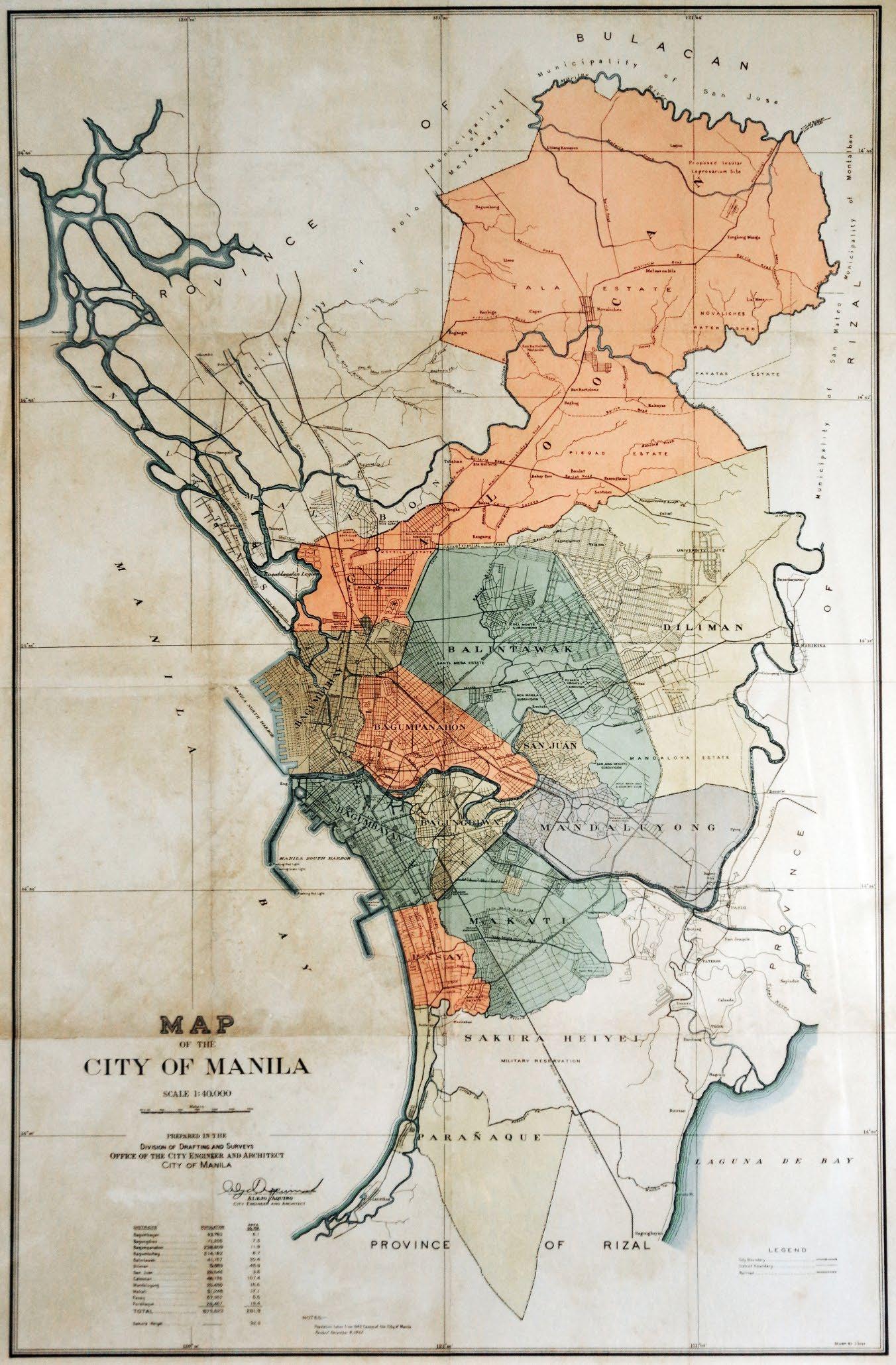
| International | |
|---|---|
| National | |
| Geographic | |
| Other | |
Quezon City
View on GrokipediaHistory
Origins and Establishment as Planned Capital (1935-1940)
The establishment of Quezon City originated from efforts by President Manuel L. Quezon to address Manila's overcrowding and inadequate infrastructure during the Philippine Commonwealth era, which began in 1935 following the Tydings-McDuffie Act granting limited self-governance in preparation for independence. Quezon, elected as the first Commonwealth president on November 15, 1935, envisioned a new capital city northeast of Manila to serve as the seat of government, incorporating planned residential, commercial, and administrative zones to accommodate population growth and government functions.[7][8] The selected site comprised approximately 15 square miles of largely agricultural land and estates, including portions from the municipalities of Caloocan, Marikina, Pasig, and San Juan del Monte, as well as the expansive Diliman and University estates owned by the government and private holders.[7] On September 28, 1939, the National Assembly approved Bill No. 1206, enacted as Commonwealth Act No. 502 and signed into law by Quezon on October 12, 1939, formally creating Quezon City as a planned municipality named in honor of the president.[7][8] The charter outlined the city's boundaries, governance structure—including an appointed mayor and council—and provisions for land acquisition to facilitate orderly development, with initial focus on acquiring over 10,000 hectares through expropriation and purchase to prevent speculative real estate practices.[7] This act marked Quezon City as the seventh city chartered under the Commonwealth, explicitly intended to replace Manila as the national capital upon full independence, reflecting Quezon's emphasis on social equity by prioritizing affordable housing for workers over elite developments.[9][10] Between 1939 and 1940, preliminary urban planning commenced under the National Planning Commission, laying out broad avenues and zones for government buildings, though detailed master plans like the later Frost-Arellano design were still in formative stages amid funding constraints and the approach of World War II. Initial infrastructure efforts included road extensions and site surveys to integrate the city with existing transport links to Manila, aiming for a self-sustaining urban center capable of housing up to one million residents.[9] The project's rationale was rooted in practical necessities—Manila's population density had exceeded 20,000 per square mile by the late 1930s—rather than symbolic relocation, prioritizing causal factors like housing shortages and sanitation issues over mere prestige.[7] By 1940, Quezon City remained largely undeveloped, with administrative functions temporarily housed in provisional structures, setting the stage for postwar realization of its capital ambitions.[8]World War II and Japanese Occupation (1941-1945)
The Japanese invasion of the Philippines commenced on December 8, 1941, with aerial attacks extending to military sites in Quezon City, including the bombing of Camp Murphy on December 10, which prompted Captain Jesús Villamor's heroic defense and subsequent award of the Distinguished Service Cross.[11] The swift Japanese advance forced United States Army Forces in the Far East (USAFFE) personnel to evacuate key installations, abandoning Philippine Commonwealth government buildings and other facilities in the city.[11] Under occupation from 1942 to 1945, Japanese authorities divided Quezon City into Balintawak and Diliman districts for administrative control, requisitioning public buildings as barracks and field hospitals while converting mansions into officers' residences and schools such as St. Paul’s College and St. Joseph’s College into medical facilities.[11] [12] Homes in Hacienda Magdalena and surrounding areas were seized to house garrisons, and Executive Order No. 400 temporarily dissolved the city's charter, merging it into Greater Manila; infrastructure changes included renaming roads, such as North Avenue to "Hilaga" and Quezon Boulevard Extension to "Mulawen."[11] [12] Civilians suffered acute shortages of food, water, and utilities, compounded by documented Japanese atrocities, including the 1942 execution of José Abad Santos, the mass killing of 52 Quezon Institute staff members, and instances of rape and murder during the invasion and 1945 retreat.[11] [12] Local guerrilla groups, including the Hunters ROTC and Blue Eagle Brigade, mounted resistance operations such as sabotage and ambushes, with figures like actor Mario Montenegro participating in the underground network; these efforts formed part of the nationwide Filipino resistance, which inflicted heavy casualties on Japanese forces but provoked reprisals contributing to 500,000–1,000,000 total military and civilian deaths across the Philippines.[11] [12] Allied liberation began in early 1945, with the Battle of Balintawak on February 2 marking a key engagement that facilitated U.S. forces' advance and the recapture of Quezon City by the end of February, ahead of Manila's liberation on March 3.[11] Bombing raids and occupation activities inflicted widespread destruction on civilian and military structures, though Quezon City avoided the scale of devastation seen in Manila due to the concentration of house-to-house fighting in the latter.[12]Postwar Reconstruction and Capital Consolidation (1946-1965)
Following the liberation of the Philippines in 1945, Quezon City faced extensive reconstruction needs after suffering damage from wartime bombings and occupation, with much of its nascent infrastructure, including planned residential and government sites, requiring rebuilding amid national resource shortages.[13] Efforts emphasized modernist architectural principles, employing concrete, steel, and simplified geometries to accelerate recovery and shift from prewar colonial styles, supported by U.S. aid under the Philippine Rehabilitation Act of 1946.[14] By 1947, initial housing initiatives relocated displaced Manila residents to Quezon City sites, utilizing machinery for mass production of affordable units in areas designated as "Projects" to address postwar urban overcrowding.[15] On July 17, 1948, President Elpidio Quirino signed Republic Act No. 333, designating Quezon City as the national capital to fulfill Manuel L. Quezon's prewar vision of a spacious, planned administrative center away from Manila's congestion, with the move effective immediately and formal inauguration occurring on October 12, 1949, via cornerstone-laying for key structures.[16] This shift prompted the Capital City Planning Commission to prioritize government relocations, including the University of the Philippines' transfer to Diliman campus in 1949, enhancing the city's role as an educational and administrative hub.[13] Boundary expansions solidified Quezon City's territorial consolidation; Republic Act No. 537, enacted June 16, 1950, revised the city charter to encompass 15,359 hectares—five times its original size—incorporating adjacent lands for future growth and infrastructure like the Elliptical Road (predecessor to parts of EDSA), initially designed as a two-way thoroughfare.[17] Under Mayor Ignacio Santos Diaz from 1954, dubbed "The Builder," developments accelerated with new roads, public markets, and the permanent Quezon City Hall, completed in phases through the 1950s, while population surged from approximately 108,000 in 1948 to over 400,000 by 1960, driven by rural-to-urban migration and housing incentives.[18] These measures entrenched Quezon City's status, with national agencies progressively transferring operations by the mid-1960s, though challenges persisted in matching infrastructure to rapid demographic pressures.[13]Marcos Administration Reforms and Expansions (1965-1986)
Following Ferdinand Marcos's inauguration as president on December 30, 1965, Quezon City retained its status as the national capital, facilitating ongoing administrative and infrastructural initiatives amid rapid urbanization. The declaration of martial law on September 21, 1972, via Proclamation No. 1081, centralized executive authority, enabling accelerated public works and urban reforms without legislative delays, though this period also saw heightened political repression in the city, including arrests at institutions like the University of the Philippines Diliman. Marcos's administration emphasized infrastructure to support population growth, with Quezon City's area remaining stable at approximately 166 square kilometers but its population rising from 397,375 in 1960 to 1,165,865 by 1980, driven by migration and informal settlements.[19] A key administrative reform occurred on November 7, 1975, when Marcos issued Presidential Decree No. 824, creating Metropolitan Manila (later Metro Manila) as an integrated administrative region encompassing Quezon City alongside Manila, Pasay, Caloocan, and portions of Rizal and Cavite provinces, aimed at coordinated planning for traffic, sanitation, and economic development across the congested urban core. This expansion of regional governance supplanted fragmented municipal systems, allowing for unified zoning and service delivery, though implementation faced challenges from overlapping jurisdictions and funding shortages. Subsequently, on June 24, 1976, Presidential Decree No. 940 relocated the official national capital back to Manila—its pre-1948 site—while designating the entire Metro Manila as the seat of government, effectively diminishing Quezon City's singular symbolic role but integrating it into a broader metropolitan framework that spurred inter-city infrastructure linkages like expanded circumferential roads.[20] Infrastructure expansions under Marcos prioritized specialized public facilities in Quezon City, reflecting a focus on monumental health edifices as part of the "New Society" program. The Philippine Heart Center, established on February 14, 1975, via Presidential Decree No. 673, was constructed in Quezon City's East Triangle district to deliver advanced cardiac care, equipped with diagnostic and surgical capabilities funded through government allocations and international loans. Similarly, the Lung Center of the Philippines, founded in 1981 under Presidential Decree No. 1823, addressed respiratory diseases with inpatient and research facilities in Quezon City, serving as a national referral hub amid rising urban pollution and smoking rates. These projects, totaling billions in construction costs, exemplified Marcos-era investments in vertical infrastructure but drew criticism for prioritizing prestige buildings over widespread poverty alleviation, with maintenance burdens contributing to later fiscal strains.[21]EDSA Revolution and Capital Relocation (1986-1990)
The People Power Revolution, occurring from February 22 to 25, 1986, saw significant participation from Quezon City residents along Epifanio de los Santos Avenue (EDSA) and adjacent areas, contributing to the nonviolent ouster of President Ferdinand Marcos. Crowds began assembling in Cubao, a major district within the city, on February 23, with approximately 10,000 people marching southward toward key military installations like Camp Aguinaldo, located in Quezon City, to shield reformist defense officials from loyalist forces. Barricades erected at intersections such as Tomas Morato and Timog Avenues in Quezon City withstood attempts by Marcos-aligned troops to advance, as civilians formed human chains and blockades that halted armored vehicles through sheer numbers, exemplifying the revolution's reliance on mass mobilization rather than armed conflict.[22] The success of the uprising, culminating in Marcos's flight to Hawaii on February 25, marked a pivotal shift in national governance under the newly installed President Corazon Aquino, but Quezon City's administrative status underwent limited immediate change. Mayor Adelina S. Rodriguez, appointed under Marcos and serving until April 13, 1986, was replaced by Brigido R. Simon Jr. on April 20, 1986, reflecting the broader purge of martial law-era officials amid Aquino's efforts to restore democratic institutions. Simon's tenure until 1992 focused on stabilizing local governance amid national uncertainties, including multiple coup attempts against Aquino between 1986 and 1990 that occasionally involved unrest in Metro Manila areas, though none fundamentally altered Quezon City's boundaries or highly urbanized status.[23] Despite the revolutionary fervor and Quezon City's historical role as the national capital from 1948 to 1976, no relocation of the capital back to the city occurred during 1986-1990; Presidential Decree No. 940, issued by Marcos in 1976, maintained Manila as the official capital while designating the entire National Capital Region (Metro Manila) as the seat of government functions, a framework upheld under Aquino without legislative reversal. This continuity prioritized administrative efficiency across the metropolitan area over restoring Quezon City's prior designation, even as the city hosted ongoing commemorations of the revolution, such as at sites along EDSA symbolizing people power. Discussions on capital status remained dormant until later decades, with no verifiable proposals or actions in this period to shift it from Manila.Post-EDSA Modernization and Urban Growth (1990-Present)
Following the EDSA Revolution and the subsequent relocation of the national capital to Manila in 1990, Quezon City transitioned into a primary commercial and residential hub within Metro Manila, experiencing accelerated urbanization driven by internal migration and economic opportunities. The city's population expanded from 1,666,766 in the 1990 census to 2,960,048 by 2020, reflecting a compound annual growth rate that outpaced national averages due to its proximity to employment centers and affordable housing relative to Manila.[24] [25] This growth intensified pressure on infrastructure but also spurred private-sector investments in mixed-use developments. A key driver of modernization was the emergence of business districts, particularly Eastwood City, launched in 1997 by Megaworld Corporation as the Philippines' first integrated "live-work-play" township spanning 18.5 hectares in Bagumbayan. Designed as an IT-BPM cyberpark, it attracted call centers and tech firms, contributing to Quezon City's shift toward a service-oriented economy; by the 2010s, the sector employed tens of thousands and positioned the city as a BPO powerhouse. Complementary developments included expansions in Cubao and Timog Avenue areas, where retail and entertainment complexes like the Araneta Center evolved into multi-modal transport nodes integrated with MRT Line 3, operational since 1999.[26] [27] Infrastructure enhancements post-1990 aligned with the 1991 Local Government Code's decentralization, enabling Quezon City to fund road widenings, flood control via the New Balara Aqueduct expansions, and the 2011-2025 Comprehensive Land Use Plan emphasizing sustainable density. However, rapid growth exacerbated traffic congestion along EDSA and Commonwealth Avenue, with average speeds dropping below 20 km/h in peak hours, and informal settlements persisted despite relocation efforts under the National Housing Authority. Economic output grew 4.4% in 2024, led by services (72% of GDP), underscoring resilience amid vulnerabilities like seismic risks in a densely built environment.[28] [29] [30] Urban planning initiatives focused on zoning for vertical growth, with high-rise condominiums proliferating in areas like South Triangle and Vertis North, developed post-2010 as part of the North Triangle master plan. Public-private partnerships facilitated projects like the Quezon City Central Business District, but implementation faced delays from land disputes and fiscal constraints, resulting in uneven development where wealthier enclaves contrasted with underserved barangays. By 2025, the city's GDP per capita lagged behind Makati but exceeded the national average, reflecting gains from agglomeration economies tempered by inequality and environmental strain.[30]Geography
Location, Topography, and Boundaries
Quezon City occupies the northeastern sector of Metro Manila in the National Capital Region, Philippines.[31] Its geographic extent spans latitudes from 14°35'15" N to 14°46'30" N and longitudes from 120°59'15" E to 121°07'30" E.[31] The city covers a land area of 16,112.58 hectares, equivalent to 161.13 square kilometers, making it the largest by area among Metro Manila's local government units.[31] The city's boundaries adjoin multiple neighboring jurisdictions: Caloocan City and San Jose del Monte City (Bulacan) to the north; San Mateo, Marikina City, and Rodriguez (Rizal) to the east; Pasig City, Mandaluyong City, San Juan City, and Manila to the south; and Valenzuela City, Caloocan City, Manila, Navotas City, and Malabon City to the west.[31] [32] These borders reflect historical territorial adjustments, including expansions and delineations under Republic Act No. 333 in 1948 and subsequent amendments.[3] Quezon City's topography features undulating terrain with slopes generally ranging from less than 8% to 15%, punctuated by small, scattered steeper areas often designated for parks or open spaces.[31] The predominant soil type is Novaliches Loam, a hard, compact adobe series suited to urban development but challenging for agriculture.[31] Elevations average 76 meters (250 feet) above sea level, with a key PAGASA meteorological station at 43 meters; low-lying zones near rivers remain prone to flooding, while northern uplands host the La Mesa Watershed at higher contours.[31] [33] The eastern margin aligns with the West Valley Fault System, contributing to seismic risk, alongside river basins like Tullahan and Marikina that shape drainage and define topographic depressions.[31]Climate Patterns and Environmental Risks
Quezon City features a tropical monsoon climate, with consistently high temperatures and pronounced wet and dry seasons influenced by the Intertropical Convergence Zone and monsoons. Data from the PAGASA Science Garden station (1991-2020 normals) indicate an annual mean temperature of 27.8°C, with average maximums of 32.1°C and minimums of 23.6°C. The hottest period occurs from March to May, peaking in April at a mean of 29.4°C and maximum of 34.6°C, while the coolest months are December to February, with means around 26-27°C. For example, on February 1, 2026, under the Northeast Monsoon, temperatures at the Science Garden station ranged from 20.7°C (minimum) to 30.9°C (maximum), with partly cloudy to cloudy skies and isolated light rains possible (around 10% chance), while a shear line brought scattered rains and thunderstorms to eastern sections of Southern Luzon and Visayas.[34] High humidity persists year-round, often exceeding 80%, fostering muggy conditions conducive to thunderstorms, which number about 106 days annually.[35] Precipitation totals 2,785.6 mm annually across 143 rainy days, concentrated in the wet season from June to November due to the southwest monsoon (habagat). August records the highest monthly rainfall at 568.5 mm over 21 days, followed by July (516.6 mm) and September (500.3 mm), while the dry season (December-May) sees minimal rain, with January at 27.1 mm. This pattern aligns with the Philippines' exposure to approximately 20 typhoons per year, many tracking through Luzon during the wet season, amplifying rainfall events.[35][36] Flooding constitutes the primary environmental risk, affecting 78 areas across 35 barangays due to five river systems (San Juan, Tullahan, Marikina, Pasig, Meycauayan) and 44 tributaries, despite the city's average elevation of 43 meters exceeding that of Manila. Urban expansion has worsened vulnerability through reduced permeability and clogged drainage, leading to regular inundation; Typhoon Ondoy (Ketsana) in September 2009 displaced thousands and caused 83 local fatalities amid 6,485 affected families. Seismic hazards arise from the West Valley Fault, which bisects eastern Quezon City and could rupture in a magnitude 7.2 event, projecting up to 3,000 deaths, 9,000 injuries, and extensive building collapses.[36][37][36] Landslides threaten hilly districts like Commonwealth, Batasan Hills, and Payatas, frequently triggered by prolonged heavy rains, as in the 2012 Habagat event that killed nine. Climate variability, including El Niño-induced droughts and La Niña-enhanced wet spells, compounds these risks, with projections of intensified typhoon rainfall and heatwaves under ongoing warming trends. In response, Quezon City declared a climate emergency in 2019 to prioritize adaptation measures amid these persistent threats.[36][38][39]Land Use and Green Spaces
Quezon City's total land area measures 16,112.58 hectares, with actual land use dominated by residential development encompassing 5,094.09 hectares, or 31.62 percent of the total. Commercial zones occupy 1,220.01 hectares (7.6 percent), industrial areas 328.56 hectares (2.04 percent), and institutional uses 1,547.26 hectares. Parks and designated open spaces cover 166.67 hectares, reflecting limited formal recreational allocation amid rapid urbanization. Informal settlements encroach on 788.59 hectares of residential land, complicating land management.[31]| Land Use Category | Area (hectares) | Percentage |
|---|---|---|
| Residential | 5,094.09 | 31.62 |
| Commercial | 1,220.01 | 7.6 |
| Industrial | 328.56 | 2.04 |
| Institutional | 1,547.26 | 9.6 |
| Parks/Open Spaces | 166.67 | 1.03 |
Administrative Divisions
Barangays and Zoning
Quezon City is subdivided into 142 barangays, the fundamental administrative units under the Philippine local government system, each governed by an elected barangay council headed by a captain.[42] These barangays handle grassroots services such as public safety, health, and community development, with boundaries often aligned to historical villages or neighborhoods.[43] For congressional representation, the barangays are allocated across six legislative districts: District 1 encompasses 37 barangays in the northern and eastern areas; District 2 covers 5 barangays in the central zone; District 3 includes 37 in the west; District 4 has 38 in the southwest; District 5 comprises 14 in the south; and District 6 contains 11 in the southeast.[43] All barangays are designated as urban, reflecting the city's dense built-up character.[25] Land use and zoning in Quezon City are governed by the Comprehensive Zoning Ordinance of 2016, which divides the territory into specific districts to control development intensity, compatible uses, and infrastructure demands.[44] This ordinance implements the broader Comprehensive Land Use Plan (2011-2025), emphasizing balanced urban growth, environmental protection, and residential-commercial integration while restricting incompatible activities like heavy industry near housing.[28] Key zoning categories include:| Zone Category | Subtypes | Primary Purpose and Allowable Uses |
|---|---|---|
| Residential | R-1 (low density, up to 20 du/ha), R-1-A, R-2 (medium, up to 60 du/ha), R-2-A, R-3 (high density, 101+ du/ha) | Single- and multi-family dwellings, community facilities; height limits from 10m (3 storeys) to varying based on flood risk.[44] |
| Commercial | C-1 (minor), C-2 (major), C-3 (metropolitan) | Retail, offices, entertainment; scales from district-level services to regional malls, with floor area ratios up to 6 in C-2 areas.[44] |
| Industrial | I-1 (light, non-pollutive), I-2 (general, pollutive/hazardous) | Manufacturing and processing; stricter height (9m near residences) and separation from residential zones.[44] |
| Institutional (INST) | N/A | Government, educational, religious, and medical facilities like schools and hospitals.[44] |
| Parks and Recreation (PR) | N/A | Open spaces, parks for recreation and ecological balance.[44] |
| Other Special Zones | SUDZ (e.g., Tomas Morato), SHZ (socialized housing), EPA (environmental protection), TRU (transport/utilities), CEM (cemeteries) | Tailored controls for urban development, affordable housing per RA 7279, biodiversity preservation, infrastructure, and burial sites.[44] |
Congressional and Electoral Districts
Quezon City is represented in the House of Representatives of the Philippines by six congressional districts, each electing one representative for a three-year term.[45] The current district configuration resulted from the reapportionment under Republic Act No. 10170, enacted on July 2, 2012, which divided the existing second legislative district into three separate districts, thereby increasing the total from four to six.[45][46] This adjustment aimed to better reflect population growth and ensure equitable representation, as the second district had become the most populous in the country prior to the change.[47] The six districts collectively cover all 142 barangays of Quezon City, with boundaries delineated to group contiguous areas based on geographic and demographic considerations. District 1 encompasses northwestern areas including Barangays Bagong Pag-asa and Project 6; District 2 covers eastern sections bordering Marikina such as Barangay Greater Fairview; District 3 includes central and southern parts like Barangay Commonwealth; District 4 spans southeastern zones including Barangay Payatas; District 5 comprises parts of the southwest such as Barangay Tandang Sora; and District 6 includes upscale northern areas like Barangay White Plains.[48] Elections for congressional representatives occur concurrently with national polls, with the most recent held on May 9, 2022. For local governance, the electoral districts for the Sangguniang Panlungsod (city council) are coextensive with the congressional districts, enabling voters in each to elect six councilors per district, totaling 36 members.[45] The 2012 reapportionment also created 12 additional council seats to match the new districts, enhancing local legislative capacity.[49] City council elections align with midterm national elections, ensuring synchronized representation at both levels.[50] This structure promotes district-specific advocacy on issues like infrastructure and services while maintaining citywide coordination.Urban Planning and Cityscape
Original and Evolved Master Plans
The original master plan for Quezon City, formulated in 1940 by American planner Harry T. Frost with contributions from Filipino architect Juan Arellano and others including Alpheus D. Williams and Welton Becket, was approved by the Philippine government in June 1941.[3][9] This Frost-Arellano Plan envisioned a "Garden City" model inspired by Ebenezer Howard's concepts, featuring radial avenues, extensive greenbelts, parks occupying at least 20% of land area, and a central Diliman Quadrangle for government buildings to serve as the new national capital.[51] The layout prioritized low-density residential zones, waterways with wide easements for flood control, and decentralized commercial nodes to decongest Manila, with an initial projected population of around 400,000.[9][52] Implementation stalled during World War II, with Japanese occupation and subsequent destruction limiting adherence to the plan; postwar reconstruction in the late 1940s introduced a revised 1949 master plan that retained the garden city emphasis on open spaces but incorporated immediate housing and infrastructure needs amid rapid influxes of residents.[51] By the 1950s, deviations emerged due to informal settlements, agricultural land conversions, and political decisions like boundary expansions, eroding green space allocations—original plans allocated over 1,000 hectares for parks, but actual development prioritized urban sprawl, reducing per capita open space to under 2 square meters by the 2000s.[9][51] Subsequent evolution shifted toward statutory comprehensive frameworks mandated by Republic Act 7160 (Local Government Code of 1991), culminating in the 2011-2025 Comprehensive Land Use Plan (CLUP), which rezoned approximately 15,300 hectares into mixed-use districts, institutional zones, and protected areas to balance residential density (projected at 20,000 persons per square kilometer in core areas) with environmental safeguards like riparian buffers.[53] This CLUP, developed through stakeholder consultations, addressed shortcomings of earlier plans by integrating geographic information systems for land use mapping and enforcing height restrictions in low-rise zones to mitigate skyline inconsistencies from unchecked high-rise growth.[28] The 2021-2025 Comprehensive Development Plan further refined these efforts under the national Rationalized Planning System, emphasizing sectoral integration for resilience against flooding and seismic risks, with targets to expand green corridors to 25% of land area and upgrade infrastructure like the P27-billion drainage masterplan to restore original waterway functions.[54][55][56] Despite these updates, challenges persist from population pressures exceeding 2.9 million residents as of 2020, often overriding planned low-density ideals with high-density commercial hubs, underscoring a tension between visionary blueprints and pragmatic urban adaptation.[54]Architectural Features and Landmarks
Quezon City's architecture reflects its origins as a planned capital city established in the mid-20th century, incorporating modernist, Art Deco, and Brutalist elements alongside contemporary developments. Public buildings emphasize symmetry, concrete structures, and symbolic grandeur, influenced by post-war reconstruction and nationalistic aspirations.[57][58] The Quezon Memorial Shrine, located in Quezon Memorial Circle, stands as the city's central landmark, designed by architect Federico S. Ilustre and constructed from 1952 to 1978. This 66-meter-tall structure features three pylons clad in white Carrara marble from Italy, topped by bronze angels symbolizing faith, hope, and charity, with Manuel L. Quezon's remains interred in the base. Originally intended as the site for the National Capitol, the shrine's Art Deco-inspired design serves as a mausoleum and museum dedicated to the former Philippine president.[59][60][61] Quezon City Hall, a 14-story modernist edifice inaugurated in 1974, exemplifies the city's administrative architecture with its symmetrical facade and illusion of weightlessness achieved through clean lines and elevated structure. Designed by architect Ruperto Gaite and located along Elliptical Road in Diliman, the building includes a prominent adobe relief on its facade depicting the life of President Manuel L. Quezon, sculpted by Eugenio R. Bunuan.[62][58][63] The Smart Araneta Coliseum, known as the "Big Dome," represents Quezon City's entertainment infrastructure, built from 1957 to 1959 with a distinctive dome design by architect Rufino D. Antonio Sr. This multi-purpose arena in Cubao spans 3.6 hectares and features exceptional acoustics due to its concrete dome, hosting sports, concerts, and events since its 1960 inauguration.[64][65][66] Quezon Hall at the University of the Philippines Diliman campus embodies neoclassical-modern synthesis, designed by National Artist for Architecture Juan F. Nakpil and constructed in the early 1950s. Positioned as the administration building behind the Oblation statue, it features four massive columns supporting an archway, blending classical proportions with modernist simplicity to serve as the university's gateway structure.[67][68][69]Development Achievements and Shortcomings
Quezon City has registered robust economic expansion, posting a gross domestic product of ₱1.27 trillion in 2023, positioning it as the top contributor to the Philippine economy among highly urbanized cities and accounting for 19.3% of the National Capital Region's output.[70][71] This growth stems from concentrated business districts such as Eastwood City, Cubao, and the Quezon Avenue corridor, where small- and medium-sized enterprises dominate wholesale and retail trade, services, and manufacturing, fostering job creation and attracting investments.[5][30] Infrastructure enhancements, including road expansions, bridge constructions, and drainage system upgrades under the 2021-2025 Comprehensive Development Plan, have supported this trajectory by improving internal mobility and flood mitigation in key areas.[55][72] The city's urban planning has advanced toward smart city status through data-driven governance and initiatives like the Economic Development and Investment Plan 2022-2025, projecting a 4.6% annual growth rate—the highest among urban centers—by leveraging its educational institutions and innovation hubs for sustainable development.[73][74] Fiscal policies emphasizing transparency and inclusive leadership have elevated Quezon City to the status of the nation's richest local government unit, enabling investments in digitalization, climate resilience, and public services that underpin long-term competitiveness.[75] However, implementation of original master plans, such as the 1941 Frost-Arellano blueprint, has yielded mixed results, with successes in zoning for mixed-use developments overshadowed by ad-hoc expansions that strain resources.[76] Persistent shortcomings arise from unchecked population pressures, with over 3 million residents exacerbating traffic congestion, informal settlements, and urban poverty affecting vulnerable households.[77][38] Flooding remains a critical vulnerability, particularly in low-lying barangays during typhoons, where inadequate drainage and encroachment on waterways amplify risks despite ongoing upgrades, as evidenced by recurrent evacuations and property damage.[78][79] These issues reflect broader failures in enforcing land-use regulations amid rapid informal urbanization, contributing to environmental degradation and socioeconomic disparities that hinder equitable progress.[80][81]Demographics
Population Dynamics and Density
The population of Quezon City, as enumerated in the 2020 Census of Population and Housing conducted by the Philippine Statistics Authority (PSA), stood at 2,960,048 residents.[82] This figure reflects an increase of 23,932 from the 2015 census count of 2,936,116, equating to an annual growth rate of approximately 0.16 percent over the intervening five years.[82] However, Quezon City officials, including then-Mayor Joy Belmonte, contested the 2020 results as an undercount, citing local vital statistics records of roughly 300,000 births and 100,000 deaths between 2015 and 2020, which alone implied a natural increase exceeding the reported total growth; they further argued that net in-migration would have driven a minimum 6.8 percent rise, prompting calls for a PSA audit.[82] [83] Local lawmakers echoed this, seeking congressional probes into potential irregularities in enumeration processes.[84] Historical census data illustrate a pattern of robust expansion through the late 20th century, fueled by rural-to-urban migration amid Metro Manila's industrialization, the presence of major universities like the University of the Philippines Diliman, and expanding employment in services and government.[24] From 1990 to 2010, the population more than doubled, but growth decelerated sharply post-2010, potentially reflecting maturing urbanization, out-migration to peripheral areas, and data collection challenges rather than demographic stagnation.[80]| Census Year | Population | Annual Growth Rate (from prior census) |
|---|---|---|
| 1990 | 1,669,776 | - |
| 2000 | 2,173,831 | 2.68% |
| 2010 | 2,761,720 | 2.42% |
| 2015 | 2,936,116 | 1.23% |
| 2020 | 2,960,048 | 0.16% |
Ethnic, Linguistic, and Religious Profile
Quezon City's ethnic profile is characterized by a Tagalog majority, augmented by migrants from other Philippine regions, reflecting patterns of internal migration to the National Capital Region. According to the 2015 Census of Population and Housing conducted by the Philippine Statistics Authority (PSA), the household population of 2,751,579 identified as follows: Tagalog at 46.78% (1,287,154 individuals), Bisaya/Binisaya at 13.47% (370,580), Bicolano at 9.03% (248,588), Ilocano at 8.13% (223,692), and other groups comprising the remaining 10.23% (281,399).[87] These figures underscore Quezon City's role as a migration hub, drawing from Visayas and Bicol regions for economic opportunities, though Tagalog ethnicity dominates due to the city's location in the historically Tagalog-speaking area of Luzon.[87]| Ethnic Group | Percentage | Number (2015) |
|---|---|---|
| Tagalog | 46.78% | 1,287,154 |
| Bisaya/Binisaya | 13.47% | 370,580 |
| Bicolano | 9.03% | 248,588 |
| Ilocano | 8.13% | 223,692 |
| Others | 10.23% | 281,399 |
| Total | 100% | 2,751,579 |
Socioeconomic Conditions and Inequality
Quezon City exhibits socioeconomic conditions marked by low poverty incidence and elevated average family incomes relative to national benchmarks, reflecting its status as a key urban hub in the National Capital Region (NCR). The poverty incidence among families in Quezon City was 1.8% in 2021, substantially lower than the national rate of 18.1% during the same period.[88] This figure aligns with broader NCR trends, where poverty incidence among families fell to 1.1% in 2023, underscoring the region's relative prosperity amid national challenges.[89] Average annual family income in the NCR reached PHP 513,520 in 2023, more than 45% above the national average of PHP 353,230, driven by concentrations of service-sector employment, business process outsourcing, and proximity to educational and commercial centers.[89][90] Despite these indicators of overall advancement, income inequality remains pronounced, as evidenced by Quezon City's Gini coefficient of 0.4267 in 2018—elevated compared to the national Gini of approximately 0.41 in recent years and indicative of uneven wealth distribution within its highly urbanized landscape.[40][91] This disparity manifests spatially, with affluent commercial districts such as Eastwood City and Tomas Morato contrasting sharply against informal settlements and low-income barangays like Payatas, where historical reliance on waste scavenging and limited access to formal employment perpetuate pockets of vulnerability. Household sizes average 4.3 members, amplifying pressures on lower-income families amid rising living costs in a dense metropolitan setting.[30] Efforts to address inequality include local government initiatives targeting urban poor communities, though structural factors like informal labor markets and rapid urbanization sustain gaps; for instance, while NCR-wide poverty thresholds are met by most, barangay-level variations highlight the need for targeted interventions to mitigate risks from economic shocks.[30] Data from the Philippine Statistics Authority, derived from Family Income and Expenditure Surveys, provide the empirical basis for these assessments, offering reliable measures despite challenges in capturing informal economies fully.[88]Economy
Core Sectors and Business Hubs
Quezon City's economy is dominated by the services sector, with professional, scientific, and technical services accounting for 36.18% of employment.[92] Administrative and support service activities, including business process outsourcing (BPO), represent the largest employment category at 219,891 workers or 31.04% as of 2018 data.[30] Wholesale and retail trade follows closely, while real estate, renting, and other business activities form a major segment, particularly in leasing properties.[5] The city's gross regional domestic product reached ₱1.27 trillion in 2023, positioning it as the largest contributor to the Philippine economy and 19.3% of the National Capital Region's output, driven by these service-oriented industries.[70][93] Key business hubs in Quezon City include Eastwood City in Libis, a mixed-use development serving as a cyberpark for BPO firms and featuring retail, residential, and entertainment facilities.[94] UP-Ayala Land TechnoHub, adjacent to the University of the Philippines Diliman, concentrates on information technology, innovation, and knowledge-based enterprises, attracting tech startups and multinational corporations.[94] Araneta City in Cubao functions as a transportation nexus with integrated commercial spaces, retail malls like Araneta Center, and entertainment venues including the Smart Araneta Coliseum.[94] Triangle Park, designated as the Quezon City Central Business District, spans 250 hectares and supports corporate offices, government institutions, and emerging high-rise developments with connectivity to major thoroughfares.[95] Vertis North in Quezon Avenue emerges as another integrated hub blending office spaces, residential towers, and shopping areas.[94] These districts collectively foster economic activity through incentives like tax holidays for IT-BPM locators and infrastructure improvements.[96]Labor Market and Competitiveness
Quezon City's labor market is dominated by the services sector, which accounts for the majority of employment, including business process outsourcing (BPO), wholesale and retail trade, and administrative support services. Wholesale and retail trade holds the largest share at 24.4% of employed persons, followed by manufacturing at 10.4% and construction at 9.1%.[5][92] The BPO industry, a key driver, employs a significant portion of the workforce, with the city hosting 135 establishments and serving as the National Capital Region's primary ICT hub; as of November 2021, PEZA-registered economic zones in Quezon City supported 202,725 jobs, many in IT-BPM roles.[97][98] National labor trends, which the city mirrors due to its urban integration, show services comprising 61.4% of jobs, with employment growth concentrated in high-skill areas like call centers and digital services from firms such as Concentrix and TaskUs.[99][100] Unemployment in Quezon City aligns with national figures, which hit a record low of 4.3% in 2023 amid rising labor force participation to 64.9%, though underemployment persists in informal and low-wage segments.[101] The city's workforce benefits from proximity to educational institutions like the University of the Philippines Diliman, fostering a supply of English-proficient, tech-savvy graduates suited for BPO and knowledge-based jobs; BPO employment in the Philippines exceeded 1.5 million by 2023, with Quezon City contributing disproportionately due to its locational advantages.[102][103] Wage and salaried employment predominates, with over 80% of workers in formal roles as of earlier surveys, though small enterprises still underpin much of the retail and trade base.[30] Quezon City's competitiveness bolsters its labor market appeal, earning it the top ranking as the most competitive highly urbanized city in the 2024 Cities and Municipalities Competitiveness Index (CMCI) for the fourth year running, with first place in infrastructure and strong showings in economic dynamism and resiliency.[104][105] The Philippine Chamber of Commerce and Industry named it the most business-friendly local government in 2023, citing efficient permitting and investment incentives that attract BPO and tech firms, thereby enhancing job quality over low-skill alternatives.[106] These factors contribute to a business environment that outperforms peers, though national ease-of-doing-business challenges, such as permitting delays, persist despite local reforms.[107][108]Fiscal Policies and Growth Drivers
Quezon City's fiscal framework relies on a mix of local tax revenues, including real property taxes and local business taxes, supplemented by non-tax sources such as fees and economic enterprise receipts, alongside external national tax allocations. The 2024 annual budget details these components, with total local sources forming the bulk of funding for development initiatives.[109] In line with broader local government unit practices, business taxes constitute a significant portion of collections, incentivizing efficient administration to support self-reliance.[110] To bolster investment, the city enacted Ordinance SP-3290 in September 2024, modernizing incentives for medium and large enterprises with assets over PHP 15 million. Qualifying new branches or expansions receive a two-year exemption from business tax, amusement tax, and other local impositions, while relocating principal offices gain a 10-year graduated situs tax reduction, starting at full exemption and tapering to standard rates.[111][112] Businesses aligned with the city's Investment Priority Plan, targeting sectors like information technology and logistics, qualify for up to three years of tax holidays.[113] Long-standing enterprises also benefit from a 10% situs tax discount for sustained operations.[114] These measures drive economic expansion by lowering entry barriers and retaining capital, evidenced by Quezon City's 4.4% GDP growth in 2024, following a trillion-peso milestone in 2023.[115][116] The Economic Development and Investment Plan (2022-2025) integrates these policies to prioritize high-value sectors, attracting foreign and domestic capital through streamlined permitting and fiscal relief, which has positioned the city as a top performer in business-friendliness, earning Hall of Fame status from the Philippine Chamber of Commerce and Industry in 2025.[73][117] Such incentives correlate with increased local revenue effort, rewarding fiscal prudence amid Metro Manila's competitive landscape.[118]Government and Politics
Local Governance Structure
Quezon City functions as a highly urbanized independent component city within Metro Manila, governed by a mayor-council system established under the Local Government Code of 1991 (Republic Act No. 7160).[119] The executive authority resides with the elected city mayor, who oversees the implementation of policies, ordinances, and programs, supported by various departments and offices including the Office of the City Administrator for advisory and strategic functions.[120] The mayor's term is three years, with a maximum of three consecutive terms.[119] The legislative body, known as the Sangguniang Panlungsod or Quezon City Council, is headed by the vice mayor as presiding officer and consists of 36 elected councilors divided equally among six districts coextensive with the city's congressional districts.[121] These councilors enact ordinances, approve budgets, and oversee city development, with districts varying in size: the first district includes 37 barangays, the second five, the third 37, the fourth 38, the fifth 14, and the sixth 11.[122] At the grassroots level, Quezon City is divided into 142 barangays, each administered by a barangay captain elected for a three-year term, alongside a seven-member barangay council responsible for local ordinances, community services, and dispute resolution within their jurisdiction.[123] Barangays also feature youth councils (Sangguniang Kabataan) for residents aged 15-30, promoting youth participation in governance.[119] This tiered structure ensures decentralized administration, with higher levels providing oversight and resource allocation to barangays.[121]Elected Leadership and Administration
Quezon City's elected leadership operates under the framework of the Philippines' Local Government Code of 1991, which establishes a strong mayor-council system. The executive branch is headed by the mayor, who serves as the chief executive responsible for implementing ordinances, managing city services, preparing the budget, and appointing department heads subject to council confirmation. The mayor's term is three years, with a limit of three consecutive terms. As of October 2025, the mayor is Ma. Josefina G. Belmonte, re-elected on May 12, 2025, for her third and final consecutive term with over 1 million votes, proclaimed on May 13, 2025.[124] Previously serving from 2019, Belmonte's administration oversees key executive functions through departments such as social welfare, health, engineering, and public safety.[125] The vice mayor, who presides over the legislative body and assumes mayoral duties in the mayor's absence, is Gian Carlo G. Sotto, re-elected in the 2025 polls and proclaimed alongside Belmonte.[124] Sotto, in office since 2019, chairs the Sangguniang Panlungsod sessions and influences legislative priorities.[126] The Sangguniang Panlungsod, or city council, consists of 36 elected councilors—six from each of the city's six legislative districts—plus ex-officio members including the president of the Association of Barangay Captains and the Sangguniang Kabataan federation president. Councilors enact ordinances, approve budgets, and oversee executive performance, with elections held every three years. The 2025 elections filled these positions, maintaining continuity in the Belmonte-Sotto tandem's coalition dominance.[121] Local elections occur simultaneously with national midterms, ensuring alignment with broader political cycles.[127]National Political Influence and Controversies
Quezon City wields substantial national political influence as the Philippines' most populous city, boasting over 1.4 million registered voters in 2025 and serving as Metro Manila's premier vote-rich jurisdiction.[128] This electoral heft, combined with its six congressional districts, enables the city to dispatch a significant bloc to the House of Representatives, often tipping balances in national legislation.[127] In the 2025 local elections, Mayor Joy Belmonte garnered over 1 million votes for her third term, reinforcing her stature as National Chairperson of the League of Cities of the Philippines and amplifying Quezon City's voice in federal policy discussions.[129][130] The prevalence of political dynasties underscores the city's entrenched role in national power dynamics, with at least 16 families controlling key positions in the National Capital Region as of 2013, a figure that sustains familial dominance across local and congressional races.[131] These dynasties, exemplified by the Belmonte and Sotto clans, facilitate the aggregation of votes and resources that extend to senatorial and presidential campaigns, though they draw criticism from younger demographics seeking to dismantle such concentrations of power.[132] Quezon City's foundational intent as the postcolonial capital, established in 1939 under President Manuel L. Quezon, imbued it with symbolic and administrative precedence until Manila reclaimed the status in 1976, a legacy that continues to draw national institutions and media outlets headquartered there.[9] Hosting the University of the Philippines Diliman, the city remains a nexus for activism, as evidenced by the September 2025 protests involving over 3,000 students decrying corruption in national flood control projects.[133] Controversies have periodically tarnished this influence, including the October 2025 Supreme Court affirmation of a graft conviction against former District III Councilor Dante Manzano De Guzman for PHP 6 million in ghost projects, highlighting misuse of public funds.[134] Similarly, the city terminated four infrastructure contracts with Discaya-affiliated firms in October 2025 following license revocations, amid broader scrutiny of procurement irregularities.[135] The September 2025 resignation of Congressman Arjo Atayde ignited allegations of fund misappropriation totaling millions, while a former Quezon City congressman disclosed details of infrastructure corruption to the Ombudsman that month, fueling national debates on accountability.[136][137] These incidents reflect systemic challenges in governance, often exacerbated by dynastic entrenchment and opaque project bidding.Infrastructure
Transportation Systems
Quezon City's transportation infrastructure centers on an extensive road network integrated with Metro Manila's rail and bus systems, serving a population exceeding 2.9 million residents as of the 2020 census. Major arterial roads include Epifanio de los Santos Avenue (EDSA), a 23.8-kilometer expressway traversing the city's eastern boundary, connecting it to Manila, Makati, and Pasay, though it experiences chronic congestion due to high vehicle volumes exceeding 400,000 daily trips in peak hours. Commonwealth Avenue and Quirino Highway serve as primary north-south corridors, handling significant intra-city and inter-regional traffic.[138] Public rail transport relies on the MRT-3 line along EDSA, with stations such as Quezon Avenue, Kamuning, and North Avenue providing access to central business districts like Ortigas and Makati; the line carries over 500,000 passengers daily across Metro Manila. LRT-2's Santolan station links eastern Quezon City to Manila's financial core, while jeepneys—color-coded route-based minibuses—dominate short-haul travel, supplemented by UV Express vans and tricycles for last-mile connectivity in barangays. Conventional buses operate on provincial routes via terminals like Cubao, with operators including Victory Liner and Jam Liner serving northern Luzon destinations.[139][140][141] The city's Traffic and Transport Management Department (TTMD) oversees policies to mitigate gridlock, including the proposed España-Quezon Avenue busway modeled on the EDSA Bus Rapid Transit (BRT) system, which prioritizes dedicated bus lanes along EDSA to reduce travel times by up to 30%. In 2024, Quezon City introduced electric buses for free public rides, expanding an eco-friendly fleet amid efforts to phase out aging jeepneys under national modernization programs. Airport access to Ninoy Aquino International Airport involves MRT or bus transfers via EDSA, taking 1-2 hours depending on traffic, while shuttles connect to Clark International Airport.[142][143][144] Active transport initiatives have grown, with approximately 200 kilometers of bike lanes established by January 2024, supporting over 16,000 daily cyclists and targeting expansion to 350 kilometers; protected lanes use barriers like plant boxes for safety. Pedestrian enhancements include the 5.39-kilometer GORA Lane corridor, featuring raised crossings and narrowed vehicle lanes to promote walking in high-density areas. These measures address congestion's root causes, such as EDSA's conversion from highway to mixed-use avenue, which has amplified bottlenecks without corresponding capacity upgrades.[145][146][147][148]Utilities and Public Services
Electricity distribution in Quezon City is handled by the Manila Electric Company (Meralco), the primary utility serving Metro Manila, including partnerships for initiatives like solar energy adoption established in August 2025.[149] Meralco maintains infrastructure such as power lines and supports applications for new connections through online portals and hotlines.[150] Water supply and sewerage services are divided between Maynilad Water Services, Inc., covering western areas including parts of Quezon City from its base in the MWSS Complex, and Manila Water Company, Inc., serving eastern zones with treatment facilities in Balara.[151][152] Both providers ensure compliance with Philippine National Standards for Drinking Water, with Maynilad handling distribution via pipelines to meet daily demands.[153] The Department of Sanitation and Cleanup Works (DSQC) oversees waste management and sanitation, providing daily collection services to all 142 barangays via private contractors organized by six city regions, with segregated schedules for biodegradable and non-biodegradable materials.[154][155] Programs like "Trash to Cashback," launched to reduce plastic waste, enable residents to trade recyclables for food and groceries at designated exchange points.[156] Public safety falls under the Quezon City Police District (QCPD), with 15 stations addressing local law enforcement, and the Quezon City Fire District (QCFD), operating from the city hall compound for emergency response via hotline 8330-2344.[157][158]Healthcare
Medical Facilities and Access
Quezon City features a combination of public and private medical facilities, with government-owned hospitals including the Quezon City General Hospital, a 250-bed tertiary-level institution serving primarily low-income residents; the Philippine Heart Center, focused on cardiovascular care; the Philippine Orthopedic Center, specializing in musculoskeletal treatments; East Avenue Medical Center, handling general and trauma cases; and Quirino Memorial Medical Center.[159] [160] Private providers encompass St. Luke's Medical Center Quezon City, Capitol Medical Center, and World Citi Medical Center, offering advanced diagnostics and specialized services. The city counts roughly 35 private hospitals alongside 9 national government facilities, though these are concentrated in only 22 of its 142 barangays, creating geographic disparities in proximity.[161] [162] [163] [164] [165] The Quezon City Health Department (QCHD) coordinates public access through primary care at barangay health centers, immunization programs, and maternal-child health services, supported by the national Universal Health Care framework for broader PhilHealth coverage. Specialized national institutes like the Philippine Heart Center admit patients based on referrals and capacity, prioritizing public needs.[166] [167] [168] Challenges persist due to the Philippines' overall low hospital bed density of 0.5 per 1,000 population, with Quezon City facilities experiencing full occupancy during COVID-19 surges, such as in August 2021 when two hospitals reported zero available COVID-19 beds. Urban density amplifies demand, prompting local initiatives for infrastructure expansion and integrated reporting systems, though primary care gaps remain in underserved areas.[169] [170][171]Public Health Outcomes and Challenges
Quezon City experiences elevated mortality rates influenced by its dense urban population of over 2.9 million, with 31,931 registered deaths in 2021, marking a 29.5% increase from 2020, primarily driven by COVID-19 as a top cause alongside ischemic heart diseases and neoplasms.[172] [173] By 2022, acute myocardial infarction emerged as a leading cause among 17,253 deaths, reflecting persistent non-communicable disease burdens exacerbated by lifestyle factors and limited preventive care access in informal settlements.[174] Infant mortality data from 2018 indicated 1,007 cases, with males comprising 54.22% , though recent city-specific rates align closely with the national average of 22.1 per 1,000 live births in 2023, underscoring gaps in neonatal care amid high birth volumes.[87] [175] Infectious disease outcomes show mixed progress; the city reported over 277,000 COVID-19 cases by May 2023, the highest in the Philippines, yet local governance enhancements post-pandemic, including expanded vaccination drives, contributed to declining hospitalization rates despite initial high incidence.[176] [177] Dengue incidence fluctuated above epidemic thresholds in early 2025, with spatial hotspots persisting from 2019-2022 due to urban water stagnation.[178] HIV diagnoses rose 2.43% to 421 cases from January to May 2025, signaling challenges in targeted screening amid national surges.[179] Key challenges stem from environmental and structural factors: severe air pollution from traffic congestion elevates respiratory illnesses, with particulate concentrations in high-density areas averaging hazardous levels and contributing to cardiovascular deaths, which nationally account for 19% of fatalities.[180] [181] Frequent flooding from typhoons and clogged drains has driven leptospirosis cases past 100 in 2025, with District 2 recording 9 deaths, as urban poor communities face delayed medical evacuation and poor sanitation.[182] Climate-intensified risks, including heatwaves and informal settlements, compound non-communicable diseases like diabetes and hypertension, prevalent among elderly residents and linked to 60% of national lifestyle-related deaths.[183] [167] [184] Despite investments like PHP 239 million in 2024 for universal health coverage, systemic issues such as overburdened facilities and vaccine hesitancy—cited by 58.5% of unvaccinated pediatric caregivers due to safety concerns—hinder equitable outcomes.[185] [186]Education
Primary and Secondary Systems
Quezon City's primary and secondary education systems operate under the national K-12 framework administered by the Department of Education (DepEd) through the Schools Division Office of Quezon City (SDO-QC), which oversees public institutions emphasizing foundational literacy, numeracy, and skills development. Public elementary education covers Grades 1-6, focusing on core subjects like mathematics, science, and language, while secondary education spans Grades 7-10 for junior high school (JHS) and Grades 11-12 for senior high school (SHS), incorporating specialized tracks such as academic, technical-vocational, or arts and sports. The SDO-QC manages 159 public schools, including 95 elementary schools and the remainder secondary institutions, serving a dense urban population with efforts to address overcrowding through infrastructure upgrades and resource allocation.[187] For School Year (SY) 2023-2024, public school enrollment totaled 443,116 students, distributed as 264,546 in elementary (Grades 1-6), 146,177 in JHS (Grades 7-10), and 32,393 in SHS (Grades 11-12).[188] This reflects relative stability following pandemic disruptions, with elementary enrollment slightly up from 262,639 in SY 2022-2023, while JHS dipped from 156,674 amid shifting demographics and recovery efforts; total figures hovered between 443,000 and 454,000 from SY 2020-2021 to 2023-2024.[188] To support learning continuity, DepEd and local government distributed 476,664 learning kits to public elementary and secondary students in SY 2023-2024, including modules and materials tailored to remote and blended modalities.[188] Post-COVID challenges, including learning losses documented nationally by DepEd assessments, prompted targeted interventions in Quezon City, such as the Learning Recovery Trust Fund program, which provided 50 hours of tutoring to 1,272 students across 25 public schools in 2023.[188] Additionally, 158 public schools received high-speed internet connectivity by 2024 to enhance digital access, though urban density continues to strain facilities, with historical pupil-teacher ratios around 1:32 in elementary schools based on pre-2020 data.[188] Private primary and secondary schools supplement the system, offering alternatives with potentially higher resource levels, but public institutions dominate enrollment due to accessibility and no-tuition policies under Republic Act No. 10533. Recent establishments, like Sta. Monica Senior High School in 2024, aim to expand secondary capacity amid growing demand.[188]Tertiary Institutions and Research
Quezon City serves as a major hub for higher education in the Philippines, hosting the University of the Philippines Diliman (UPD), the flagship campus of the national university system established in 1949. UPD enrolls approximately 26,000 students across 27 degree-granting units, with 17,117 undergraduates as of recent data, supported by 1,620 regular faculty members.[189] The campus emphasizes research, with 2,380 faculty engaged in research or creative work and 578 research, extension, and professional staff contributing to outputs in fields like environmental science and physics.[189] Ateneo de Manila University, a private Jesuit institution founded in 1859 and relocated to Quezon City in 1952, stands as another key tertiary player, known for its research contributions in computer science, population studies, and social sciences.[190] The university maintains an active research portal documenting publications and projects, including analyses of environmental factors and health governance.[191] It ranks as the top Philippine university in certain global assessments, such as Times Higher Education rankings.[192] Other notable tertiary institutions include Miriam College, focused on women's education with programs in liberal arts and sciences; New Era University, offering diverse undergraduate and graduate degrees; and Quezon City University, a public institution providing accessible programs in engineering, business, and health sciences.[193] University of the East, with campuses in the city, delivers medical and allied health education.[194] These institutions collectively enroll tens of thousands, fostering a competitive academic environment amid Metro Manila's urban density. Research in Quezon City is anchored by facilities within these universities and independent centers. The Philippine Genome Center (PGC), a multidisciplinary unit at UPD established in 2009, specializes in DNA sequencing and genomics research for health and agriculture applications, offering services to support national scientific advancement.[195] The Philippine Nuclear Research Institute (PNRI), under the Department of Science and Technology, conducts studies in nuclear science, radiation technology, and applications for industry and medicine, with ongoing projects in agricultural research and chemistry.[196] UPD's National Science Research Institute (NSRI) drives investigations in biology, chemistry, and environmental sciences.[197]| Institution | Type | Key Focus Areas |
|---|---|---|
| University of the Philippines Diliman | Public | Multidisciplinary research, environmental science, physics |
| Ateneo de Manila University | Private | Computer science, social sciences, health governance |
| Philippine Genome Center | Research Facility | Genomics, DNA sequencing |
| Philippine Nuclear Research Institute | Government | Nuclear applications, radiation technology |
Culture and Society
Media, Entertainment, and Arts
Quezon City serves as a major hub for media production in the Philippines, hosting headquarters of prominent broadcasting networks. ABS-CBN Corporation maintains its primary facilities at Sgt. Esguerra Avenue in Quezon City, encompassing television and radio operations alongside content creation studios.[199] GMA Network, Inc., another leading media entity, operates from its center at EDSA corner Timog Avenue in Diliman, Quezon City, producing news, entertainment, and integrated media content.[200] Additional outlets like Net 25 broadcast from facilities in New Era, Quezon City, contributing to the city's dense concentration of television and radio infrastructure. This clustering stems from the area's accessibility and established media ecosystem, though ABS-CBN announced plans in August 2025 to transfer a significant portion of its Quezon City property to Ayala Land, with relocation targeted for 2026.[201] Entertainment in Quezon City revolves around large-scale venues and commercial districts that host concerts, films, and events. The Smart Araneta Coliseum in Cubao, an iconic multi-purpose arena, accommodates up to 20,000 spectators for international concerts, basketball games, and pageants, having hosted events like the 1975 "Thrilla in Manila" boxing match.[202] Eastwood City, a mixed-use development in Libis, features cinemas, live music spots, and nightlife options, drawing crowds for performances at venues like Route 196 and Z Roof Deck.[203] These sites underscore Quezon City's role in regional entertainment, supported by proximity to major transport links like EDSA. The arts scene in Quezon City emphasizes institutional and community-driven initiatives, particularly through university-affiliated spaces and dedicated museums. The University of the Philippines Diliman hosts galleries such as the UP Fine Arts Gallery and the Ishmael Bernal Gallery, showcasing visual arts, anthropology exhibits, and film-related collections.[204] Quezon Memorial Circle includes four history-focused museums detailing local heritage and the life of Manuel L. Quezon, opened as of October 2025.[205] Independent theaters like the Philippine Educational Theater Association (PETA) in the city promote contemporary plays and educational productions, fostering grassroots cultural engagement.[206] Commercial galleries, including Art In Island in Cubao for interactive exhibits, complement these with accessible public art experiences.[207]Sports and Recreation
Quezon City features prominent sports venues, with the Smart Araneta Coliseum in Cubao serving as a central hub since its opening on March 16, 1960.[65] Constructed from 1957 to 1959 at a cost of 6 million pesos, the arena has a dome diameter of 108 meters and a seating capacity ranging from 15,000 to 20,000, though historical events drew up to 36,000 spectators.[208][209] It hosts professional basketball games for the Philippine Basketball Association (PBA) and University Athletic Association of the Philippines (UAAP), along with boxing matches and other events.[208] The Amoranto Sports Complex, renovated in 2022, includes a 3,500-seat arena, an Olympic-size 10-lane swimming pool, open tennis courts, and facilities for basketball and other sports, with plans for additional features like billiards and pickleball courts.[210][211] University of the Philippines facilities in Diliman, such as the UP Diliman Football Stadium, host UAAP competitions, including the Far Eastern University women's football team's 4-0 victory over UP on October 25, 2025.[212] Recreational opportunities abound in Quezon City's parks and eco-areas. The Ninoy Aquino Parks and Wildlife Center, a 22-hectare protected area, offers wildlife exhibits, aviaries, and nature trails as an urban oasis.[213] La Mesa Ecopark spans 33 hectares with activities like hiking, zip-lining, and biodiversity viewing to promote environmental education.[214] Quezon Memorial Circle provides open spaces for walking, jogging, and public events around the Quezon Memorial Shrine.[215] Other sites, such as Project 6 Park, feature tennis courts, swimming pools, and covered courts for community sports.[215] Local leagues and clubs, including basketball teams competing in regional tournaments, utilize these venues, though no major professional franchises are exclusively based in the city beyond university and amateur levels.[216] The Quezon City Sports Club provides facilities for family and corporate recreation, emphasizing modern amenities for various activities.[217]Notable Figures and Contributions
Melchora Aquino, known as Tandang Sora, was born on January 6, 1812, in Banlat, Caloocan—now Barangay Tandang Sora in Quezon City—and supported the Philippine Revolution by providing food, shelter, and strategic advice to Katipuneros at her home, which became a key meeting point before the Cry of Balintawak on August 25, 1896.[218] Her efforts earned her recognition as the "Mother of the Revolution," and she endured arrest and exile by Spanish authorities at age 84, surviving to witness Philippine independence efforts before her death in 1919 at age 107.[219] The Tandang Sora National Shrine in Quezon City commemorates her legacy.[219] Tomás Morato served as Quezon City's first appointed mayor from 1938 to 1941, directing initial infrastructure projects including roads, markets, and public buildings to realize President Manuel L. Quezon's vision for a planned capital city accommodating 400,000 residents.[23] Under his administration, the city acquired land for expansion and established essential services, laying foundational urban development amid pre-World War II growth.[23] Raffy Tulfo, born March 12, 1960, in Quezon City, advanced from broadcast journalism to politics as a senator since 2022, focusing on public welfare through programs like "Raffy Tulfo in Action," which has resolved over 100,000 citizen grievances related to government services and scams since 2010.[220] His media career, spanning radio and TV exposés on corruption, contributed to heightened accountability in Philippine public administration.[220] Quezon City's role as the "Entertainment Capital of the Philippines" stems from its hosting of major studios like ABS-CBN and GMA Network, fostering talents such as actors and directors who have shaped national media; for instance, the city's film commissions support local productions that generated over 1,000 jobs annually in pre-pandemic years.[221] Pioneering pediatrician Fe del Mundo, a National Scientist, established the Children's Medical Center Foundation in Quezon City in 1970, advancing child healthcare innovations including incubator designs suited for tropical climates and training generations of Filipino doctors.[222]International Ties
Sister Cities and Partnerships
Quezon City has established sister city agreements with multiple international and domestic localities to promote cooperation in areas such as trade, culture, education, and disaster resilience. These ties, formalized through memoranda of understanding or similar pacts, facilitate exchanges like business delegations, student programs, and joint events. As of 2025, the city maintains 13 international sister relationships and 12 local ones, according to its Local Economic Development and Investment Promotions Office.[223][224] International Sister Cities:- Chiba City, Japan
- Daly City, California, USA
- Fort Walton Beach, Florida, USA[225]
- Guam, USA
- Kenosha, Wisconsin, USA
- Maui County, Hawaii, USA
- Rishon LeZion, Israel (virtual agreement signed April 6, 2022; in-person formalization in 2023)[226][227]
- Salt Lake City, Utah, USA
- Shenyang City, China (established May 7, 1993; renewed May 2019)[228][229]
- Taipei City, Taiwan
- Yangon Region, Myanmar
- Baler, Aurora
- Cotabato City
- Davao City
- General Santos City (renewed 2022)
- Iloilo City
- Laoag City
- Naga City (renewed August 26, 2025)
- Roxas City
- San Fernando, La Union
- Tacloban City
- Zamboanga City[85][231][232]