Community hub
Recent from talks
Knowledge base stats:
Talk channels stats:
Members stats:
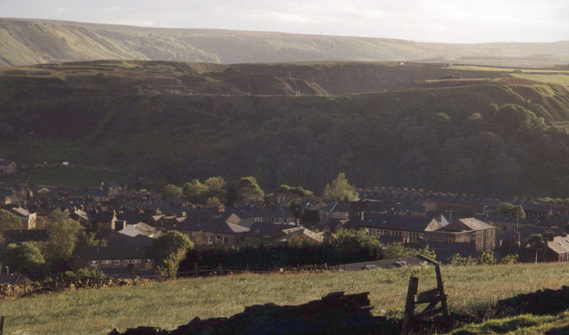
Haslingden
Haslingden /ˈhæzlɪŋdən/ is a town in Rossendale, Lancashire, England. It is 16 miles (26 km) north of Manchester. The name means 'valley of the hazels' or 'valley growing with hazels'. At the time of the 2011 census the town (including Helmshore) had a population of 15,969. The town is surrounded by high moorland; 370 m (1215 ft) to the north; 396 m (1300 ft) Cribden to the east; 418 m (1372 ft) Bull Hill to the south.
Haslingden is the birthplace of the industrialist John Cockerill (1790–1840) and the composer Alan Rawsthorne (1905–1971), and was the home for many years of the Irish Republican leader, Michael Davitt (1846–1906). Haslingden Cricket Club is a member of the Lancashire League.
There is some evidence of Bronze Age human presence in the area of Haslingden. Thirteen Stones Hill is 2 km (1.2 mi) west of the town and probably dates from about 3000BC. There is now just one stone visible.
Part of what is now Haslingden, along with the neighbouring towns of Rawtenstall and beyond that Bacup were part of the Forest of Rossendale, itself part of the Forest of Blackburnshire. During the late 13th and 14th centuries the Forest was a hunting park; the term 'Forest' referred to it being parkland rather than being heavily wooded, as the forest declined much earlier, during the Neolithic period. The Forest of Rossendale contained eleven vaccaries (cow-pastures) and was poorly populated, with Haslingden being the only town of significance and possessed of a church.
Haslingden appears to have held markets during the sixteenth century, with the first reference in a Court Roll of 1555 where it records a John Radcliffe being fined for being a 'forestaller of the lords market of Haslyngden'. There are later references to markets and fairs in The Shuttleworth Accounts (1582-1621) and the map-maker Richard Blome writing in 1673 describes Haslingden as originally having 'a small Market-town on Wednesdays', and later, at the time of Charles I, the market had been moved to Saturday. The market continued to grow and Haslingden was designated a Market Town in 1676. It became a coaching station and a significant industrial borough during the Industrial Revolution. Haslingden benefitted in particular with the mechanisation of the wool and cotton spinning and weaving industries from the 18th to the 19th centuries, and the development of watermills, and later steam power. By the latter half of the nineteenth century, the diversity and wealth of industry earned the area the name 'The Golden Valley'. In the 20th century the population declined from 19,000 in the 1911 census to 15,000 in the 1971 census. The 2001 census recorded a population of 16,849 living in the town.
Haslingden is notable for its stone quarrying, and Haslingden Flag (a quartz-based sandstone) was distributed throughout the country in the 19th century with the opening up of the rail network. This stone was used in the paving of London, including Trafalgar Square. Flagstone is a type of sedimentary rock, relatively easy to split or quarry in slabs, and hence ideal for paving. Locally it is also used for making fences and roofing. Geologists have found that it has a hardness and silica content not unlike granite, and its presence was the main reason for the growth of quarrying in Rossendale. Haslingden Flag is unique; two other, common types of flagstone ('rough rocks') are found throughout the Pennines, but a third type is found only in the local Haslingden Flags.
Like much of East Lancashire, Haslingden has a long association with the textile industry. From the 16th century, after the old Forest of Rossendale was opened up to settlement, farmers raised sheep on the moorlands and made woollen cloth. Initially this was small-scale and local but towards the end of the 18th century cloth workers came together to work in small groups of houses. At the same time advances in technology meant that the first mills were appearing in the area. Most of these were small, water-powered buildings; and Haslingden, with its elevated situation, was not a natural place for the development of these early mills. Locally they were situated lower down in the river valleys, such as at nearby Helmshore.
The long association with wool meant that Haslingden and the other Rossendale towns had expertise with the processes of cloth production, and so were able to switch easily to cotton weaving. Cotton was better suited than wool to industrialised spinning as its fibres were less likely to break than wool. Cotton cloth manufacture quickly became a highly successful industry, and its development was closely associated with its role in the expansion of the slave trade. African slaves being bartered for cotton goods, and cotton being picked by slaves in the Deep South of the U.S.
Hub AI
Haslingden AI simulator
(@Haslingden_simulator)
Haslingden
Haslingden /ˈhæzlɪŋdən/ is a town in Rossendale, Lancashire, England. It is 16 miles (26 km) north of Manchester. The name means 'valley of the hazels' or 'valley growing with hazels'. At the time of the 2011 census the town (including Helmshore) had a population of 15,969. The town is surrounded by high moorland; 370 m (1215 ft) to the north; 396 m (1300 ft) Cribden to the east; 418 m (1372 ft) Bull Hill to the south.
Haslingden is the birthplace of the industrialist John Cockerill (1790–1840) and the composer Alan Rawsthorne (1905–1971), and was the home for many years of the Irish Republican leader, Michael Davitt (1846–1906). Haslingden Cricket Club is a member of the Lancashire League.
There is some evidence of Bronze Age human presence in the area of Haslingden. Thirteen Stones Hill is 2 km (1.2 mi) west of the town and probably dates from about 3000BC. There is now just one stone visible.
Part of what is now Haslingden, along with the neighbouring towns of Rawtenstall and beyond that Bacup were part of the Forest of Rossendale, itself part of the Forest of Blackburnshire. During the late 13th and 14th centuries the Forest was a hunting park; the term 'Forest' referred to it being parkland rather than being heavily wooded, as the forest declined much earlier, during the Neolithic period. The Forest of Rossendale contained eleven vaccaries (cow-pastures) and was poorly populated, with Haslingden being the only town of significance and possessed of a church.
Haslingden appears to have held markets during the sixteenth century, with the first reference in a Court Roll of 1555 where it records a John Radcliffe being fined for being a 'forestaller of the lords market of Haslyngden'. There are later references to markets and fairs in The Shuttleworth Accounts (1582-1621) and the map-maker Richard Blome writing in 1673 describes Haslingden as originally having 'a small Market-town on Wednesdays', and later, at the time of Charles I, the market had been moved to Saturday. The market continued to grow and Haslingden was designated a Market Town in 1676. It became a coaching station and a significant industrial borough during the Industrial Revolution. Haslingden benefitted in particular with the mechanisation of the wool and cotton spinning and weaving industries from the 18th to the 19th centuries, and the development of watermills, and later steam power. By the latter half of the nineteenth century, the diversity and wealth of industry earned the area the name 'The Golden Valley'. In the 20th century the population declined from 19,000 in the 1911 census to 15,000 in the 1971 census. The 2001 census recorded a population of 16,849 living in the town.
Haslingden is notable for its stone quarrying, and Haslingden Flag (a quartz-based sandstone) was distributed throughout the country in the 19th century with the opening up of the rail network. This stone was used in the paving of London, including Trafalgar Square. Flagstone is a type of sedimentary rock, relatively easy to split or quarry in slabs, and hence ideal for paving. Locally it is also used for making fences and roofing. Geologists have found that it has a hardness and silica content not unlike granite, and its presence was the main reason for the growth of quarrying in Rossendale. Haslingden Flag is unique; two other, common types of flagstone ('rough rocks') are found throughout the Pennines, but a third type is found only in the local Haslingden Flags.
Like much of East Lancashire, Haslingden has a long association with the textile industry. From the 16th century, after the old Forest of Rossendale was opened up to settlement, farmers raised sheep on the moorlands and made woollen cloth. Initially this was small-scale and local but towards the end of the 18th century cloth workers came together to work in small groups of houses. At the same time advances in technology meant that the first mills were appearing in the area. Most of these were small, water-powered buildings; and Haslingden, with its elevated situation, was not a natural place for the development of these early mills. Locally they were situated lower down in the river valleys, such as at nearby Helmshore.
The long association with wool meant that Haslingden and the other Rossendale towns had expertise with the processes of cloth production, and so were able to switch easily to cotton weaving. Cotton was better suited than wool to industrialised spinning as its fibres were less likely to break than wool. Cotton cloth manufacture quickly became a highly successful industry, and its development was closely associated with its role in the expansion of the slave trade. African slaves being bartered for cotton goods, and cotton being picked by slaves in the Deep South of the U.S.