_by_Klugschnacker_in_Wikipedia.jpg/250px-Kołobrzeg,_Hafen,_Leuchtturm,_f_(2011-07-26)_by_Klugschnacker_in_Wikipedia.jpg "Kołobrzeg")
_by_Klugschnacker_in_Wikipedia.jpg/2000px-Kołobrzeg,_Hafen,_Leuchtturm,_f_(2011-07-26)_by_Klugschnacker_in_Wikipedia.jpg)
Community hub
Recent from talks
Contribute something
Nothing was collected or created yet.
Kołobrzeg
View on Wikipedia
Kołobrzeg (Polish: [kɔˈwɔbʐɛk] ⓘ; Kashubian: Kòlbrzég; German: Kolberg [ˈkɔlbɛʁk] ⓘ) is a port and spa city in the West Pomeranian Voivodeship in north-western Poland,[1] with about 47,000 inhabitants (as of 2014[update]). Kołobrzeg is located on the Parsęta River on the south coast of the Baltic Sea (in the middle of the section divided by the Oder and Vistula Rivers). It is the capital of Kołobrzeg County.
Key Information
_by_Klugschnacker_in_Wikipedia.jpg)
_by_Klugschnacker_in_Wikipedia.jpg)


During the Early Middle Ages, the Pomeranian tribes established a settlement at the site of modern-day Budzistowo. In 1000, when the city was part of Poland, it became the seat of the Diocese of Kołobrzeg, one of five oldest Polish dioceses. During the High Middle Ages, the town was expanded with an additional settlement inhabited by German settlers a few kilometers north of the stronghold and chartered with Lübeck law, which settlement eventually superseded the original Pomeranian settlement. The city later joined the Hanseatic League. Within the Duchy of Pomerania the town was the urban center of the secular reign of the prince-bishops of Kamień and their residence throughout the High and Late Middle Ages. In the modern age, it passed to Brandenburg and Prussia, and withstood a Polish-French siege in 1807. In the late 19th century it became a popular spa town at the Baltic Sea. In 1945, Polish and Soviet troops captured the town. Kołobrzeg, now part of post-war Poland and devastated in the preceding battle, was rebuilt, but lost its status as the regional center to the nearby city of Koszalin.
Etymology
[edit]"Kołobrzeg" (and its Kashubian equivalent "Kòłobrzeg") translates as 'by the shore'; koło means 'by',[2] and brzeg means 'shore'.[3] Its original name, Cholberg, was taken by Polish and Kashubian linguists in the 19th and 20th centuries to reconstruct the name. After German settlement, "Cholberg" evolved into "Kolberg".[citation needed]
History
[edit]Pomeranian stronghold at modern Budzistowo
[edit]According to Piskorski (1999) and Kempke (2001), Slavic and Lechitic immigration reached Farther Pomerania in the 7th century.[4][5] First Slavic settlements in the vicinity of Kołobrzeg were centered around nearby deposits of salt and date to 6th and 7th century.[6][7]
In the late 9th century, the Pomeranian tribes erected a fortified settlement at the site of modern part of Kołobrzeg county called Budzistowo[8] near modern Kołobrzeg,[9] replacing nearby Bardy-Świelubie, a multi-ethnic emporium, as the center of the region.[10] The Parseta valley, where both the emporium and the stronghold were located, was one of the Pomeranians' core settlement areas.[11] The stronghold consisted of a fortified burgh with a suburbium.[12][13]
The Pomeranians mined salt[14] in salt pans located in two downstream hills.[15][16] They also engaged in fishing, and used the salt to conserve foodstuffs, primarily herring, for trade.[16][17] Other important occupations were metallurgy and smithery, based on local iron ore reserves, other crafts like the production of combs from horn, and in the surrounding areas, agriculture.[16][18] Important sites in the settlement were a place for periodical markets and a tavern, mentioned as forum et taberna in 1140.[14]
In the 9th and 10th centuries, the Budzistowo stronghold was the largest of several smaller ones in the Persante area, and as such is thought to have functioned as the center of the local Pomeranian subtribe.[18] By the turn from the 10th to the 11th century, the smaller burghs in the Parseta area were given up.[18] With the area coming under the control of the Polish Duke Mieszko I, only two strongholds remained and underwent an enlargement, the one at Budzistowo and a predecessor of later Białogard.[18] These developments were most likely associated with the establishment of Polish power over this part of the Baltic coast. In the 10th century, the trade of salt and fish led to the development of the settlement into a town.[19]
Piast Poland and conversion
[edit]
During Polish rule of the area in the late 10th century, the chronicle of Thietmar of Merseburg (975–1018) mentions salsa Cholbergiensis as the see of the Bishopric of Kołobrzeg, set up during the Congress of Gniezno in 1000 and placed under the Archdiocese of Gniezno.[9] The congress was organized by Polish duke Bolesław Chrobry and Holy Roman Emperor Otto III, and also led to the establishment of bishoprics in Kraków and Wrocław, connecting the territories of the Polish state.[19] It was an important event not only in religious, but also political dimension in the history of the early Polish state, as it unified and organized medieval Polish territories.[19]
The missionary efforts of bishop Reinbern were not successful, the Pomeranians revolted in 1005 and regained political and spiritual independence.[20][21][22][23] In 1013 Bolesław Chrobry removed his troops from Pomerania in face of war with Holy Roman Emperor Henry III.[7] The Polish–German war ended with Polish victory, which was confirmed by the 1018 Peace of Bautzen.
During his campaigns in the early 12th century, Bolesław III Wrymouth reacquired Pomerania for Poland, and made the local Griffin dynasty his vassals. The stronghold was captured by the Polish army in the winter of 1107/08, when the inhabitants (cives et oppidani) including a duke (dux Pomeranorum) surrendered without resistance.[24] A previous Polish siege of the burgh had been unsuccessful; although the duke had fled the burgh, the Polish army was unable to break through the fortifications and the two gates.[25] The army had however looted and burned the suburbium, which was not or only lightly fortified.[25] The descriptions given by the contemporary chroniclers make it possible that a second, purely militarily used castle existed near the settlement, yet neither is this certain nor have archaeological efforts been able to locate traces thereof.[26] In the 12th-century Polish chronicle Gesta principum Polonorum Kołobrzeg was named a significant and famous city.
During the subsequent Christianization of the area by Otto of Bamberg at the behest of Bolesław, a St. Mary's church was built.[8] This marked the first beginnings of German influence in the area.[19] After Bolesław's death, as a result of the fragmentation of Poland, the Duchy of Pomerania became independent,[27] before the dukes became vassals of Denmark in 1185 and the Holy Roman Empire in 1227.
Besides St. Mary's, a St. John's church and a St. Petri's chapel were built.[14] A painting of the town of Kołobrzeg from the 13th century is located in the Museum of Polish Arms in the city.[28]
From the late Middle Ages to the Thirty Years' War
[edit]

During the Ostsiedlung, a settlement was founded by German settlers some kilometres off the site of the Slavic/Lechitic one.[29][30][31] It was located within the boundaries of today's downtown of Kołobrzeg and some of the inhabitants of the Polish town moved to the new settlement.[19] On 23 May 1255 it was chartered under Lübeck law by Duke Wartislaw III of Pomerania,[32][33] and more settlers arrived, attracted by the duke.[30] Hermann von Gleichen, German bishop of Kammin also supported the German colonisation of the region.[19] The settlers received several privileges such as exemption from certain taxes and several benefits, making it difficult for the indigenous Pomeranian population to compete with Germans.[19]
Henceforth, the nearby former stronghold was turned into a village and renamed "Old Town" (Latin: antiqua civitatae Colbergensis, German: Altstadt, Polish: Stare Miasto), first documented in 1277 and used until 1945 when it was renamed "Budzistowo".[8][12] A new St. Mary's church was built within the new town before the 1260s,[34] while St. Mary's in the former Pomeranian stronghold was turned into a nuns' abbey.[8] In 1277 St. Benedict's monastery for nuns was founded, which in the framework of the Pomeranian Reformation in 1545 was then changed into an educational institution for noble Protestant ladies.[35]

Already in 1248, the Kammin bishops and the Pomeranian dukes had interchanged the terrae Stargard and Kolberg, leaving the bishops in charge of the latter.[36] When in 1276 they became the souvereign of the town also, they moved their residence there, while the administration of the diocese was done from nearby Köslin (Koszalin).[36] In 1345, the bishops became Imperial immediate dukes in their secular reign.[36]
In 1361, the city joined the Hanseatic League. In 1446 it fought a battle against the nearby rival city of Koszalin.[37]
When the property of the Bishopric of Kammin was secularized during the Protestant Reformation in 1534, their secular reign including the Kolberg area became intermediately ruled by a Lutheran titular bishop, before it was turned into a Sekundogenitur of the House of Pomerania.[36]
In the 15th century the city traded with Scotland, Amsterdam and Scandinavia.[19] Beer, salt, honey, wool and flour were exported, while merchants imported textiles from England, southern fruits, and cod liver oil. In the 16th century, the city reached 5,000 inhabitants.[19] The indigenous Slavs in the city were discriminated, and their rights in trade and crafts were limited, with bans on performing certain types of professions and taking certain positions in the city,[19][citation needed] for instance in 1564 it was forbidden to admit native Slavs to the blacksmiths' guild.[38]
During the Thirty Years' War, Kolberg was occupied by imperial forces from 1627 to 1630,[39] and thereafter by Swedish forces.[40]
Modern era: In Prussia
[edit]
Kolberg, with most of Farther Pomerania, was granted to Brandenburg-Prussia in 1648 by the Treaty of Westphalia and, after the signing of the Treaty of Stettin (1653), and in accordance with the Treaty of Grimnitz, was part of the Province of Pomerania. In the 1690s, French Huguenot immigrants and merchants from the Netherlands settled in the city, however, due to the bankruptcy of the merchants, the hired French preacher left for Warsaw in 1700, and several merchants went back to the Netherlands.[41] It became part of the Kingdom of Prussia in 1701. In the 18th century, trade with Poland declined, while the production of textiles was developed.[7] In 1761, during the Seven Years' War, the town was captured after three subsequent sieges by the Russian commander Peter Rumyantsev. At the end of the war, however, Kolberg was returned to Prussia.

In the Napoleonic Wars, during Napoleon's invasion of Prussia during the War of the Fourth Coalition, the town was besieged from mid-March to 2 July 1807 by the Grande Armée and by insurgents from Poland against Prussian rule (a street named after General Antoni Paweł Sułkowski, who led Polish troops, is located within the present-day city). As a result of forced conscription, some Poles were also among Prussian soldiers during the battle.[19] The city's defense, led by then Lieutenant-Colonel August von Gneisenau, held out until the war was ended by the Treaty of Tilsit. Kolberg was returned to the Prussian province of Pomerania in 1815, after the final defeat of Napoleon; until 1872, it was administered within the Fürstenthum District ("Principality District", recalling the area's former special status), then it was within Landkreis Kolberg-Körlin. Marcin Dunin, Archbishop of Poznań and Gniezno and Roman Catholic primate of Poland, was imprisoned for sedition by the Prussian authorities for ten months in 1839–1840 in the city[42] and after his release, he tried to organise a chaplaincy for the many Polish soldiers stationed in Kolberg.[43]
In the 19th century the city had a small but active Polish population that increased during the century to account for 1.5% of the population by 1905.[44] The Polish community funded a Catholic school and the Church of Saint Marcin where masses were held in Polish (initially throughout the season, after about 1890 all year).[7][45][46] Dating back to 1261 Kolberg's Jewish population amounted to 528 people in 1887, rising to 580 two years later, and although many moved to Berlin after that date they numbered around 500 by the end of the Nineteenth century[47]
Between 1924 and 1935, the American-German painter Lyonel Feininger, a tutor at the Staatliches Bauhaus, visited Kolberg repeatedly and painted the cathedral and environs of the town.
In the May elections of 1933, the Nazi Party received by far the most votes, 9,842 out of 19,607 cast votes.[48]

When the Nazis took power in Germany in 1933, the Jewish community in Kolberg comprised 200 people, and the antisemitic repression by Germany's ruling party led several of them to flee the country. A Nazi newspaper, the Kolberger Beobachter, listed Jewish shops and business that were to be boycotted. Nazis also engaged in hate propaganda against Jewish lawyers, doctors, and craftsmen.[49] At the end of 1935, Jews were banned from working in the city's health spas.[49] During Kristallnacht, the Jewish synagogue and homes were destroyed, and in 1938 the local Jewish cemetery was vandalised, while a cemetery shrine was turned to stable by German soldiers.[50] In 1938, all Jews in Kolberg, as all over Germany, were renamed in official German documents as "Israel" (for males) or "Sarah" (for females). In the beginning of 1939, Jews were banned from attending German schools and the entire adult population had its driving licenses revoked.[49] After years of discrimination and harassment, local Jews were deported by the German authorities to concentration camps in 1940.
Second World War
[edit]
During World War II the German state brought in numerous forced laborers to the city, among them many Poles.[19] The city's economy was changed to military production-especially after the German invasion of the Soviet Union.[19] The forced laborers were threatened with everyday harassment and repression; they were forbidden from using phones, holding cultural events and sports events, they could not visit restaurants or swimming pools, or have contact with the local German population.[19] Poles were only allowed to attend a church mass once a month – and only in the German language.[19] They also had smaller food rations than Germans, and had to wear a sign with the letter P on their clothes indicating their ethnic background.[19] Additionally, medical help for Polish workers was limited by the authorities.[19] Arrests and imprisonment for various offences, such as "slow pace of work" or leaving the workspace, were everyday occurrences.[51] A labour subcamp of the Stalag II-D prisoner-of-war camp for Allied POWs was also operated in the city by Germany.[52]
In 1944, the city was selected as a fortress — Festung Kolberg. The 1807 siege was used for the last Nazi propaganda film, Kolberg shortly before the end of the war by Joseph Goebbels. It was meant to inspire the Germans with its depiction of the heroic Prussian defence during the Napoleonic Wars. Tremendous resources were devoted to filming this epic, even diverting tens of thousands of troops from the front lines to have them serve as extras in battle scenes. Ironically, the film was released in the final few weeks of Nazi Germany's existence, when most of the country's cinemas were already destroyed.
On 10 February 1945, the German torpedo-boat T-196 brought about 300 survivors of the General von Steuben, which had been sunk by Soviet submarine S-13 to Kolberg. As the Red Army advanced on Kolberg, most of the inhabitants and tens of thousands of refugees from surrounding areas (about 70,000 were trapped in the Kolberg Pocket), as well as 40,000 German soldiers, were evacuated from the besieged city by German naval forces in Operation Hannibal. Only about two thousand soldiers were left on 17 March to cover the last sea transports.
Between 4 and 18 March 1945, there were major battles between the Soviet and Polish forces and the German army. Because of a lack of anti-tank weapons, German destroyers used their guns to support the defenders of Kolberg until nearly all of the soldiers and civilians had been evacuated. During the fights, Polish soldiers' losses were 1,013 dead, 142 MIA and 2,652 wounded.[19] On 18 March, the Polish Army re-enacted Poland's Wedding to the Sea ceremony, which had been celebrated for the first time in 1920 by General Józef Haller.
After the battle the city for several weeks was under Soviet administration, the Germans that had not yet fled were expelled and the city was plundered by the Soviet troops.[19] Freed Polish forced laborers remained and were joined by Polish railwaymen from Warsaw destroyed by the Germans.[19]
- Before, during, and after the war
-
 Kolberg between 1890 and 1905
 -
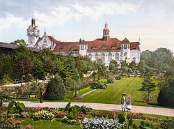 Strandschloss (Beach Castle) in Kolberg c. 1900
 -
 80% of the city destroyed in 1945
 -
 Ratuszowy Square, Kołobrzeg in 2019


Post-war Poland
[edit]
After World War II the region became again part of Poland, under territorial changes demanded by the Soviet Union and the Soviet-installed Polish Communist regime at the Potsdam Conference. Most Germans that had not yet fled were expelled from their homes in accordance with the Potsdam Agreement. The town was resettled by Polish citizens, many of whom were themselves Polish refugees from regions east of former eastern Poland annexed by the Soviet Union, from where they had been displaced by Soviet authorities.
In 2000 the city business council of Kołobrzeg commissioned a monument called the Millennium Memorial as a commemoration of "1000 years of Christianity in Pomerania", and as a tribute to Polish-German Reconciliation, celebrating the meeting of King Bolesław I of Poland and King Otto III of Germany, at the Congress of Gniezno, in the year 1000. It was designed and built by the artist Wiktor Szostalo in welded stainless steel. The two figures sit at the base of a 5-meter cross, cleft in two and being held together by a dove holding an olive branch. It is installed outside the Basilica Cathedral in the city center.
Climate
[edit]Kołobrzeg has an oceanic climate (Köppen climate classification: Cfb).[53][54]
| Climate data for Kołobrzeg (1991–2020 normals, extremes 1951–present) | |||||||||||||
|---|---|---|---|---|---|---|---|---|---|---|---|---|---|
| Month | Jan | Feb | Mar | Apr | May | Jun | Jul | Aug | Sep | Oct | Nov | Dec | Year |
| Record high °C (°F) | 15.3 (59.5) |
17.8 (64.0) |
23.2 (73.8) |
28.9 (84.0) |
31.7 (89.1) |
35.9 (96.6) |
35.7 (96.3) |
38.0 (100.4) |
32.3 (90.1) |
26.1 (79.0) |
19.5 (67.1) |
14.3 (57.7) |
38.0 (100.4) |
| Mean maximum °C (°F) | 9.1 (48.4) |
10.3 (50.5) |
15.9 (60.6) |
22.3 (72.1) |
26.7 (80.1) |
28.9 (84.0) |
30.0 (86.0) |
30.2 (86.4) |
24.8 (76.6) |
19.1 (66.4) |
13.2 (55.8) |
9.9 (49.8) |
32.4 (90.3) |
| Mean daily maximum °C (°F) | 2.9 (37.2) |
3.8 (38.8) |
6.8 (44.2) |
11.8 (53.2) |
15.9 (60.6) |
19.3 (66.7) |
21.7 (71.1) |
22.0 (71.6) |
18.1 (64.6) |
12.9 (55.2) |
7.5 (45.5) |
4.1 (39.4) |
12.2 (54.0) |
| Daily mean °C (°F) | 0.7 (33.3) |
1.2 (34.2) |
3.4 (38.1) |
7.6 (45.7) |
11.8 (53.2) |
15.6 (60.1) |
17.9 (64.2) |
17.9 (64.2) |
14.1 (57.4) |
9.5 (49.1) |
5.1 (41.2) |
2.0 (35.6) |
8.9 (48.0) |
| Mean daily minimum °C (°F) | −1.5 (29.3) |
−1.1 (30.0) |
0.7 (33.3) |
4.2 (39.6) |
8.1 (46.6) |
11.8 (53.2) |
14.2 (57.6) |
14.1 (57.4) |
10.8 (51.4) |
6.7 (44.1) |
3.0 (37.4) |
−0.2 (31.6) |
5.9 (42.6) |
| Mean minimum °C (°F) | −10.4 (13.3) |
−8.5 (16.7) |
−5.3 (22.5) |
−1.2 (29.8) |
2.4 (36.3) |
7.0 (44.6) |
10.1 (50.2) |
9.2 (48.6) |
5.2 (41.4) |
0.3 (32.5) |
−3.4 (25.9) |
−7.5 (18.5) |
−13.2 (8.2) |
| Record low °C (°F) | −23.9 (−11.0) |
−25.5 (−13.9) |
−17.7 (0.1) |
−5.5 (22.1) |
−2.6 (27.3) |
0.0 (32.0) |
4.4 (39.9) |
2.4 (36.3) |
−0.7 (30.7) |
−5.5 (22.1) |
−13.1 (8.4) |
−18.3 (−0.9) |
−25.5 (−13.9) |
| Average precipitation mm (inches) | 48.2 (1.90) |
40.5 (1.59) |
42.9 (1.69) |
34.0 (1.34) |
50.6 (1.99) |
70.4 (2.77) |
77.0 (3.03) |
89.9 (3.54) |
73.2 (2.88) |
64.9 (2.56) |
51.0 (2.01) |
55.0 (2.17) |
697.7 (27.47) |
| Average extreme snow depth cm (inches) | 4.7 (1.9) |
5.0 (2.0) |
3.0 (1.2) |
0.2 (0.1) |
0.0 (0.0) |
0.0 (0.0) |
0.0 (0.0) |
0.0 (0.0) |
0.0 (0.0) |
0.2 (0.1) |
1.3 (0.5) |
3.4 (1.3) |
5.0 (2.0) |
| Average precipitation days (≥ 0.1 mm) | 17.67 | 15.69 | 14.00 | 11.07 | 12.80 | 13.13 | 14.00 | 14.07 | 13.70 | 15.60 | 16.20 | 18.77 | 176.69 |
| Average snowy days (≥ 0 cm) | 9.3 | 9.2 | 3.9 | 0.1 | 0.0 | 0.0 | 0.0 | 0.0 | 0.0 | 0.1 | 1.5 | 5.7 | 29.8 |
| Average relative humidity (%) | 85.1 | 83.7 | 81.4 | 77.0 | 77.6 | 77.2 | 79.3 | 79.5 | 81.8 | 84.3 | 87.1 | 86.9 | 81.7 |
| Mean monthly sunshine hours | 42.7 | 66.8 | 127.8 | 198.9 | 255.6 | 253.0 | 255.1 | 236.5 | 163.3 | 104.9 | 47.9 | 30.6 | 1,783.1 |
| Source 1: Institute of Meteorology and Water Management[55][56][57][58][59][60][61][62] | |||||||||||||
| Source 2: Meteomodel.pl (records, relative humidity 1991–2020)[63][64][65] | |||||||||||||
Demographics
[edit]
Before the end of World War II the town was predominantly German Protestant with Polish and Jewish minorities. Almost all of the pre-war German population fled or was expelled so that since 1945, Polish Catholics make up the majority of the population. Around the turn from the 18th to the 19th century an increase of the number of Catholics was observed, because military personnel had been moved from West Prussia to the town.[citation needed]
|
| ||||||||||||||||||||||||||||||||||||||||||||||||||||||||||||||||||||||||
| Source: [66] | |||||||||||||||||||||||||||||||||||||||||||||||||||||||||||||||||||||||||

Tourist destination
[edit]Kołobrzeg today is a popular tourist destination for Poles, Germans and due to the ferry connection to Bornholm also Danish people. It provides a unique combination of a seaside resort, health resort, an old town full of historic monuments and tourist entertainment options (e.g. numerous "beer gardens").

Bike path to Podczele
[edit]The town is part of the European Route of Brick Gothic[67] network. A bike path "to Podczele", located along the seaside was commissioned on 14 July 2004. The path extends from Kołobrzeg to Podczele. The path has been financed by the European Union, and is intended to be part of a unique biking path that will ultimately circle the entire Baltic Sea.[68][69] The path was breached on 24 March 2010 due to the encroachment of the sea associated with the draining of the adjacent unique Eco-Park marsh area. The government of Poland has allocated PLN 90,000 to repair the breach, and the path re-opened within a year. It was also extended in 2011 to connected with Ustronie Morskie 8 km (5 mi) to the east.
Oldest oak
[edit]South of Bagicz, some 4 km (2 mi) from Kołobrzeg, there is an 806-year-old oak (2008). Dated in the year 2000 as the oldest oak in Poland, it was named Bolesław to commemorate the king Boleslaus the Brave.
Cultural center
[edit]Kołobrzeg is also a regional cultural center. In the summer take place – a number of concerts of popular singers, musicians, and cabarets. Municipal Cultural Center, is located in the Park teatralny. Keep under attachment artistic arts, theater and dance. Patron of youth teams and the vocal choir. Interfolk organizes the annual festival, the International Meeting of the folklore and other cultural events. Cinema is a place for meetings Piast Discussion Film Club.
In Kołobrzeg there are many permanent and temporary exhibitions of artistic and historical interest. In the town hall of Kołobrzeg is located Gallery of Modern Art, where exhibitions are exposed artists from Kołobrzeg, as well as outside the local artistic circles. Gallery also conducts educational activities, including organized by the gallery of art lessons for children and young people from schools.
Pier
[edit]
The Kołobrzeg Pier is currently the second longest pier in the West Pomeranian Voivodeship, after the pier in Międzyzdroje. A jetty positioned on the end of the pier enables small ships to sail for sightseeing excursions.[70]
Museums
[edit]
In town, there is a museum of Polish weapons (Muzeum Oręża Polskiego), which are presented in the collections of militaria from the early Middle Ages to the present. The palace of Braunschweig include part of museum dedicated to the history of the city. In their collections branch presents a collection of rare and common measurement tools, as well as specific measures of the workshop. The local museum is also moored at the port of ORP Fala patrol ship, built in 1964, after leaving the service transformed into a museum.
Transport
[edit]Train connections
[edit].JPG)
Kołobrzeg has connections among others to Szczecin, "Solidarity" Szczecin–Goleniów Airport, Gdańsk, Poznań, Warsaw, Kraków and Lublin.
Ferry
[edit]A seasonal ferry service to Nexø on the Danish island of Bornholm is offered by the catamaran Jantar.[71] The trip takes 4,5 hours[72] and carries passengers but no cars.
Sport
[edit]- SKK Kotwica Kołobrzeg – basketball club, which in the 2000s and 2010s competed in the Polish Basketball League, country's top flight
- Kotwica Kołobrzeg – football club
- Viktoria Kolberg - former German football club, dissolved in 1945
Notable people
[edit]

- Petrus Pachius (1579–1641/42) a German Protestant minister, teacher and poet
- Karl Wilhelm Ramler (1725–1798) German poet, translator and director at Berlin theater [73]
19th century
[edit]- Hermann Plüddemann (1809–1868) a German historical painter
- Ernst Maass (1856–1929) a German classical philologist.
- Magnus Hirschfeld (1868–1935), physician, sociologist and early 20th century Gay rights campaigner
- Paul Oestreich (1878–1959), educator, reformer
- Arnold Zadikow (1884–1943), German-Jewish sculptor
- Hans-Jürgen Stumpff (1889–1968), German general of Luftwaffe, co-signer of unconditional surrender 8 May 1945 in Berlin
- Günther Angern (1893–1943), Wehrmacht general
20th century
[edit]- Werner Krüger (1910–2003), German engineer, invented Krueger flap in 1943
- Erika von Brockdorff (1911–1943), German resistance fighter
- Karl-Heinz Marbach (1917–1995), German U-boat commander
- Egon Krenz (born 1937), last communist leader of East Germany
- Christine Lucyga (born 1944), politician
- Joanna Nowicka (born 1966) a Polish archer, competed in four consecutive Summer Olympics from 1988.
- Sebastian Karpiniuk (1972–2010) a Polish politician, an assistant to President of Kołobrzeg, died in plane crash
- Dariusz Trafas (born 1972), athlete, javelin throw national record holder
- Daria Korczyńska (born 1981) a retired track and field sprint athlete
- Robert Szpak (born 1989), athlete, javelin throw, 2008 World Junior Champion
Famous persons connected with the city
[edit]- Marcin Dunin (1774–1842) archbishop of Poznań and Gniezno, primate of Poland. Imprisoned in the fortress in the city[43]
- Friedrich Ludwig Jahn, (1778–1852), father of gymnastics, was imprisoned in Kolberg fortress in the 1820s [74][75]
- Adolf von Lützow, (1782–1834) a Prussian officer, served with distinction in the siege of Kolberg in 1807 [76]
- Wiktor Szostalo, (born 1952) sculptor and former Solidarity activist.
- Jan Pogány, (born 1960) classical composer, conductor and cellist.
- Ryszard Kukliński, (1930–2004) colonel and spy for NATO in the Cold War period, attended high school in the city.
International relations
[edit]Twin towns – sister cities
[edit]Kołobrzeg is twinned with:
 Bad Oldesloe, Germany
- Barth, Germany
- Berlin Pankow, Germany
 Feodosia, Ukraine
 Follonica, Italy
 Koekelberg, Belgium
 Landskrona, Sweden
 Nexø, Denmark
- Nyborg, Denmark
 Pori, Finland
- Simrishamn, Sweden
See also
[edit]Notes
[edit]References
[edit]- ^ "Główny Urząd Statystyczny" [Central Statistical Office] (in Polish). To search: Select "Miejscowości (SIMC)" tab, select "fragment (min. 3 znaki)" (minimum 3 characters), enter town name in the field below, click "WYSZUKAJ" (Search).
- ^ ADIPS Sp. z o.o. "DICT – English Polish Dictionary". Dict.pl. Archived from the original on 18 February 2012. Retrieved 8 July 2009.
- ^ ADIPS Sp. z o.o. "DICT – English Polish Dictionary". Dict.pl. Archived from the original on 18 February 2012. Retrieved 8 July 2009.
- ^ Piskorski, Jan Maria (1999). "Die Urgeschichte (bis zum Ende des 11. Jahrhunderts)". In Piskorski, Jan Maria (ed.). Pommern im Wandel der Zeiten (in German). Zamek Ksiazat Pomorskich. p. 29. ISBN 978-8390618487.
- ^ Kempke, Torsten (2001). "Skandinavisch-slawische Kontakte an der südlichen Ostseeküste". In Harck, Ole; Lübke, Christian (eds.). Zwischen Reric und Bornhöved: Die Beziehungen zwischen den Dänen und ihren slawischen Nachbarn vom 9. Bis ins 13. Jahrhundert: Beiträge einer internationalen Konferenz, Leipzig, 4.-6. Dezember 1997 (in German). Franz Steiner Verlag. p. 15. ISBN 3-515-07671-9.
- ^ Tadeusz Gasztold, Hieronim Kroczyński, Hieronim Rybicki, Kołobrzeg: zarys dziejów, Wydaw. Poznańskie, 1979, ISBN 83-210-0072-X, p.8
- ^ a b c d [1] Archived 27 September 2009 at the Wayback Machine Historic calendar of the city's Official webpage
- ^ a b c d Winfried Schich, Ralf Gebuhr, Peter Neumeister, Wirtschaft und Kulturlandschaft: Gesammelte Beiträge 1977 bis 1999 zur Geschichte der Zisterzienser und der "Germania Slavica", BWV Verlag, 2007, p.280, ISBN 3-8305-0378-4
- ^ a b Gerhard Köbler, Historisches Lexikon der Deutschen Länder: die deutschen Territorien vom Mittelalter bis zur Gegenwart, 7th edition, C.H.Beck, 2007, p.341, ISBN 3-406-54986-1
- ^ Ole Harck, Christian Lübke, Zwischen Reric und Bornhöved: Die Beziehungen zwischen den Dänen und ihren slawischen Nachbarn vom 9. Bis ins 13. Jahrhundert: Beiträge einer internationalen Konferenz, Leipzig, 4.-6. Dezember 1997, Franz Steiner Verlag, 2001, pp.15,16, ISBN 3-515-07671-9
- ^ Jörg Jarnut, Peter Johanek, Die Frühgeschichte der europäischen Stadt im 11. Jahrhundert, Köln-Weimar-Wien 1998, pp.273–305, republished in Winfried Schich, Ralf Gebuhr, Peter Neumeister, Wirtschaft und Kulturlandschaft – Siedlung und Wirtschaft im Bereich der Germania Slavica, BWV Verlag, 2007, p.263, ISBN 3-8305-0378-4
- ^ a b Eckhard Müller-Mertens, Heidelore Böcker, Konzeptionelle Ansätze der Hanse-Historiographie, Porta Alba, 2003, p.133, ISBN 3-933701-06-6
- ^ Jörg Jarnut, Peter Johanek, Die Frühgeschichte der europäischen Stadt im 11. Jahrhundert, Köln-Weimar-Wien 1998, pp.273–305, republished in Winfried Schich, Ralf Gebuhr, Peter Neumeister, Wirtschaft und Kulturlandschaft – Siedlung und Wirtschaft im Bereich der Germania Slavica, BWV Verlag, 2007, p.277, ISBN 3-8305-0378-4
- ^ a b c Jörg Jarnut, Peter Johanek, Die Frühgeschichte der europäischen Stadt im 11. Jahrhundert, Köln-Weimar-Wien 1998, pp.273–305, republished in Winfried Schich, Ralf Gebuhr, Peter Neumeister, Wirtschaft und Kulturlandschaft – Siedlung und Wirtschaft im Bereich der Germania Slavica, BWV Verlag, 2007, p.282, ISBN 3-8305-0378-4
- ^ Jörg Jarnut, Peter Johanek, Die Frühgeschichte der europäischen Stadt im 11. Jahrhundert, Köln-Weimar-Wien 1998, pp.273–305, republished in Winfried Schich, Ralf Gebuhr, Peter Neumeister, Wirtschaft und Kulturlandschaft – Siedlung und Wirtschaft im Bereich der Germania Slavica, BWV Verlag, 2007, p.278, ISBN 3-8305-0378-4
- ^ a b c [2] Archived 27 December 2010 at the Wayback Machine 'Historical eras' Official webpage of the city: The local Slavic population engaged in fishery, salt trade and various crafts.
- ^ Jörg Jarnut, Peter Johanek, Die Frühgeschichte der europäischen Stadt im 11. Jahrhundert, Köln-Weimar-Wien 1998, pp.273–305, republished in Winfried Schich, Ralf Gebuhr, Peter Neumeister, Wirtschaft und Kulturlandschaft – Siedlung und Wirtschaft im Bereich der Germania Slavica, BWV Verlag, 2007, p.274, ISBN 3-8305-0378-4
- ^ a b c d Jörg Jarnut, Peter Johanek, Die Frühgeschichte der europäischen Stadt im 11. Jahrhundert, Köln-Weimar-Wien 1998, pp.273–305, republished in Winfried Schich, Ralf Gebuhr, Peter Neumeister, Wirtschaft und Kulturlandschaft – Siedlung und Wirtschaft im Bereich der Germania Slavica, BWV Verlag, 2007, p.289, ISBN 3-8305-0378-4
- ^ a b c d e f g h i j k l m n o p q r s t "Epoki Historyczne". Miasto Kołobrzeg (in Polish). Retrieved 21 March 2020.[permanent dead link]
- ^ Nora Berend, Christianization and the Rise of Christian Monarchy: Scandinavia, Central Europe and Rus' C. 900–1200, Cambridge University Press, 2007, p.293, ISBN 0-521-87616-8, ISBN 978-0-521-87616-2
- ^ David Warner, Ottonian Germany: The Chronicon of Thietmar of Merseburg, Manchester University Press, 2001, p.358, ISBN 0-7190-4926-1, ISBN 978-0-7190-4926-2
- ^ Michael Borgolte, Benjamin Scheller, Polen und Deutschland vor 1000 Jahren: Die Berliner Tagung über den"akt von Gnesen", Akademie Verlag, 2002, p.282, ISBN 3-05-003749-0, ISBN 978-3-05-003749-3
- ^ Michael Müller-Wille, Rom und Byzanz im Norden: Mission und Glaubenswechsel im Ostseeraum während des 8.-14. Jahrhunderts: internationale Fachkonferenz der deutschen Forschungsgemeinschaft in Verbindung mit der Akademie der Wissenschaften und der Literatur, Mainz: Kiel, 18.-25. 9. 1994, 1997, p.105, ISBN 3-515-07498-8, ISBN 978-3-515-07498-8
- ^ Jörg Jarnut, Peter Johanek, Die Frühgeschichte der europäischen Stadt im 11. Jahrhundert, Köln-Weimar-Wien 1998, pp.273–305, republished in Winfried Schich, Ralf Gebuhr, Peter Neumeister, Wirtschaft und Kulturlandschaft – Siedlung und Wirtschaft im Bereich der Germania Slavica, BWV Verlag, 2007, p.275, ISBN 3-8305-0378-4
- ^ a b Jörg Jarnut, Peter Johanek, Die Frühgeschichte der europäischen Stadt im 11. Jahrhundert, Köln-Weimar-Wien 1998, pp.273–305, republished in Winfried Schich, Ralf Gebuhr, Peter Neumeister, Wirtschaft und Kulturlandschaft – Siedlung und Wirtschaft im Bereich der Germania Slavica, BWV Verlag, 2007, pp.273–274, ISBN 3-8305-0378-4
- ^ Jörg Jarnut, Peter Johanek, Die Frühgeschichte der europäischen Stadt im 11. Jahrhundert, Köln-Weimar-Wien 1998, pp.273–305, republished in Winfried Schich, Ralf Gebuhr, Peter Neumeister, Wirtschaft und Kulturlandschaft – Siedlung und Wirtschaft im Bereich der Germania Slavica, BWV Verlag, 2007, pp.274 ff, ISBN 3-8305-0378-4
- ^ Joachim Herrmann, Die Slawen in Deutschland, Akademie-Verlag Berlin, 1985, pp.386
- ^ Nazwa Kołobrzeg Archived 6 February 2012 at the Wayback Machine Official website of the city
- ^ Werner Buchholz, Pommern, Siedler, 1999, p.75, ISBN 3-88680-272-8
- ^ a b Sebastian Brather, Archäologie der westlichen Slawen: Siedlung, Wirtschaft und Gesellschaft im früh- und hochmittelalterlichen Ostmitteleuropa, Walter de Gruyter, 2001, p.156, ISBN 3-11-017061-2
- ^ Torsten Kempke in Ole Harck, Christian Lübke, Zwischen Reric und Bornhöved: die Beziehungen zwischen den Dänen und ihren slawischen Nachbarn vom 9. bis ins 13. Jahrhundert : Beiträge einer internationalen Konferenz, Leipzig, 4.-6. Dezember 1997, Franz Steiner Verlag, 2001, p.16, ISBN 3-515-07671-9
- ^ Copy of the charter (in Latin), printed in Heinrich Gottfried Philipp Gengler, Codex juris Municipalis Germaniae Medii Aevi: Regesten und Urkunden zur Verfassungs- und Rechtsgeschichte der deutschen Städte im Mittelalter, F. Enke, 1863, p.609, free view Archived 30 November 2022 at the Wayback Machine
- ^ Gerhard Köbler, Historisches Lexikon der Deutschen Länder: die deutschen Territorien vom Mittelalter bis zur Gegenwart, 7th edition, C.H.Beck, 2007, p.341, ISBN 3-406-54986-1:"1255 erhielt die deutsche Siedlung nördlich der slawischen Siedlung Stadtrect von Lübeck."
- ^ Jörg Jarnut, Peter Johanek, Die Frühgeschichte der europäischen Stadt im 11. Jahrhundert, Köln-Weimar-Wien 1998, pp.273–305, republished in Winfried Schich, Ralf Gebuhr, Peter Neumeister, Wirtschaft und Kulturlandschaft – Siedlung und Wirtschaft im Bereich der Germania Slavica, BWV Verlag, 2007, p.280, ISBN 3-8305-0378-4
- ^ Franz Manthey: Polnische Kirchengeschichte. Hildesheim 1965, p. 31.
- ^ a b c d Gerhard Köbler, Historisches Lexikon der Deutschen Länder: die deutschen Territorien vom Mittelalter bis zur Gegenwart, 7th edition, C.H.Beck, 2007, p.113, ISBN 3-406-54986-1
- ^ "Kalendarium 750 lat Koszalina, Muzeum w Koszalinie" (in Polish). Retrieved 21 March 2020.
- ^ Tadeusz Gasztold, Hieronim Kroczyński, Hieronim Rybicki, Kołobrzeg: zarys dziejów, Wydaw. Poznańskie, 1979, ISBN 83-210-0072-X, p.27 (in Polish)
- ^ Langer, Herbert (2003). "Die Anfänge des Garnisionswesens in Pommern". In Asmus, Ivo; Droste, Heiko; Olesen, Jens E. (eds.). Gemeinsame Bekannte: Schweden und Deutschland in der Frühen Neuzeit (in German). Berlin-Hamburg-Münster: LIT Verlag. p. 403. ISBN 3-8258-7150-9.
- ^ Langer, Herbert (2003). "Die Anfänge des Garnisionswesens in Pommern". In Asmus, Ivo; Droste, Heiko; Olesen, Jens E. (eds.). Gemeinsame Bekannte: Schweden und Deutschland in der Frühen Neuzeit (in German). Berlin-Hamburg-Münster: LIT Verlag. p. 397. ISBN 3-8258-7150-9.
- ^ Muret, Eduard (1885). Geschichte der Französischen Kolonie in Brandenburg-Preußen, unter besonderer Berücksichtigung der Berliner Gemeinde. Aus Veranlassung der Zweihundertjährigen Jubelfeier am 29. Oktober 1885 (in German). Berlin. pp. 208–209.
{{cite book}}: CS1 maint: location missing publisher (link) - ^ Papiestwo wobec sprawy polskiej w latach 1772–1865: wybór źródeł Otton Beiersdorf Zaklad Narodowy im. Ossolinskich,1960 page 309
- ^ a b Na stolicy prymasowskiej w Gnieźnie i w Poznaniu: szkice o prymasach Polski w okresie niewoli narodowej i w II Rzeczypospolitej: praca zbiorowa Feliks Lenort Księgarnia Św. Wojciecha, 1984, pages 139–146
- ^ Hieronym Kroczyński: Dawny Kołobrzeg, Wydawnictwo Le Petit Café, page 52, Kołobrzeg 1999
- ^ "Związki Pomorza Zachodniego z Polską" page 100 Szymon Pałkowski, Wyższa Szkoła Inżynierska w Koszalinie 1996
- ^ Peter Jancke: "Kolberg, Führer durch eine untergegangene Stadt", Husum 2008, ISBN 978-3-89876-365-3
- ^ "Jewish community before 1989 Kołobrzeg". Museum of the History of Polish Jews. Retrieved 1 December 2012.
- ^ "Deutsche Verwaltungsgeschichte Pommern, Kreis Kolberg". Verwaltungsgeschichte.de. Retrieved 16 September 2011.
- ^ a b c "Kołobrzeg – Historia"Wirtualny Sztetl
- ^ Kołobrzeg – Historia Archived 23 July 2011 at the Wayback Machine Wirtualny Sztetl-Muzeum Historii Żydów Polskich
- ^ Kołobrzeg: zarys dziejówb Tadeusz Gasztold, Hieronim Kroczyński, Hieronim Rybicki – 1979 – page 72
- ^ Aniszewska, Jolanta (2011). "W obowiązku pamięci... Stalag II D i formy upamiętnienia jeńców wojennych w Stargardzie Szczecińskim". Łambinowicki rocznik muzealny (in Polish). 34. Opole: 21.
- ^ Kottek, Markus; Grieser, Jürgen; Beck, Christoph; Rudolf, Bruno; Rubel, Franz (2006). "World Map of the Köppen-Geiger climate classification updated" (PDF). Meteorologische Zeitschrift. 15 (3): 259–263. Bibcode:2006MetZe..15..259K. doi:10.1127/0941-2948/2006/0130.
- ^ Peel, M. C.; Finlayson B. L. & McMahon, T. A. (2007). "Updated world map of the Köppen–Geiger climate classification" (PDF). Hydrol. Earth Syst. Sci. 11 (5): 1633–1644. Bibcode:2007HESS...11.1633P. doi:10.5194/hess-11-1633-2007. ISSN 1027-5606.
- ^ "Średnia dobowa temperatura powietrza". Normy klimatyczne 1991-2020 (in Polish). Institute of Meteorology and Water Management. Archived from the original on 3 December 2021. Retrieved 11 February 2022.
- ^ "Średnia minimalna temperatura powietrza". Normy klimatyczne 1991-2020 (in Polish). Institute of Meteorology and Water Management. Archived from the original on 15 January 2022. Retrieved 11 February 2022.
- ^ "Średnia maksymalna temperatura powietrza". Normy klimatyczne 1991-2020 (in Polish). Institute of Meteorology and Water Management. Archived from the original on 15 January 2022. Retrieved 11 February 2022.
- ^ "Miesięczna suma opadu". Normy klimatyczne 1991-2020 (in Polish). Institute of Meteorology and Water Management. Archived from the original on 9 January 2022. Retrieved 11 February 2022.
- ^ "Liczba dni z opadem >= 0,1 mm". Normy klimatyczne 1991-2020 (in Polish). Institute of Meteorology and Water Management. Archived from the original on 15 January 2022. Retrieved 11 February 2022.
- ^ "Średnia grubość pokrywy śnieżnej". Normy klimatyczne 1991-2020 (in Polish). Institute of Meteorology and Water Management. Archived from the original on 15 January 2022. Retrieved 11 February 2022.
- ^ "Liczba dni z pokrywą śnieżna > 0 cm". Normy klimatyczne 1991-2020 (in Polish). Institute of Meteorology and Water Management. Archived from the original on 21 January 2022. Retrieved 11 February 2022.
- ^ "Średnia suma usłonecznienia (h)". Normy klimatyczne 1991-2020 (in Polish). Institute of Meteorology and Water Management. Archived from the original on 15 January 2022. Retrieved 11 February 2022.
- ^ "Kołobrzeg Absolutna temperatura maksymalna" (in Polish). Meteomodel.pl. 6 April 2018. Retrieved 11 February 2022.
- ^ "Kołobrzeg Absolutna temperatura minimalna" (in Polish). Meteomodel.pl. Retrieved 11 February 2022.
- ^ "Kołobrzeg Średnia wilgotność" (in Polish). Meteomodel.pl. Retrieved 11 February 2022.
- ^ Dokumentacja Geograficzna (in Polish). Vol. 3/4. Warszawa: Instytut Geografii Polskiej Akademii Nauk. 1967. p. 21.
- ^ "Europäische Route der Backsteingotik | Homepage". EuRoB. Archived from the original on 28 April 2009. Retrieved 5 May 2009.
- ^ "Preparing an EU Strategy for the Baltic Sea Region". Ministry of Foreign Affairs, Republic of Poland. Retrieved 25 December 2017.
- ^ "European Route of Brick Gothic". German National Tourist Board. Retrieved 25 December 2017.
- ^ "Kolobrzeg Pier 2019, #2 top things to do in kolobrzeg, west pomeranian voivodeship, reviews, best time to visit, photo gallery | HelloTravel Poland". www.hellotravel.com. Retrieved 25 December 2019.
- ^ "Promy na Bornholm / Rejsy na Bornholm / Prom Bornholm / Jak dojechać na Bornholm | bornholm.pl".
- ^ "Bornpol". Archived from the original on 27 April 2024. Retrieved 27 April 2024.
- ^ . Encyclopædia Britannica. Vol. 22 (11th ed.). 1911.
- ^ . Encyclopædia Britannica. Vol. 15 (11th ed.). 1911.
- ^ Christopher Clark, Iron Kingdom: The Rise and Downfall of Prussia, 1600–1947 (Harvard University Press, 2006: ISBN 0-674-02385-4), p. 402.
- ^ . Encyclopædia Britannica. Vol. 17 (11th ed.). 1911.
Bibliography
[edit]- (in German) Gustav Kratz: Die Städte der Provinz Pommern – Abriss ihrer Geschichte, zumeist nach Urkunden ("The Towns of the Province of Pomerania – Sketch of their History, mostly according to historical Records"). Berlin 1865 (reprinted in 1996 by Sändig Reprint Verlag, Vaduz, ISBN 3-253-02734-1; reprinted in 2011 by Kessinger Publishing, U.S.A., ISBN 1-161-12969-3), pp. 81–99 (online)
External links
[edit]- . Encyclopædia Britannica. Vol. 15 (11th ed.). 1911.
- Municipal website (in Polish, German, and English)
- History of the town on the tourist promotion site (in English)
- dutchy of Cassubia (in English)
| Seat |
|  |
|---|---|---|
| Other gminas | ||


| International | |
|---|---|
| National | |
| Geographic | |
| Other | |
Kołobrzeg
View on GrokipediaEtymology
Name origins and historical variants
The name Kołobrzeg originates from Pomeranian Slavic roots, combining elements akin to "koło" (near or by) and "brzeg" (shore, bank, or edge), descriptively indicating a location "near the shore" or "by the bank," likely alluding to the site's position at the mouth of the Parsęta River amid marshy terrain.[9] This etymology reflects the hydrological features of the early Slavic settlement, though some hypotheses link variants to local salt production or briny features, as the area was known for evaporating seawater into salt from at least the 8th century. The earliest attested form appears in Latin as Cholberg or Salsa Cholbergiensis (salt of Cholberg), recorded circa 1000 by the chronicler Thietmar of Merseburg in connection with the short-lived Bishopric of Kołobrzeg established during the Congress of Gniezno.[9] [10] Under German settlement and Hanseatic influence from the 13th century, the name evolved into Colberg or Kolberg in Low and High German, a phonetic adaptation of the Slavic precursor that persisted through Prussian and imperial eras, often rendered as Kolberg in maps and documents from the 17th century onward.[11] [12] Polish variants like Kolobrag or Kolobręg appeared sporadically in Piast-era records reflecting the region's intermittent Polish control, but these were not standardized until later.[13] The contemporary Polish orthography Kołobrzeg, with diacritics, was formalized in 1781 by the historian Adam Naruszewicz, who revived it to align with native linguistic forms amid Enlightenment-era interest in Slavic toponymy.[13] Following the city's transfer to Polish administration in 1945 after World War II, Kołobrzeg supplanted Kolberg as the exclusive official name, standardizing its use in all contexts.[11] Historical linguistic analyses, including 19th- and 20th-century reconstructions by Polish and Kashubian scholars, have posited Cholberg as the proto-form, bridging Slavic and Germanic usages without reliance on folk etymologies like unrelated "coal mountain" interpretations.[12]History
Prehistoric settlements and archaeology
The region surrounding Kołobrzeg exhibits evidence of Neolithic human occupation, primarily evidenced by the 2022 discovery of the "Venus of Kołobrzeg," a 12 cm limestone figurine dated to circa 4000 BCE through radiocarbon and stylistic analysis. Unearthed by a local farmer near the Parsęta River, the artifact features a stylized female form with exaggerated breasts and hips, interpreted as a fertility symbol akin to other European Neolithic venuses, though uniquely carved from stone rather than clay in this northern context.[14][15][16] Confirmed authentic in June 2025 via interdisciplinary examination at the Kołobrzeg City Museum, it marks the first such figurine recovered in Poland, suggesting cultural links to early farming communities along the Baltic littoral amid otherwise sparse local Neolithic remains.[17][18] Archaeological surveys indicate limited prehistoric settlement density prior to the Neolithic, with no substantial Bronze Age or Iron Age sites documented near Kołobrzeg, implying the area served more as a peripheral coastal zone rather than a hub for metallurgical or fortified communities during those eras. This paucity of finds contrasts with denser evidence in inland Pomerania, pointing to environmental factors like shifting dunes and riverine flooding as potential deterrents to sustained habitation. Current excavations prioritize the Venus context for further Neolithic probing, but yield primarily lithic tools and pottery shards consistent with mobile hunter-gatherer transitions to agriculture around 6000–5000 years ago.[19] Proto-historic activity emerges in the 7th–8th centuries CE with traces of fortified settlements on Solna Island, comprising earthen ramparts and wooden structures linked to early Pomeranian Slavic groups engaged in salt extraction, fishing, and amber trade. These precursors to urban development, spanning roughly 2–5 hectares, reflect defensive adaptations to the lagoonal landscape but lack written corroboration, distinguishing them from later medieval phases.[20][21] No artifacts indicate Roman military incursions or Viking raids in the vicinity, underscoring Kołobrzeg's marginal role in broader ancient networks until Slavic consolidation, as inferred from regional comparative archaeology.[14]Early medieval Pomeranian and Polish periods
The early medieval settlement of Pomeranian Slavs in the Kołobrzeg area centered on a fortified site at modern Budzistowo, located about 3 kilometers south of the present city center on the right bank of the Parsęta River.[20] This hill-fort, accompanied by open settlements, emerged as a regional stronghold amid Pomeranian tribal networks, with archaeological layers dating from the 8th century onward reflecting defensive earthworks and wooden structures typical of Slavic Pomeranian fortifications.[22] Salt extraction from local coastal sources underpinned the site's economic viability, with evidence of production facilities active from the 6th century, enabling trade in preserved fish and other goods via Baltic routes and attracting exchange with Scandinavian and central European networks.[23] [24] These activities shifted regional focus from earlier sites like Bardy to Budzistowo by the 10th century, fostering population growth and material imports such as pottery and metalwork indicative of emerging hierarchies.[22] By the late 10th century, the area fell under Piast Polish control as Mieszko I and Bolesław I extended authority over Pomerania through military campaigns, integrating Pomeranian strongholds into the nascent Polish state for strategic defense against Viking and tribal incursions.[25] Bolesław I's efforts around 1000 AD, including the Gniezno Congress with Otto III, facilitated Christian missionary activity in Pomerania, though specific claims of Kołobrzeg-Budzistowo as a primary baptism or episcopal site remain archaeologically unconfirmed and tied to later historiographic traditions rather than direct 10th-11th century evidence. The site's role evolved toward formalized incorporation, emphasizing its position in Polish defensive systems along the Baltic frontier before subsequent shifts in the 12th century.[23]Late medieval to early modern era
In the mid-13th century, the Margraviate of Brandenburg exerted influence over Pomerania, facilitating German settlement in the region, including at Kołobrzeg (then Kolberg).[26] The town received its charter under Lübeck law in 1255, granted by Pomeranian Duke Barnim I, which encouraged further influx of German settlers and established a framework for urban development and trade.[20] By the 14th century, Kołobrzeg had joined the Hanseatic League, leveraging its Baltic port for commerce in salt, fish, and grain, which bolstered its economic significance amid regional rivalries.[27] Defensive walls were constructed around this time to protect against external threats, including potential incursions from powers like the Teutonic Knights, whose expansion in neighboring territories heightened tensions for Hanseatic towns.[20] During the Thirty Years' War, Kołobrzeg faced imperial occupation from 1627 to 1630, followed by Swedish control starting in 1631 after a prolonged siege.[28] Repeated sieges and outbreaks of plague devastated the town, contributing to severe population decline across Pomerania, where up to two-thirds of inhabitants perished from warfare, disease, and famine by the war's end in 1648.[29] This period marked a downturn from Kołobrzeg's earlier prosperity, with infrastructure damage and economic disruption persisting into subsequent decades.[28]Prussian and German rule
Following the Seven Years' War, Frederick the Great allocated substantial funds for the expansion and modernization of Kolberg's fortifications, recognizing its strategic value as a Baltic port and defensive outpost in Pomerania.[30] These enhancements transformed Kolberg into a key Prussian fortress, capable of withstanding multiple sieges, including Russian assaults during the conflict.[31] Administrative reforms under Prussian rule integrated the town into the province of Pomerania, emphasizing military readiness alongside modest port improvements to support trade in grain and timber.[32] In the 19th century, Kolberg transitioned from a primarily military stronghold to a burgeoning spa town, with its brine baths and coastal location attracting health tourists. The Berlin-Stettiner Eisenbahn-Gesellschaft connected the town to the rail network on June 1, 1859, via the Belgard-Kolberg line, facilitating passenger influx and economic stimulus.[33] Population grew from approximately 4,499 residents in 1802 to over 10,000 by the early 20th century, driven by spa infrastructure expansions, such as the opening of a fourth sol bath establishment in 1880 accommodating 58 cabins.[34][35] Fortress status ended in 1872 by order of Kaiser Wilhelm I, redirecting resources toward civilian development amid Bismarck's industrialization policies, though a small Polish minority—about 1.5% by 1905—faced cultural assimilation pressures through German-language education and administrative measures.[31] World War I had limited direct impact on Kolberg, as the front lines remained distant, preserving its role as a resort destination with minimal disruptions to port operations or tourism. In the Weimar Republic era, the town sustained its German cultural dominance through local initiatives promoting heritage and language, countering any residual Slavic influences in Pomerania while navigating economic challenges like post-war inflation.[32] Economic focus shifted toward enhanced spa facilities and harbor modernization, supporting modest industrialization in fishing and salt production.[35]World War II and the Battle of Kołobrzeg
The Siege of Kolberg (Kołobrzeg), from March 4 to 18, 1945, formed part of the broader East Pomeranian Offensive, marking the port as the final German holdout in the region amid the Soviet advance toward the Baltic coast. German forces, designated as Festung Kolberg, defended against assaults by units of the Soviet 1st and 2nd Belorussian Fronts, including the 272nd Infantry Division and 45th Tank Brigade, followed by the Polish 1st Army comprising approximately 28,000–29,000 troops from the 3rd, 4th, and 6th Infantry Divisions.[36] The German garrison, estimated between 3,000–5,000 core defenders supplemented by local Volkssturm militia and elements of units like the 33rd SS Charlemagne and 15th SS Latvian Divisions, relied on pre-existing fortifications, around 60 artillery pieces, 18 tanks, and naval gunfire support from ships including the Lützow and Admiral Scheer.[36] [37] German tactics emphasized delaying actions to facilitate evacuations, with defenses concentrated on the port area to maintain sea access under Operation Hannibal, while conducting counterattacks and using an armored train for mobile support. The Soviet-Polish offensive opened with artillery barrages from over 1,200 guns, followed by infantry and tank assaults that breached outer lines by March 7; Polish forces then led urban combat from March 8 onward, systematically clearing street-by-street amid house-to-house fighting.[36] [37] By March 17, with the city encircled, remaining German troops—reduced to about 2,000—provided rearguard cover as the bulk withdrew to the harbor for embarkation, allowing capture of the port on March 18.[37] Operation Hannibal enabled the sea evacuation of roughly 40,000 German military personnel and 70,000 civilians from Kolberg, utilizing Kriegsmarine vessels amid ongoing bombardment, as part of the larger effort that rescued hundreds of thousands across Pomerania and East Prussia from Soviet encirclement.[36] [37] Casualties included 600–800 German dead, 1,206 Polish killed or missing and 3,000 wounded, and at least 257 Soviet fatalities (with likely higher totals undocumented).[36] [37] The intense urban combat and artillery exchanges devastated the city, destroying approximately 80% of its structures.[37][38]Post-war expulsions and Polish reclamation
Following the Soviet and Polish capture of Kolberg on March 18, 1945, the city fell under temporary Soviet military administration, during which Red Army troops engaged in widespread plundering, looting of homes and businesses, and atrocities against the few remaining German civilians, including killings, rapes, and deportations to forced labor camps in the Soviet Union.[36] The pre-war German population of approximately 26,000 had largely evacuated by sea prior to and during the battle, with over 10,000 departing on vessels that suffered heavy losses from Soviet submarine attacks, but the roughly 1,000-2,000 who stayed behind faced internment in camps before expulsion.[36] This local episode formed part of the broader post-war expulsion of 12-14 million ethnic Germans from territories east of the Oder-Neisse line, including Polish-administered areas, as sanctioned in principle by the Potsdam Agreement of August 1945, which aimed to prevent future border disputes through population transfers but resulted in significant hardship, including disease and exposure during "wild expulsions" from May to July 1945.[39] [40] The Potsdam Agreement provisionally placed the city and surrounding Pomeranian territories under Polish administration, shifting Poland's borders westward and enabling the resettlement of Polish civilians displaced from eastern territories annexed by the Soviet Union, with initial Polish settlers arriving in Kołobrzeg from mid-1945 onward to repopulate the devastated area.[40] [41] The city was officially renamed Kołobrzeg in 1945 upon Polish takeover, restoring its Slavic toponym, and by 1946, systematic settlement had brought in thousands of Poles, primarily from central regions and the former Kresy, who cleared rubble and established basic governance amid ongoing German expulsions that continued into 1947.[42] These transfers, affecting over 3 million Germans from Polish zones alone, were executed with Polish military involvement to secure the "Recovered Territories," though they involved documented violence and property seizures that prioritized rapid Polonization over orderly process.[39] [43] Reconstruction began amid 80-90% destruction from the battle, with Polish authorities focusing on restoring the port for fishing and cargo by the late 1940s, expanding it into an industrial hub under communist central planning that emphasized state-owned enterprises but suffered from resource shortages, bureaucratic delays, and ideological impositions like socialist realist architecture, prolonging full recovery into the 1950s.[44] By the 1960s-1980s, the port handled increased Baltic trade despite inefficiencies from over-centralized decision-making and material deficits typical of the Polish People's Republic's economy, while the pre-war spa infrastructure was revived as state-run health resorts, leveraging brine springs for tourism that provided limited economic diversification amid broader systemic constraints.[45] [46]Geography
Location and physical features
Kołobrzeg is positioned at the estuary of the Parsęta River on the Baltic Sea coast in the West Pomeranian Voivodeship of northwestern Poland.[47] The city center lies approximately 107 km northeast of Szczecin by road.[48] The urban area spans 25.67 km² and incorporates riverine elements, including the island of Wyspa Solna situated between the Parsęta River and the Wood Canal.[49][50] Kołobrzeg's coastal features consist of sandy beaches fringed by dunes up to 10 m in height, though the shoreline, especially east of the port, suffers from notable erosion rates necessitating stabilization efforts.[6][51] The location exposes the area to risks of coastal flooding and storm-induced inundation.[52] To the south, the city adjoins the Pomeranian Lakeland, a post-glacial landscape of lakes, moraines, and low hills that defines the regional hinterland topography.[53]Climate and environmental conditions
Kołobrzeg experiences a temperate maritime climate (Köppen Cfb), characterized by mild winters and cool summers influenced by the Baltic Sea's moderating effects. The average January temperature is approximately 0.5°C, with daily highs around 3°C and lows near -2°C, while July averages 17.5°C, with highs of 21°C and lows of 14°C. Annual precipitation totals about 584 mm, distributed relatively evenly but peaking in summer months like July at around 58 mm. The coastal location exposes the city to frequent Baltic storms, particularly from October to March, which bring strong winds exceeding 20 m/s and contribute to erosion along the shoreline. High relative humidity, often 80-85% annually, supports the region's spa industry through aerosolized sea air rich in iodine and salts, though it also fosters foggy conditions limiting visibility. Summers feature occasional heatwaves, but prolonged highs above 25°C are rare due to sea breezes.[54] Recent meteorological records indicate slight warming trends consistent with broader Polish patterns, with an observed increase of 0.3-0.7°C per decade since the mid-20th century, manifesting in fewer frost days and marginally extended growing seasons. Environmental conditions include periodic algal blooms in the adjacent Baltic Sea, driven by nutrient runoff and eutrophication rather than solely temperature shifts, which have intensified in summers since the 2010s and occasionally affect coastal water quality near Kołobrzeg. These blooms, primarily cyanobacteria, pose recreational risks but are monitored by regional authorities without evidence of irreversible ecosystem collapse.[55][56][57]Demographics
Historical population changes
The population of Kołobrzeg remained modest through the medieval and early modern periods, with estimates suggesting peaks of around 5,000 inhabitants during times of trade prosperity under Pomeranian and subsequent Teutonic control. Growth accelerated in the 18th and 19th centuries under Prussian administration, as German settlement and the development of the port and spa facilities attracted migrants; by 1802, the recorded population stood at approximately 4,499. Prussian censuses documented further expansion, reaching over 10,000 by the mid-19th century amid industrialization and resort status.[34] The early 20th century saw continued increase to about 36,800 by 1940, reflecting urban development in the German province of Pomerania. World War II drastically reversed this trend: the 1945 Battle of Kołobrzeg resulted in near-total evacuation and destruction, leaving only around 3,000 residents amid the ruins. Post-war German expulsions and Polish reclamation initiated repopulation through organized settlement of Poles from central and eastern regions, with the population climbing to 6,800 by 1950 as infrastructure was rebuilt.[58] Under communist rule from 1945 to 1989, state-driven industrialization, port expansion, and migration policies fueled rapid growth, from 16,700 in 1960 to 26,000 in 1970 and 38,200 in 1980. After 1989, economic liberalization sustained inflows tied to tourism recovery, peaking near 47,000 by the 2011 census, though subsequent outflows from aging demographics and urban migration led to a decline to 44,340 by 2021 per official tallies.[58]| Year | Population |
|---|---|
| 1802 | 4,499[34] |
| 1940 | 36,800[58] |
| 1945 | 3,000[58] |
| 1950 | 6,800[58] |
| 1970 | 26,000[58] |
| 1980 | 38,200[58] |
| 2011 | 47,129 |
| 2021 | 44,340 |
Current ethnic and social composition
Kołobrzeg's population is overwhelmingly ethnically Polish, with Polish citizenship held by 99.7% of residents as of 2023 estimates. Foreign citizenship accounts for the remaining 0.3%, reflecting minimal non-Polish ethnic presence amid Poland's general demographic homogeneity. Claims of a significant German minority are negligible, consistent with low recorded foreign residency in local statistics.[59] The demographic profile features an aging population, with a median age around 42 years, mirroring national patterns driven by low fertility. Birth rates remain subdued, aligning with Poland's 7.4 live births per 1,000 inhabitants in 2023.[60] Age distribution data indicate a notable elderly cohort, with over 5% aged 80+ and approximately 12% in the 70-79 range as of 2023. Since Russia's 2022 invasion of Ukraine, Kołobrzeg has seen an influx of Ukrainian refugees, contributing to transient social dynamics, though local numbers are not separately tallied in official counts.[61] Nationally, over 1.3 million Ukrainians resided in Poland by early 2023, with many integrating into coastal areas like Kołobrzeg for employment opportunities.[61] Socioeconomic indicators include a low unemployment rate of approximately 2% in Kołobrzeg County throughout 2023, supporting stable social conditions.[62][63] Education levels among working-age residents are relatively high, benefiting from Poland's above-average tertiary attainment rates.[64]Economy
Port activities and industry
The Port of Kołobrzeg functions primarily as a regional commercial facility for bulk cargo handling, focusing on aggregates, timber, and agricultural products such as maize. In 2023, it processed 277,800 tons of cargo, reflecting a 63% rise from 2022 levels, driven by increased transshipment of aggregates and grain exports.[65][66] Maize accounted for 48% of the port's transshipments that year, underscoring its role in supporting local agricultural trade.[67] Fishing remains a core activity, sustained by a fleet exceeding 110 vessels based in the harbor, which contributes to regional seafood processing and supply chains.[68] The port's infrastructure supports these operations alongside general cargo, though volumes are modest compared to Poland's major Baltic hubs like Gdańsk or Gdynia.[69] Limitations arise from the harbor's shallow depths, restricting vessel size and necessitating ongoing modernization efforts, including planned dredging to accommodate larger ships up to 89 meters in length, as demonstrated by recent calls like the general cargo vessel Karmsund.[70][71] Industrial ties are limited, with no significant heavy manufacturing such as cement production directly integrated, though the port facilitates material imports for regional construction. Shipbuilding maintains a historical legacy but lacks current prominence in local economic output.[65]Tourism and health spa sector
) Kołobrzeg, often called the "Pearl of the Baltic," features a continuous sandy beach strip exceeding 12 kilometers in length, backed by dunes up to 10 meters high, which supports its appeal as a seaside destination.[72][73] The local microclimate, characterized by moderate temperatures and sea breezes, complements these natural assets, drawing visitors for both recreational and therapeutic purposes.[74] The health spa sector traces its roots to the early 19th century, with the first sea bathing establishment opening in 1803 during Prussian rule as Kolberg.[75] Treatments rely on indigenous resources, including peloid mud extracted from regional deposits and brine from local springs, applied in baths, wraps, and packs to address conditions such as inflammatory diseases and musculoskeletal issues.[76][77] As Poland's largest spa resort, Kołobrzeg holds a prominent position in the medical tourism market, with facilities equipped for modern balneotherapy.[27] Tourism expanded significantly after the 1990s economic liberalization, building on the spa tradition to bolster the local economy amid national recovery.[78] In 2024, Poland's travel and tourism sector contributed PLN 144.5 billion to GDP, equivalent to 4% of the economy, demonstrating resilience despite prior pandemic disruptions; Kołobrzeg's spa and beach offerings align with this broader trend of domestic-driven growth.[79] Foreign tourist arrivals to the urban commune reached 141,220 in 2014, indicative of sustained international interest, though total annual visitors, predominantly domestic, likely exceed this figure substantially.[80] The sector's heavy reliance on summer peaks generates economic benefits through high occupancy but fosters seasonal dependency, resulting in underutilized infrastructure and employment volatility during off-seasons.[81] Summer overcrowding strains beach capacity and local services, while rapid resort development, including a threefold increase in coastal real estate units in 2024, raises concerns over environmental pressures on dunes and water resources.[82] These dynamics highlight trade-offs in balancing tourism revenue with sustainable resource management.[77]Administration and Politics
Local government structure
Kołobrzeg's local government follows Poland's post-1989 decentralization framework, initiated by the 1990 Local Self-Government Act and consolidated through 1998 reforms that devolved significant administrative and fiscal powers to municipalities from central authorities. As a city within the West Pomeranian Voivodeship, it employs a mayor-council system where the mayor (prezydent miasta) holds executive authority, overseeing city administration, budget execution, and policy implementation, while the 23-member city council (rada miasta) handles legislative functions including ordinance adoption and oversight. The mayor is directly elected for a five-year term, with current officeholder Anna Mieczkowska serving since her 2018 election and securing re-election in the April 7, 2024, local polls amid a national turnout of approximately 52%.[83] Mieczkowska's administration operates independently of strict national party lines, though council seats post-2024 distribute across local electoral committees like KWW Centroprawica (securing multiple mandates) and KWW Jacka Woźniaka, indicating fragmented politics prioritizing regional issues over Warsaw-centric ideologies.[84] [85] Municipal budget allocation, totaling around 500 million PLN annually in recent years, balances tourism-driven investments—such as 81.53 million euros earmarked for cultural infrastructure upgrades in bids for European Capital of Culture status—with debt servicing for port expansions and urban renewal projects exceeding 100 million PLN in obligations.[86] Recent policies include designating the port as a transit hub for Ukrainian grain and goods starting April 28, 2023, facilitating over 100,000 tons of cargo by mid-2024 to bolster local economy amid refugee integration efforts that saw Kołobrzeg host thousands under national special acts extended through 2025.[87] [88]Administrative divisions and recent policies
Kołobrzeg is divided into auxiliary administrative units known as osiedla (neighborhoods), which facilitate local governance, community representation, and urban zoning decisions. These divisions, established through municipal resolutions such as the 2004 statute for Osiedle Nr 2 Śródmiejskie, include areas like Podczele—a coastal district—and Lęborskie Przedmieście, supporting targeted planning for residential, recreational, and protective functions.[89][90] The city's boundaries, set in 1975, encompass these osiedla within a framework that integrates land-use zoning with broader county administration.[89] Coastal osiedla such as Podczele fall under designated protection zones mandated by Poland's implementation of EU Directive 2014/89/EU on maritime spatial planning, which requires integration of environmental safeguards into urban development to address erosion and hydrodynamic risks. These zones restrict unchecked construction to preserve beach stability, with hydrotechnical interventions like breakwaters influencing tombolo formation and shoreline integrity near the pier.[91][92] Local planning balances these restrictions against development pressures, as evidenced by ongoing beach stabilization efforts that mitigate erosion causes tied to geological and wave dynamics.[93] Post-2020 policies emphasize sustainable zoning for green energy infrastructure, with Kołobrzeg's port facilities adapted to support logistics for offshore wind farms under national acts promoting renewable electricity generation. These measures align with EU-aligned maritime administration reforms, prioritizing coastal resilience over expansive urban sprawl.[47][94] Preservation debates arise in zoning for historic sites and the pier, where anti-corrosion analyses of structures like the basilica's gothic cornices inform maintenance protocols amid saline exposure, weighing expansion against landscape integrity and erosion controls.[95][96]Culture and Attractions
Historical landmarks and architecture
The Co-Cathedral Basilica of the Assumption of the Blessed Virgin Mary, erected in the 14th century, represents a prime example of Pomeranian Gothic brick architecture with its five-nave hall design capable of accommodating up to 9,000 parishioners.[97][72] The structure served as an evangelical church from the 16th century until its near-total destruction during the 1945 Soviet siege, after which it underwent post-war reconstruction that retained surviving medieval elements amid extensive rebuilding.[98] Kołobrzeg's Town Hall, constructed between 1829 and 1832 in neo-Gothic style by Prussian architect Karl Friedrich Schinkel, features a C-shaped red-brick facade with turrets evoking a medieval fortress and includes a prominent clock tower.[3][99] Unlike much of the city, the building remained undamaged during the 1945 battle, preserving its original Prussian-era design.[100] Medieval fortifications, initiated with brick walls around 1289 to replace earlier wooden and earthworks, encircled the Hanseatic town; the Lontowa Tower stands as the only extant remnant of this defensive system.[20][101] The city's pier, rebuilt in 1971 as a 220-meter reinforced concrete structure rising 4.5 meters above sea level, succeeded wooden predecessors from 1881 that were destroyed in World War II, serving both maritime and recreational functions.[102][103] Kołobrzeg's built environment juxtaposes surviving Hanseatic red-brick Gothic structures, such as 15th-century merchant houses, against socialist-era concrete blocks introduced during post-1945 reconstruction following the destruction of approximately 80% of the city.[3]Museums and cultural events
The Museum of Polish Arms in Kołobrzeg houses an extensive collection of historical weaponry, including medieval arms, maritime combat artifacts, tanks, and aircraft, spanning over 46 years of acquisitions.[104] It features outdoor exhibitions of military equipment and recently incorporated the 6,000-year-old "Venus of Kołobrzeg," a Neolithic limestone fertility figurine discovered in 2022 near the city, confirmed via archaeological analysis in 2025 as a rare example of Northern European prehistoric art emphasizing female forms.[17] The Regional Museum of Kołobrzeg, located in the historic Town Hall, displays exhibits on local history, including prehistoric artifacts and amber collections reflective of the Baltic region's geological heritage.[105] An Amber Museum also operates in the city, showcasing polished amber pieces, jewelry, and educational displays on the fossilized resin's formation and cultural significance in Pomerania.[106] Cultural events in Kołobrzeg emphasize maritime traditions and military history. The annual Kołobrzeg Sea Festival, held in late June, features concerts, sea-themed activities, and community gatherings to promote Baltic coastal culture, drawing crowds to the port area.[107] The Maritime "I Sea You" Festival, occurring in early July, includes music, literature, film screenings, and discussions on seafaring heritage, with the 2025 edition scheduled for July 4-6.[108] Military commemorations center on the 1945 Battle of Kołobrzeg, where Polish and Soviet forces captured the city from German defenders between March 4 and 18, culminating in Poland's "Wedding to the Sea" ceremony on March 18 symbolizing regained Baltic access; annual events, including the 80th anniversary in 2025, involve reenactments, memorials for fallen soldiers (over 1,200 Polish and Soviet casualties), and emphasis on the Polish 1st Army's role.[109] These observances, supported by local and state institutions, prioritize narratives of Polish liberation and post-war reclamation, with limited integration of the city's pre-1945 German-era history (as Kolberg) in public programming.[110]Transport
Road and rail networks
Kołobrzeg connects to Poland's national road network via National Road 11 (DK11), which links the city eastward to Koszalin and westward toward the DK6/S6 route near the city bypass. In 2022, a 2.5 km connector road was constructed to join the Kołobrzeg Wschód interchange on the S6 expressway—Poland's coastal upgrade of DK6—with the DK11 bypass, enhancing access to regional expressways for faster travel to major cities like Szczecin (approximately 140 km west) and Gdańsk (about 220 km east). The S6, under ongoing EU-funded modernization, improves traffic efficiency by providing dual-carriageway standards with interchanges, though seasonal bottlenecks persist due to high tourist volumes exceeding 1 million visitors annually in summer, leading to congestion on approach roads.[111][111][112] Rail services operate from Kołobrzeg's main station, with direct regional trains (REG) to Szczecin Główny covering the 108 km distance in about 2 hours, departing multiple times daily from early morning to evening. These connections facilitate efficient links to West Pomeranian hubs, though speeds average 50-60 km/h on upgraded but non-electrified sections, prioritizing reliability over high-speed travel. PKP Intercity has modernized the Kołobrzeg depot as part of EU-supported rolling stock and facility upgrades since 2020, improving maintenance capacity for regional and long-distance services to cities like Poznań and Warsaw via transfers.[113][114] Cycling infrastructure includes dedicated coastal paths, such as the EU-financed route through the Eastern Eco-Park to the Podczele suburb (about 7-8 km east), promoting low-impact mobility amid road constraints from tourism peaks. These paths integrate with broader networks like Velo Baltica, supporting suburban access without exacerbating vehicular bottlenecks.[115][116]Maritime connections and port
The Port of Kołobrzeg, located at the mouth of the Parsęta River on the Baltic Sea, functions primarily as a fishing, passenger, yachting, and small-scale cargo facility.[117] It has historically supported seasonal passenger ferry services to Neksø on the Danish island of Bornholm, operated by local companies like Kołobrzeska Żegluga Pasażerska.[118] These routes facilitated tourism and short sea crossings, though operations have varied with demand and seasonal schedules.[119] During World War II, the port served as a vital evacuation point under Operation Hannibal, where fishing boats, merchant vessels, and naval ships transported over 70,000 German military personnel and civilians to safety amid the Soviet advance, prior to the city's capture by Polish forces on March 18, 1945.[36] In contemporary operations, the port emphasizes yachting with the Kołobrzeg Marina providing berths for around 50 yachts, equipped for recreational sailing and supported by harbor master services on VHF Channel 12.[120] The fishing sector has seen infrastructure upgrades, including the development of a new fishing basin on Solna Island and modernization of quays to enhance capacity and efficiency.[121] Cargo handling, particularly aggregates, experienced notable growth in 2023, with 277,800 tons transshipped—a 63% rise from 2022—reflecting expanded port capabilities amid regional demand.[65]Sports and Recreation
Major sports clubs and facilities
MKP Kotwica Kołobrzeg, founded in 1946, is the city's primary football club, competing in the Polish III liga, the fourth tier of the national league system.[122] The club plays home matches at Stadion Miejski im. Sebastiana Karpiniuka, a modern venue with a capacity of 3,014 seated spectators, featuring covered stands and a natural grass pitch; construction was completed in 2011 at a cost of approximately 23.5 million złoty.[123] [124] Basketball holds significant local prominence through Kotwica Kołobrzeg, operating as Energa Kotwica Kołobrzeg in the Polish 1. Liga, the country's second-highest professional division, with team colors of blue and white.[125] The club draws community support via regional development programs and matches held in municipal halls, contributing to sustained fan engagement in a city of around 46,000 residents.[125] Kołobrzeg's coastal location fosters sailing activities, with Yacht Club Kołobrzeg hosting regattas where local trainees have secured Grand Prix titles in competitive events.[126] Beach volleyball gains visibility through annual national tournaments like the ORLEN Beach Volley Tour, held on the city's Baltic shores and attracting professional and amateur participants.[127] Water sports facilities support training camps, including stand-up paddleboarding races such as the Planet Baltic SUP Race, leveraging the harbor and beaches for organized competitions.[128]Outdoor and recreational activities
Kołobrzeg's 12-kilometer-long sandy beach provides opportunities for walking, sunbathing, and swimming in the Baltic Sea, with designated areas including the Central, Western, and Eastern beaches spanning about 600 meters of bathing zones.[6][129] Leisure pursuits such as beachcombing and seasonal fishing occur along the shoreline and near the fishing harbor, supported by local information points offering guidance on regulations and equipment.[130] Cycling enthusiasts utilize extensive networks like the Velo Baltica route, part of EuroVelo 10 and 13, which follows coastal paths through Kołobrzeg and connects to broader West Pomeranian trails suitable for families and scenic exploration.[131][132] Hiking options include promenade trails and segments extending inland, promoting physical activity amid coastal and green landscapes.[27] These paths integrate with spa wellness traditions, featuring seaside promenades and parks designed for therapeutic walks benefiting respiratory and circulatory health due to iodine-rich air.[6] Eco-tourism centers on the Eastern Ecopark, a nature reserve established in 1996, hosting over 100 bird species such as cranes alongside rare flora like salt aster, ideal for birdwatching particularly in autumn and winter when migratory birds arrive at the port and surrounding wetlands.[133][134] Visitors engage in low-impact observation, contributing to conservation awareness in this fauna-rich area near the Parsęta River.[135]Notable People
Pre-20th century figures
Joachim Nettelbeck (1738–1824), born in Kolberg, was a Prussian shipowner, sailor, and later burgomaster who organized the civilian militia and fortifications during the 1807 siege by French forces under Napoleon. His efforts, including lobbying Prussian kings for naval improvements and coordinating with military commanders, contributed to the town's resistance until the Treaty of Tilsit armistice on July 2, 1807.[136][137] Petrus Pachius (1579–1641/42), a native of Kolberg, served as a Protestant minister, teacher, and poet, holding the position of conrector in the local school before relocating to Stockholm. His works included religious and educational writings reflective of Reformation-era Pomeranian intellectual life.[138] August Wilhelm Neidhardt von Gneisenau (1760–1831), though not born in the town, commanded the Prussian garrison during the 1807 siege of Kolberg, implementing active defense tactics with limited troops and civilian support to repel French assaults until relief via armistice. This success elevated his military reputation and influenced later Prussian reforms.[139][140] Ferdinand Baptista von Schill (1776–1813), a Prussian cavalry officer wounded at Auerstedt in 1806, escaped to Kolberg where he led volunteer freikorps operations that captured French outposts and delayed the main siege until March 1807, before participating in the fortress defense. Records of earlier medieval figures, such as Hanseatic merchants or Kammin diocese bishops overseeing the town from the 13th century, are scarce due to destruction during the 1945 battle, limiting verifiable personal associations beyond institutional roles.[36]20th and 21st century residents
Werner Krüger (1910–2003), an aeronautical engineer born in Kolberg on November 23, 1910, developed the Krueger flap, a high-lift device for aircraft wings that extends the leading edge to improve takeoff and landing performance; he patented it in 1943 while working for Focke-Wulf.[141] Erika von Brockdorff (1911–1943), born in Kolberg on April 29, 1911, to a postal worker father, joined the communist-affiliated Red Orchestra resistance group in Berlin, providing safe houses and intelligence support against the Nazi regime until her arrest in 1942; she was guillotined at Plötzensee Prison on May 13, 1943.[142][143] Following the city's transfer to Polish administration after World War II, Kołobrzeg became home to figures in sports and music. Basketball guard Paweł Kikowski, born locally on April 27, 1986, debuted professionally with hometown club Kotwica Kołobrzeg in the 2003–04 season, later playing for teams like PGE Turów Zgorzelec and representing Poland in international competitions, including FIBA EuroBasket qualifiers.[144][145] Singer Maja Hyży (born Maja Krygier on December 3, 1989, in Kołobrzeg), reached the semi-finals of the third season of X Factor Poland in 2013, releasing subsequent albums such as Zatrzymać Dzień (2016) that charted in Poland.[146]International Relations
Twin towns and partnerships
Kołobrzeg has established formal partnerships with various cities, predominantly in Northern Europe, to promote cultural, educational, and recreational exchanges along the Baltic region. These agreements, often formalized after 1989 amid Poland's transition from communism and subsequent EU integration, emphasize reconciliation with historical neighbors—particularly German municipalities in former Pomeranian territories—through youth mobility programs, joint festivals, and shared maritime heritage initiatives. Empirical assessments indicate modest outcomes, with activities yielding primarily symbolic benefits like occasional delegations and events rather than measurable economic advancements, such as increased trade or investment flows.[147][148] Key partnerships include:- Barth, Germany: Agreement signed on 26 May 2001, focusing on cultural and nautical cooperation, including recent joint sailing expeditions and a planned 25th-anniversary celebration in 2026 highlighting Baltic Sea connectivity.[149][150]
- Berlin-Pankow, Germany: Collaboration centered on urban development and historical dialogue, with exchanges in education and tourism promotion.[147]
- Bad Oldesloe, Germany: Ties established for mutual cultural events and regional identity preservation, reflecting post-Cold War normalization.[147]
- Landskrona, Sweden: Partnership supporting youth and sports programs, with limited documented joint projects beyond occasional visits.[147]
- Simrishamn, Sweden: Emphasizes coastal heritage sharing, though activities remain infrequent and low-impact.[147]
- Nyborg, Denmark: Agreement facilitates educational exchanges and Baltic history seminars, with no evident surge in bilateral commerce.[147]
- Rønne, Denmark: Focus on recreational and environmental cooperation, including cross-border cycling and maritime safety discussions.[147]
- Pori, Finland: Partnership promotes Nordic-Baltic cultural ties through arts and music festivals.[147]
- Larnaca, Cyprus: Twinning agreement signed on 10 April 2025, aimed at tourism and Mediterranean-Baltic linkages, marking Kołobrzeg's first formal tie outside Northern Europe.[151]