Hubbry Logo
MonywaMonywaMain
Open search
Monywa
Community hub
Monywa
logo
8 pages, 0 posts
0 subscribers
Be the first to start a discussion here.
Monywa
Monywa
from Wikipedia

Monywa (Burmese: မုံရွာမြို့, MLCTS: muṃ rwa mrui.; pronounced [mòʊɰ̃jwà mjo̰]) is a city in Sagaing Region, Myanmar,[3] located 136 kilometres (85 mi) north-west of Mandalay on the eastern bank of the River Chindwin. Monywa is one of the most economically important cities in Myanmar. It is also known as 'Neem City' because many of the city's streets are lined with neem trees.[citation needed]

Key Information

Climate

[edit]

Monywa and neighbouring parts of the “Dry Valley” are the only places in Southeast Asia where the hot semi-arid climate (Köppen BSh) occurs.[4][5] The city misses the tropical savanna climate (Köppen Aw) classification due to the very high temperatures and resultant high evaporation levels, alongside a long dry season. The semi-aridity has to do with the “Dry Valley” being located in the rain shadow of the Arakan Mountains. Temperatures are very high throughout the year, although the winter months from December to February are significantly milder at around 21 °C or 69.8 °F in January. The early monsoon months from April to July are especially hot, with average high temperatures reaching 38.4 °C (101.1 °F) in April.

Monywa received 139 millimetres or 5.47 inches of rainfall on 19 October 2011. This was a new record for rainfall within 24 hours in October in Monywa for the last 47 years. The previous record was 135 millimetres or 5.31 inches on 24 October 1967.[6]

Climate data for Monywa (1991–2020)
Month Jan Feb Mar Apr May Jun Jul Aug Sep Oct Nov Dec Year
Record high °C (°F) 34.6
(94.3)
39.3
(102.7)
43.5
(110.3)
44.8
(112.6)
45.7
(114.3)
43.5
(110.3)
43.0
(109.4)
41.0
(105.8)
38.9
(102.0)
39.4
(102.9)
37.4
(99.3)
34.0
(93.2)
45.7
(114.3)
Mean daily maximum °C (°F) 29.2
(84.6)
33.0
(91.4)
37.0
(98.6)
39.4
(102.9)
38.1
(100.6)
36.4
(97.5)
36.2
(97.2)
35.0
(95.0)
34.1
(93.4)
32.9
(91.2)
31.3
(88.3)
28.9
(84.0)
34.3
(93.7)
Daily mean °C (°F) 21.5
(70.7)
24.4
(75.9)
28.2
(82.8)
31.4
(88.5)
31.7
(89.1)
31.1
(88.0)
31.1
(88.0)
30.3
(86.5)
29.5
(85.1)
28.2
(82.8)
25.4
(77.7)
22.1
(71.8)
27.9
(82.2)
Mean daily minimum °C (°F) 13.9
(57.0)
15.8
(60.4)
19.4
(66.9)
23.5
(74.3)
25.4
(77.7)
25.9
(78.6)
25.9
(78.6)
25.5
(77.9)
24.9
(76.8)
23.5
(74.3)
19.5
(67.1)
15.3
(59.5)
21.5
(70.7)
Record low °C (°F) 7.2
(45.0)
11.0
(51.8)
11.8
(53.2)
17.1
(62.8)
20.0
(68.0)
20.2
(68.4)
22.8
(73.0)
21.0
(69.8)
20.4
(68.7)
17.6
(63.7)
12.0
(53.6)
8.3
(46.9)
7.2
(45.0)
Average precipitation mm (inches) 2.9
(0.11)
1.3
(0.05)
7.0
(0.28)
31.5
(1.24)
97.5
(3.84)
80.6
(3.17)
62.4
(2.46)
121.6
(4.79)
172.3
(6.78)
135.8
(5.35)
23.3
(0.92)
3.6
(0.14)
739.8
(29.13)
Average precipitation days (≥ 1.0 mm) 0.4 0.5 0.8 3.4 8.5 6.6 6.3 9.3 10.3 8.8 1.9 0.7 57.5
Source 1: World Meteorological Organization[7]
Source 2: Norwegian Meteorological Institute (extremes),[8] Meteomanz(record)[9]

Capital status

[edit]

All government offices of Sagaing Region are located in Monywa, including the regional parliament.[10] The town is generally recognized as the capital of the region.[11][3]

However, groups including the civil society group "Steering Committee for the Return of All Regional Offices to Sagaing City in Accordance with the Constitution" object to this, stating that the use of Monywa as the regional capital is unconstitutional per the 2008 Constitution of Myanmar.[12]

Culture

[edit]

Monywa is a national hub for poets, and is often described as the center of poetry in Upper Myanmar. The town has served as home to many contemporary poets, including Min Swe Hnit, K Za Win, Kyi Zaw Aye, and Khat Thi.

Transport

[edit]
River Chindwin at Monywa

Monywa is served by the Mandalay-Budalin branch railway line, but is best reached by bus as the road from Mandalay is in reasonably good shape. Monywa is linked by road to Budalin, Dabayin, Ye-U and Kin-U, and by rail to Sagaing and the Mandalay - Myitkyina line.[13] River transport on the Chindwin has always been important as it is navigable for 640 km (400 mi) to Hkamti during the monsoon season, and most of the year to Homalin.[14] Monywa Airport also serves the area.[15]

Economy

[edit]
Thanboddhay Pagoda
Market

Monywa is a major centre for trade and commerce and for agricultural produce from the surrounding Chindwin valley, especially beans, oranges, pulses and jaggery (palm sugar). In addition, the local industry includes mills for the production of cotton, flour, noodles, and edible oil. Sausages from Alon called wet udaunk are quite popular, and Budalin longyi (sarong) is known for the strength of the fabric and its checked patterns. Monywa's rough cotton blankets are famous throughout Myanmar (with Monywa providing 80% of the country's blankets for a century),[16] and some can be found sewn up into knapsacks sold to unsuspecting tourists in Bangkok. Other regional crafts include bamboo and reed products, bullock carts and agricultural implements. The village of Kyaukka is well known for its lacquerware utensils for everyday use.

Black market goods from India, especially saris and bicycle parts, pass through Monywa on their way to other parts of Myanmar.

Attractions

[edit]
Entrance to Monywa

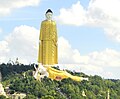
The major tourist attraction in Monywa is Thambuddhe Pagoda , a Buddhist temple with a huge stupa resembling Indonesia's Borobudur. It dates from 1303, although it was reconstructed in 1939. It is said to contain over 500,000 images of Buddha. Close by is the Maha Bodhi Tahtaung Laykyun Sekkya standing Buddha statue, the 3rd tallest statue in the world, at 115.82 metres (a total of 129.23 metres, including the pedestal). This is the focal point of a sprawling site filled with Buddha statues, bodhi trees, and pagodas, established by the Maha Bodhi Ta Htaung Sayadaw in the 1960s. It includes also a 95-metre long reclining Buddha statue.[17]

Another attraction is the Phowintaung cave complex across the Chindwin River, approximately 25 kilometres (16 mi) west of Monywa.

Nyaung-gan Bronze Age cemetery, dated to between 1,500 BCE and 500 BCE, in Budalin with bronze tools, ceramics and stone artifacts is 60 minutes travel on a narrow road north of Monywa.[18]

Very few tourists visit Monywa as its facilities are limited.

Education

[edit]
Technological University (Monywa)

The city is home to several higher education institutions:

  1. Monywa University
  2. Monywa Education College
  3. Monywa University of Economics
  4. Technological University, Monywa[19]
  5. Computer University, Monywa[20]

Healthcare

[edit]

Monywa has two public hospitals:

  • Monywa General Hospital
  • Monywa Women and Children Hospital

Politics

[edit]

The insurgent Burmese Communist Party (BCP) was centred in the Monywa area (west of the Chindwin River) for many years. The Myanmar military presence in Monywa remains heavy.[21]

Notable residents

[edit]
[edit]

Notes

[edit]
[edit]
Revisions and contributorsEdit on WikipediaRead on Wikipedia
from Grokipedia

Monywa is a city in the of , located on the eastern bank of the approximately 136 kilometers northwest of . It functions as a key commercial and transportation hub in central Myanmar, facilitating trade along the river and supporting regional agriculture and industry. Copper operations near the city contribute significantly to Myanmar's mineral production, with extraction beginning in the early 1980s. Monywa is also noted for its prominent Buddhist sites, including the statue near Khatakan Taung village, a 116-meter-tall standing figure that ranks among the world's tallest statues.

Geography and Environment

Location and Topography

Monywa lies in , , on the eastern bank of the , approximately 99 kilometers west-northwest of as measured by straight-line distance. The , a principal of River, positions the city as a key node in regional riverine transport, with annual runoff at Monywa averaging 4,750 cubic meters per second based on data from 1967 to 2009. The topography surrounding Monywa features flat alluvial plains formed by river sediments, supporting extensive including leaf cultivation and reliance on for . Within the urban area, many streets are lined with neem trees (), contributing to its local designation as "Neem City." Proximate to Monywa, the Letpadaung copper mine has been associated with environmental risks such as waterway and farmland destruction, with assessments indicating potential long-term impacts on surface and from acid and metals. The Chindwin River's flood-prone nature exacerbates these vulnerabilities; for instance, embankment leaks in July 2024 necessitated resident-led reinforcement using over 100,000 sandbags in prior events like 2015, highlighting recurrent inundation threats to low-lying areas.

Climate

Monywa experiences a characterized by high temperatures year-round, a pronounced , and a dry period influenced by the region's inland location along the . Annual average temperatures reach 27°C, with extremes ranging from a minimum of 14°C to maxima exceeding 40°C, rarely dipping below 12°C or surpassing 43°C based on historical station data. totals approximately 1,035 to 1,069 mm annually, concentrated almost entirely during the southwest from May to . The dry season spans November to April, featuring hot days with average highs of 30–35°C and minimal rainfall under 50 mm monthly, enabling agricultural activities like cultivation but straining for urban use. In contrast, the brings heavy downpours, with June to September accounting for over 80% of annual rainfall, including peaks of 200–300 mm per month; average highs drop slightly to 32–33°C amid high . This pattern heightens flood risks, as swells in the frequently inundate low-lying areas around Monywa, damaging crops such as and infrastructure; historical records indicate peak flood occurrences in July and August, contributing to 72% of basin-wide events since 1965. Recent meteorological observations point to shifts potentially linked to broader variability, including a shortening duration but intensified rainfall events, exacerbating flooding as noted in 's national assessments. Central stations, including those near Monywa, have recorded an upward trend in at rates up to 300 mm per in some periods, alongside increased extreme daily totals post-2000, heightening vulnerability for riverine communities and dry-season farming. Events like the 2024 Chindwin overflows underscore ongoing seasonal threats, with water levels rising several feet above norms in Monywa during peak flows.

History

Pre-Colonial and Founding

Monywa's origins trace to a small settlement known as Myinzaing, or "Swift Horse Village," located at the site's present position during the Kingdom period (c. 1044–1287 CE), when the area along the supported rudimentary riverine activity amid broader Pyu and early Burman migrations into upper Myanmar. Archaeological evidence from the indicates human activity dating back to the Pyu civilization (2nd century BCE–9th century CE), with the Chindwin's navigable waters enabling early trade in goods like jade and timber between inland highlands and the basin. Under the (1752–1885), the settlement evolved into a modest riverside , leveraging the Chindwin River's seasonal for inland commerce connecting Mandalay's emerging economic sphere to western frontiers, including routes toward and , distinct from coastal ports dominated by southern kingdoms. This development aligned with Konbaung efforts to consolidate control over upper Burma's dry zone, where riverine transport supported agricultural surpluses from Sagaing's fertile plains and extraction of forest resources. No formal founding charter exists, but the post's growth reflected pragmatic dynasty-wide priorities on internal trade networks over expansionist campaigns post-1760s. Buddhist traditions profoundly influenced the community's early structure, with pagoda foundations like Thanboddhay (constructed c. 1300 CE) serving as focal points for monastic organization and merit-making, embedding practices that predated Konbaung rule but persisted to define social cohesion amid trade fluctuations. These sites, often built on elevated terrain overlooking the river, underscored causal linkages between spiritual patronage and settlement stability, as royal and local donors sponsored expansions to legitimize authority in peripheral areas.

Colonial Era and Independence

Monywa was annexed by the as part of Upper Burma following the Third Anglo-Burmese War in November 1885, with formal incorporation into British India occurring on January 1, 1886. The town, situated on the —a major tributary of —was integrated into the colonial administrative framework as a key district center in the , where British authorities prioritized riverine transport for extracting timber and agricultural goods like and . Steam-powered flotillas, expanded after explorations in 1881, facilitated trade volumes that grew the local economy but exacerbated ethnic frictions through the importation of Indian merchants, clerks, and laborers, who dominated commerce and administration, fostering resentment among Burmese populations that persisted beyond colonial rule. In , Japanese forces captured Monywa in early 1942 during their invasion of , establishing it as a communications hub for the 33rd Infantry Division along the Chindwin. British-led Allied troops from the 1st Burma Division launched a on May 2, 1942, but were defeated after intense fighting, enabling Japanese consolidation until 1945. The occupation imposed forced labor, resource extraction, and supply disruptions, while Allied bombings and scorched-earth retreats further devastated the local agrarian economy, with river trade halting amid widespread and displacement affecting tens of thousands in the region. Burma achieved independence on January 4, 1948, but Monywa, as a regional administrative and logistical node in Division, grappled with the ensuing civil strife from insurgencies by the , , and other factions that fragmented central authority. By the early , rebel encirclements threatened the town, prompting the formation of —government-backed village defense units drawing on semi-mythical Bamar warrior lore—to counter communist guerrillas and secure supply lines, highlighting how colonial-era infrastructure vulnerabilities amplified post-independence security challenges in the Dry Zone. These dynamics underscored causal continuities from British divide-and-rule policies, which had unevenly developed river ports like Monywa while sidelining local capacities.

Post-Independence Development

Following Myanmar's independence on January 4, 1948, Monywa positioned itself as a regional commercial node, facilitating the transport and trade of agricultural goods from the fertile valley, including rice, beans, and sesame. Its proximity to the Ayeyarwady River and developing road networks supported steady economic activity amid national challenges like insurgencies and economic centralization. Under the "Burmese Way to Socialism" implemented after the 1962 military coup, state control over major industries and trade stifled private initiative nationwide, yet Monywa's local markets endured as essential for agrarian exchange in Sagaing Division, with limited expansion due to import substitution policies and isolationism. The 1970s saw modest infrastructure investments, such as extensions of motor roads from Pakokku to Monywa, aimed at integrating western Ayeyarwady regions into the national economy. The 1988 shift to a , prompted by the and subsequent junta reforms, permitted private trade and foreign investment, spurring Monywa's growth in commerce and small-scale processing industries tied to . Upgrades to the Sagaing-Monywa road and connections to enhanced logistics, driving increases and urban development; by the 2010s, Monywa's township exceeded 200,000, reflecting influxes from rural areas seeking trade opportunities. Monywa maintained greater stability than Myanmar's ethnic periphery, benefiting from Bamar-majority demographics and focus, though underlying tensions arose from resource extraction, notably the Letpadaungtaung copper mine operational since the 1990s, which displaced farmers and sparked protests over inadequate compensation and . These grievances highlighted disparities in benefit distribution from mining revenues, estimated at billions in exports, despite promises of local development.

Civil Conflict and Recent Developments

Following the military coup on February 1, 2021, Monywa became a focal point for widespread anti-junta protests, with thousands marching in the streets demanding the restoration of civilian rule and the release of detained leaders. responded with lethal force, including shootings and arrests, contributing to hundreds of protester deaths nationwide by mid-2021, though specific tallies for Monywa remain underreported amid restricted access. By late 2021, local resistance groups began forming People's Defense Forces (PDFs) in , including around Monywa, transitioning from unarmed demonstrations to armed confrontations against junta positions as protests faced escalating repression. In 2022, PDFs in conducted ambushes and assaults on junta outposts near Monywa, capturing several bases in amid coordinated operations with allied groups, which temporarily disrupted military supply lines but prompted retaliatory airstrikes and ground sweeps. Protests also targeted the nearby Letpadaung mine, with demonstrators in May 2023 accusing it of funneling revenues to junta coffers, leading to clashes that highlighted local grievances over resource extraction funding the conflict. Similar actions persisted into 2024, with hundreds rallying in against mine operations, resulting in arrests and underscoring the mine's role in sustaining military finances despite environmental and displacement concerns. From 2023 onward, intermittent PDF ambushes continued around Monywa, met by junta artillery barrages and arson attacks on villages, displacing thousands westward in September 2025 alone as counteroffensives intensified. Civilian casualties mounted from both sides, including 17 killed in a January 2025 junta airstrike on a Sagaing church and injuries from resistance operations, exacerbating economic disruptions like halted supplies in the region. In nearby Mingin Township, approximately 200 residents protested in September 2025 over the arrest of resistance affiliates, reflecting persistent local defiance amid over 3 million nationwide displacements since the coup.

Government and Politics

Administrative Status

Monywa functions as the de facto administrative capital of in , housing all major regional government offices, including the regional parliament, despite the 2008 designating as the formal capital. The city serves as the headquarters of , an administrative division in southern that encompasses both urban and rural areas. Monywa District, formerly known as Lower Chindwin District during the British colonial period, was reorganized post-independence in 1948 as part of Myanmar's divisional structure, with Monywa confirmed as its district seat. The district's jurisdictional boundaries include , which covers the urban core along the , as well as the rural townships of Ayadaw, Budalin, and Chaung-U, spanning agricultural lowlands and riverine areas. Following the 2021 military coup, the has maintained this hierarchical framework, with Monywa retaining its role in regional administration under junta oversight. During the Konbaung Dynasty (1752–1885), Monywa emerged as a significant settlement in the Chindwin Valley but lacked formal elevation to district or regional capital status, which was centered in nearby royal capitals like Sagaing and Ava; its administrative prominence solidified in the modern era through colonial and post-colonial reorganizations.

Local Governance and Capital Role

Monywa serves as the administrative capital of Sagaing Region, housing the regional government's offices that coordinate oversight of district-level services, including local taxation and public works. The Sagaing Region Government, based in Monywa, manages revenue collection through township-level general administration departments and allocates funds for infrastructure maintenance and development projects, with Monywa Township maintaining a distinct separation between urban municipal efforts and rural public initiatives to optimize resource distribution. In its capital capacity, Monywa facilitates regional coordination of and , sectors central to the area's , by implementing policies that prioritize farming enhancements, breeding, and market linkages to drive socio-economic growth. The regional administration in Monywa directs efforts such as support and services, leveraging its position to integrate district-level inputs into broader state-level . Prior to the February 2021 military coup, Region's governance incorporated limited elected elements through the regional (Hluttaw), where members influenced budget approvals and oversight, as seen in Monywa where parliamentary sign-off provided checks on local expenditures. Following the coup, the (SAC) replaced these structures with appointed administrators, embedding military personnel in key roles to enforce centralized directive over civilian functions, including taxation enforcement and public works prioritization.

Political Controversies and Resistance

Following the February 1, 2021, military coup in , Monywa witnessed early anti-junta protests, with demonstrators marching through the city on February 16, 2021, demanding an end to military rule. These peaceful actions escalated after opened fire on protesters in Monywa on March 3, 2021, killing several civilians in one of the coup's initial massacres. By mid-2021, protests in the , including Monywa, transitioned into armed resistance through the formation of local People's Defense Forces (PDFs), which conducted ambushes on junta convoys and reinforcements; for instance, on January 15, 2023, Monywa Township's Area 71 PDF ambushed regime soldiers traveling covertly, resulting in at least one junta death. The junta responded with raids on PDF camps, such as a June 7, 2023, operation in involving 80 soldiers that killed four resistance fighters and two civilians, alongside airstrikes and mass arrests to suppress operations. The Letpadaung Taung copper mine, located east of Monywa and operated by a Chinese state-owned , has fueled recurrent controversies over , forced evictions, and revenue flows to the junta. In 2013, protests erupted after razed monk-led camps and set fires during clashes with demonstrators opposing land seizures affecting tens of thousands, leading to a government commission criticized by locals for favoring corporate interests. Renewed demonstrations in 2023 and 2024, involving hundreds in Monywa , targeted the mine's operations for allegedly financing junta atrocities through royalties, amid reports of and inadequate compensation, though production resumed under protection. In 's Bamar-majority areas like Monywa, resistance has primarily involved ethnic Burman PDFs rather than longstanding minority insurgencies, though alliances with groups like the have enabled joint operations against junta positions. Documented violence includes junta-executed village burnings and civilian executions in Sagaing—over 80 excessive force incidents from February to July 2023—contrasted with PDF ambushes that occasionally ensnared non-combatants, contributing to mutual escalations without the ethnic separatist motives seen in border regions. These conflicts have displaced thousands locally in Sagaing, with nationwide junta crackdowns causing at least 1,400 civilian deaths by February 2022, rising to over 6,000 reported political killings by mid-2023, though resistance forces have captured junta outposts in the region, demonstrating tactical gains amid protracted guerrilla warfare.

Demographics

According to the 2014 Population and Housing , Monywa had a total of 372,095, with 207,489 residents (55.8%) classified as urban and the remainder rural. The township's overall population density stood at 540.1 persons per square kilometer, reflecting concentrated settlements proximate to the , which influences housing patterns through floodplain accessibility and transportation advantages. Prior to the 2021 military coup, demographic growth in Monywa's urban core was supported by net in-migration from rural , elevating the urban proportion within the from earlier baselines. This pattern aligned with broader regional , where Sagaing's urban share rose modestly amid internal movements toward commercial nodes like Monywa. The ensuing from the 2021 coup reversed these trends, prompting outflows from Monywa due to clashes and airstrikes in , which displaced over 1 million people regionally by mid-2023. Recent estimates place Monywa's urban at approximately 182,000 as of 2024, indicating stagnation or net decline from 2014 levels despite national projections for moderate growth elsewhere. The -level figure has reportedly fallen to 238,394 by 2024, yielding an annual change rate of -4.2% since 2014, attributable to conflict-induced migration and incomplete coverage in contested areas. Urban density remains elevated near the riverbank, sustaining linear settlement corridors while peripheral rural zones experience depopulation.

Ethnic and Religious Composition

Monywa's ethnic composition is overwhelmingly Bamar (Burman), aligning with the Region's demographic profile where Bamar form the clear majority, supplemented by smaller proportions of Shan and other groups such as Naga, Kuki, and Kadu. The city ranks as one of Myanmar's most ethnically homogeneous urban areas, with minimal diversity beyond these core communities and limited presence of or other minorities typically found in peripheral hill regions. Religiously, Buddhism dominates, comprising approximately 92% of Region's adherents and shaping Monywa's social fabric through pervasive monastic influence and communal practices. account for around 6.5% regionally, primarily among ethnic minorities like or Bayingyi Catholics, while (1.1%) and (0.1%) represent negligible fractions, often tied to historical trading enclaves. British colonial policies (1824–1948) facilitated an influx of Indian laborers and merchants into , peaking at over 2 million by 1931 nationally, though concentrations were higher in ports like than inland hubs such as Monywa; post-independence nationalizations and restrictions under the 1982 law reduced these communities to trace levels today.

Economy

Agricultural and Commercial Base

Monywa's agricultural economy centers on the cultivation of , pulses, and oilseeds, supported by the alluvial soils of the floodplains and the broader Central Dry Zone of . Key crops include paddy, with planting targets exceeding 751,000 acres across Monywa and adjacent townships such as Chaung-U, Butalin, and Ayadaw in recent seasons. Pulses like (Cicer arietinum), (Cajanus cajan), green gram (Vigna radiata), (Phaseolus lunatus), and lablab bean (Lablab purpureus) dominate upland farming, reflecting the region's suitability for legume and oilseed production amid variable rainfall. Oilseeds, particularly , groundnut, sunflower, and , are also prominent, with Monywa District allocating 139,701 acres for winter oilseeds and completing 421 acres of summer in 2025. The 's flood-prone lowlands enable paddy farming during wet seasons but expose crops to inundation risks, as seen in recurrent flooding events. As a regional collection and distribution hub, Monywa aggregates agricultural output from Sagaing's rural areas for and onward , functioning as a for pulses, oilseeds, and . Local traders handle bulk from farmers, channeling produce through district-level exchanges to urban centers like via road and routes, historically vital for bulk transport in the pre-rail era. Neem-derived products and other minor commodities supplement core staples in local markets, though pulses and oilseeds form the export-oriented backbone. initiatives, including distribution and Good Agricultural Practices certification for over 2,000 acres of diverse crops by 2022, have aimed to boost yields and quality. Prior to the 2021 military coup, agricultural accelerated regionally from 2011 onward, enhancing productivity in , pulses, and oilseeds amid economic reforms; saw notable yield gains, such as 34% increases in monsoon paddy. Post-coup has since curtailed these activities, with disrupted supply chains, input shortages, and violence converting trade warehouses into refugee shelters, stalling commerce in this former economic vibrant center.

Industrial Activities and Challenges

The Letpadaung copper mine, situated approximately 5 kilometers west of Monywa, represents the region's dominant industrial operation, managed by Myanmar Wanbao Mining Copper Limited, a subsidiary of China's Wanbao Mining. As one of Myanmar's largest copper deposits, the open-pit project extracts significant ore volumes, contributing to national mineral output, though precise production figures post-2021 remain opaque due to restricted reporting amid conflict. The mine employs thousands locally, providing a key non-agricultural revenue stream, but operations have drawn scrutiny for alleged environmental degradation, including water and soil contamination from tailings, as documented in investigations of the broader Monywa copper complex. Protests against the mine have persisted, fueled by expropriations without adequate compensation and force violence; clashes in 2012 injured over 100 demonstrators, while June 2024 rallies by hundreds accused the project of channeling revenues—estimated in prior years at tens of millions annually—to sustain the through partnerships with military-linked firms. A 2013 contract revision increased Myanmar's profit share to 51 percent, yet local communities report minimal benefits amid ongoing disputes. Beyond mining, Monywa hosts limited small-scale , such as basic textiles and units tied to local commerce, but these sectors have contracted sharply since the February 2021 coup due to disruptions and kyat depreciation, with the currency's black-market value falling over 300 percent to 3,900 per USD by mid-2023. Industrial challenges intensified by Region's include elevated poverty rates—reversing pre-coup declines—and mass out-migration of workers seeking stability elsewhere, exacerbating labor shortages. Junta-imposed further hinder imports of machinery and inputs, stalling expansion while and real wage erosion compound economic isolation.

Infrastructure and Services

Transportation Networks

Monywa's primary road connection is the , spanning approximately 136 kilometers northwest from , serving as the main access route for passengers and goods. Bus services dominate passenger transport, with frequent departures from 's bus stations taking about 2.5 hours under normal conditions, operated by local companies using mini-buses and express coaches. The on Bogyoke Road handles intercity routes, including connections to via , though travel times can extend due to traffic and seasonal road conditions. Rail connectivity is provided by a from the Mandalay-Budalin railway, with Monywa Railway Station located centrally in the town, facilitating limited and freight services as part of Myanmar's broader 6,207 km network. Trains operate irregularly on this line, connecting to the national system but with low capacity compared to road options. The supports vital inland waterway for goods and s, with routes extending from Monywa northward to Hkamti (over 1,000 km) using powered and non-powered vessels managed by the Inland Water Transport authority. services link Monywa to upstream towns like Homalin and Khamti, carrying agricultural products and enabling year-round operations for vessels with shallow drafts, though flooding disrupts navigation and increases risks. Private operators handle much of the ferry traffic, complementing road limitations during rainy seasons. Since the 2021 military coup, transportation networks have experienced significant disruptions from armed conflict between junta forces and resistance groups, including ambushes on road convoys, river blockades, and military flotillas securing Chindwin passages, which have delayed trade flows and heightened security risks. Junta plans to restrict express cargo boats on the Chindwin have further threatened goods movement to upper , exacerbating vulnerabilities in river-dependent logistics. These issues, compounded by airstrikes and village raids along routes, have led to civilian displacements and reduced reliability of both road and river links.

Healthcare Facilities

Monywa General Hospital serves as the primary public healthcare facility in Monywa Township, , with a 500-bed capacity and providing basic emergency, outpatient, , , and inpatient services to residents and surrounding areas. A new five-storey extension, including modern elevators and specialized departments, was commissioned in September 2022 to expand capacity amid regional demands. Other facilities include the private Monywa Private Hospital, Shwe Taung Oo Specialist Clinic for targeted care, Monywa TB Center addressing , and Shweyatu Tipitaka Cakkhupala Hospital, alongside reproductive health services at the Myanmar center on Saitan Road. Pre-coup, the region faced shortages in specialist personnel, with general surgeons handling routine procedures at facilities like Monywa General Hospital due to limited advanced training availability. The 2021 military coup exacerbated these issues through widespread disruptions, including targeted attacks on health workers—at least 20 killed in between March 2021 and July 2024 via airstrikes, ambushes, and direct violence—and closures or destruction of clinics, reducing access to routine and emergency care. Military occupations and raids on hospitals further strained operations, with health staff reporting fear-induced service reductions and supply shortages nationwide, including in Sagaing. Public health challenges in Monywa and include persistent risks of and , intensified by displacements from 2021 onward, which have displaced over a million in the region and overwhelmed remaining facilities with cases of undernutrition and infectious diseases. Junta restrictions on humanitarian access have limited formal aid delivery, forcing reliance on informal networks in resistance-held areas for basic medical support, while a March 2025 damaged additional infrastructure across , compounding capacity issues with collapsed buildings and disrupted supplies. Overall, these factors have led to diminished specialist availability and heightened vulnerability to treatable conditions, with empirical incident data indicating bidirectional violence but disproportionate impacts on access in contested zones.

Education System

Monywa's education system follows Myanmar's national structure, with compulsory for five years starting at age five, followed by middle and secondary levels, all primarily in the as the . The curriculum emphasizes core subjects including Myanmar language, English, , , , and moral education, as outlined in the national framework. Local institutions provide primary and secondary schooling, though specific enrollment data for Monywa is limited; nationally, primary gross enrollment exceeded 100% pre-2021 due to over-age students, but has declined amid post-coup disruptions. Higher education in Monywa includes , a coeducational institution offering undergraduate programs, and , established in 1998 and upgraded in 2014 to focus on economics and business studies. Specialized training occurs at Monywa Education College for teacher preparation and Technological University, Monywa, founded in 1986, which provides engineering and technical degrees. Monywa Government Technical College offers vocational programs, including potential agricultural-related skills aligned with the region's , though dedicated agricultural universities are located elsewhere in . The 2021 military coup has profoundly impacted in , where Monywa is located, with intense fighting leading to widespread school closures, airstrikes on at least 170 educational sites nationwide by mid-2024, and severe infrastructure damage in . Approximately 30% of teachers were dismissed for joining the Movement, exacerbating staffing shortages and contributing to an academic brain drain as students and faculty flee instability or face risks. In March 2021, security forces raided Monywa University to deter anti-coup protests, signaling early suppression of educational dissent under junta control. The military regime's influence extends to curriculum oversight, prioritizing national unity narratives while alternative networks have emerged in resistance areas, though their reach in urban Monywa remains constrained by ongoing conflict.

Culture and Heritage

Cultural Traditions

Monywa's cultural traditions reflect the broader Burmese emphasis on Buddhism, where communal rituals and seasonal observances foster social cohesion and spiritual renewal. Annual festivals dominate the calendar, blending religious piety with vibrant public celebrations that draw participation from across the city's diverse population. These events, often tied to the lunar , emphasize merit-making through offerings, processions, and shared feasts, underscoring the role of in daily life. The water festival, held from April 13 to 16, marks the Burmese New Year with rituals symbolizing purification and the expulsion of misfortune. In Monywa, locals engage in water-splashing games, musical performances, and organized walking parades featuring colorful umbrellas along roads like Kanthaya Bogyoke, promoting community interaction amid the festivities. This tradition, observed nationwide, adapts locally to include riverbank gatherings influenced by the nearby Chindwin, where participants draw water for symbolic cleansing. Pagoda festivals, peaking in the Tazaungmone month of , feature traditional dances, songs, plays, and elaborate food stalls, serving as key venues for cultural expression and family reunions. These gatherings, held at various local shrines, involve merit accumulation through almsgiving and performances that preserve oral histories and , even as political instability disrupts broader societal functions. Reports from indicate such events continue despite Myanmar's post-2021 challenges, highlighting the endurance of these practices in maintaining communal identity. Culinary customs leverage the Chindwin River's resources, with forming the basis of staples like curries and fermented dishes, often prepared communally during . Street vendors in Monywa's markets sell these alongside seasonal fruits and spices, reflecting adaptive resource use in a riverside . Local handicrafts, including woven textiles, appear in festival markets, though production remains small-scale and tied to traditions rather than large industries.

Religious Sites and Attractions

Thanboddhay Pagoda, located in Monywa, Sagaing Region, is a prominent complex originally founded in the early and extensively reconstructed between 1939 and 1952. The site features over 500,000 small images encased in niches across its multi-tiered structure, which draws stylistic inspiration from Indonesia's Temple. The central rises prominently, surrounded by corridors lined with these miniature statues, making it a key draw for visitors interested in Myanmar's . Approximately 10 kilometers south of Monywa, the Maha Bodhi Tahtaung complex atop a hill hosts monumental statues, including a 116-meter-tall standing figure, the third tallest in the world, and a 91-meter-long accessible via an internal chamber. Construction of these statues began in the late under the direction of local monastic leaders, with an additional seated statue planned to be among the largest globally, though its completion remains ongoing. The site's elevated position offers panoramic views, enhancing its appeal as a pilgrimage and sightseeing destination. About 25 kilometers northwest of Monywa, the Hpo Win Daung (Phowintaung) Caves form a network of approximately 947 rock-cut chambers developed from the 14th to 18th centuries, containing ancient images, murals, and relics preserved within natural formations. Access to the caves typically involves boat crossings over the followed by climbs, often facilitated by local tuk-tuks, revealing intricate wall paintings depicting and historical scenes. East of Monywa, roughly 32 kilometers away, Shwe Gu Ni Pagoda dates to the and enshrines a 33-meter-high seated statue adorned with layers of applied by devotees. The pagoda's architecture reflects medieval Burmese styles, with the gilded image serving as a focal point for rituals and offerings. Prior to the military coup and ensuing civil war, these sites attracted regional tourists via organized day trips from , contributing to Monywa's reputation for diverse Buddhist heritage. Ongoing armed conflicts in have since restricted access, heightened security risks, and curtailed visitation, with many areas advisories urging avoidance due to active hostilities.

Notable Figures

Ledi Sayadaw (1846–1923), born U Ñaṇadhaja in Saing-pyin village, Dipeyin Township (now part of Monywa District), emerged as one of the most influential Buddhist scholars in modern Burmese history. Ordained at age 20, he mastered and Abhidhamma texts early, founding in Monywa in 1887 to propagate scriptural study and . His campaigns against British colonial influences, including petitions for protection under Buddhist precepts, mobilized lay practitioners, while his revival of vipassana democratized insight practice beyond monastic circles, authoring over 100 works on doctrine. This emphasis on personal ethical discipline and scriptural literacy countered perceived declines in piety during colonial rule. Tin Hlaing (born 1941), originating from Thakutpinle village in Monywa District, represents a bridge between rural Burmese heritage and modern intellectual pursuits as a , translator, and . Educated in physics at University, he advanced Myanmar's scientific infrastructure as founder and inaugural director general of the , overseeing early nuclear research and development initiatives in the post-independence era. His literary output, drawing from rural life experiences, includes essays and translations that explore cultural and scientific intersections, contributing to Burmese amid evolving . The Venerable Mohnyin Sayadaw, a direct disciple of , gained prominence through his visionary projects in Monywa, notably commissioning the Thanboddhay Pagoda starting June 20, 1939, and completing it on March 2, 1952. This complex enshrines over 5 million images in niches, symbolizing devotion to the Tipitaka, with his effigy preserved onsite to honor his role in fostering mass-scale religious art and centers. His lineage preserved Ledi's vipassana tradition, establishing monasteries that emphasized rigorous practice amid 20th-century upheavals.

References

Add your contribution
Related Hubs
User Avatar
No comments yet.