

Community hub
Recent from talks
Contribute something
Nothing was collected or created yet.
Slunj
View on Wikipedia
Key Information


Slunj is a town in the mountainous part of Central Croatia, located along the important North-South route to the Adriatic Sea between Karlovac and Plitvice Lakes National Park, on the meeting of the rivers Korana and Slunjčica. Slunj has a population of 1,674, with a total of 5,076 people in the municipality (2011)[3] and is the cultural and social center of the region of Kordun in the vicinity to Bosnia and Herzegovina. Administratively, the town is part of Karlovac County. Slunj is an underdeveloped municipality which is statistically classified as part of the First Category Area of Special State Concern by the Government of Croatia.[4]
Climate
[edit]Since records began in 1955, the highest temperature recorded at the local weather station was 40.0 °C (104.0 °F), on 4 August 2017.[5] The coldest temperature was −24.0 °C (−11.2 °F), on 16 February 1956.[6]
History
[edit]An old fortification of the Frankopans, built during the wars against the Turks, Slovin was first mentioned in the 12th century. The old fort was property of the Frankopan (Hungarian Frangepán) family since the 15th century, joined by an old Franciscan monastery from the same period. Later, this town has been called Slunj. In the 16th century the town was ravaged by the Ottoman wars and turned into a military outpost of the Croatian Military Frontier, but by the end of the 17th century the settlement was rebuilt into the Slunj as it exists today. The castle has been developed to a fortress and served as headquarters for the commanding general of this area (see Stari grad Slunj). After the Treaty of Sistova in 1791 people increasingly began to re-settle in this area.
The town of Slunj was first mentioned in a written document by the chronicler Johann Weikhard von Valvasor who reported about the fortified town of Slunj, a bridge and a mill in 1689. The first illustration of the mills of Rastoke dates back from 1789. It was a copper engraving that has been added to a description by Belsazar Hacquet. At the end of the 19th century, Stjepan Širola wrote the following about this place: "The surroundings of Slunj are downright romantic […]. They are crowned by the magnificent waterfalls of the Slunjčica river by which even not outspoken nature lovers will be captivated. Indeed, Slunj with its romantic surroundings and the silver waterfalls of the Slunjčica represent a true nature gem astonishing even to foreigners."
During the short French governance period from 1809 until 1813, Slunj encountered an economic boom as streets, storage facilities and mills were built and as vineyards and mulberry trees were planted. At this point of time, the Croatian language has become official language of the country. The residence of the former governor general of the French Illyrian Provinces, marshal Auguste de Marmont, still exists.
Until 1918, Slunj (named SZLUIN[7]) was part of the Austrian monarchy (Kingdom of Croatia-Slavonia, Modruš-Rijeka County, after the compromise of 1867), in the Croatian Military Frontier.[8] It was administered by the SZLUINER Grenz-Infanterie-Regiment N°IV before 1881. Slunj became a district capital in the Modruš-Rijeka County in the Kingdom.
WWII
[edit]On 12 April 1941, a group of 700 soldiers of the Royal Yugoslav Army launched an attack on Slunj from Primišlje in an attempt to penetrate further towards Bosnia, but after 6 hours the attack on Slunj failed. Wehrmacht forces entered Slunj at the behest of the Ustaša administration of Slunj in the evening, while the Luftwaffe bombed Yugoslav positions. A large number of soldiers were captured, and of those about 30 officers and 100 soldiers pledged allegiance to the NDH. Throughout that same day, a large number of Croat former Yugoslav soldiers from Bihać and Korenica had been making the same pledge. German soldiers returned to Karlovac that evening with 2 captive Yugoslav generals.[9]: 63
On the Gregorian Easter Sunday of 13 April 1941 at around 9:00, German tanks, trucks and motorcycles, together with Italian bicycle infantry, passed through Slunj, well-received by most of its Croat residents but resented by most of its Serb residents. This became a frequent sight for a week. The German soldiers rarely stopped, with the exception of one unit from France on whom night fell, so they spent the night. The Italian soldiers often stopped frequently in Slunj in mid-April, but gained a poor reputation because of chicken thieving and not paying innkeepers. The Invasion of Yugoslavia only lasted 2–3 days in and around Slunj.[9]: 63, 64
On 22 August 1941, all of Slunj's kotar and općina level members of the HSS formally joined the Ustaša movement. This followed an 8 June 1941 meeting between NDH Minister of People's Economy Lovro Sušić and the representatives of kotar level organs of the HSS.[9]: 65
Initially in April 1941, the Royal Italian Army would take captured Serbs to POW camps in Italy. But on 7 May 1941, the same day as the Blagaj massacre, an Italian cavalry regiment arrived in Slunj and freed all Serbian captives there. On the 10th, Italian Carabinieri arrived in Slunj and disarmed the Croats in Slunj, Rakovica and Drežnik Grad. Twenty Italian financial servants arrived to act as financial overseers in Slunj kotar. Most of this was in the context of obtaining better territorial concessions in the upcoming delineation of their border with the NDH. This came with the Treaties of Rome on the 18th, in which the Italians obtained a stronger position within the Italian occupation zone but no annexable territory as far inland as Slunj. The Italian Army left Slunj on June 7.[9]: 67
On 1 July 1941, Ante Pavelić founded the Velika župa Modruš with its seat in Ogulin, by merging Ogulin with Slunj, Vrbovsko and Delnice.[10]: 350
With the withdrawal of the Italians, the chances of a successful Serb rebellion increased. Shortly after the Drvar uprising, Božidar Cerovski, director of the Directorate of the Ustaša Police, arrived in Slunj, on the evening of 29 July 1941, along with an undetermined number of Ustaše from Zagreb for the removal of "undesirable elements". In the morning of the 30th, they broke up into several groups and walked through Serb inhabitted settlements with lists of such individuals, detaining them and transporting them to Oštarski Stanovi, where they were executed on the order of Cerovski.[9]: 69, 70
In the summer and autumn of 1941, many of the Serbs from the environs of Cazin and Velika Kladuša fled to Slunj to convert to Catholicism, in order to avoid conversion to Islam.[9]: 67, 68
Beginning on 19 June 1942, the Battle of Tržić took place between Kamenica and Tržić Tounjski. An army of Partisans attacked Tržić Tounjski, with the goal of destroying the bridge and disarming the Croatian forces in Tržić. The bridge was guarded by the 3rd Regiment of the Second Domobran Division. Battles continued with 6 waves of Domobran attacks until the 23rd, when the Partisan army took Tržić and captured the survivors. Across the river, the Domobrani of Primišlje retreated to Slunj.[11]
SFRY
[edit]The Cazin uprising of 1950, an armed anti-state rebellion of peasants, which mostly affected the Bosnian towns Cazin and Velika Kladuša, also affected Slunj to a lesser extent. All of the cities were a part of Communist Yugoslavia at the time.[12] Peasants revolted against the forced collectivization and collective farms by the Yugoslav government on the farmers of its country. Following a drought in 1949, the peasants of Yugoslavia were unable to meet unrealistic quotas set by their government and were punished. The revolt that followed the drought resulted in the killings and persecution of those who organized the uprising, but also many innocent civilians.[13][14] It was the only peasant rebellion in the history of Cold War Europe.[15]

In 1963, the Austrian writer Heimito von Doderer published the novel The Waterfalls of Slunj (German: Die Wasserfälle von Slunj) which features a climactic sequence set in this locality.[16] During the 20th century scientific research studies were carried out in the Slunj area and particularly its Rastoke district. During the 19th century and at the beginning of the 20th century Rastoke has been the center of social life in this region. With the development of the electric mill and massive emigration after the Second World War the economic significance of the mills in Rastoke has declined drastically.
Places of interest
[edit]Slunj is famous for its little waterfalls and the well-preserved corn mills (dating back to the 18th century) in the picturesque lower part of the town, called Rastoke (referring to the branching of the rivers). At Slunj, the Slunjčica river (also called “Slušnica“ by local people) flows over several waterfalls and cascades into the Korana river. Here is also the location of the 22 water mills of Rastoke.
Demographics
[edit]In 1895, the obćina of Slunj, with an area of 129 square kilometres (50 sq mi), belonged to the kotar of Slunj (Slunj court and electoral district) in the županija of Modruš-Rieka (Ogulin court and financial board). There were 1322 houses, with a population of 8847. Its 30 villages and 11 hamlets were divided for taxation purposes into 8 porezne obćine, under the Slunj office. In the 846 square kilometres (327 sq mi) Slunj kotar, there were a total of 6493 houses, with a population of 44,338. Its 92 villages and 150 hamlets were divided into 38 porezne obćine. The kotar had no statistical markets. Slunj kotar was divided into 6 općine. Besides itself: Drežnik, Primišlje, Rakovica, Vališ Selo, Veljun.[17]: iv, v
In 1910, the court of Slunj encompassed an area of 846 square kilometres (327 sq mi), with a population of 46,360. Slunj had its own cadastral jurisdiction, but its business court was in Ogulin.[18]: xxxii
As of 2011, most of Slunj's population is Croatian (87.9%) followed by Serbs (10.5%) and a small number of other ethnic groups.[19]
| population | 19430 | 19412 | 18110 | 20498 | 20724 | 21035 | 18749 | 21256 | 17004 | 16518 | 15798 | 13629 | 11799 | 10096 | 6096 | 5076 | 4224 |
| 1857 | 1869 | 1880 | 1890 | 1900 | 1910 | 1921 | 1931 | 1948 | 1953 | 1961 | 1971 | 1981 | 1991 | 2001 | 2011 | 2021 |
Settlements
[edit]The settlements in the Town of Slunj are (as of 2021):[20][21]
- Arapovac, population 1

- Bandino Selo, population 1
- Blagaj, population 24
- Bukovac Perjasički, population 1
- Crno Vrelo, population 6
- Cvijanović Brdo, population 0
- Cvitović, population 234
- Čamerovac, population 34
- Donja Glina, population 15
- Donja Visočka, population 4
- Donje Primišlje, population 22
- Donje Taborište, population 181
- Donji Cerovac, population 116
- Donji Furjan, population 39
- Donji Kremen, population 42
- Donji Lađevac, population 34
- Donji Nikšić, population 171
- Donji Poloj, population 8
- Donji Popovac, population 12
- Dubrave, population 6
- Glinsko Vrelo, population 39
- Gornja Glina, population 106
- Gornja Visočka, population 5
- Gornje Primišlje, population 7
- Gornje Taborište, population 205
- Gornji Cerovac, population 83
- Gornji Furjan, population 57
- Gornji Kremen, population 40
- Gornji Lađevac, population 45
- Gornji Nikšić, population 49

- Gornji Popovac, population 146
- Grobnik, population 10
- Jame, population 21
- Klanac Perjasički, population 5
- Kosa, population 10
- Kosijer Selo, population 4
- Kutanja, population 0
- Kuzma Perjasička, population 4
- Lađevačko Selište, population 6
- Lapovac, population 6
- Lumbardenik, population 132
- Mali Vuković, population 74
- Marindolsko Brdo, population 49
- Miljevac, population 10

- Mjesto Primišlje, population 39
- Novo Selo, population 52
- Pavlovac, population 19
- Podmelnica, population 155
- Polje, population 28
- Rabinja, population 0
- Rastoke, population 46
- Salopek Luke, population 9
- Sastavak, population 10
- Slunj, population 1576
- Slunjčica, population 3
- Snos, population 4
- Sparednjak, population 2
- Stojmerić, population 1
- Šlivnjak, population 12
- Točak, population 57
- Tržić Primišljanski, population 9
- Veljun, population 90
- Veljunska Glina, population 5
- Veljunski Ponorac, population 11
- Videkić Selo, population 14
- Zapoljak, population 1
- Zečev Varoš, population 17
Sport
[edit]Football
[edit]Although Slunj is very small, it has many sport clubs. Most famous are the football club NK Slunj and MNK Drenak. There are two football fields in Slunj. One is situated in the center of Slunj and popularly called Gradsko igralište (Town field) and the other is Zubac, which is the official turf of NK Slunj.
Koranski susreti
[edit]On the last day of "Dani grada Slunja" (festivity called Days of the city of Slunj), which usually takes place at the beginning of August, games are organized on main swimming area on the river Korana. Participating teams compete in many games like swimming and snorkeling and many other.
Infrastructure
[edit]In 1913, there were 7 gendarmeries in Slunj kotar: Cetin-grad, Gornja Močila, Nova Kršlja, Primišlje, Rakovica, Slunj and Veljun.[22]
Notable people
[edit]- Milan Neralić, fencer and winner of the Bronze Medal at the 1900 Summer Olympics
Acknowledgements
[edit]Twin towns
[edit] Castel San Giovanni, Italy
 Grude, Bosnia and Herzegovina
 Mississauga, Canada
Gallery
[edit]-
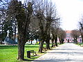 Park in the town center
 -
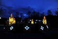 Christmas decorations in Slunj
 -
 Houses in Rastoke
 -
 Korana Bridge
 -
 Warehouse from Napoleonic times
 -
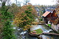 View of Rastoke
 -
 In front of the "Buk" department store.
 -
 Brothers Radić Street
 -
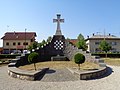 Memorial to fallen defenders and civil victims of the Croatian War of Independence


.JPG)


References
[edit]- ^ Register of spatial units of the State Geodetic Administration of the Republic of Croatia. Wikidata Q119585703.
- ^ "Population by Age and Sex, by Settlements" (xlsx). Census of Population, Households and Dwellings in 2021. Zagreb: Croatian Bureau of Statistics. 2022.
- ^ "Population by Age and Sex, by Settlements, 2011 Census: Slunj". Census of Population, Households and Dwellings 2011. Zagreb: Croatian Bureau of Statistics. December 2012.
- ^ Lovrinčević, Željko; Davor, Mikulić; Budak, Jelena (June 2004). "AREAS OF SPECIAL STATE CONCERN IN CROATIA- REGIONAL DEVELOPMENT DIFFERENCES AND THE DEMOGRAPHIC AND EDUCATIONAL CHARACTERISTICS". Ekonomski pregled, Vol.55 No.5-6. Retrieved 25 August 2018.
- ^ DHMZ (2022-07-19). "Najviše izmjerene temperature zraka u Hrvatskoj za razdoblje od kada postoje mjerenja". Državni hidrometeorološki zavod.
- ^ DHMZ (2022-01-21). "Najniže izmjerene temperature zraka u Hrvatskoj za razdoblje od kada postoje mjerenja". Državni hidrometeorološki zavod.
- ^ Name of the Austrian post-office opened in 1864.
- ^ Handbook of Austria and Lombardy-Venetia Cancellations on the Postage Stamp Issues 1850-1864, by Edwin MUELLER, 1961.
- ^ a b c d e f Prša, Želimir (2022-05-15). "Općine Rakovica i Drežnik Grad u Drugom svjetskom ratu (1941.- 1945.)". Podplješivički graničari. pp. 51–90. ISSN 2459-9395.
- ^ Škiljan, Filip (2011-12-01). "Teror ustaškog režima nad srpskim stanovništvom na području kotareva Vrbovsko, Delnice i Ogulin u proljeće i ljeto 1941. godine" [Terror of the Ustasha Regime against the Serbian Population in the Territory of the Vrbovsko, Delnice and Ogulin Districts in the Spring and Summer 1941]. Radovi Zavoda za hrvatsku povijest Filozofskoga fakulteta Sveučilišta u Zagrebu (in Croatian). 43 (1): 343–372. eISSN 1849-0344.
- ^ Trgo 1964, p. 313,328.
- ^ "CAZINSKA BUNA 1950: Danas se navršavaju 62 godine od ustanka u Krajini". Cazin. 6 May 2012. Archived from the original on 9 June 2012. Retrieved 11 February 2014.
- ^ "Klanjana kolektivna dženaza žrtvama Cazinske bune iz 1950. godine". Haber. 11 May 2012. Archived from the original on 22 February 2014. Retrieved 11 February 2014.
- ^ "Vera Kržišnik Bukić i Cazinska buna". Radio Sarajevo. 4 May 2012. Archived from the original on 22 February 2014. Retrieved 11 February 2014.
- ^ Mueller, Andrew (2010). Rock and Hard Places: Travels to Backstages, Frontlines and Assorted Sideshows. ISBN 9781593763794. Retrieved 11 February 2014.[permanent dead link]
- ^ Doderer Gesellschaft. Heimito von Doderer. Die Wasserfälle von Slunj.
- ^ Kraljevski zemaljski statistički ured (1895). "Glavni pregled područja županija, upravnih kotara i obćina, sudbenih stolova, sudbenih kotara, financijalnih ravnateljstva, poreznih ureda i izbornih kotara". Političko i sudbeno razdieljenje kralj. Hrvatske i Slavonije i Repertorij prebivališta po stanju od 31. svibnja 1895. Zagreb: Kraljevska hrvatsko-slavonsko-dalmatinska zemaljska vlada. pp. I–XXVII.
- ^ Kraljevski zemaljski statistički ured (May 1913). "Sudbeno razdjeljenje Kraljevina Hrvatske i Slavonije". Političko i sudbeno razdjeljenje i Repertorij prebivališta Kraljevina Hrvatske i Slavonije po stanju od 1. siječnja 1913. Zagreb: Kraljevska hrvatsko-slavonsko-dalmatinska zemaljska vlada, 🖶 Kraljevska zemaljska tiskara. pp. XXXI–XXXIII.
- ^ "Population by Ethnicity, by Towns/Municipalities, 2011 Census: County of Karlovac". Census of Population, Households and Dwellings 2011. Zagreb: Croatian Bureau of Statistics. December 2012.
- ^ "Population by Age and Sex, by Settlements" (xlsx). Census of Population, Households and Dwellings in 2021. Zagreb: Croatian Bureau of Statistics. 2022.
- ^ Cite error: The named reference
census2021was invoked but never defined (see the help page). - ^ Kraljevski zemaljski statistički ured (May 1913). "Razmještaj Kr. oružništva u Kraljevinama Hrvatskoj i Slavoniji". Političko i sudbeno razdjeljenje i Repertorij prebivališta Kraljevina Hrvatske i Slavonije po stanju od 1. siječnja 1913. Zagreb: Kraljevska hrvatsko-slavonsko-dalmatinska zemaljska vlada, 🖶 Kraljevska zemaljska tiskara. pp. XXXIV–XXXV.
- ^ "World recognition for the Croatian town of Slunj". croatiaweek.com. Croatia Week. 23 October 2023. Retrieved 23 October 2023.
Bibliography
[edit]- Trgo, Fabijan, ed. (1964). Zbornik dokumenata i podataka o Narodno-oslobodilačkom ratu Jugoslovenskih naroda. Vol. V, 32.
External links
[edit]- Official website
- Slunj Tourist Board
- Cultural Tourism in Croatia. Church of the Holy Trinity in Slunj. (Croatian)
Subdivisions of Karlovac County | ||
|---|---|---|
| Cities and towns |  | |
| Municipalities | ||
| International | |
|---|---|
| National | |
| Other | |
Slunj
View on GrokipediaGeography
Location and Physical Features
Slunj is situated in the mountainous region of central Croatia, within Karlovac County, at the confluence of the Korana and Slunjčica rivers.[4] The town lies approximately 50 kilometers southeast of Karlovac, along the primary north-south route connecting Zagreb to Zadar via Plitvice Lakes National Park.[4] Its geographic coordinates are 45.115° N latitude and 15.585° E longitude.[5] The municipality of Slunj covers an area of 392.54 square kilometers and encompasses 67 settlements.[6] The terrain is predominantly hilly and mountainous, characteristic of the Kordun region. Slunj's elevation averages 271 meters above sea level.[7] The Slunjčica River, flowing through the area, measures 64 kilometers in length and is marked by 93 travertine barriers, numerous waterfalls, and cascades, especially prominent in the Rastoke district.[8] Rastoke features a unique landscape shaped by the Korana, Slunjčica, and Plitvica rivers, creating a series of small waterfalls and travertine formations.[9]Climate
Slunj features a temperate oceanic climate (Köppen Cfb), marked by mild winters, warm summers, and relatively even precipitation distribution year-round.[10] Average annual temperatures hover around 10–12°C, with seasonal highs reaching above 25°C in summer and dropping below 5°C in winter.[5] The growing season spans approximately 206 days from early April to late October.[5] Monthly temperature averages, based on historical data from 1980–2016, show July and August as the warmest months, while January is the coldest:| Month | Average High (°C) | Average Low (°C) |
|---|---|---|
| January | 3.4 | -2.6 |
| February | 4.4 | -2.2 |
| March | 9.6 | 1.6 |
| April | 15.1 | 5.2 |
| May | 18.3 | 7.8 |
| June | 23.2 | 11.3 |
| July | 25.7 | 13.2 |
| August | 26.3 | 13.3 |
| September | 20.2 | 9.8 |
| October | 14.9 | 6.5 |
| November | 9.9 | 3.6 |
| December | 5.1 | -0.9 |
History
Early and Medieval Periods
The region encompassing modern Slunj shows evidence of human settlement dating back to prehistoric times, though specific archaeological findings attributable to the site itself remain limited and unverified in primary records prior to the medieval era.[12] The first documented reference to Slunj, then known as Slovin or Sluin, appears in 1322, when King Charles Robert of Hungary and Croatia granted the fortified settlement and its surrounding properties to noble benefactors as part of feudal allocations amid consolidation of royal authority in the region.[13] The town's fortifications, including an initial fortress overlooking the Slunjčica River, were constructed or substantially expanded around 1323, likely as a defensive measure against regional instability during the late high medieval period.[4] By the 15th century, Slunj had become a possession of the Frankopan family, a prominent Croatian noble lineage that fortified the site further to counter emerging threats from Ottoman incursions, integrating it into their broader network of strongholds in the Kingdom of Croatia within the Hungarian-Croatian union.[14] The fortress's strategic position facilitated control over trade routes and river access, with the Frankopans maintaining nominal overlordship despite occasional pledges or disputes, such as tensions with the Zrinski family over contested rights to the town in the late medieval era.[12] This period marked Slunj's role as a key military outpost, underscoring the feudal dynamics of defense and allegiance in Croatia's borderlands prior to the intensified Ottoman pressures of the 16th century.[15]Ottoman and Habsburg Eras
The Ottoman Empire first conquered Slunj in 1578 during its expansion into Croatian territories amid the ongoing Croatian-Ottoman wars.[16] The town, previously fortified by the Frankopan noble family since the medieval period to counter invasions, suffered repeated ravages as Ottoman forces used it as a base for raids into Habsburg lands.[4] In 1584, a notable Ottoman incursion under Ferhad Pasha Sokolović targeted the region, with an army of approximately 9,000 troops devastating areas up to Ljubljana before being ambushed and largely destroyed by Croatian and Imperial forces in the Močila valley near Slunj on October 26, marking a temporary Habsburg defensive success despite Ottoman control of the town itself.[17] Ottoman hold persisted intermittently through the 17th century, characterized by military outposts, demographic disruptions from warfare and enslavement, and the town's role in broader frontier conflicts until the Great Turkish War.[16] The Treaty of Karlowitz in 1699, concluding the Great Turkish War, transferred Slunj from Ottoman to Habsburg control, integrating it into the Austrian Empire's defensive perimeter.[16] Under Habsburg rule, Slunj became a core component of the Croatian Military Frontier (Vojna Krajina), a specialized buffer zone established progressively from the mid-16th century but formalized and expanded post-1699 to counter residual Ottoman threats.[18] This region, directly administered from Vienna, relied on semi-autonomous border regiments (Grenzer) granted land tenure and tax exemptions in exchange for perpetual military service, emphasizing light infantry tactics suited to irregular warfare.[19] Slunj specifically anchored the Upper Border segment of the Frontier, hosting the Slunj Grenzer Regiment as one of four key units alongside Lika, Otočac, and Ogulin, responsible for patrolling the Ottoman boundary and repelling incursions.[20] Repopulation efforts drew Croats, Serbs (including Vlach settlers), and Germans, fostering a multi-ethnic military society hardened by constant vigilance; by the 18th century, these Grenzer forces numbered in the tens of thousands across the Frontier, contributing decisively to Habsburg victories like the suppression of Ottoman remnants post-1718 Treaty of Passarowitz.[19] Fortifications were reinforced, with Slunj evolving into a strategic depot and quarantine station, underscoring its dual civil-military function until the Frontier's abolition in 1881 amid internal Habsburg reforms.[21]World War II
During the Axis invasion of Yugoslavia in April 1941, Slunj fell under the control of the newly established Independent State of Croatia (NDH), a fascist puppet regime allied with Nazi Germany and Fascist Italy, where Ustaše forces initiated ethnic violence against Serbs and other non-Croats. On 6 May 1941, Ustaše massacred approximately 520 Serbs in Veljun and surrounding villages near Slunj, including local leader Nikola Kukić. Further atrocities followed, with Ustaše killing around 80 people in Primišlje and environs on 27 July 1941, and about 1,000 Serbs near Karadorđeva in early August 1941. These pogroms fueled local resistance, leading to the formation of early National Liberation Partisan (NOP) units, such as the Tobolić detachment in August 1941 and the Primišlje detachment on 18 August 1941 near Ćuruvija.[22] Partisan guerrilla actions escalated in late 1941, including an ambush on 17 September on the Slunj-Rakovica road that killed three gendarmes, one agent, and a driver while wounding four others. By December, village-level National Liberation Committees (NO odbori) emerged in areas like Močilima, Tuku, Vrelo, Obijajac, and Pjevcima, alongside the establishment of a district-level committee for the Slunj srez on 19 December. In 1942, Slunj became a focal point of intensified operations; on 22 February, Partisans ambushed an Italian column near Slunj, capturing 50 soldiers, and seized nearby Primišlje on 24 February. The Bihać operation from 2–15 November 1942 culminated in Slunj's liberation on 14 November, establishing it as part of a broader Partisan-controlled zone that persisted with interruptions until the war's end. Notable captures included Ustaše commander Juraj Francetić near Močila on 23 December 1942.[22][16] Slunj's strategic position in the Kordun region made it a recurring battleground in 1943, with Partisans briefly capturing the town on 3 June before losing it on 5 June, recapturing it on 19 June (seizing 45 enemies), only for German forces to retake it on 30 July; it was liberated again on 11 August alongside Cetingrad. The area served as a hub for resistance infrastructure, hosting a 2 January conference of the League of Communist Youth of Yugoslavia (SKOJ) attended by Vladimir Nazor and the formation of the 1st Artillery School nearby on 1 November. The inaugural session of ZAVNOH, the State Anti-Fascist Council for the National Liberation of Croatia, was originally planned for Slunj in mid-1943 but relocated to Otočac due to enemy advances.[22][16] By 1944, Slunj functioned intermittently as ZAVNOH headquarters from spring onward and hosted events like a medical congress in February and May Day celebrations on 1 May attended by 5,500 people. Partisans repelled German assaults, such as on 21 May near Primišlje (capturing 25 enemies) and 30 March near Mavrovića. Final liberation occurred on 13 April 1945 by the 4th Army Corps, as Germans retreated and destroyed the Korana River bridge. Throughout the war, Slunj and adjacent Rastoke acted as key meeting points for antifascist activists, underscoring its role in Croatia's broader Partisan struggle against NDH and Axis forces, amid repeated occupations and counteroffensives.[22][16]Socialist Yugoslavia Period
Following the establishment of the Socialist Federal Republic of Yugoslavia in 1945, Slunj became part of the Socialist Republic of Croatia, operating under a communist political system characterized by centralized planning, worker self-management, and initial emphasis on ethnic equality among Yugoslavia's nations.[16] Local governance aligned with federal policies promoting collectivization of agriculture and industrialization, though Slunj, as a predominantly rural area in the Kordun region, retained an economy focused on farming, small-scale trade, and emerging transit functions.[2] A key infrastructural development occurred in 1958 with the completion of a new bridge across the Korana River and an upgraded road route, integrating Slunj's main street into the magistral highway linking northern and southern Croatia; this enhanced connectivity and positioned the town as a transit hub, facilitating modest economic growth through increased traffic and commerce.[2] Cultural heritage preservation advanced in 1969 when the Rastoke settlement—known for its mills, waterfalls, and traditional architecture—was officially listed as an immovable cultural monument, initiating systematic protection under Yugoslav cultural authorities and laying groundwork for future tourism.[16] Demographically, the Slunj municipality experienced population decline amid broader Yugoslav trends of rural-to-urban migration and emigration to Western Europe for guest work; the 1971 census recorded 25,835 residents, dropping to 21,732 by 1981, with Croats comprising the majority (approximately 62% in 1971 and 60% in 1981) and Serbs a substantial minority (around 36% in 1971 and 30% in 1981), reflecting stable but tense multi-ethnic coexistence under federal policies that suppressed overt nationalism. By the late 1980s, underlying frictions over economic disparities and political decentralization contributed to rising regional instability, foreshadowing the federation's dissolution.[16]Croatian War of Independence
During the initial phase of the Croatian War of Independence, Slunj, located in the ethnically mixed Kordun region, faced rising conflict between Croatian government forces and local Serb militias backed by the Yugoslav People's Army (JNA). The town endured a siege beginning in September 1991, with constant artillery shelling and intimidation tactics targeting the Croatian population in nearby areas like Karlovac.[23] This pressure intensified, leading to the JNA's capture of Slunj on November 17, 1991, after months of encirclement.[24] The occupation by Serb forces, who established control under the self-proclaimed SAO Krajina and later Republic of Serbian Krajina, resulted in the expulsion of nearly all non-Serb inhabitants, displacing around 8,000 people, predominantly Croats.[23][2] Accompanying the takeover were documented instances of civilian massacres, including the killing of 20 peasants, alongside systematic looting, arson, and destruction of infrastructure.[23][25] The Rastoke mills district suffered total devastation, with traditional wooden structures razed, while religious sites like the parish church were deliberately set on fire and bombarded with missiles.[26][27] These acts contributed to hundreds of war crimes against Croats during the four-year occupation, as reported in local testimonies and investigations.[25] Slunj's liberation occurred on August 6, 1995, two days into Operation Storm, the Croatian Armed Forces' offensive launched on August 4 to reclaim the Krajina territories.[26][28] Serb forces offered minimal resistance and fled en masse, ending the occupation without prolonged fighting in the town itself.[25] Post-liberation excavations revealed a mass grave near Slunj containing 18 Serb civilian remains, attributed to killings in the immediate aftermath of the operation, highlighting reprisal violence amid the broader displacement of over 150,000 Serbs from Krajina.[29][30] The war left Slunj with extensive damage, requiring years of reconstruction, though it marked the restoration of Croatian sovereignty over the municipality.[26]Demographics
Population Trends and Statistics
The population of Slunj municipality has declined steadily over recent decades, reflecting broader demographic challenges in rural Croatia such as emigration, low fertility rates, and the aftermath of the 1990s war. Census data indicate 6,096 residents in 2001, falling to 5,076 in 2011—a decrease of about 17%—and further to 4,224 in 2021, a 17% drop from 2011 levels.[1] An estimate for 2023 places the figure at 4,111, continuing the downward trajectory at roughly 1-2% annually in the post-2011 period.[1] Pre-2001 data show sharper losses linked to the Croatian War of Independence (1991–1995), when the municipality's population exceeded 10,000 amid a mixed Croat-Serb composition, but subsequent conflict and ethnic displacements reduced it by over 40% by 2001.[31] The town's core settlement mirrors this pattern, with 1,674 inhabitants in 2011 shrinking to 1,576 by 2021.[32]| Census Year | Municipality Population | Town Population |
|---|---|---|
| 2001 | 6,096 | - |
| 2011 | 5,076 | 1,674 |
| 2021 | 4,224 | 1,576 |